316:
246:
260:
284:
322:
327:
72:
148:
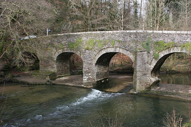
Plym Bridge. This old bridge over the river Plym is an access point to the recreational area of the Plym valley woodlands. The bridge used to be the lowest crossing on the river. It is now closed to motor vehicles to avoid this route being used as a rat run. Car parks at either side of the bridge
891:
908:== {{int:filedesc}} == {{Information |description={{en|1=Plym Bridge. This old bridge over the river Plym is an access point to the recreational area of the Plym valley woodlands. The bridge used to be the lowest crossing on the river. It is now closed
237:
374:– You must give appropriate credit, provide a link to the license, and indicate if changes were made. You may do so in any reasonable manner, but not in any way that suggests the licensor endorses you or your use.
43:
83:
51:
922:
645:
609:
573:
454:
253:
680:
1080:
291:
953:
This file contains additional information, probably added from the digital camera or scanner used to create or digitize it.
381:
836:
766:
523:
820:
786:
750:
688:
629:
557:
531:
516:
501:
716:
673:
658:
593:
474:
438:
278:
337:
956:
If the file has been modified from its original state, some details may not fully reflect the modified file.
890:
885:
42:
975:
1117:
380:– If you remix, transform, or build upon the material, you must distribute your contributions under the
298:
on the
Geograph website for the photographer's contact details. The copyright on this image is owned by
901:
334:
120:
1137:
91:
206:
115:
695:
665:
508:
190:
965:
259:
1197:
1127:
1099:
982:
303:
78:
1022:
1147:
158:
1002:
243:
179:
169:
992:
283:
295:
858:
Click on a date/time to view the file as it appeared at that time.
245:
228:
66:
779:
238:
50° 24′ 33″ N, 4° 04′ 44″ W
422:
Add a one-line explanation of what this file represents
940:
132:
109:
90:
Commons is a freely licensed media file repository.
610:
Creative
Commons Attribution-ShareAlike 2.0 Generic
56:(640 × 427 pixels, file size: 125 KB, MIME type:
1142:Flash did not fire, compulsory flash suppression
391:https://creativecommons.org/licenses/by-sa/2.0
71:
397:Creative Commons Attribution-Share Alike 2.0
315:
8:
357:– to copy, distribute and transmit the work
958:
860:
418:
138:Plym Bridge - geograph.org.uk - 121307.jpg
52:Plym_Bridge_-_geograph.org.uk_-_121307.jpg
933:The following other wikis use this file:
666:https://www.geograph.org.uk/photo/121307
509:https://www.geograph.org.uk/profile/1324
1205:
1195:
1187:
1179:
1171:
1163:
1155:
1145:
1135:
1125:
1115:
1107:
1097:
1089:
1078:
1070:
1062:
1054:
1046:
1038:
1030:
1019:
1011:
1000:
990:
980:
970:
920:
834:
818:
800:
784:
764:
748:
730:
714:
643:
627:
607:
591:
571:
555:
488:
472:
452:
436:
433:
414:
407:
231:
923:Grade II* listed buildings in Plymouth
252:View this and other nearby images on:
960:
7:
302:and is licensed for reuse under the
918:The following page uses this file:
849:
338:Attribution-Share Alike 2.0 Generic
326:
321:
306:Attribution-ShareAlike 2.0 license.
951:
427:
421:
312:
289:
142:
113:
103:
49:
426:
1013:Date and time of data generation
412:
368:Under the following conditions:
333:This file is licensed under the
325:
320:
314:
282:
258:
244:
70:
31:
21:
409:
143:
46:No higher resolution available.
14:
646:file available on the internet
408:
290:This image was taken from the
26:
1:
787:coordinates of depicted place
36:
681:Geograph Britain and Ireland
517:object of statement has role
434:Items portrayed in this file
1173:Focal plane resolution unit
1091:Date and time of digitizing
1227:
937:Usage on www.wikidata.org
382:same or compatible license
1056:File change date and time
850:
16:
1165:Focal plane Y resolution
1157:Focal plane X resolution
802:50°24'32.8"N, 4°4'44.4"W
689:geograph.org.uk image ID
411:
348:
149:give access to visitors.
77:This is a file from the
1181:Custom image processing
1094:14:00, 12 February 2006
1059:14:00, 12 February 2006
1016:14:00, 12 February 2006
907:
219:Tony Atkin /
200:Tony Atkin /
191:required by the license
175:
164:
157:
154:
135:
81:. Information from its
976:Canon EOS 350D DIGITAL
886:04:16, 31 January 2010
296:this photograph's page
264:50.409100; -4.079000
84:description page there
1040:Horizontal resolution
751:location of creation
1064:Y and C positioning
1048:Vertical resolution
987:1/160 sec (0.00625)
962:Camera manufacturer
363:– to adapt the work
114:This is a photo of
1207:Scene capture type
1202:Auto white balance
532:author name string
1214:
1213:
929:Global file usage
911:
594:copyright license
420:
311:
310:
294:collection. See
269:
268:
226:
225:
194:
130:
129:
99:
98:
79:Wikimedia Commons
32:Global file usage
1218:
1168:3,958.7628865979
1072:Exposure Program
959:
898:
732:12 February 2006
698:
693:
683:
678:
668:
663:
659:described at URL
558:copyright status
539:
536:
526:
521:
511:
506:
404:
401:
398:
395:
392:
384:as the original.
346:
335:Creative Commons
329:
328:
324:
323:
318:
317:
304:Creative Commons
292:Geograph project
286:
279:
265:
262:
248:
247:
241:
240:
229:
188:
160:
159:12 February 2006
147:
139:
133:
123:
110:
95:
74:
73:
67:
61:
59:
1226:
1225:
1221:
1220:
1219:
1217:
1216:
1215:
1160:3,954.233409611
1104:7.3219299316406
947:
927:
912:
904:
896:
852:
851:
848:
847:
846:
845:
844:
843:
842:
841:
839:
827:
826:
825:
823:
812:
811:
810:
809:
808:
807:
806:
805:
803:
793:
792:
791:
789:
778:
777:
776:
775:
774:
773:
772:
771:
769:
757:
756:
755:
753:
742:
741:
740:
739:
738:
737:
736:
735:
733:
723:
722:
721:
719:
708:
707:
706:
705:
704:
703:
702:
701:
700:
699:
694:
691:
685:
684:
679:
676:
670:
669:
664:
661:
652:
651:
650:
648:
636:
635:
634:
632:
621:
620:
619:
618:
617:
616:
615:
614:
612:
600:
599:
598:
596:
585:
584:
583:
582:
581:
580:
579:
578:
576:
564:
563:
562:
560:
549:
548:
547:
546:
545:
544:
543:
542:
541:
540:
537:
534:
528:
527:
522:
519:
513:
512:
507:
504:
495:
494:
493:
491:
481:
480:
479:
477:
466:
465:
464:
463:
462:
461:
460:
459:
457:
445:
444:
443:
441:
425:
424:
423:
406:
405:
402:
399:
396:
393:
390:
389:
347:
344:
341:
330:
307:
277:
263:
236:
235:
232:Object location
227:
216:
209:
197:
170:geograph.org.uk
150:
137:
125:
119:
116:listed building
108:
101:
100:
89:
88:
87:is shown below.
63:
57:
55:
48:
47:
12:
11:
5:
1224:
1222:
1212:
1211:
1208:
1204:
1203:
1200:
1194:
1193:
1190:
1186:
1185:
1184:Normal process
1182:
1178:
1177:
1174:
1170:
1169:
1166:
1162:
1161:
1158:
1154:
1153:
1150:
1144:
1143:
1140:
1134:
1133:
1130:
1124:
1123:
1120:
1114:
1113:
1110:
1106:
1105:
1102:
1096:
1095:
1092:
1088:
1087:
1084:
1077:
1076:
1075:Normal program
1073:
1069:
1068:
1065:
1061:
1060:
1057:
1053:
1052:
1049:
1045:
1044:
1041:
1037:
1036:
1033:
1029:
1028:
1025:
1018:
1017:
1014:
1010:
1009:
1006:
999:
998:
995:
989:
988:
985:
979:
978:
973:
969:
968:
963:
950:
946:
945:
944:
943:
931:
930:
926:
925:
916:
915:
910:
909:
906:
902:
899:
893:
888:
883:
879:
878:
875:
872:
869:
866:
863:
856:
855:
840:
837:Canon EOS 350D
835:
833:
832:
831:
830:
829:
828:
824:
819:
817:
816:
815:
814:
813:
804:
801:
799:
798:
797:
796:
795:
794:
790:
785:
783:
782:
781:
780:
770:
765:
763:
762:
761:
760:
759:
758:
754:
749:
747:
746:
745:
744:
743:
734:
731:
729:
728:
727:
726:
725:
724:
720:
715:
713:
712:
711:
710:
709:
687:
686:
672:
671:
657:
656:
655:
654:
653:
649:
644:
642:
641:
640:
639:
638:
637:
633:
630:source of file
628:
626:
625:
624:
623:
622:
613:
608:
606:
605:
604:
603:
602:
601:
597:
592:
590:
589:
588:
587:
586:
577:
572:
570:
569:
568:
567:
566:
565:
561:
556:
554:
553:
552:
551:
550:
530:
529:
515:
514:
500:
499:
498:
497:
496:
492:
489:
487:
486:
485:
484:
483:
482:
478:
473:
471:
470:
469:
468:
467:
458:
453:
451:
450:
449:
448:
447:
446:
442:
437:
435:
432:
431:
430:
429:
428:
417:
416:
413:
410:
388:
387:
386:
385:
375:
366:
365:
364:
358:
351:You are free:
342:
332:
331:
313:
309:
308:
287:
276:
273:
267:
266:
256:
250:
233:
224:
223:
217:
214:
211:
210:
205:
198:
195:
183:
182:
177:
173:
172:
166:
162:
161:
156:
152:
151:
140:
131:
128:
127:
107:
104:
102:
97:
96:
75:
65:
64:
45:
41:
40:
39:
34:
29:
24:
19:
13:
10:
9:
6:
4:
3:
2:
1223:
1209:
1206:
1201:
1199:
1198:White balance
1196:
1192:Auto exposure
1191:
1189:Exposure mode
1188:
1183:
1180:
1175:
1172:
1167:
1164:
1159:
1156:
1151:
1149:
1146:
1141:
1139:
1136:
1131:
1129:
1128:Metering mode
1126:
1121:
1119:
1118:Exposure bias
1116:
1111:
1109:APEX aperture
1108:
1103:
1101:
1100:Shutter speed
1098:
1093:
1090:
1085:
1082:
1079:
1074:
1071:
1066:
1063:
1058:
1055:
1050:
1047:
1042:
1039:
1034:
1031:
1026:
1024:
1020:
1015:
1012:
1007:
1004:
1001:
996:
994:
991:
986:
984:
983:Exposure time
981:
977:
974:
971:
967:
964:
961:
957:
954:
948:
942:
939:
938:
936:
935:
934:
928:
924:
921:
919:
913:
905:
900:
894:
892:
889:
887:
884:
881:
880:
876:
873:
870:
867:
864:
862:
861:
859:
853:
838:
822:
821:captured with
788:
768:
752:
718:
697:
690:
682:
675:
667:
660:
647:
631:
611:
595:
575:
559:
533:
525:
518:
510:
503:
476:
456:
440:
394:CC BY-SA 2.0
383:
379:
376:
373:
370:
369:
367:
362:
359:
356:
353:
352:
350:
349:
343:Attribution:
339:
336:
319:
305:
301:
297:
293:
288:
285:
281:
280:
274:
272:
271:
261:
257:
255:
254:OpenStreetMap
251:
249:
239:
234:
230:
222:
218:
213:
212:
208:
204: /
203:
199:
192:
187:
185:
184:
181:
178:
174:
171:
167:
163:
153:
146:
141:
134:
126:
122:
117:
112:
111:
105:
93:
86:
85:
80:
76:
69:
68:
62:
53:
44:
38:
35:
33:
30:
28:
25:
23:
20:
18:
15:
1023:focal length
972:Camera model
955:
952:
932:
917:
857:
854:File history
524:photographer
377:
371:
360:
354:
299:
270:
220:
207:CC BY-SA 2.0
201:
144:
92:You can help
82:
50:
22:File history
1148:Color space
1032:Orientation
903:GeographBot
574:copyrighted
455:Plym Bridge
378:share alike
372:attribution
221:Plym Bridge
202:Plym Bridge
186:Attribution
136:Description
914:File usage
895:640 × 427
871:Dimensions
538:Tony Atkin
490:some value
345:Tony Atkin
300:Tony Atkin
180:Tony Atkin
58:image/jpeg
27:File usage
1003:ISO speed
941:Q17554241
868:Thumbnail
865:Date/Time
717:inception
275:Licensing
215:InfoField
196:InfoField
145:English:
1210:Standard
1067:Co-sited
993:F-number
949:Metadata
897:(125 KB)
767:Plymouth
674:operator
415:Captions
361:to remix
355:to share
340:license.
37:Metadata
1132:Pattern
1083:version
882:current
877:Comment
475:creator
439:depicts
419:English
121:1386329
118:number
106:Summary
54:
1176:inches
1051:72 dpi
1043:72 dpi
1035:Normal
1005:rating
696:121307
242:
176:Author
165:Source
1138:Flash
1027:24 mm
1021:Lens
966:Canon
168:From
1152:sRGB
1086:2.21
1081:Exif
874:User
403:true
400:true
155:Date
17:File
1008:400
997:f/8
502:URL
692::
677::
662::
535::
520::
505::
1122:0
1112:6
193:)
189:(
124:.
94:.
60:)
Text is available under the Creative Commons Attribution-ShareAlike License. Additional terms may apply.
_&language=en)
