158:
Register of
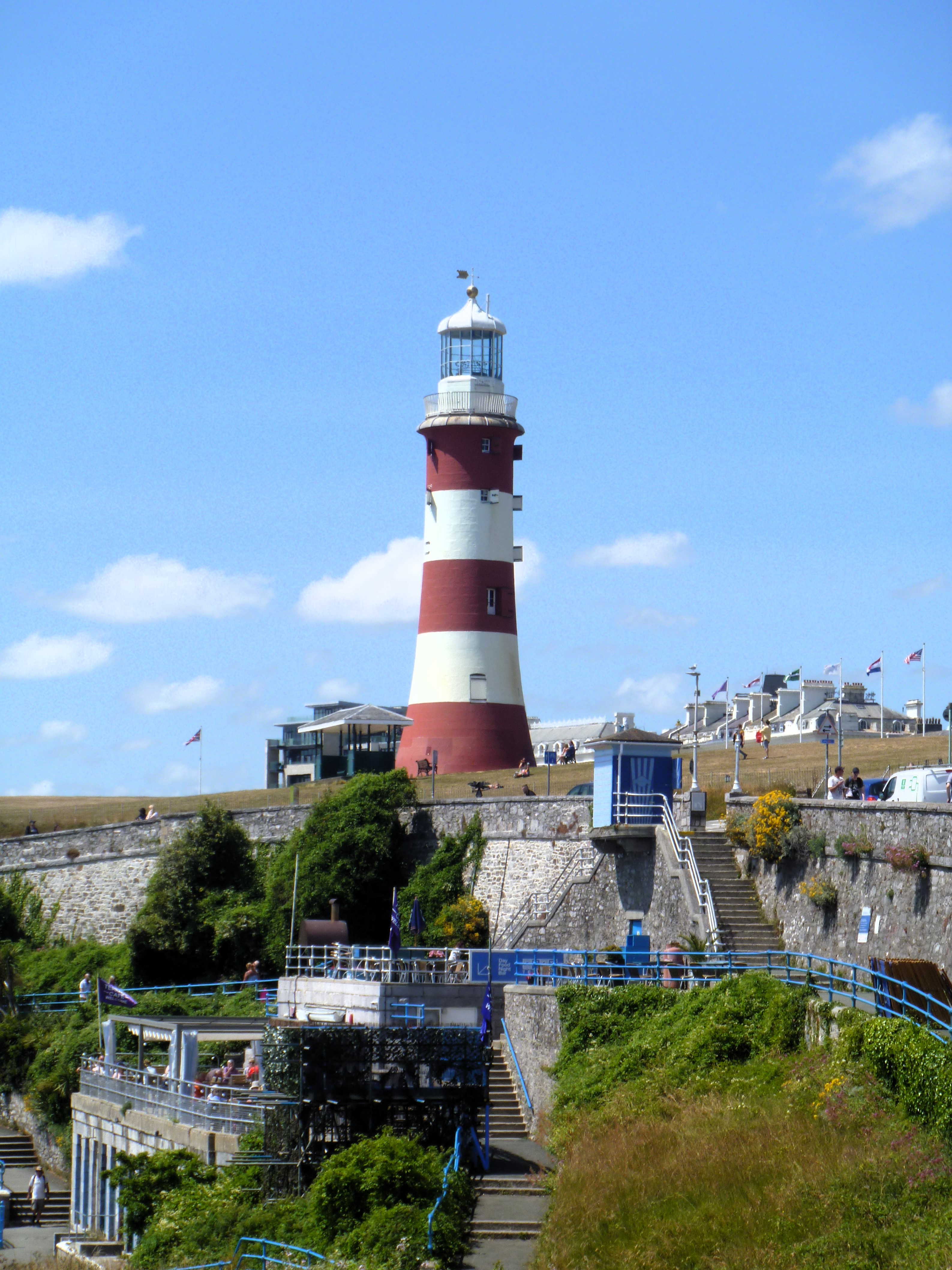
Historic Parks and Gardens, grade II. Plymouth is a port city on the south coast of Devon, some 36 miles (58 km) southwest of Exeter. Settlement in the area dates back into the Bronze Age and it was a Roman trading post. The city became an important shipping port, handling imports and passengers from the Americas, and exporting local minerals. A Royal Navy dockyard was constructed in 1690 at nearby Devonport, now incorporated into Plymouth, which, today, is the largest operational naval base in Western Europe. During World War II, this important naval presence led to the German military targeting and partially destroying the city by bombing.
43:
1021:== {{int:filedesc}} == {{Information |Description={{en|1=Smeaton's Tower on The Hoe is the upper part of the former Eddystone Lighthouse, built in 1759 by John Smeaton, erected here on a new base in 1882. It comprises a circular tapered tower of painted granite ashlar. The tower is listed, grade I, with details at: LinkExternal link. The Hoe is on the Register of Historic Parks and Gardens, grade II. Plymouth is a port city on the south coast of Devon, some 36 miles (58 km) southwest of Exete...
396:
329:
279:
321:
271:
343:
293:
364:
402:
407:
103:
638:"}},"text\/plain":{"en":{"":"heading"}}},"{\"value\":{\"amount\":\"+292.0\",\"unit\":\"http:\\\/\\\/www.wikidata.org\\\/entity\\\/Q28390\"},\"type\":\"quantity\"}":{"text\/html":{"en":{"P7787":"292.0
902:"}},"text\/plain":{"en":{"":"heading"}}},"{\"value\":{\"amount\":\"+292\",\"unit\":\"http:\\\/\\\/www.wikidata.org\\\/entity\\\/Q28390\"},\"type\":\"quantity\"}":{"text\/html":{"en":{"P7787":"292
898:
312:
262:
454:– You must give appropriate credit, provide a link to the license, and indicate if changes were made. You may do so in any reasonable manner, but not in any way that suggests the licensor endorses you or your use.
69:
65:
61:
57:
53:
47:
82:
899:
635:
114:
199:
1053:
773:
587:
551:
336:
286:
371:
1076:
This file contains additional information, probably added from the digital camera or scanner used to create or digitize it.
461:
940:
913:
868:
831:
794:
739:
705:
676:
649:
535:
766:
607:
571:
518:
1003:
998:
73:
42:
358:
417:
1079:
If the file has been modified from its original state, some details may not fully reflect the modified file.
460:– If you remix, transform, or build upon the material, you must distribute your contributions under the
378:
on the
Geograph website for the photographer's contact details. The copyright on this image is owned by
642:"}},"text\/plain":{"en":{"P7787":"292.0 degree"}}}}": -->
1014:
414:
906:"}},"text\/plain":{"en":{"P7787":"292 degree"}}}}": -->
1158:
122:
1098:
215:
342:
292:
1184:
1140:
383:
109:
231:
276:
326:
167:
1105:
1088:
188:
178:
1035:
363:
375:
971:
Click on a date/time to view the file as it appeared at that time.
1127:
Landscape mode (for landscape photos with the background in focus)
328:
278:
313:
50° 21′ 51.66″ N, 4° 08′ 30.6″ W
303:
253:
97:
263:
50° 21′ 48.6″ N, 4° 08′ 20″ W
502:
Add a one-line explanation of what this file represents
87:(3,174 × 4,232 pixels, file size: 2.22 MB, MIME type:
1063:
206:
Creative
Commons Attribution Share-alike license 2.0
141:
121:
Commons is a freely licensed media file repository.
588:
Creative
Commons Attribution-ShareAlike 2.0 Generic
1163:Flash did not fire, compulsory flash suppression
471:https://creativecommons.org/licenses/by-sa/2.0
102:
477:Creative Commons Attribution-Share Alike 2.0
395:
147:Plymouth buildings -4- (geograph 7633033).jpg
8:
903:
639:
437:– to copy, distribute and transmit the work
1081:
973:
498:
1046:The following other wikis use this file:
755:af58f6cca89bf848411373f770eac7d864c4aa27
1192:
1182:
1174:
1166:
1156:
1148:
1138:
1130:
1122:
1114:
1103:
1093:
1033:
927:
911:
882:
866:
845:
829:
808:
792:
753:
737:
719:
703:
663:
647:
621:
605:
585:
569:
549:
533:
516:
513:
494:
487:
306:
256:
335:View this and other nearby images on:
285:View this and other nearby images on:
1083:
7:
382:and is licensed for reuse under the
1031:The following page uses this file:
962:
418:Attribution-Share Alike 2.0 Generic
406:
401:
386:Attribution-ShareAlike 2.0 license.
1074:
507:
501:
392:
369:
151:
134:
80:
506:
1116:Date and time of data generation
650:coordinates of the point of view
492:
448:Under the following conditions:
413:This file is licensed under the
405:
400:
394:
362:
341:
327:
319:
291:
277:
269:
101:
31:
21:
489:
152:
14:
488:
370:This image was taken from the
26:
1:
914:coordinates of depicted place
36:
1176:DateTimeDigitized subseconds
929:50°21'51.660"N, 4°8'30.624"W
665:50°21'48.650"N, 4°8'20.472"W
514:Items portrayed in this file
318:
268:
1168:DateTimeOriginal subseconds
1132:Date and time of digitizing
1214:
1194:Focal length in 35 mm film
1060:Usage on lv.wikipedia.org
1050:Usage on fa.wikipedia.org
462:same or compatible license
963:
244:Michael Dibb /
225:Michael Dibb /
16:
491:
428:
108:This is a file from the
1020:
216:required by the license
194:
184:
173:
166:
163:
144:
112:. Information from its
376:this photograph's page
347:50.364350; -4.141840
297:50.363514; -4.139020
115:description page there
46:Size of this preview:
999:21:27, 23 April 2024
767:determination method
74:3,174 × 4,232 pixels
70:1,536 × 2,048 pixels
1135:13:50, 29 June 2023
1119:13:50, 29 June 2023
1085:Camera manufacturer
443:– to adapt the work
246:Plymouth buildings
227:Plymouth buildings
52:Other resolutions:
1189:Auto white balance
66:768 × 1,024 pixels
1201:
1200:
1054:پلیموث (انگلستان)
1042:Global file usage
1024:
905:
641:
572:copyright license
500:
391:
390:
374:collection. See
352:
351:
302:
301:
251:
250:
219:
203:
200:Reusing this file
130:
129:
110:Wikimedia Commons
32:Global file usage
1205:
1124:Exposure Program
1082:
1011:
951:
950:
945:
887:
850:
813:
776:
771:
687:
686:
681:
536:copyright status
484:
481:
478:
475:
472:
464:as the original.
426:
415:Creative Commons
409:
408:
404:
403:
398:
397:
384:Creative Commons
372:Geograph project
366:
359:
348:
345:
331:
330:
324:
323:
322:
316:
315:
304:
298:
295:
281:
280:
274:
273:
272:
266:
265:
254:
213:
197:
169:
156:
148:
142:
126:
105:
104:
98:
92:
90:
77:
62:576 × 768 pixels
58:360 × 480 pixels
54:180 × 240 pixels
48:450 × 600 pixels
1213:
1212:
1208:
1207:
1206:
1204:
1203:
1202:
1070:
1040:
1025:
1017:
1016:Chocolateediter
1009:
965:
964:
961:
960:
959:
958:
957:
956:
955:
954:
953:
952:
948:
946:
943:
934:
933:
932:
930:
920:
919:
918:
916:
897:
896:
895:
894:
893:
892:
891:
890:
888:
885:
875:
874:
873:
871:
860:
859:
858:
857:
856:
855:
854:
853:
851:
848:
838:
837:
836:
834:
823:
822:
821:
820:
819:
818:
817:
816:
814:
811:
801:
800:
799:
797:
786:
785:
784:
783:
782:
781:
780:
779:
778:
777:
774:saquina chaúque
772:
769:
760:
759:
758:
756:
746:
745:
744:
742:
731:
730:
729:
728:
727:
726:
725:
724:
722:
712:
711:
710:
708:
697:
696:
695:
694:
693:
692:
691:
690:
689:
688:
684:
682:
679:
670:
669:
668:
666:
656:
655:
654:
652:
633:
632:
631:
630:
629:
628:
627:
626:
624:
614:
613:
612:
610:
599:
598:
597:
596:
595:
594:
593:
592:
590:
578:
577:
576:
574:
563:
562:
561:
560:
559:
558:
557:
556:
554:
542:
541:
540:
538:
527:
526:
525:
524:
523:
521:
505:
504:
503:
486:
485:
482:
479:
476:
473:
470:
469:
427:
424:
421:
410:
387:
357:
346:
320:
311:
310:
307:Object location
296:
270:
261:
260:
257:Camera location
252:
241:
234:
222:
179:geograph.org.uk
159:
146:
139:
132:
131:
120:
119:
118:is shown below.
94:
88:
86:
79:
78:
51:
12:
11:
5:
1211:
1209:
1199:
1198:
1195:
1191:
1190:
1187:
1181:
1180:
1177:
1173:
1172:
1169:
1165:
1164:
1161:
1155:
1154:
1151:
1147:
1146:
1143:
1137:
1136:
1133:
1129:
1128:
1125:
1121:
1120:
1117:
1113:
1112:
1109:
1102:
1101:
1096:
1092:
1091:
1086:
1073:
1069:
1068:
1067:
1066:
1058:
1057:
1056:
1044:
1043:
1039:
1038:
1029:
1028:
1023:
1022:
1019:
1015:
1012:
1008:3,174 × 4,232
1006:
1001:
996:
992:
991:
988:
985:
982:
979:
976:
969:
968:
939:
938:
937:
936:
935:
931:
928:
926:
925:
924:
923:
922:
921:
917:
912:
910:
909:
908:
907:
901:
889:
883:
881:
880:
879:
878:
877:
876:
872:
867:
865:
864:
863:
862:
861:
852:
846:
844:
843:
842:
841:
840:
839:
835:
830:
828:
827:
826:
825:
824:
815:
809:
807:
806:
805:
804:
803:
802:
798:
793:
791:
790:
789:
788:
787:
765:
764:
763:
762:
761:
757:
754:
752:
751:
750:
749:
748:
747:
743:
738:
736:
735:
734:
733:
732:
723:
720:
718:
717:
716:
715:
714:
713:
709:
704:
702:
701:
700:
699:
698:
675:
674:
673:
672:
671:
667:
664:
662:
661:
660:
659:
658:
657:
653:
648:
646:
645:
644:
643:
637:
625:
622:
620:
619:
618:
617:
616:
615:
611:
606:
604:
603:
602:
601:
600:
591:
586:
584:
583:
582:
581:
580:
579:
575:
570:
568:
567:
566:
565:
564:
555:
550:
548:
547:
546:
545:
544:
543:
539:
534:
532:
531:
530:
529:
528:
522:
517:
515:
512:
511:
510:
509:
508:
497:
496:
493:
490:
468:
467:
466:
465:
455:
446:
445:
444:
438:
431:You are free:
422:
412:
411:
393:
389:
388:
367:
356:
353:
350:
349:
339:
333:
308:
300:
299:
289:
283:
258:
249:
248:
242:
239:
236:
235:
230:
223:
220:
208:
207:
204:
192:
191:
186:
182:
181:
175:
171:
170:
165:
161:
160:
149:
140:
138:
135:
133:
128:
127:
106:
96:
95:
45:
41:
40:
39:
34:
29:
24:
19:
13:
10:
9:
6:
4:
3:
2:
1210:
1196:
1193:
1188:
1186:
1185:White balance
1183:
1178:
1175:
1170:
1167:
1162:
1160:
1157:
1152:
1149:
1144:
1142:
1141:Metering mode
1139:
1134:
1131:
1126:
1123:
1118:
1115:
1110:
1107:
1104:
1100:
1097:
1094:
1090:
1087:
1084:
1080:
1077:
1071:
1065:
1062:
1061:
1059:
1055:
1052:
1051:
1049:
1048:
1047:
1041:
1037:
1034:
1032:
1026:
1018:
1013:
1007:
1005:
1002:
1000:
997:
994:
993:
989:
986:
983:
980:
977:
975:
974:
972:
966:
942:
915:
870:
833:
796:
775:
768:
741:
707:
678:
651:
609:
589:
573:
553:
537:
520:
474:CC BY-SA 2.0
463:
459:
456:
453:
450:
449:
447:
442:
439:
436:
433:
432:
430:
429:
423:Attribution:
419:
416:
399:
385:
381:
377:
373:
368:
365:
361:
360:
354:
344:
340:
338:
337:OpenStreetMap
334:
332:
314:
309:
305:
294:
290:
288:
287:OpenStreetMap
284:
282:
264:
259:
255:
247:
243:
238:
237:
233:
229: /
228:
224:
217:
212:
210:
209:
205:
201:
196:
193:
190:
187:
183:
180:
176:
172:
162:
155:
150:
143:
136:
124:
117:
116:
111:
107:
100:
99:
93:
84:
83:Original file
75:
71:
67:
63:
59:
55:
49:
44:
38:
35:
33:
30:
28:
25:
23:
20:
18:
15:
1150:Light source
1095:Camera model
1078:
1075:
1045:
1030:
970:
967:File history
623:29 June 2023
457:
451:
440:
434:
425:Michael Dibb
380:Michael Dibb
379:
317:
267:
245:
232:CC BY-SA 2.0
226:
189:Michael Dibb
168:29 June 2023
153:
123:You can help
113:
81:
22:File history
552:copyrighted
458:share alike
452:attribution
211:Attribution
145:Description
1027:File usage
984:Dimensions
810:2,332,696
721:image/jpeg
706:media type
195:Permission
89:image/jpeg
27:File usage
1106:ISO speed
1089:Panasonic
1010:(2.22 MB)
981:Thumbnail
978:Date/Time
795:data size
608:inception
355:Licensing
240:InfoField
221:InfoField
154:English:
1099:DMC-FT10
1072:Metadata
1036:Plymouth
740:checksum
495:Captions
441:to remix
435:to share
420:license.
37:Metadata
1153:Unknown
1145:Pattern
1064:Plimuta
995:current
990:Comment
941:heading
900:heading
677:heading
636:heading
519:depicts
499:English
137:Summary
85:
1197:101 mm
1108:rating
949:degree
904:degree
884:3,174
847:4,232
832:height
685:degree
683:292.0
640:degree
325:
275:
185:Author
174:Source
1159:Flash
886:pixel
869:width
849:pixel
177:From
987:User
947:292
812:byte
483:true
480:true
164:Date
17:File
1179:00
1171:00
1111:80
944::
770::
680::
72:|
68:|
64:|
60:|
56:|
50:.
218:)
214:(
202:)
198:(
125:.
91:)
76:.
Text is available under the Creative Commons Attribution-ShareAlike License. Additional terms may apply.
.jpg)
.jpg¶ms=050.363514_N_-004.139020_E_globe:Earth_type:camera_source:geograph-osgb36(SX47965370)_heading:292.00&language=en)
.jpg¶ms=050.364350_N_-004.141840_E_globe:Earth_class:object_type:object_source:geograph-osgb36(SX4776253799)_heading:292.00&language=en)