347:
280:
230:
272:
222:
294:
244:
315:
353:
358:
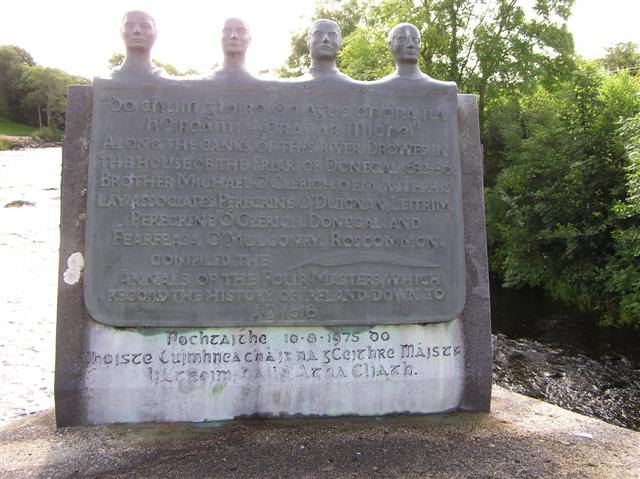
125:. It is in Irish and English, the latter reads, "Along the banks of this river, Drowes, in the house of the Friars of Donegal 1632-36, brother Michael Clérich, O.F.M. with his lay associates Peregrine O'Duignan, Leitrim, Peregrine Ó Clérich, Donegal and Fearfeasa O'Mulconry, Roscommon complied the Annals of the Four Masters which record the history of Ireland down to AD1616"
67:
823:"}},"text\/plain":{"en":{"":"heading"}}},"{\"value\":{\"amount\":\"+135\",\"unit\":\"http:\\\/\\\/www.wikidata.org\\\/entity\\\/Q28390\"},\"type\":\"quantity\"}":{"text\/html":{"en":{"P7787":"135
638:"}},"text\/plain":{"en":{"":"heading"}}},"{\"value\":{\"amount\":\"+135\",\"unit\":\"http:\\\/\\\/www.wikidata.org\\\/entity\\\/Q28390\"},\"type\":\"quantity\"}":{"text\/html":{"en":{"P7787":"135
819:
263:
213:
1190:== {{int:filedesc}} == {{Information |description={{en|1=Plaque, Drones River It is located on the bridge here . It is in Irish and English, the latter reads, "Along the banks of this river, Drowes, in the house of the Friars of Donegal 1632-
38:
405:– You must give appropriate credit, provide a link to the license, and indicate if changes were made. You may do so in any reasonable manner, but not in any way that suggests the licensor endorses you or your use.
122:
78:
46:
820:
635:
1209:
906:
755:
621:
585:
287:
237:
805:
1450:
322:
1230:
This file contains additional information, probably added from the digital camera or scanner used to create or digitize it.
1084:
412:
520:
1172:
1167:
1104:
1034:
997:
963:
926:
890:
861:
834:
768:
739:
676:
649:
569:
541:
528:
513:
37:
798:
783:
705:
605:
486:
469:
1068:
1204:
309:
368:
1233:
If the file has been modified from its original state, some details may not fully reflect the modified file.
1477:
1219:
411:– If you remix, transform, or build upon the material, you must distribute your contributions under the
329:
on the
Geograph website for the photographer's contact details. The copyright on this image is owned by
1183:
365:
827:"}},"text\/plain":{"en":{"P7787":"135 degree"}}}}": -->
642:"}},"text\/plain":{"en":{"P7787":"135 degree"}}}}": -->
1513:
1250:
86:
1344:
1412:
790:
775:
548:
166:
293:
243:
1495:
1383:
1267:
1214:
334:
73:
1422:
1393:
1307:
182:
1523:
134:
1287:
277:
227:
145:
155:
1432:
1277:
314:
326:
1260:
1140:
Click on a date/time to view the file as it appeared at that time.
279:
229:
254:
204:
61:
264:
54° 27′ 32″ N, 8° 15′ 38″ W
214:
54° 27′ 33″ N, 8° 15′ 39″ W
453:
Add a one-line explanation of what this file represents
111:
Plaque, Drones River - geograph.org.uk - 1422094.jpg
105:
85:
Commons is a freely licensed media file repository.
47:
Plaque,_Drones_River_-_geograph.org.uk_-_1422094.jpg
622:
Creative
Commons Attribution-ShareAlike 2.0 Generic
121:Plaque, Drones River It is located on the bridge
1518:Flash did not fire, compulsory flash suppression
51:(640 × 479 pixels, file size: 65 KB, MIME type:
1445:Creative program (biased toward depth of field)
422:https://creativecommons.org/licenses/by-sa/2.0
66:
428:Creative Commons Attribution-Share Alike 2.0
346:
8:
824:
639:
388:– to copy, distribute and transmit the work
1235:
1142:
449:
791:https://www.geograph.org.uk/photo/1422094
549:https://www.geograph.org.uk/profile/2282
1521:
1511:
1503:
1493:
1485:
1475:
1467:
1459:
1448:
1440:
1430:
1420:
1410:
1402:
1391:
1381:
1373:
1365:
1357:
1349:
1339:
1331:
1323:
1315:
1304:
1296:
1285:
1275:
1265:
1255:
1237:
1202:
1118:
1102:
1082:
1066:
1048:
1032:
1011:
995:
977:
961:
940:
924:
904:
888:
848:
832:
753:
737:
719:
703:
663:
647:
619:
603:
583:
567:
500:
484:
467:
464:
445:
438:
257:
207:
286:View this and other nearby images on:
236:View this and other nearby images on:
1245:
1200:The following 4 pages use this file:
7:
333:and is licensed for reuse under the
1131:
369:Attribution-Share Alike 2.0 Generic
357:
352:
337:Attribution-ShareAlike 2.0 license.
1228:
458:
452:
343:
320:
115:
98:
44:
457:
1298:Date and time of data generation
650:coordinates of the point of view
443:
399:Under the following conditions:
364:This file is licensed under the
356:
351:
345:
313:
292:
278:
270:
242:
228:
220:
65:
21:
1242:OLYMPUS DIGITAL CAMERA
440:
116:
41:No higher resolution available.
14:
756:file available on the internet
439:
321:This image was taken from the
26:
1:
1210:Cú Choigríche Ó Duibhgeannáin
835:coordinates of depicted place
31:
806:Geograph Britain and Ireland
514:object of statement has role
465:Items portrayed in this file
269:
219:
1461:Date and time of digitizing
850:54°27'32.15"N, 8°15'38.16"W
665:54°27'32.80"N, 8°15'38.88"W
195:Kenneth Allen /
176:Kenneth Allen /
1545:
1205:Annals of the Four Masters
413:same or compatible license
1351:File change date and time
1132:
16:
907:Olympus C-750 Ultra Zoom
769:geograph.org.uk image ID
442:
379:
72:This is a file from the
1367:Custom image processing
1220:Hugh Roe O'Donnell
1189:
167:required by the license
151:
140:
133:
130:
108:
76:. Information from its
1469:Image compression mode
327:this photograph's page
298:54.458930; -8.260600
248:54.459110; -8.260800
79:description page there
1487:Maximum land aperture
1325:Horizontal resolution
197:Plaque, Drones River
178:Plaque, Drones River
1464:10:49, 30 July 2009
1359:Y and C positioning
1354:08:35, 31 July 2009
1333:Vertical resolution
1301:10:49, 30 July 2009
1251:OLYMPUS CORPORATION
1247:Camera manufacturer
1168:20:09, 1 March 2011
394:– to adapt the work
1404:Scene capture type
1388:Auto white balance
529:author name string
1532:
1531:
1272:1/80 sec (0.0125)
1193:
826:
641:
606:copyright license
451:
342:
341:
325:collection. See
303:
302:
253:
252:
202:
201:
170:
94:
93:
74:Wikimedia Commons
1536:
1442:Exposure Program
1236:
1180:
1016:
945:
872:
871:
866:
808:
803:
793:
788:
784:described at URL
778:
773:
687:
686:
681:
570:copyright status
551:
546:
536:
533:
523:
518:
435:
432:
429:
426:
423:
415:as the original.
377:
366:Creative Commons
360:
359:
355:
354:
349:
348:
335:Creative Commons
323:Geograph project
317:
310:
299:
296:
282:
281:
275:
274:
273:
267:
266:
255:
249:
246:
232:
231:
225:
224:
223:
217:
216:
205:
164:
136:
120:
112:
106:
90:
69:
68:
62:
56:
54:
1544:
1543:
1539:
1538:
1537:
1535:
1534:
1533:
1490:3 APEX (f/2.83)
1224:
1194:
1186:
1178:
1134:
1133:
1130:
1129:
1128:
1127:
1126:
1125:
1124:
1123:
1121:
1111:
1110:
1109:
1107:
1096:
1095:
1094:
1093:
1092:
1091:
1090:
1089:
1087:
1075:
1074:
1073:
1071:
1060:
1059:
1058:
1057:
1056:
1055:
1054:
1053:
1051:
1041:
1040:
1039:
1037:
1026:
1025:
1024:
1023:
1022:
1021:
1020:
1019:
1017:
1014:
1004:
1003:
1002:
1000:
989:
988:
987:
986:
985:
984:
983:
982:
980:
970:
969:
968:
966:
955:
954:
953:
952:
951:
950:
949:
948:
946:
943:
933:
932:
931:
929:
918:
917:
916:
915:
914:
913:
912:
911:
909:
897:
896:
895:
893:
882:
881:
880:
879:
878:
877:
876:
875:
874:
873:
869:
867:
864:
855:
854:
853:
851:
841:
840:
839:
837:
818:
817:
816:
815:
814:
813:
812:
811:
810:
809:
804:
801:
795:
794:
789:
786:
780:
779:
774:
771:
762:
761:
760:
758:
746:
745:
744:
742:
731:
730:
729:
728:
727:
726:
725:
724:
722:
712:
711:
710:
708:
697:
696:
695:
694:
693:
692:
691:
690:
689:
688:
684:
682:
679:
670:
669:
668:
666:
656:
655:
654:
652:
633:
632:
631:
630:
629:
628:
627:
626:
624:
612:
611:
610:
608:
597:
596:
595:
594:
593:
592:
591:
590:
588:
576:
575:
574:
572:
561:
560:
559:
558:
557:
556:
555:
554:
553:
552:
547:
544:
538:
537:
534:
531:
525:
524:
519:
516:
507:
506:
505:
503:
493:
492:
491:
489:
478:
477:
476:
475:
474:
472:
456:
455:
454:
437:
436:
433:
430:
427:
424:
421:
420:
378:
375:
372:
361:
338:
308:
297:
271:
262:
261:
258:Object location
247:
221:
212:
211:
208:Camera location
203:
192:
185:
173:
146:geograph.org.uk
126:
110:
103:
96:
95:
84:
83:
82:is shown below.
58:
52:
50:
43:
42:
12:
11:
5:
1542:
1540:
1530:
1529:
1526:
1520:
1519:
1516:
1510:
1509:
1506:
1502:
1501:
1498:
1492:
1491:
1488:
1484:
1483:
1480:
1474:
1473:
1470:
1466:
1465:
1462:
1458:
1457:
1454:
1447:
1446:
1443:
1439:
1438:
1435:
1429:
1428:
1425:
1419:
1418:
1415:
1409:
1408:
1405:
1401:
1400:
1397:
1390:
1389:
1386:
1380:
1379:
1376:
1372:
1371:
1370:Normal process
1368:
1364:
1363:
1360:
1356:
1355:
1352:
1348:
1347:
1342:
1338:
1337:
1334:
1330:
1329:
1326:
1322:
1321:
1318:
1314:
1313:
1310:
1303:
1302:
1299:
1295:
1294:
1291:
1284:
1283:
1280:
1274:
1273:
1270:
1264:
1263:
1258:
1254:
1253:
1248:
1244:
1243:
1240:
1227:
1223:
1222:
1217:
1212:
1207:
1198:
1197:
1192:
1191:
1188:
1184:
1181:
1175:
1170:
1165:
1161:
1160:
1157:
1154:
1151:
1148:
1145:
1138:
1137:
1122:
1119:
1117:
1116:
1115:
1114:
1113:
1112:
1108:
1103:
1101:
1100:
1099:
1098:
1097:
1088:
1083:
1081:
1080:
1079:
1078:
1077:
1076:
1072:
1067:
1065:
1064:
1063:
1062:
1061:
1052:
1049:
1047:
1046:
1045:
1044:
1043:
1042:
1038:
1033:
1031:
1030:
1029:
1028:
1027:
1018:
1012:
1010:
1009:
1008:
1007:
1006:
1005:
1001:
996:
994:
993:
992:
991:
990:
981:
978:
976:
975:
974:
973:
972:
971:
967:
962:
960:
959:
958:
957:
956:
947:
941:
939:
938:
937:
936:
935:
934:
930:
925:
923:
922:
921:
920:
919:
910:
905:
903:
902:
901:
900:
899:
898:
894:
889:
887:
886:
885:
884:
883:
860:
859:
858:
857:
856:
852:
849:
847:
846:
845:
844:
843:
842:
838:
833:
831:
830:
829:
828:
822:
797:
796:
782:
781:
767:
766:
765:
764:
763:
759:
754:
752:
751:
750:
749:
748:
747:
743:
740:source of file
738:
736:
735:
734:
733:
732:
723:
720:
718:
717:
716:
715:
714:
713:
709:
704:
702:
701:
700:
699:
698:
675:
674:
673:
672:
671:
667:
664:
662:
661:
660:
659:
658:
657:
653:
648:
646:
645:
644:
643:
637:
625:
620:
618:
617:
616:
615:
614:
613:
609:
604:
602:
601:
600:
599:
598:
589:
584:
582:
581:
580:
579:
578:
577:
573:
568:
566:
565:
564:
563:
562:
540:
539:
527:
526:
512:
511:
510:
509:
508:
504:
501:
499:
498:
497:
496:
495:
494:
490:
485:
483:
482:
481:
480:
479:
473:
468:
466:
463:
462:
461:
460:
459:
448:
447:
444:
441:
419:
418:
417:
416:
406:
397:
396:
395:
389:
382:You are free:
373:
363:
362:
344:
340:
339:
318:
307:
304:
301:
300:
290:
284:
259:
251:
250:
240:
234:
209:
200:
199:
193:
190:
187:
186:
181:
174:
171:
159:
158:
153:
149:
148:
142:
138:
137:
132:
128:
127:
113:
104:
102:
99:
97:
92:
91:
70:
60:
59:
40:
36:
35:
34:
29:
24:
19:
13:
10:
9:
6:
4:
3:
2:
1541:
1527:
1525:
1522:
1517:
1515:
1512:
1507:
1504:
1499:
1497:
1496:Metering mode
1494:
1489:
1486:
1481:
1479:
1478:Exposure bias
1476:
1471:
1468:
1463:
1460:
1455:
1452:
1449:
1444:
1441:
1436:
1434:
1431:
1426:
1424:
1421:
1416:
1414:
1411:
1406:
1403:
1398:
1395:
1392:
1387:
1385:
1384:White balance
1382:
1378:Auto exposure
1377:
1375:Exposure mode
1374:
1369:
1366:
1361:
1358:
1353:
1350:
1346:
1343:
1341:Software used
1340:
1335:
1332:
1327:
1324:
1319:
1316:
1311:
1309:
1305:
1300:
1297:
1292:
1289:
1286:
1281:
1279:
1276:
1271:
1269:
1268:Exposure time
1266:
1262:
1259:
1256:
1252:
1249:
1246:
1241:
1238:
1234:
1231:
1225:
1221:
1218:
1216:
1215:Donegal Abbey
1213:
1211:
1208:
1206:
1203:
1201:
1195:
1187:
1182:
1176:
1174:
1171:
1169:
1166:
1163:
1162:
1158:
1155:
1152:
1149:
1146:
1144:
1143:
1141:
1135:
1106:
1086:
1070:
1036:
999:
965:
928:
927:exposure time
908:
892:
891:captured with
863:
836:
807:
800:
792:
785:
777:
770:
757:
741:
707:
678:
651:
623:
607:
587:
571:
550:
543:
535:Kenneth Allen
530:
522:
515:
488:
471:
425:CC BY-SA 2.0
414:
410:
407:
404:
401:
400:
398:
393:
390:
387:
384:
383:
381:
380:
376:Kenneth Allen
374:Attribution:
370:
367:
350:
336:
332:
331:Kenneth Allen
328:
324:
319:
316:
312:
311:
305:
295:
291:
289:
288:OpenStreetMap
285:
283:
265:
260:
256:
245:
241:
239:
238:OpenStreetMap
235:
233:
215:
210:
206:
198:
194:
189:
188:
184:
180: /
179:
175:
168:
163:
161:
160:
157:
156:Kenneth Allen
154:
150:
147:
143:
139:
129:
124:
119:
114:
107:
100:
88:
81:
80:
75:
71:
64:
63:
57:
48:
39:
33:
30:
28:
25:
23:
20:
18:
15:
1505:Light source
1394:Digital zoom
1308:focal length
1257:Camera model
1232:
1229:
1199:
1139:
1136:File history
998:focal length
721:30 July 2009
521:photographer
408:
402:
391:
385:
330:
268:
218:
196:
183:CC BY-SA 2.0
177:
135:30 July 2009
117:
87:You can help
77:
45:
22:File history
1524:Color space
1317:Orientation
1239:Image title
1185:GeographBot
1069:instance of
586:copyrighted
409:share alike
403:attribution
162:Attribution
109:Description
1423:Saturation
1196:File usage
1177:640 × 479
1153:Dimensions
1120:image/jpeg
1105:media type
1085:photograph
1015:millimetre
502:some value
53:image/jpeg
27:File usage
1433:Sharpness
1345:v753u2-86
1288:ISO speed
1150:Thumbnail
1147:Date/Time
1035:ISO speed
706:inception
306:Licensing
191:InfoField
172:InfoField
118:English:
1413:Contrast
1407:Standard
1362:Co-sited
1278:F-number
1226:Metadata
964:f-number
799:operator
446:Captions
392:to remix
386:to share
371:license.
32:Metadata
1508:Unknown
1500:Pattern
1453:version
1179:(65 KB)
1164:current
1159:Comment
942:0.0125
862:heading
821:heading
776:1422094
677:heading
636:heading
487:creator
470:depicts
450:English
101:Summary
49:
1437:Normal
1427:Normal
1417:Normal
1336:72 dpi
1328:72 dpi
1320:Normal
1312:6.3 mm
1290:rating
1261:C750UZ
944:second
870:degree
825:degree
685:degree
640:degree
276:
226:
152:Author
141:Source
1514:Flash
1396:ratio
1306:Lens
144:From
1528:sRGB
1451:Exif
1156:User
1013:6.3
868:135
683:135
434:true
431:true
131:Date
123:here
17:File
1456:2.2
1282:f/4
542:URL
1293:50
1050:50
865::
802::
787::
772::
680::
545::
532::
517::
1482:0
1472:2
1399:0
979:4
169:)
165:(
89:.
55:)
Text is available under the Creative Commons Attribution-ShareAlike License. Additional terms may apply.
_heading:135.00&language=en)
_heading:135.00&language=en)
