127:
still links Queens Road to Queens Square, whilst to the north was
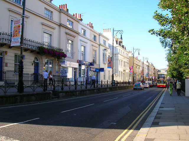
Windsor Terrace constructed in the 1830s. Unlike the slums Windsor Terrace still survives today as does the original walkway originally built next to a graveyard part of which survives to the right of the road today and is now a small park. The new road was built at a higher elevation than the old graveyard but lower than Windsor Terrace. The white building in the middle of the terrace is a Freemasons Lodge constructed in the 1920s. Click on the link to take you to the next page.
352:
285:
235:
277:
227:
299:
249:
320:
358:
363:
72:
828:"}},"text\/plain":{"en":{"":"heading"}}},"{\"value\":{\"amount\":\"+45\",\"unit\":\"http:\\\/\\\/www.wikidata.org\\\/entity\\\/Q28390\"},\"type\":\"quantity\"}":{"text\/html":{"en":{"P7787":"45
764:"}},"text\/plain":{"en":{"":"heading"}}},"{\"value\":{\"amount\":\"+45\",\"unit\":\"http:\\\/\\\/www.wikidata.org\\\/entity\\\/Q28390\"},\"type\":\"quantity\"}":{"text\/html":{"en":{"P7787":"45
824:
268:
983:== {{int:filedesc}} == {{Information |description={{en|1=Queens Road. Taken from the junction of Church Street and Queens Road. Queens Road was constructed in 1845 to connect Brighton town centre with the newly opened Brighton station. Parts of the route
218:
410:– You must give appropriate credit, provide a link to the license, and indicate if changes were made. You may do so in any reasonable manner, but not in any way that suggests the licensor endorses you or your use.
43:
825:
761:
83:
51:
1002:
696:
626:
590:
292:
242:
911:
716:
1190:
327:
1053:
This file contains additional information, probably added from the digital camera or scanner used to create or digitize it.
417:
553:
895:
866:
839:
802:
775:
724:
680:
574:
546:
533:
518:
739:
709:
646:
610:
491:
474:
997:
314:
1020:
373:
1159:
1056:
If the file has been modified from its original state, some details may not fully reflect the modified file.
965:
960:
42:
1209:
416:– If you remix, transform, or build upon the material, you must distribute your contributions under the
334:
on the
Geograph website for the photographer's contact details. The copyright on this image is owned by
976:
370:
1245:
832:"}},"text\/plain":{"en":{"P7787":"45 degree"}}}}": -->
768:"}},"text\/plain":{"en":{"P7787":"45 degree"}}}}": -->
91:
187:
746:
731:
525:
171:
298:
248:
1227:
1082:
339:
78:
1122:
1255:
139:
1102:
282:
232:
160:
150:
128:
1092:
319:
331:
933:
Click on a date/time to view the file as it appeared at that time.
1075:
1065:
284:
234:
259:
209:
66:
269:
50° 49′ 33″ N, 0° 08′ 31″ W
219:
50° 49′ 29″ N, 0° 08′ 38″ W
458:
Add a one-line explanation of what this file represents
1040:
1030:
110:
90:
Commons is a freely licensed media file repository.
627:
Creative
Commons Attribution-ShareAlike 2.0 Generic
56:(640 × 479 pixels, file size: 153 KB, MIME type:
427:https://creativecommons.org/licenses/by-sa/2.0
71:
433:Creative Commons Attribution-Share Alike 2.0
351:
8:
829:
765:
393:– to copy, distribute and transmit the work
1058:
935:
454:
116:Queens Road - geograph.org.uk - 212549.jpg
52:Queens_Road_-_geograph.org.uk_-_212549.jpg
1013:The following other wikis use this file:
747:https://www.geograph.org.uk/photo/212549
526:https://www.geograph.org.uk/profile/1833
129:https://www.geograph.org.uk/photo/212550
1253:
1243:
1235:
1225:
1217:
1207:
1199:
1188:
1180:
1172:
1164:
1154:
1146:
1138:
1130:
1119:
1111:
1100:
1090:
1080:
1070:
995:
909:
893:
853:
837:
789:
773:
694:
678:
660:
644:
624:
608:
588:
572:
505:
489:
472:
469:
450:
443:
262:
212:
291:View this and other nearby images on:
241:View this and other nearby images on:
1060:
993:The following 2 pages use this file:
7:
1003:Robert Hammond (electrical engineer)
338:and is licensed for reuse under the
924:
374:Attribution-Share Alike 2.0 Generic
362:
357:
342:Attribution-ShareAlike 2.0 license.
1051:
463:
457:
348:
325:
120:
103:
49:
1087:76,923/10,000,000 sec (0.0076923)
462:
1113:Date and time of data generation
776:coordinates of the point of view
448:
404:Under the following conditions:
369:This file is licensed under the
361:
356:
350:
318:
297:
283:
275:
247:
233:
225:
70:
31:
21:
445:
121:
46:No higher resolution available.
14:
697:file available on the internet
444:
326:This image was taken from the
26:
1:
1250:Flash did not fire, auto mode
840:coordinates of depicted place
36:
717:Geograph Britain and Ireland
547:object of statement has role
470:Items portrayed in this file
1201:Date and time of digitizing
1037:Usage on szl.wikipedia.org
1017:Usage on azb.wikipedia.org
998:Queen's Road, Brighton
274:
224:
1277:
1027:Usage on sl.wikipedia.org
418:same or compatible license
1166:File change date and time
925:
16:
855:50°49'32.5"N, 0°8'31.2"W
791:50°49'29.3"N, 0°8'38.4"W
725:geograph.org.uk image ID
447:
384:
200:Simon Carey /
181:Simon Carey /
77:This is a file from the
982:
172:required by the license
156:
145:
138:
135:
113:
81:. Information from its
1160:PictureProject 1.1.0 M
961:00:02, 1 February 2010
332:this photograph's page
303:50.825700; -0.142000
253:50.824800; -0.144000
84:description page there
1219:Maximum land aperture
1140:Horizontal resolution
1204:17:31, 30 July 2006
1174:Y and C positioning
1169:19:46, 30 July 2006
1148:Vertical resolution
1116:17:31, 30 July 2006
1062:Camera manufacturer
399:– to adapt the work
912:Nikon Coolpix 4600
534:author name string
1264:
1263:
1009:Global file usage
986:
831:
767:
611:copyright license
456:
347:
346:
330:collection. See
308:
307:
258:
257:
207:
206:
175:
99:
98:
79:Wikimedia Commons
32:Global file usage
1268:
1182:Exposure Program
1059:
973:
877:
876:
871:
813:
812:
807:
749:
744:
740:described at URL
734:
729:
719:
714:
575:copyright status
556:
551:
541:
538:
528:
523:
440:
437:
434:
431:
428:
420:as the original.
382:
371:Creative Commons
365:
364:
360:
359:
354:
353:
340:Creative Commons
328:Geograph project
322:
315:
304:
301:
287:
286:
280:
279:
278:
272:
271:
260:
254:
251:
237:
236:
230:
229:
228:
222:
221:
210:
169:
141:
125:
117:
111:
95:
74:
73:
67:
61:
59:
1276:
1275:
1271:
1270:
1269:
1267:
1266:
1265:
1222:3 APEX (f/2.83)
1047:
1007:
987:
979:
971:
927:
926:
923:
922:
921:
920:
919:
918:
917:
916:
914:
902:
901:
900:
898:
887:
886:
885:
884:
883:
882:
881:
880:
879:
878:
874:
872:
869:
860:
859:
858:
856:
846:
845:
844:
842:
823:
822:
821:
820:
819:
818:
817:
816:
815:
814:
810:
808:
805:
796:
795:
794:
792:
782:
781:
780:
778:
759:
758:
757:
756:
755:
754:
753:
752:
751:
750:
745:
742:
736:
735:
730:
727:
721:
720:
715:
712:
703:
702:
701:
699:
687:
686:
685:
683:
672:
671:
670:
669:
668:
667:
666:
665:
663:
653:
652:
651:
649:
638:
637:
636:
635:
634:
633:
632:
631:
629:
617:
616:
615:
613:
602:
601:
600:
599:
598:
597:
596:
595:
593:
581:
580:
579:
577:
566:
565:
564:
563:
562:
561:
560:
559:
558:
557:
552:
549:
543:
542:
539:
536:
530:
529:
524:
521:
512:
511:
510:
508:
498:
497:
496:
494:
483:
482:
481:
480:
479:
477:
461:
460:
459:
442:
441:
438:
435:
432:
429:
426:
425:
383:
380:
377:
366:
343:
313:
302:
276:
267:
266:
263:Object location
252:
226:
217:
216:
213:Camera location
208:
197:
190:
178:
151:geograph.org.uk
131:
115:
108:
101:
100:
89:
88:
87:is shown below.
63:
57:
55:
48:
47:
12:
11:
5:
1274:
1272:
1262:
1261:
1258:
1252:
1251:
1248:
1242:
1241:
1238:
1234:
1233:
1230:
1224:
1223:
1220:
1216:
1215:
1212:
1206:
1205:
1202:
1198:
1197:
1194:
1187:
1186:
1185:Normal program
1183:
1179:
1178:
1175:
1171:
1170:
1167:
1163:
1162:
1157:
1153:
1152:
1149:
1145:
1144:
1141:
1137:
1136:
1133:
1129:
1128:
1125:
1118:
1117:
1114:
1110:
1109:
1106:
1099:
1098:
1095:
1089:
1088:
1085:
1079:
1078:
1073:
1069:
1068:
1063:
1050:
1046:
1045:
1044:
1043:
1035:
1034:
1033:
1025:
1024:
1023:
1011:
1010:
1006:
1005:
1000:
991:
990:
985:
984:
981:
977:
974:
968:
963:
958:
954:
953:
950:
947:
944:
941:
938:
931:
930:
915:
910:
908:
907:
906:
905:
904:
903:
899:
894:
892:
891:
890:
889:
888:
865:
864:
863:
862:
861:
857:
854:
852:
851:
850:
849:
848:
847:
843:
838:
836:
835:
834:
833:
827:
801:
800:
799:
798:
797:
793:
790:
788:
787:
786:
785:
784:
783:
779:
774:
772:
771:
770:
769:
763:
738:
737:
723:
722:
708:
707:
706:
705:
704:
700:
695:
693:
692:
691:
690:
689:
688:
684:
681:source of file
679:
677:
676:
675:
674:
673:
664:
661:
659:
658:
657:
656:
655:
654:
650:
645:
643:
642:
641:
640:
639:
630:
625:
623:
622:
621:
620:
619:
618:
614:
609:
607:
606:
605:
604:
603:
594:
589:
587:
586:
585:
584:
583:
582:
578:
573:
571:
570:
569:
568:
567:
545:
544:
532:
531:
517:
516:
515:
514:
513:
509:
506:
504:
503:
502:
501:
500:
499:
495:
490:
488:
487:
486:
485:
484:
478:
473:
471:
468:
467:
466:
465:
464:
453:
452:
449:
446:
424:
423:
422:
421:
411:
402:
401:
400:
394:
387:You are free:
378:
368:
367:
349:
345:
344:
323:
312:
309:
306:
305:
295:
289:
264:
256:
255:
245:
239:
214:
205:
204:
198:
195:
192:
191:
186:
179:
176:
164:
163:
158:
154:
153:
147:
143:
142:
137:
133:
132:
118:
109:
107:
104:
102:
97:
96:
75:
65:
64:
45:
41:
40:
39:
34:
29:
24:
19:
13:
10:
9:
6:
4:
3:
2:
1273:
1259:
1257:
1254:
1249:
1247:
1244:
1239:
1236:
1231:
1229:
1228:Metering mode
1226:
1221:
1218:
1213:
1211:
1210:Exposure bias
1208:
1203:
1200:
1195:
1192:
1189:
1184:
1181:
1176:
1173:
1168:
1165:
1161:
1158:
1156:Software used
1155:
1150:
1147:
1142:
1139:
1134:
1131:
1126:
1124:
1120:
1115:
1112:
1107:
1104:
1101:
1096:
1094:
1091:
1086:
1084:
1083:Exposure time
1081:
1077:
1074:
1071:
1067:
1064:
1061:
1057:
1054:
1048:
1042:
1039:
1038:
1036:
1032:
1029:
1028:
1026:
1022:
1019:
1018:
1016:
1015:
1014:
1008:
1004:
1001:
999:
996:
994:
988:
980:
975:
969:
967:
964:
962:
959:
956:
955:
951:
948:
945:
942:
939:
937:
936:
934:
928:
913:
897:
896:captured with
868:
841:
804:
777:
748:
741:
733:
726:
718:
711:
698:
682:
648:
628:
612:
592:
576:
555:
548:
535:
527:
520:
493:
476:
430:CC BY-SA 2.0
419:
415:
412:
409:
406:
405:
403:
398:
395:
392:
389:
388:
386:
385:
379:Attribution:
375:
372:
355:
341:
337:
333:
329:
324:
321:
317:
316:
310:
300:
296:
294:
293:OpenStreetMap
290:
288:
270:
265:
261:
250:
246:
244:
243:OpenStreetMap
240:
238:
220:
215:
211:
203:
199:
194:
193:
189:
185: /
184:
180:
173:
168:
166:
165:
162:
159:
155:
152:
148:
144:
134:
130:
124:
119:
112:
105:
93:
86:
85:
80:
76:
69:
68:
62:
53:
44:
38:
35:
33:
30:
28:
25:
23:
20:
18:
15:
1237:Light source
1123:focal length
1072:Camera model
1055:
1052:
1021:کیلبرن، لندن
1012:
992:
932:
929:File history
662:30 July 2006
554:photographer
413:
407:
396:
390:
335:
273:
223:
201:
188:CC BY-SA 2.0
182:
140:30 July 2006
122:
92:You can help
82:
50:
22:File history
1256:Color space
1132:Orientation
978:GeographBot
591:copyrighted
540:Simon Carey
414:share alike
408:attribution
381:Simon Carey
336:Simon Carey
202:Queens Road
183:Queens Road
167:Attribution
161:Simon Carey
114:Description
989:File usage
970:640 × 479
946:Dimensions
507:some value
58:image/jpeg
27:File usage
1103:ISO speed
943:Thumbnail
940:Date/Time
647:inception
311:Licensing
196:InfoField
177:InfoField
123:English:
1177:Centered
1093:F-number
1049:Metadata
1041:Brighton
1031:Brighton
972:(153 KB)
710:operator
451:Captions
397:to remix
391:to share
376:license.
37:Metadata
1240:Unknown
1232:Pattern
1193:version
1151:300 dpi
1143:300 dpi
957:current
952:Comment
867:heading
826:heading
803:heading
762:heading
492:creator
475:depicts
455:English
106:Summary
54:
1135:Normal
1127:5.7 mm
1105:rating
875:degree
830:degree
811:degree
766:degree
732:212549
281:
231:
157:Author
146:Source
1246:Flash
1121:Lens
1097:f/4.9
1076:E4600
1066:NIKON
149:From
1260:sRGB
1191:Exif
949:User
439:true
436:true
136:Date
17:File
1196:2.2
873:45
809:45
519:URL
1108:50
870::
806::
743::
728::
713::
550::
537::
522::
1214:0
174:)
170:(
94:.
60:)
Text is available under the Creative Commons Attribution-ShareAlike License. Additional terms may apply.
_heading:45.00&language=en)
_heading:45.00&language=en)
