38:
238:
205:
219:
244:
249:
86:
652:
196:
97:
52:
48:
42:
65:
290:– You must give appropriate credit, provide a link to the license, and indicate if changes were made. You may do so in any reasonable manner, but not in any way that suggests the licensor endorses you or your use.
669:
Uploaded a work by OpenStreetMap contributors and SCHolar44 from
Background map: OpenStreetMap (https://www.openstreetmap.org/#map=14/-37.8391/144.9525&layers=H) Overlay:
687:
141:
651:
646:
56:
37:
346:"}},"text\/plain":{"en":{"P180":"Melbourne and Hobson's Bay Railway Company"}}}}": -->
495:
459:
212:
423:
389:
698:
This file contains additional information, probably added from the digital camera or scanner used to create or digitize it.
406:
297:
583:
549:
443:
372:
515:
479:
356:
259:
701:
If the file has been modified from its original state, some details may not fully reflect the modified file.
683:
The following pages on the
English Knowledge (XXG) use this file (pages on other projects are not listed):
296:– If you remix, transform, or build upon the material, you must distribute your contributions under the
165:
256:
105:
670:
662:
218:
92:
153:
202:
171:
338:
Route map of the former
Melbourne and Hobson's Bay Railway Company lines
130:
Route map of former
Melbourne and Hobson's Bay Railway Company lines.png
166:
https://www.openstreetmap.org/#map=14/-37.8391/144.9525&layers=H
619:
Click on a date/time to view the file as it appeared at that time.
204:
197:
37° 50′ 27.6″ S, 144° 55′ 57.36″ E
187:
80:
542:
496:
Creative
Commons Attribution-ShareAlike 4.0 International
124:
104:
Commons is a freely licensed media file repository.
70:(936 × 1,033 pixels, file size: 1.23 MB, MIME type:
688:Melbourne and Hobson's Bay Railway Company
307:https://creativecommons.org/licenses/by-sa/4.0
85:
313:Creative Commons Attribution-Share Alike 4.0
237:
8:
273:– to copy, distribute and transmit the work
703:
621:
424:Melbourne and Hobson's Bay Railway Company
334:
142:Melbourne and Hobson's Bay Railway Company
260:Attribution-Share Alike 4.0 International
181:OpenStreetMap contributors and SCHolar44
729:
721:
713:
705:
685:
597:
581:
563:
547:
529:
513:
493:
477:
457:
441:
421:
404:
387:
370:
354:
351:
330:
323:
190:
211:View this and other nearby images on:
7:
610:
248:
243:
696:
343:
337:
234:
134:
117:
63:
342:
550:coordinates of the point of view
328:
284:Under the following conditions:
255:This file is licensed under the
247:
242:
236:
217:
203:
84:
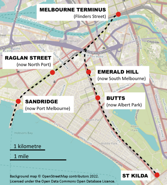
21:
325:
164:Background map: OpenStreetMap (
135:
14:
344:
26:
1:
31:
352:Items portrayed in this file
751:
298:same or compatible license
144:lines, Victoria, Australia
611:
16:
327:
264:
140:Route map of the former
91:This is a file from the
668:
565:37°50'28"S, 144°55'59"E
223:-37.841000; 144.932600
177:
159:
152:
149:
127:
95:. Information from its
98:description page there
41:Size of this preview:
723:Horizontal resolution
731:Vertical resolution
279:– to adapt the work
47:Other resolutions:
707:Compression scheme
647:07:04, 24 May 2022
57:936 × 1,033 pixels
738:
737:
715:Pixel composition
676:
673:with UploadWizard
480:copyright license
336:
228:
227:
185:
184:
113:
112:
93:Wikimedia Commons
742:
704:
659:
444:copyright status
320:
317:
314:
311:
308:
300:as the original.
257:Creative Commons
251:
250:
246:
245:
240:
239:
224:
221:
207:
206:
200:
199:
188:
155:
139:
131:
125:
109:
88:
87:
81:
75:
73:
60:
53:435 × 480 pixels
49:217 × 240 pixels
43:543 × 599 pixels
750:
749:
745:
744:
743:
741:
740:
739:
692:
684:
677:
665:
657:
613:
612:
609:
608:
607:
606:
605:
604:
603:
602:
600:
590:
589:
588:
586:
575:
574:
573:
572:
571:
570:
569:
568:
566:
556:
555:
554:
552:
541:
540:
539:
538:
537:
536:
535:
534:
532:
522:
521:
520:
518:
507:
506:
505:
504:
503:
502:
501:
500:
498:
486:
485:
484:
482:
471:
470:
469:
468:
467:
466:
465:
464:
462:
450:
449:
448:
446:
435:
434:
433:
432:
431:
430:
429:
428:
426:
415:
414:
413:
412:
411:
409:
398:
397:
396:
395:
394:
392:
390:South Melbourne
381:
380:
379:
378:
377:
375:
363:
362:
361:
359:
341:
340:
339:
322:
321:
318:
315:
312:
309:
306:
305:
263:
252:
233:
222:
195:
194:
191:Camera location
186:
145:
129:
122:
115:
114:
103:
102:
101:is shown below.
77:
71:
69:
62:
61:
46:
12:
11:
5:
748:
746:
736:
735:
732:
728:
727:
724:
720:
719:
716:
712:
711:
708:
695:
691:
690:
682:
681:
680:
675:
674:
667:
663:
660:
654:
649:
644:
640:
639:
636:
633:
630:
627:
624:
617:
616:
601:
598:
596:
595:
594:
593:
592:
591:
587:
582:
580:
579:
578:
577:
576:
567:
564:
562:
561:
560:
559:
558:
557:
553:
548:
546:
545:
544:
543:
533:
530:
528:
527:
526:
525:
524:
523:
519:
514:
512:
511:
510:
509:
508:
499:
494:
492:
491:
490:
489:
488:
487:
483:
478:
476:
475:
474:
473:
472:
463:
458:
456:
455:
454:
453:
452:
451:
447:
442:
440:
439:
438:
437:
436:
427:
422:
420:
419:
418:
417:
416:
410:
405:
403:
402:
401:
400:
399:
393:
388:
386:
385:
384:
383:
382:
376:
371:
369:
368:
367:
366:
365:
364:
360:
355:
353:
350:
349:
348:
347:
345:
333:
332:
329:
326:
304:
303:
302:
301:
291:
282:
281:
280:
274:
267:You are free:
254:
253:
235:
232:
229:
226:
225:
215:
209:
192:
183:
182:
179:
175:
174:
161:
157:
156:
151:
147:
146:
132:
123:
121:
118:
116:
111:
110:
89:
79:
78:
40:
36:
35:
34:
29:
24:
19:
13:
10:
9:
6:
4:
3:
2:
747:
733:
730:
725:
722:
717:
714:
709:
706:
702:
699:
693:
689:
686:
678:
672:
666:
661:
655:
653:
650:
648:
645:
642:
641:
637:
634:
631:
628:
625:
623:
622:
620:
614:
585:
551:
517:
497:
481:
461:
445:
425:
408:
391:
374:
358:
310:CC BY-SA 4.0
299:
295:
292:
289:
286:
285:
283:
278:
275:
272:
269:
268:
266:
265:
261:
258:
241:
230:
220:
216:
214:
213:OpenStreetMap
210:
208:
198:
193:
189:
180:
176:
173:
169:
167:
162:
158:
148:
143:
138:
133:
126:
119:
107:
100:
99:
94:
90:
83:
82:
76:
67:
66:Original file
58:
54:
50:
44:
39:
33:
30:
28:
25:
23:
20:
18:
15:
710:Uncompressed
700:
697:
656:936 × 1,033
618:
615:File history
293:
287:
276:
270:
163:
136:
106:You can help
96:
64:
22:File history
531:24 May 2022
460:copyrighted
407:Albert Park
294:share alike
288:attribution
154:24 May 2022
128:Description
679:File usage
632:Dimensions
584:media type
27:File usage
734:78.74 dpi
726:78.74 dpi
671:SCHolar44
664:SCHolar44
658:(1.23 MB)
629:Thumbnail
626:Date/Time
599:image/png
516:inception
231:Licensing
172:SCHolar44
170:Overlay:
137:English:
72:image/png
694:Metadata
331:Captions
277:to remix
271:to share
262:license.
32:Metadata
643:current
638:Comment
357:depicts
335:English
120:Summary
68:
201:
178:Author
160:Source
635:User
319:true
316:true
150:Date
17:File
718:RGB
373:map
168:)
55:|
51:|
45:.
108:.
74:)
59:.
Text is available under the Creative Commons Attribution-ShareAlike License. Additional terms may apply.
