301:
231:
223:
245:
269:
307:
312:
72:
749:"}},"text\/plain":{"en":{"":"heading"}}},"{\"value\":{\"amount\":\"+270\",\"unit\":\"http:\\\/\\\/www.wikidata.org\\\/entity\\\/Q28390\"},\"type\":\"quantity\"}":{"text\/html":{"en":{"P7787":"270
745:
214:
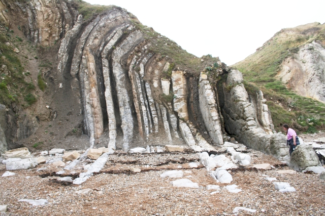
1046:== {{int:filedesc}} == {{Information |description={{en|1=Rock Strata, Durdle Door Layers of hard and soft sedimentary rocks upended. Some of the soft shales appear similar to the oil bearing "Grey wacky".}} |date=2006-10-27 |source=From [http://www.geogra
43:
359:– You must give appropriate credit, provide a link to the license, and indicate if changes were made. You may do so in any reasonable manner, but not in any way that suggests the licensor endorses you or your use.
83:
51:
746:
126:
Rock Strata, Durdle Door Layers of hard and soft sedimentary rocks upended. Some of the soft shales appear similar to the oil bearing "Grey wacky".
1093:
645:
575:
539:
238:
665:
1233:
276:
1106:
This file contains additional information, probably added from the digital camera or scanner used to create or digitize it.
974:
1028:
1023:
366:
42:
732:
502:
924:
887:
853:
816:
787:
760:
716:
673:
629:
523:
495:
482:
467:
688:
658:
595:
559:
440:
423:
958:
263:
322:
1109:
If the file has been modified from its original state, some details may not fully reflect the modified file.
1128:
1056:
The following pages on the
English Knowledge (XXG) use this file (pages on other projects are not listed):
1270:
365:– If you remix, transform, or build upon the material, you must distribute your contributions under the
283:
on the
Geograph website for the photographer's contact details. The copyright on this image is owned by
1039:
319:
753:"}},"text\/plain":{"en":{"P7787":"270 degree"}}}}": -->
1290:
91:
183:
1065:
1060:
695:
680:
167:
1118:
474:
244:
1350:
1280:
1252:
1135:
288:
78:
1175:
1300:
135:
1155:
228:
146:
156:
1145:
268:
280:
996:
Click on a date/time to view the file as it appeared at that time.
1228:
Landscape mode (for landscape photos with the background in focus)
230:
1083:
205:
66:
215:
50° 37′ 18″ N, 2° 16′ 30″ W
407:
Add a one-line explanation of what this file represents
116:
Rock Strata, Durdle Door - geograph.org.uk - 274762.jpg
52:
Rock_Strata,_Durdle_Door_-_geograph.org.uk_-_274762.jpg
110:
90:
Commons is a freely licensed media file repository.
576:
Creative
Commons Attribution-ShareAlike 2.0 Generic
56:(640 × 427 pixels, file size: 273 KB, MIME type:
1295:Flash did not fire, compulsory flash suppression
376:https://creativecommons.org/licenses/by-sa/2.0
71:
382:Creative Commons Attribution-Share Alike 2.0
300:
8:
750:
342:– to copy, distribute and transmit the work
1111:
998:
403:
1076:The following other wikis use this file:
696:https://www.geograph.org.uk/photo/274762
1358:
1348:
1340:
1332:
1324:
1316:
1308:
1298:
1288:
1278:
1268:
1260:
1250:
1242:
1231:
1223:
1215:
1207:
1199:
1191:
1183:
1172:
1164:
1153:
1143:
1133:
1123:
1058:
972:
956:
938:
922:
901:
885:
867:
851:
830:
814:
774:
758:
730:
714:
643:
627:
609:
593:
573:
557:
537:
521:
475:https://www.geograph.org.uk/profile/125
454:
438:
421:
418:
399:
392:
208:
237:View this and other nearby images on:
1113:
7:
287:and is licensed for reuse under the
987:
323:Attribution-Share Alike 2.0 Generic
311:
306:
291:Attribution-ShareAlike 2.0 license.
1104:
412:
406:
297:
274:
120:
103:
49:
411:
1166:Date and time of data generation
397:
353:Under the following conditions:
318:This file is licensed under the
310:
305:
299:
267:
243:
229:
221:
70:
31:
21:
394:
121:
46:No higher resolution available.
14:
646:file available on the internet
393:
275:This image was taken from the
26:
1:
761:coordinates of depicted place
36:
666:Geograph Britain and Ireland
496:object of statement has role
419:Items portrayed in this file
220:
1326:Focal plane resolution unit
1244:Date and time of digitizing
1380:
1090:Usage on hy.wikipedia.org
1080:Usage on ca.wikipedia.org
367:same or compatible license
1209:File change date and time
988:
776:50°37'17.8"N, 2°16'30.0"W
196:Bob Embleton /
177:Bob Embleton /
16:
1318:Focal plane Y resolution
1310:Focal plane X resolution
674:geograph.org.uk image ID
396:
333:
198:Rock Strata, Durdle Door
179:Rock Strata, Durdle Door
77:This is a file from the
1334:Custom image processing
1045:
1024:20:13, 12 December 2010
168:required by the license
152:
141:
134:
131:
113:
81:. Information from its
1247:14:42, 27 October 2006
1212:14:42, 27 October 2006
1169:14:42, 27 October 2006
1129:Canon EOS 350D DIGITAL
281:this photograph's page
249:50.621600; -2.275000
84:description page there
1193:Horizontal resolution
1217:Y and C positioning
1201:Vertical resolution
1115:Camera manufacturer
348:– to adapt the work
1360:Scene capture type
1355:Auto white balance
483:author name string
1367:
1366:
1140:1/125 sec (0.008)
1084:Estrat (geologia)
1072:Global file usage
1066:Purbeck Monocline
1061:Geology of Dorset
1049:
752:
560:copyright license
405:
296:
295:
279:collection. See
254:
253:
203:
202:
171:
99:
98:
79:Wikimedia Commons
32:Global file usage
1371:
1321:3,958.7628865979
1225:Exposure Program
1112:
1094:Նավթաբեր ապարներ
1036:
906:
835:
798:
797:
792:
698:
693:
689:described at URL
683:
678:
668:
663:
524:copyright status
505:
500:
490:
487:
477:
472:
389:
386:
383:
380:
377:
369:as the original.
331:
320:Creative Commons
314:
313:
309:
308:
303:
302:
289:Creative Commons
277:Geograph project
271:
264:
250:
247:
233:
232:
226:
225:
224:
218:
217:
206:
165:
137:
125:
117:
111:
95:
74:
73:
67:
61:
59:
1379:
1378:
1374:
1373:
1372:
1370:
1369:
1368:
1313:3,954.233409611
1265:5.3106994628906
1257:6.9657897949219
1100:
1070:
1057:
1050:
1042:
1034:
990:
989:
986:
985:
984:
983:
982:
981:
980:
979:
977:
965:
964:
963:
961:
950:
949:
948:
947:
946:
945:
944:
943:
941:
931:
930:
929:
927:
916:
915:
914:
913:
912:
911:
910:
909:
907:
904:
894:
893:
892:
890:
879:
878:
877:
876:
875:
874:
873:
872:
870:
860:
859:
858:
856:
845:
844:
843:
842:
841:
840:
839:
838:
836:
833:
823:
822:
821:
819:
808:
807:
806:
805:
804:
803:
802:
801:
800:
799:
795:
793:
790:
781:
780:
779:
777:
767:
766:
765:
763:
744:
743:
742:
741:
740:
739:
738:
737:
735:
723:
722:
721:
719:
708:
707:
706:
705:
704:
703:
702:
701:
700:
699:
694:
691:
685:
684:
679:
676:
670:
669:
664:
661:
652:
651:
650:
648:
636:
635:
634:
632:
621:
620:
619:
618:
617:
616:
615:
614:
612:
611:27 October 2006
602:
601:
600:
598:
587:
586:
585:
584:
583:
582:
581:
580:
578:
566:
565:
564:
562:
551:
550:
549:
548:
547:
546:
545:
544:
542:
530:
529:
528:
526:
515:
514:
513:
512:
511:
510:
509:
508:
507:
506:
501:
498:
492:
491:
488:
485:
479:
478:
473:
470:
461:
460:
459:
457:
447:
446:
445:
443:
432:
431:
430:
429:
428:
426:
410:
409:
408:
391:
390:
387:
384:
381:
378:
375:
374:
332:
329:
326:
315:
292:
262:
248:
222:
213:
212:
209:Object location
204:
193:
186:
174:
147:geograph.org.uk
136:27 October 2006
127:
115:
108:
101:
100:
89:
88:
87:is shown below.
63:
57:
55:
48:
47:
12:
11:
5:
1377:
1375:
1365:
1364:
1361:
1357:
1356:
1353:
1347:
1346:
1343:
1339:
1338:
1337:Normal process
1335:
1331:
1330:
1327:
1323:
1322:
1319:
1315:
1314:
1311:
1307:
1306:
1303:
1297:
1296:
1293:
1287:
1286:
1283:
1277:
1276:
1273:
1267:
1266:
1263:
1259:
1258:
1255:
1249:
1248:
1245:
1241:
1240:
1237:
1230:
1229:
1226:
1222:
1221:
1218:
1214:
1213:
1210:
1206:
1205:
1202:
1198:
1197:
1194:
1190:
1189:
1186:
1182:
1181:
1178:
1171:
1170:
1167:
1163:
1162:
1159:
1152:
1151:
1148:
1142:
1141:
1138:
1132:
1131:
1126:
1122:
1121:
1116:
1103:
1099:
1098:
1097:
1096:
1088:
1087:
1086:
1074:
1073:
1069:
1068:
1063:
1055:
1054:
1053:
1048:
1047:
1044:
1040:
1037:
1031:
1026:
1021:
1017:
1016:
1013:
1010:
1007:
1004:
1001:
994:
993:
978:
973:
971:
970:
969:
968:
967:
966:
962:
957:
955:
954:
953:
952:
951:
942:
939:
937:
936:
935:
934:
933:
932:
928:
923:
921:
920:
919:
918:
917:
908:
902:
900:
899:
898:
897:
896:
895:
891:
886:
884:
883:
882:
881:
880:
871:
868:
866:
865:
864:
863:
862:
861:
857:
852:
850:
849:
848:
847:
846:
837:
831:
829:
828:
827:
826:
825:
824:
820:
815:
813:
812:
811:
810:
809:
786:
785:
784:
783:
782:
778:
775:
773:
772:
771:
770:
769:
768:
764:
759:
757:
756:
755:
754:
748:
736:
733:Canon EOS 350D
731:
729:
728:
727:
726:
725:
724:
720:
715:
713:
712:
711:
710:
709:
687:
686:
672:
671:
657:
656:
655:
654:
653:
649:
644:
642:
641:
640:
639:
638:
637:
633:
630:source of file
628:
626:
625:
624:
623:
622:
613:
610:
608:
607:
606:
605:
604:
603:
599:
594:
592:
591:
590:
589:
588:
579:
574:
572:
571:
570:
569:
568:
567:
563:
558:
556:
555:
554:
553:
552:
543:
538:
536:
535:
534:
533:
532:
531:
527:
522:
520:
519:
518:
517:
516:
494:
493:
481:
480:
466:
465:
464:
463:
462:
458:
455:
453:
452:
451:
450:
449:
448:
444:
439:
437:
436:
435:
434:
433:
427:
422:
420:
417:
416:
415:
414:
413:
402:
401:
398:
395:
373:
372:
371:
370:
360:
351:
350:
349:
343:
336:You are free:
327:
317:
316:
298:
294:
293:
272:
261:
258:
252:
251:
241:
235:
210:
201:
200:
194:
191:
188:
187:
182:
175:
172:
160:
159:
154:
150:
149:
143:
139:
138:
133:
129:
128:
118:
109:
107:
104:
102:
97:
96:
75:
65:
64:
45:
41:
40:
39:
34:
29:
24:
19:
13:
10:
9:
6:
4:
3:
2:
1376:
1362:
1359:
1354:
1352:
1351:White balance
1349:
1345:Auto exposure
1344:
1342:Exposure mode
1341:
1336:
1333:
1328:
1325:
1320:
1317:
1312:
1309:
1304:
1302:
1299:
1294:
1292:
1289:
1284:
1282:
1281:Metering mode
1279:
1274:
1272:
1271:Exposure bias
1269:
1264:
1262:APEX aperture
1261:
1256:
1254:
1253:Shutter speed
1251:
1246:
1243:
1238:
1235:
1232:
1227:
1224:
1219:
1216:
1211:
1208:
1203:
1200:
1195:
1192:
1187:
1184:
1179:
1177:
1173:
1168:
1165:
1160:
1157:
1154:
1149:
1147:
1144:
1139:
1137:
1136:Exposure time
1134:
1130:
1127:
1124:
1120:
1117:
1114:
1110:
1107:
1101:
1095:
1092:
1091:
1089:
1085:
1082:
1081:
1079:
1078:
1077:
1071:
1067:
1064:
1062:
1059:
1051:
1043:
1038:
1032:
1030:
1027:
1025:
1022:
1019:
1018:
1014:
1011:
1008:
1005:
1002:
1000:
999:
997:
991:
976:
960:
926:
889:
855:
818:
817:exposure time
789:
762:
734:
718:
717:captured with
697:
690:
682:
675:
667:
660:
647:
631:
597:
577:
561:
541:
525:
504:
497:
484:
476:
469:
442:
425:
379:CC BY-SA 2.0
368:
364:
361:
358:
355:
354:
352:
347:
344:
341:
338:
337:
335:
334:
328:Attribution:
324:
321:
304:
290:
286:
282:
278:
273:
270:
266:
265:
259:
257:
256:
246:
242:
240:
239:OpenStreetMap
236:
234:
216:
211:
207:
199:
195:
190:
189:
185:
181: /
180:
176:
169:
164:
162:
161:
158:
155:
151:
148:
144:
140:
130:
124:
119:
112:
105:
93:
86:
85:
80:
76:
69:
68:
62:
53:
44:
38:
35:
33:
30:
28:
25:
23:
20:
18:
15:
1176:focal length
1125:Camera model
1108:
1105:
1075:
995:
992:File history
888:focal length
503:photographer
489:Bob Embleton
362:
356:
345:
339:
330:Bob Embleton
285:Bob Embleton
284:
255:
219:
197:
184:CC BY-SA 2.0
178:
157:Bob Embleton
122:
92:You can help
82:
50:
22:File history
1301:Color space
1185:Orientation
1041:GeographBot
959:instance of
540:copyrighted
363:share alike
357:attribution
163:Attribution
114:Description
1052:File usage
1033:640 × 427
1009:Dimensions
975:photograph
905:millimetre
456:some value
58:image/jpeg
27:File usage
1156:ISO speed
1006:Thumbnail
1003:Date/Time
925:ISO speed
596:inception
260:Licensing
192:InfoField
173:InfoField
123:English:
1363:Standard
1220:Co-sited
1146:F-number
1102:Metadata
1035:(273 KB)
854:f-number
659:operator
400:Captions
346:to remix
340:to share
325:license.
37:Metadata
1285:Pattern
1236:version
1020:current
1015:Comment
788:heading
747:heading
441:creator
424:depicts
404:English
106:Summary
54:
1329:inches
1204:72 dpi
1196:72 dpi
1188:Normal
1158:rating
834:second
832:0.008
796:degree
751:degree
681:274762
227:
153:Author
142:Source
1291:Flash
1180:18 mm
1174:Lens
1150:f/6.3
1119:Canon
145:From
1305:sRGB
1239:2.21
1234:Exif
1012:User
794:270
388:true
385:true
132:Date
17:File
1161:100
940:100
903:18
869:6.3
468:URL
791::
692::
677::
662::
499::
486::
471::
1275:0
170:)
166:(
94:.
60:)
Text is available under the Creative Commons Attribution-ShareAlike License. Additional terms may apply.
_heading:270.00&language=en)
