349:
282:
232:
274:
224:
296:
246:
317:
355:
360:
72:
825:"}},"text\/plain":{"en":{"":"heading"}}},"{\"value\":{\"amount\":\"+157\",\"unit\":\"http:\\\/\\\/www.wikidata.org\\\/entity\\\/Q28390\"},\"type\":\"quantity\"}":{"text\/html":{"en":{"P7787":"157
761:"}},"text\/plain":{"en":{"":"heading"}}},"{\"value\":{\"amount\":\"+157\",\"unit\":\"http:\\\/\\\/www.wikidata.org\\\/entity\\\/Q28390\"},\"type\":\"quantity\"}":{"text\/html":{"en":{"P7787":"157
821:
265:
944:== {{int:filedesc}} == {{Information |description={{en|1=Rack Marsh, Bagnor Watermeadows where the River Lambourn and Winterbourne Stream have their confluence. The marsh is a Wildlife Trust nature reserve. It is crossed by a byway which is, in reality, j
215:
126:
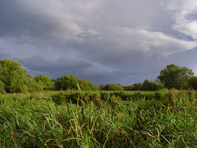
Rack Marsh, Bagnor
Watermeadows where the River Lambourn and Winterbourne Stream have their confluence. The marsh is a Wildlife Trust nature reserve. It is crossed by a byway which is, in reality, just a very swampy footpath with footbridges over the
43:
407:– You must give appropriate credit, provide a link to the license, and indicate if changes were made. You may do so in any reasonable manner, but not in any way that suggests the licensor endorses you or your use.
968:
958:
83:
51:
822:
758:
1118:
693:
623:
587:
289:
239:
743:
1149:
963:
324:
1004:
This file contains additional information, probably added from the digital camera or scanner used to create or digitize it.
414:
522:
863:
836:
799:
772:
721:
677:
571:
545:
530:
515:
736:
706:
643:
607:
488:
471:
926:
921:
42:
311:
370:
1007:
If the file has been modified from its original state, some details may not fully reflect the modified file.
1192:
413:– If you remix, transform, or build upon the material, you must distribute your contributions under the
331:
on the
Geograph website for the photographer's contact details. The copyright on this image is owned by
937:
367:
829:"}},"text\/plain":{"en":{"P7787":"157 degree"}}}}": -->
765:"}},"text\/plain":{"en":{"P7787":"157 degree"}}}}": -->
1228:
91:
184:
1026:
991:
728:
713:
537:
168:
295:
245:
1256:
1210:
1041:
336:
78:
1081:
1238:
136:
1061:
973:
279:
229:
157:
147:
1274:
1051:
316:
328:
894:
Click on a date/time to view the file as it appeared at that time.
1016:
281:
231:
256:
206:
66:
969:
List of Sites of
Special Scientific Interest in Berkshire
959:
Berkshire, Buckinghamshire and
Oxfordshire Wildlife Trust
266:
51° 25′ 13″ N, 1° 21′ 01″ W
216:
51° 25′ 15″ N, 1° 21′ 03″ W
455:
Add a one-line explanation of what this file represents
110:
90:
Commons is a freely licensed media file repository.
624:
Creative
Commons Attribution-ShareAlike 2.0 Generic
116:Rack Marsh, Bagnor - geograph.org.uk - 925042.jpg
56:(640 × 480 pixels, file size: 154 KB, MIME type:
52:Rack_Marsh,_Bagnor_-_geograph.org.uk_-_925042.jpg
1233:Flash did not fire, compulsory flash suppression
992:Plaine inondable de la Kennet et de la Lambourn
424:https://creativecommons.org/licenses/by-sa/2.0
71:
430:Creative Commons Attribution-Share Alike 2.0
348:
8:
826:
762:
390:– to copy, distribute and transmit the work
1009:
896:
451:
984:The following other wikis use this file:
714:https://www.geograph.org.uk/photo/925042
538:https://www.geograph.org.uk/profile/2562
1272:
1264:
1254:
1246:
1236:
1226:
1218:
1208:
1200:
1190:
1182:
1174:
1166:
1158:
1147:
1139:
1131:
1123:
1113:
1105:
1097:
1089:
1078:
1070:
1059:
1049:
1039:
1031:
1021:
956:
850:
834:
786:
770:
691:
675:
657:
641:
621:
605:
585:
569:
502:
486:
469:
466:
447:
440:
259:
209:
288:View this and other nearby images on:
238:View this and other nearby images on:
1011:
954:The following 4 pages use this file:
7:
1119:Adobe Photoshop Elements 3.0 Windows
335:and is licensed for reuse under the
885:
371:Attribution-Share Alike 2.0 Generic
359:
354:
339:Attribution-ShareAlike 2.0 license.
1002:
460:
454:
345:
322:
120:
103:
49:
459:
1072:Date and time of data generation
773:coordinates of the point of view
445:
401:Under the following conditions:
366:This file is licensed under the
358:
353:
347:
315:
294:
280:
272:
244:
230:
222:
70:
31:
21:
442:
121:
46:No higher resolution available.
14:
1046:1/760 sec (0.0013157894736842)
964:Kennet and Lambourn Floodplain
694:file available on the internet
441:
323:This image was taken from the
26:
1:
837:coordinates of depicted place
36:
744:Geograph Britain and Ireland
516:object of statement has role
467:Items portrayed in this file
271:
221:
1160:Date and time of digitizing
1296:
988:Usage on fr.wikipedia.org
852:51°25'13.19"N, 1°21'1.08"W
788:51°25'15.46"N, 1°21'2.88"W
415:same or compatible license
1125:File change date and time
1036:(C) by Caplio R4 User
886:
197:Andrew Smith /
178:Andrew Smith /
16:
722:geograph.org.uk image ID
444:
381:
77:This is a file from the
943:
922:03:44, 22 February 2011
169:required by the license
153:
142:
135:
132:
113:
81:. Information from its
1168:Image compression mode
329:this photograph's page
300:51.420330; -1.350300
250:51.420960; -1.350800
84:description page there
1202:Maximum land aperture
1163:17:40, 12 August 2008
1128:04:19, 17 August 2008
1099:Horizontal resolution
1075:17:40, 12 August 2008
1133:Y and C positioning
1107:Vertical resolution
1013:Camera manufacturer
396:– to adapt the work
1266:Scene capture type
1261:Auto white balance
546:author name string
199:Rack Marsh, Bagnor
180:Rack Marsh, Bagnor
1283:
1282:
1205:3.3 APEX (f/3.14)
980:Global file usage
947:
828:
764:
608:copyright license
453:
344:
343:
327:collection. See
305:
304:
255:
254:
204:
203:
172:
99:
98:
79:Wikimedia Commons
32:Global file usage
1287:
1141:Exposure Program
1033:Copyright holder
1010:
934:
874:
873:
868:
810:
809:
804:
746:
741:
731:
726:
716:
711:
707:described at URL
572:copyright status
553:
550:
540:
535:
525:
520:
437:
434:
431:
428:
425:
417:as the original.
379:
368:Creative Commons
362:
361:
357:
356:
351:
350:
337:Creative Commons
325:Geograph project
319:
312:
301:
298:
284:
283:
277:
276:
275:
269:
268:
257:
251:
248:
234:
233:
227:
226:
225:
219:
218:
207:
166:
138:
125:
117:
111:
95:
74:
73:
67:
61:
59:
1295:
1294:
1290:
1289:
1288:
1286:
1285:
1284:
1184:APEX brightness
1027:Caplio R4
998:
978:
948:
940:
932:
888:
887:
884:
883:
882:
881:
880:
879:
878:
877:
876:
875:
871:
869:
866:
857:
856:
855:
853:
843:
842:
841:
839:
820:
819:
818:
817:
816:
815:
814:
813:
812:
811:
807:
805:
802:
793:
792:
791:
789:
779:
778:
777:
775:
756:
755:
754:
753:
752:
751:
750:
749:
748:
747:
742:
739:
733:
732:
727:
724:
718:
717:
712:
709:
700:
699:
698:
696:
684:
683:
682:
680:
669:
668:
667:
666:
665:
664:
663:
662:
660:
650:
649:
648:
646:
635:
634:
633:
632:
631:
630:
629:
628:
626:
614:
613:
612:
610:
599:
598:
597:
596:
595:
594:
593:
592:
590:
578:
577:
576:
574:
563:
562:
561:
560:
559:
558:
557:
556:
555:
554:
551:
548:
542:
541:
536:
533:
527:
526:
521:
518:
509:
508:
507:
505:
495:
494:
493:
491:
480:
479:
478:
477:
476:
474:
458:
457:
456:
439:
438:
435:
432:
429:
426:
423:
422:
380:
377:
374:
363:
340:
310:
299:
273:
264:
263:
260:Object location
249:
223:
214:
213:
210:Camera location
205:
194:
187:
175:
148:geograph.org.uk
128:
115:
108:
101:
100:
89:
88:
87:is shown below.
63:
57:
55:
48:
47:
12:
11:
5:
1293:
1291:
1281:
1280:
1277:
1271:
1270:
1267:
1263:
1262:
1259:
1253:
1252:
1249:
1245:
1244:
1241:
1235:
1234:
1231:
1225:
1224:
1221:
1217:
1216:
1213:
1207:
1206:
1203:
1199:
1198:
1195:
1189:
1188:
1185:
1181:
1180:
1177:
1173:
1172:
1169:
1165:
1164:
1161:
1157:
1156:
1153:
1146:
1145:
1144:Normal program
1142:
1138:
1137:
1134:
1130:
1129:
1126:
1122:
1121:
1116:
1112:
1111:
1108:
1104:
1103:
1100:
1096:
1095:
1092:
1088:
1087:
1084:
1077:
1076:
1073:
1069:
1068:
1065:
1058:
1057:
1054:
1048:
1047:
1044:
1038:
1037:
1034:
1030:
1029:
1024:
1020:
1019:
1014:
1001:
997:
996:
995:
994:
982:
981:
977:
976:
971:
966:
961:
952:
951:
946:
945:
942:
938:
935:
929:
924:
919:
915:
914:
911:
908:
905:
902:
899:
892:
891:
862:
861:
860:
859:
858:
854:
851:
849:
848:
847:
846:
845:
844:
840:
835:
833:
832:
831:
830:
824:
798:
797:
796:
795:
794:
790:
787:
785:
784:
783:
782:
781:
780:
776:
771:
769:
768:
767:
766:
760:
735:
734:
720:
719:
705:
704:
703:
702:
701:
697:
692:
690:
689:
688:
687:
686:
685:
681:
678:source of file
676:
674:
673:
672:
671:
670:
661:
659:12 August 2008
658:
656:
655:
654:
653:
652:
651:
647:
642:
640:
639:
638:
637:
636:
627:
622:
620:
619:
618:
617:
616:
615:
611:
606:
604:
603:
602:
601:
600:
591:
586:
584:
583:
582:
581:
580:
579:
575:
570:
568:
567:
566:
565:
564:
544:
543:
529:
528:
514:
513:
512:
511:
510:
506:
503:
501:
500:
499:
498:
497:
496:
492:
487:
485:
484:
483:
482:
481:
475:
470:
468:
465:
464:
463:
462:
461:
450:
449:
446:
443:
421:
420:
419:
418:
408:
399:
398:
397:
391:
384:You are free:
375:
365:
364:
346:
342:
341:
320:
309:
306:
303:
302:
292:
286:
261:
253:
252:
242:
236:
211:
202:
201:
195:
192:
189:
188:
183:
176:
173:
161:
160:
155:
151:
150:
144:
140:
139:
137:12 August 2008
134:
130:
129:
118:
109:
107:
104:
102:
97:
96:
75:
65:
64:
45:
41:
40:
39:
34:
29:
24:
19:
13:
10:
9:
6:
4:
3:
2:
1292:
1278:
1276:
1273:
1268:
1265:
1260:
1258:
1257:White balance
1255:
1251:Auto exposure
1250:
1248:Exposure mode
1247:
1242:
1240:
1237:
1232:
1230:
1227:
1222:
1219:
1214:
1212:
1211:Metering mode
1209:
1204:
1201:
1196:
1194:
1193:Exposure bias
1191:
1186:
1183:
1178:
1176:APEX aperture
1175:
1170:
1167:
1162:
1159:
1154:
1151:
1148:
1143:
1140:
1135:
1132:
1127:
1124:
1120:
1117:
1115:Software used
1114:
1109:
1106:
1101:
1098:
1093:
1090:
1085:
1083:
1079:
1074:
1071:
1066:
1063:
1060:
1055:
1053:
1050:
1045:
1043:
1042:Exposure time
1040:
1035:
1032:
1028:
1025:
1022:
1018:
1015:
1012:
1008:
1005:
999:
993:
990:
989:
987:
986:
985:
979:
975:
972:
970:
967:
965:
962:
960:
957:
955:
949:
941:
936:
930:
928:
925:
923:
920:
917:
916:
912:
909:
906:
903:
900:
898:
897:
895:
889:
865:
838:
801:
774:
745:
738:
730:
723:
715:
708:
695:
679:
645:
625:
609:
589:
573:
547:
539:
532:
524:
517:
490:
473:
427:CC BY-SA 2.0
416:
412:
409:
406:
403:
402:
400:
395:
392:
389:
386:
385:
383:
382:
376:Attribution:
372:
369:
352:
338:
334:
330:
326:
321:
318:
314:
313:
307:
297:
293:
291:
290:OpenStreetMap
287:
285:
267:
262:
258:
247:
243:
241:
240:OpenStreetMap
237:
235:
217:
212:
208:
200:
196:
191:
190:
186:
182: /
181:
177:
170:
165:
163:
162:
159:
156:
152:
149:
145:
141:
131:
127:watercourses.
124:
119:
112:
105:
93:
86:
85:
80:
76:
69:
68:
62:
53:
44:
38:
35:
33:
30:
28:
25:
23:
20:
18:
15:
1220:Light source
1082:focal length
1023:Camera model
1006:
1003:
983:
953:
893:
890:File history
552:Andrew Smith
523:photographer
410:
404:
393:
387:
378:Andrew Smith
333:Andrew Smith
332:
270:
220:
198:
185:CC BY-SA 2.0
179:
158:Andrew Smith
122:
92:You can help
82:
50:
22:File history
1239:Color space
1091:Orientation
1017:RICOH
939:GeographBot
588:copyrighted
411:share alike
405:attribution
164:Attribution
114:Description
974:Rack Marsh
950:File usage
931:640 × 480
907:Dimensions
504:some value
58:image/jpeg
27:File usage
1275:Sharpness
1062:ISO speed
904:Thumbnail
901:Date/Time
644:inception
308:Licensing
193:InfoField
174:InfoField
123:English:
1269:Standard
1136:Co-sited
1052:F-number
1000:Metadata
933:(154 KB)
737:operator
448:Captions
394:to remix
388:to share
373:license.
37:Metadata
1223:Unknown
1215:Pattern
1152:version
918:current
913:Comment
864:heading
823:heading
800:heading
759:heading
489:creator
472:depicts
452:English
106:Summary
54:
1279:Normal
1110:72 dpi
1102:72 dpi
1094:Normal
1086:5.2 mm
1064:rating
872:degree
827:degree
808:degree
763:degree
729:925042
278:
228:
154:Author
143:Source
1229:Flash
1080:Lens
1056:f/3.6
146:From
1243:sRGB
1155:2.21
1150:Exif
910:User
870:157
806:157
436:true
433:true
133:Date
17:File
1187:6.4
1179:3.7
1171:2.8
1067:100
531:URL
867::
803::
740::
725::
710::
549::
534::
519::
1197:0
171:)
167:(
94:.
60:)
Text is available under the Creative Commons Attribution-ShareAlike License. Additional terms may apply.
_heading:157.00&language=en)
_heading:157.00&language=en)
