38:
285:
291:
403:
296:
94:
984:
954:
924:
337:– You must give appropriate credit, provide a link to the license, and indicate if changes were made. You may do so in any reasonable manner, but not in any way that suggests the licensor endorses you or your use.
1001:{{Information |Description={{en|1=Railway Map Germany: Magdeburg-Wittenberge}} {{de|1=Eisenbahnstrecke Magdeburg-Wittenberge}} |Source={{de|Eigene Arbeit, basiert auf}} {{en|Own work, based on}} *
60:
56:
52:
48:
42:
105:
73:
417:
269:
1047:
983:
978:
953:
948:
835:
799:
344:
1019:
1002:
783:
755:
742:
727:
855:
819:
700:
683:
188:
306:
642:
734:
410:
343:– If you remix, transform, or build upon the material, you must distribute your contributions under the
923:
918:
64:
37:
303:
113:
1062:
230:
This map may be incomplete, and may contain errors. Don't rely solely on it for navigation.
762:
402:
192:
1042:
1052:
1048:
Knowledge:Kartenwerkstatt/Hilfe/Erstellung von
Bahnkarten auf Basis von OpenStreetMap
277:
100:
452:
378:
225:
160:
560:
524:
632:
623:
614:
605:
596:
587:
578:
569:
551:
542:
533:
515:
506:
497:
488:
479:
470:
461:
443:
434:
425:
994:
964:
934:
204:
213:
891:
Click on a date/time to view the file as it appeared at that time.
1037:
971:
Platzierung der Orte, zusätzliche Bahnhöfe, Farbgebung, M;aßstab
248:
88:
941:
letzte
Korrekturen (s. Diskussion in der Kartenwerkstatt)
453:
667:
Add a one-line explanation of what this file represents
387:
If inappropriate please set warp_status = skip to hide.
78:(2,024 × 2,500 pixels, file size: 2.31 MB, MIME type:
1072:
397:
127:
112:
Commons is a freely licensed media file repository.
836:
Creative
Commons Attribution-ShareAlike 2.0 Generic
561:
525:
280:Attribution-ShareAlike 2.0 license (CC-BY-SA 2.0).
276:OpenStreetMap data and maps are licensed under the
633:
624:
615:
606:
597:
588:
579:
570:
552:
543:
534:
516:
507:
498:
489:
480:
471:
462:
444:
435:
426:
409:This map has been made or improved in the German
354:https://creativecommons.org/licenses/by-sa/2.0
93:
360:Creative Commons Attribution-Share Alike 2.0
284:
8:
320:– to copy, distribute and transmit the work
893:
663:
641:
228:project data, collected by the community.
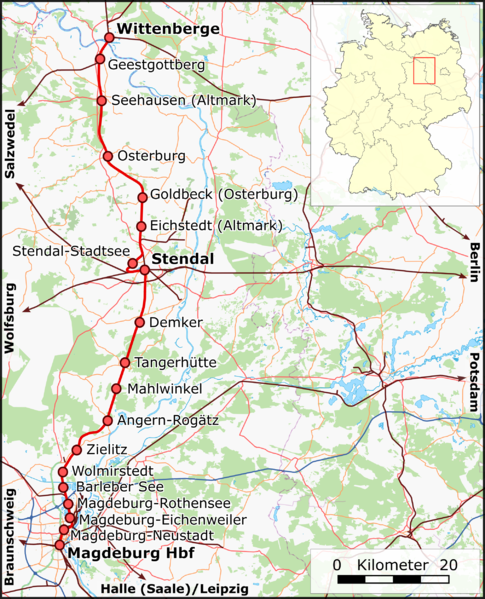
143:Railway Map Germany: Magdeburg-Wittenberge
1030:The following other wikis use this file:
1053:Knowledge:Kartenwerkstatt/Archiv/2010-06
1017:
869:
853:
833:
817:
797:
781:
763:https://commons.wikimedia.org/user:Muns
714:
698:
681:
678:
659:
652:
381:Georeference the map in Wikimaps Warper
1063:Linia kolejowa Magdeburg – Wittenberge
151:Eisenbahnstrecke Magdeburg-Wittenberge
219:Railway Map Magdeburg-Wittenberge.png
133:Railway Map Magdeburg-Wittenberge.png
7:
1015:The following page uses this file:
882:
307:Attribution-Share Alike 2.0 Generic
295:
290:
672:
666:
408:
281:
178:
170:
145:
137:
125:
71:
1043:Bahnstrecke Magdeburg–Wittenberge
671:
657:
401:
331:Under the following conditions:
302:This file is licensed under the
294:
289:
283:
92:
31:
21:
654:
179:
138:
14:
653:
171:
146:
26:
1:
1020:Magdeburg-Wittenberge railway
1003:File:Germany location map.svg
379:
189:File:Germany location map.svg
679:Items portrayed in this file
224:This map was created from
1091:
1069:Usage on www.wikidata.org
1059:Usage on pl.wikipedia.org
1034:Usage on de.wikipedia.org
345:same or compatible license
259:OpenStreetMap contributors
1005:, by [[User:NordNordWest|
883:
16:
656:
311:
99:This is a file from the
1000:
970:
940:
373:
264:
254:
244:
236:
216:
200:
166:
159:
156:
130:
103:. Information from its
106:description page there
41:Size of this preview:
1038:Benutzer:Muns/Bilder
420:to improve as well.
176:Eigene Arbeit, nutzt
65:2,024 × 2,500 pixels
326:– to adapt the work
47:Other resolutions:
979:22:27, 28 May 2010
949:06:04, 3 June 2010
919:22:09, 7 June 2010
743:author name string
728:Wikimedia username
454:Deutsch (Sie-Form)
240:(see file history)
61:829 × 1,024 pixels
1026:Global file usage
1008:
820:copyright license
665:
651:
650:
645:
392:
391:
388:
273:
270:Reusing this file
249:openstreetmap.org
231:
210:
209:
121:
120:
101:Wikimedia Commons
32:Global file usage
1082:
991:
961:
931:
784:copyright status
765:
760:
750:
747:
737:
732:
646:
405:
398:
386:
385:
383:
382:
367:
364:
361:
358:
355:
347:as the original.
304:Creative Commons
298:
297:
293:
292:
287:
286:
278:Creative Commons
267:
229:
220:
214:
183:
175:
162:
150:
142:
134:
128:
117:
96:
95:
89:
83:
81:
68:
57:622 × 768 pixels
53:389 × 480 pixels
49:194 × 240 pixels
43:485 × 599 pixels
1090:
1089:
1085:
1084:
1083:
1081:
1080:
1079:
1024:
1009:
997:
989:
967:
959:
937:
929:
885:
884:
881:
880:
879:
878:
877:
876:
875:
874:
872:
862:
861:
860:
858:
847:
846:
845:
844:
843:
842:
841:
840:
838:
826:
825:
824:
822:
811:
810:
809:
808:
807:
806:
805:
804:
802:
790:
789:
788:
786:
775:
774:
773:
772:
771:
770:
769:
768:
767:
766:
761:
758:
752:
751:
748:
745:
739:
738:
733:
730:
721:
720:
719:
717:
707:
706:
705:
703:
692:
691:
690:
689:
688:
686:
670:
669:
668:
647:
635:
626:
617:
608:
599:
590:
581:
572:
563:
554:
545:
536:
527:
518:
509:
500:
491:
482:
473:
464:
455:
446:
437:
428:
424:
421:
411:Kartenwerkstatt
393:
380:
377:
369:
368:
365:
362:
359:
356:
353:
352:
310:
299:
260:
232:
218:
211:
185:
177:
152:
144:
132:
123:
122:
111:
110:
109:is shown below.
85:
79:
77:
70:
69:
46:
12:
11:
5:
1088:
1086:
1078:
1077:
1076:
1075:
1067:
1066:
1065:
1057:
1056:
1055:
1050:
1045:
1040:
1028:
1027:
1023:
1022:
1013:
1012:
1007:
1006:
999:
995:
992:
988:2,024 × 2,500
986:
981:
976:
973:
972:
969:
965:
962:
958:2,393 × 2,956
956:
951:
946:
943:
942:
939:
935:
932:
928:2,024 × 2,500
926:
921:
916:
912:
911:
908:
905:
902:
899:
896:
889:
888:
873:
870:
868:
867:
866:
865:
864:
863:
859:
854:
852:
851:
850:
849:
848:
839:
834:
832:
831:
830:
829:
828:
827:
823:
818:
816:
815:
814:
813:
812:
803:
798:
796:
795:
794:
793:
792:
791:
787:
782:
780:
779:
778:
777:
776:
754:
753:
741:
740:
726:
725:
724:
723:
722:
718:
715:
713:
712:
711:
710:
709:
708:
704:
699:
697:
696:
695:
694:
693:
687:
682:
680:
677:
676:
675:
674:
673:
662:
661:
658:
655:
649:
648:
423:
406:
390:
389:
375:
374:Georeferencing
371:
370:
351:
350:
349:
348:
338:
329:
328:
327:
321:
314:You are free:
301:
300:
282:
274:
262:
261:
258:
256:
252:
251:
246:
242:
241:
238:
234:
233:
223:
221:
212:
208:
207:
202:
198:
197:
196:
195:
184:Own work, uses
168:
164:
163:
158:
154:
153:
135:
126:
124:
119:
118:
97:
87:
86:
40:
36:
35:
34:
29:
24:
19:
13:
10:
9:
6:
4:
3:
2:
1087:
1074:
1071:
1070:
1068:
1064:
1061:
1060:
1058:
1054:
1051:
1049:
1046:
1044:
1041:
1039:
1036:
1035:
1033:
1032:
1031:
1025:
1021:
1018:
1016:
1010:
1004:
998:
993:
987:
985:
982:
980:
977:
975:
974:
968:
963:
957:
955:
952:
950:
947:
945:
944:
938:
933:
927:
925:
922:
920:
917:
914:
913:
909:
906:
903:
900:
897:
895:
894:
892:
886:
857:
837:
821:
801:
785:
764:
757:
744:
736:
729:
702:
685:
644:
640:
636:
631:
627:
622:
618:
613:
609:
604:
600:
595:
591:
586:
582:
577:
573:
568:
564:
559:
555:
550:
546:
541:
537:
532:
528:
523:
519:
514:
510:
505:
501:
496:
492:
487:
483:
478:
474:
469:
465:
460:
456:
451:
447:
442:
438:
433:
429:
422:
419:
415:
412:
407:
404:
400:
399:
396:
395:
384:
376:
372:
357:CC BY-SA 2.0
346:
342:
339:
336:
333:
332:
330:
325:
322:
319:
316:
315:
313:
312:
308:
305:
288:
279:
275:
271:
266:
263:
257:
253:
250:
247:
243:
239:
235:
227:
226:OpenStreetMap
222:
215:
206:
203:
199:
194:
190:
187:
186:
182:
174:
169:
165:
155:
149:
141:
136:
129:
115:
108:
107:
102:
98:
91:
90:
84:
75:
74:Original file
66:
62:
58:
54:
50:
44:
39:
33:
30:
28:
25:
23:
20:
18:
15:
1029:
1014:
890:
887:File history
638:
629:
620:
611:
602:
593:
584:
575:
566:
557:
548:
539:
530:
526:Plattdüütsch
521:
512:
503:
494:
485:
476:
467:
458:
449:
440:
431:
427:azərbaycanca
418:propose maps
413:
394:
340:
334:
323:
317:
193:NordNordWest
180:
172:
147:
139:
114:You can help
104:
72:
22:File history
871:7 June 2010
800:copyrighted
571:slovenščina
341:share alike
335:attribution
217:Description
161:7 June 2010
131:Description
1011:File usage
904:Dimensions
716:some value
589:македонски
517:Nederlands
416:. You can
265:Permission
27:File usage
990:(2.12 MB)
960:(2.78 MB)
930:(2.31 MB)
901:Thumbnail
898:Date/Time
856:inception
562:sicilianu
544:português
414:(Map Lab)
181:English:
173:Deutsch:
148:Deutsch:
140:English:
80:image/png
1073:Q1883870
660:Captions
499:latviešu
490:italiano
481:français
324:to remix
318:to share
309:license.
915:current
910:Comment
701:creator
684:depicts
664:English
616:հայերեն
607:ქართული
598:русский
472:español
463:English
445:Deutsch
436:čeština
255:Creator
76:
637:
628:
619:
610:
601:
592:
583:
574:
565:
556:
553:română
547:
538:
535:polski
529:
520:
511:
508:magyar
502:
493:
484:
475:
466:
457:
448:
439:
430:
245:Source
201:Author
167:Source
625:বাংলা
580:suomi
191:, by
996:Muns
966:Muns
936:Muns
907:User
749:Muns
735:Muns
366:true
363:true
237:Date
205:Muns
157:Date
17:File
756:URL
643:+/−
634:ไทย
759::
746::
731::
63:|
59:|
55:|
51:|
45:.
639:∙
630:∙
621:∙
612:∙
603:∙
594:∙
585:∙
576:∙
567:∙
558:∙
549:∙
540:∙
531:∙
522:∙
513:∙
504:∙
495:∙
486:∙
477:∙
468:∙
459:∙
450:∙
441:∙
432:∙
272:)
268:(
116:.
82:)
67:.
Text is available under the Creative Commons Attribution-ShareAlike License. Additional terms may apply.

