279:
285:
43:
290:
91:
596:
656:
626:
566:
1046:
331:– You must give appropriate credit, provide a link to the license, and indicate if changes were made. You may do so in any reasonable manner, but not in any way that suggests the licensor endorses you or your use.
1041:
606:
911:
1104:
1079:
1339:
1353:
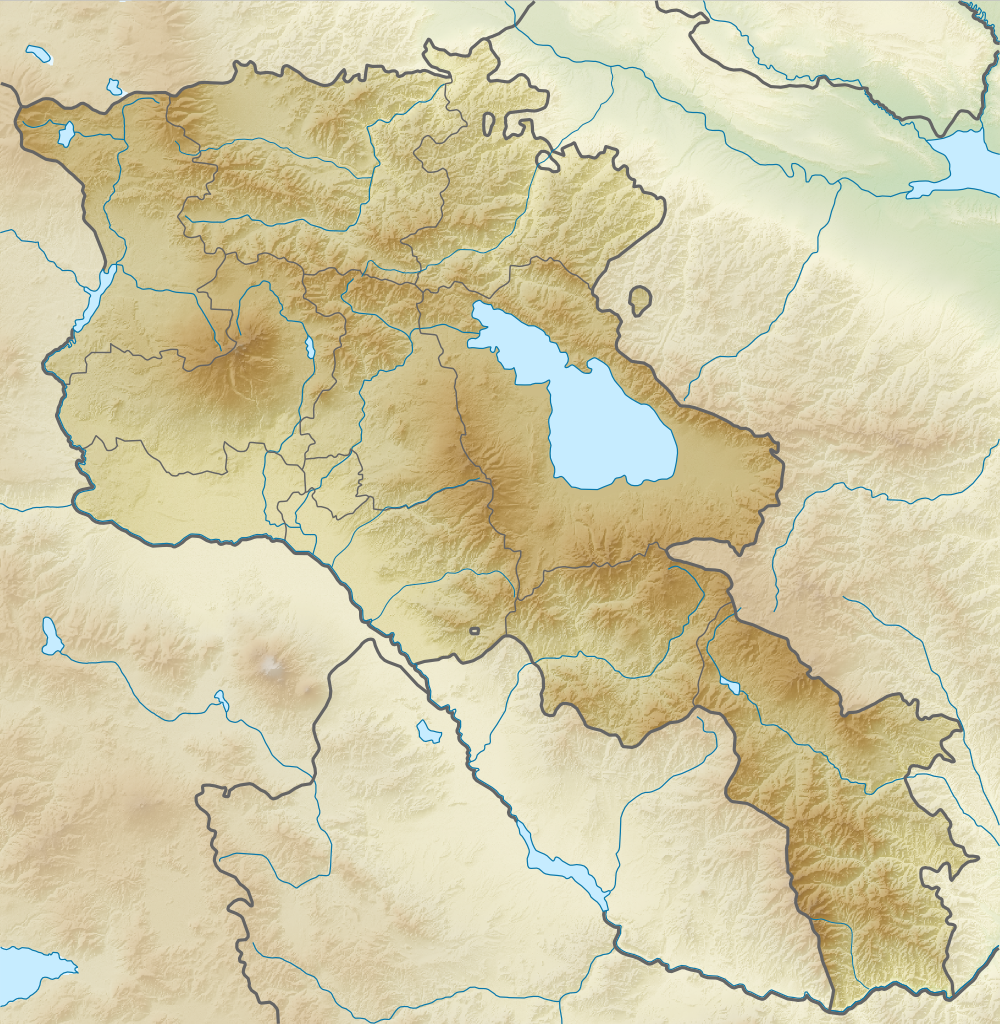
677:}} Equirectangular projection, N/S stretching 130 %. Geographic limits of the map: * N: 41.4° N * S: 38.8° N * W: 43.4° E * E: 46.7° E |Source=*[[:File:Armenia
1056:
268:
666:
1051:
57:
53:
47:
477:
441:
102:
70:
1364:
This file contains additional information, probably added from the digital camera or scanner used to create or digitize it.
338:
956:
991:
846:
425:
497:
461:
408:
655:
650:
625:
620:
595:
590:
255:
1114:
931:
701:
696:
245:
224:
300:
1367:
If the file has been modified from its original state, some details may not fully reflect the modified file.
1204:
986:
881:
691:
1074:
687:
The following pages on the
English Knowledge (XXG) use this file (pages on other projects are not listed):
826:
786:
781:
337:– If you remix, transform, or build upon the material, you must distribute your contributions under the
1094:
821:
771:
751:
297:
1011:
976:
866:
706:
1209:
1089:
1234:
871:
841:
761:
756:
721:
110:
1254:
1134:
996:
856:
736:
716:
1329:
1395:
1021:
861:
726:
1224:
565:
560:
61:
42:
1229:
1026:
1016:
1001:
946:
836:
766:
1219:
583:
No unilateral changes. International borders are used. Please create additional svg map.
1309:
936:
916:
731:
636:
249:
228:
1174:
1244:
941:
154:
Equirectangular projection, N/S stretching 130 %. Geographic limits of the map:
97:
1284:
1179:
1164:
1036:
971:
891:
831:
791:
746:
741:
711:
1239:
1279:
1274:
1129:
1006:
1189:
212:
981:
966:
926:
921:
906:
776:
1159:
1124:
896:
886:
876:
816:
796:
576:
179:
1344:
1149:
148:
1264:
1259:
951:
901:
811:
1324:
1154:
1144:
1031:
851:
806:
801:
674:
1304:
1184:
1289:
1169:
673:== {{int:filedesc}} == {{Information |Description={{en|Relief map of
185:
Projection cylindrique équidistante, avec étirement nord-sud de 130%.
1047:
User:Ty654/List of earthquakes from 1985-1989 exceeding magnitude 6+
1314:
533:
Click on a date/time to view the file as it appeared at that time.
1249:
961:
1319:
1299:
1199:
1194:
1139:
85:
1042:
User:Falcaorib/Mediterranean Basin, Near East and Middle East
1294:
643:
Adding few rivers : Dzoraget, Aghstafa, Azat, Vedi and Megri
384:
Add a one-line explanation of what this file represents
1214:
75:(1,000 × 1,024 pixels, file size: 1.73 MB, MIME type:
912:
List of fossiliferous stratigraphic units in
Armenia
478:
Creative
Commons Attribution-ShareAlike 3.0 Unported
129:
109:
Commons is a freely licensed media file repository.
1269:
1095:Módulu:Mapa de llocalización/datos/Armenia/usu
348:https://creativecommons.org/licenses/by-sa/3.0
90:
354:Creative Commons Attribution-Share Alike 3.0
278:
8:
314:– to copy, distribute and transmit the work
1369:
1090:Módulu:Mapa de llocalización/datos/Armenia
535:
388:
380:
1067:The following other wikis use this file:
1392:
1387:
1379:
1371:
689:
511:
495:
475:
459:
439:
423:
406:
403:
376:
369:
7:
1057:Module:Location map/data/Armenia/doc
301:Attribution-Share Alike 3.0 Unported
524:
289:
284:
1362:
397:
391:
383:
275:
171:
140:
122:
68:
396:
1052:Module:Location map/data/Armenia
392:Carte topographique de l'Arménie
374:
325:Under the following conditions:
296:This file is licensed under the
288:
283:
277:
89:
31:
21:
371:
14:
1135:Şablon:Yer xəritəsi Ermənistan
370:
26:
1:
957:Orgov Radio-Optical Telescope
246:File:Armenia location map.svg
225:File:Armenia location map.svg
36:
1210:Erebuni Dövlət Təbiət Qoruğu
1205:Şikahoğ Dövlət Təbiət Qoruğu
992:St Gregory of Tigran Honents
847:Khosrov Forest State Reserve
404:Items portrayed in this file
1235:Xosrov Dövlət Təbiət Qoruğu
1111:Usage on azb.wikipedia.org
1086:Usage on ast.wikipedia.org
187:Limites de la carte :
1417:
1336:Usage on ba.wikipedia.org
1225:İrəvan Dəmiryol Stansiyası
1121:Usage on az.wikipedia.org
1101:Usage on av.wikipedia.org
1071:Usage on ar.wikipedia.org
339:same or compatible license
1230:Gümrü Dəmiryol Stansiyası
525:
178:Carte topographique de l'
172:
141:
135:Relief Map of Armenia.png
16:
1105:Шаблон:БакІКарта ЦIамухъ
1080:قالب:خريطة مواقع أرمينيا
932:Mordechai Navi Synagogue
702:1988 Armenian earthquake
697:1931 Zangezur earthquake
373:
305:
96:This is a file from the
1330:İrəvan zəlzələsi (1679)
987:Shikahogh State Reserve
882:Lake Arpi National Park
692:1679 Armenia earthquake
672:
642:
612:
591:09:21, 21 February 2014
582:
561:18:21, 22 February 2014
263:
239:
218:
211:
208:
132:
100:. Information from its
1340:Ҡалып:ПозКарта Армения
103:description page there
46:Size of this preview:
1373:Horizontal resolution
1255:Şərqi Göyçə silsiləsi
1160:Qazangöl (Ermənistan)
827:Harichavank Monastery
787:Erebuni State Reserve
782:Dilijan National Park
651:19:36, 26 August 2010
1245:İrəvan Botanika Bağı
822:Haghartsin Monastery
772:Byurakan Observatory
752:Arevik National Park
62:1,000 × 1,024 pixels
1381:Vertical resolution
1220:Göyçə-Zəngi kaskadı
1170:Dilijan Milli Parkı
1012:Tejharuyk Monastery
977:Sevan National Park
867:Lake Akna (Armavir)
707:893 Dvin earthquake
621:19:49, 5 April 2012
320:– to adapt the work
52:Other resolutions:
1285:Bərgüşad silsiləsi
1180:Ardanış yarımadası
872:Lake Akna (Kotayk)
842:Kecharis Monastery
762:Battle of Artaxata
757:Azhdahak (volcano)
722:Akhurian Reservoir
1404:
1403:
1354:more global usage
1315:Axuryan su anbarı
1310:Qanlı göl (Göyçə)
1240:Göyçə Milli Parkı
1063:Global file usage
997:Tanahat Monastery
857:Kirants Monastery
737:Aramazd mountains
717:Akhtala Monastery
680:
462:copyright license
390:
382:
367:
366:
272:
269:Reusing this file
118:
117:
98:Wikimedia Commons
32:Global file usage
1408:
1398:
1396:www.inkscape.org
1370:
1280:Bərgüşad kaskadı
1175:Göyçə yarımadası
1022:Vanadzor (river)
862:Kobayr monastery
727:Akhuryan (river)
663:
633:
603:
573:
426:copyright status
361:
358:
355:
352:
349:
341:as the original.
298:Creative Commons
292:
291:
287:
286:
281:
280:
266:
254:derivative work
214:
177:
146:
136:
130:
114:
93:
92:
86:
80:
78:
65:
58:469 × 480 pixels
54:234 × 240 pixels
48:585 × 599 pixels
1416:
1415:
1411:
1410:
1409:
1407:
1406:
1405:
1394:
1358:
1305:Geğam silsiləsi
1295:Abaran (yaylaq)
1275:Qarnıyarıq dağı
1185:Goravan səhrası
1061:
1027:Vorotan (river)
1017:Tskhouk-Karckar
1002:Tandzut (river)
947:Mount Kaputjugh
837:Javakheti Range
767:Battle of Garni
688:
681:
669:
661:
639:
631:
609:
601:
579:
571:
527:
526:
523:
522:
521:
520:
519:
518:
517:
516:
514:
504:
503:
502:
500:
489:
488:
487:
486:
485:
484:
483:
482:
480:
468:
467:
466:
464:
453:
452:
451:
450:
449:
448:
447:
446:
444:
432:
431:
430:
428:
417:
416:
415:
414:
413:
411:
395:
394:
393:
386:
385:
368:
363:
362:
359:
356:
353:
350:
347:
346:
304:
293:
204:
203:
175:
170:
144:
134:
127:
120:
119:
108:
107:
106:is shown below.
82:
76:
74:
67:
66:
51:
12:
11:
5:
1414:
1412:
1402:
1401:
1400:
1399:
1390:
1386:
1385:
1382:
1378:
1377:
1374:
1361:
1356:of this file.
1350:
1349:
1348:
1347:
1342:
1334:
1333:
1332:
1327:
1322:
1317:
1312:
1307:
1302:
1300:Ajdaak vulkanı
1297:
1292:
1287:
1282:
1277:
1272:
1267:
1262:
1257:
1252:
1247:
1242:
1237:
1232:
1227:
1222:
1217:
1212:
1207:
1202:
1197:
1192:
1190:Tej-əhməd dağı
1187:
1182:
1177:
1172:
1167:
1162:
1157:
1152:
1150:Loru çökəkliyi
1147:
1142:
1137:
1132:
1127:
1119:
1118:
1117:
1109:
1108:
1107:
1099:
1098:
1097:
1092:
1084:
1083:
1082:
1077:
1065:
1064:
1060:
1059:
1054:
1049:
1044:
1039:
1034:
1029:
1024:
1019:
1014:
1009:
1004:
999:
994:
989:
984:
979:
974:
969:
964:
959:
954:
949:
944:
939:
937:Mount Achkasar
934:
929:
924:
919:
917:Masis, Armenia
914:
909:
904:
899:
894:
889:
884:
879:
874:
869:
864:
859:
854:
849:
844:
839:
834:
829:
824:
819:
814:
809:
804:
799:
794:
789:
784:
779:
774:
769:
764:
759:
754:
749:
744:
739:
734:
732:Ara (mountain)
729:
724:
719:
714:
709:
704:
699:
694:
686:
685:
684:
679:
678:
671:
667:
664:
660:1,000 × 1,024
658:
653:
648:
645:
644:
641:
637:
634:
630:1,000 × 1,024
628:
623:
618:
615:
614:
613:Added Artsakh.
611:
607:
604:
598:
593:
588:
585:
584:
581:
577:
574:
570:1,000 × 1,024
568:
563:
558:
554:
553:
550:
547:
544:
541:
538:
531:
530:
515:
513:26 August 2010
512:
510:
509:
508:
507:
506:
505:
501:
496:
494:
493:
492:
491:
490:
481:
476:
474:
473:
472:
471:
470:
469:
465:
460:
458:
457:
456:
455:
454:
445:
440:
438:
437:
436:
435:
434:
433:
429:
424:
422:
421:
420:
419:
418:
412:
407:
405:
402:
401:
400:
399:
398:
387:
379:
378:
375:
372:
365:
364:
345:
344:
343:
342:
332:
323:
322:
321:
315:
308:You are free:
295:
294:
276:
273:
261:
260:
259:
258:
252:
241:
237:
236:
235:
234:
231:
220:
216:
215:
213:26 August 2010
210:
206:
205:
202:
201:
198:
195:
192:
173:
169:
168:
165:
162:
159:
147:Relief map of
142:
139:
137:
128:
126:
123:
121:
116:
115:
94:
84:
83:
45:
41:
40:
39:
34:
29:
24:
19:
13:
10:
9:
6:
4:
3:
2:
1413:
1397:
1393:
1391:
1389:Software used
1388:
1383:
1380:
1375:
1372:
1368:
1365:
1359:
1357:
1355:
1346:
1343:
1341:
1338:
1337:
1335:
1331:
1328:
1326:
1323:
1321:
1318:
1316:
1313:
1311:
1308:
1306:
1303:
1301:
1298:
1296:
1293:
1291:
1288:
1286:
1283:
1281:
1278:
1276:
1273:
1271:
1268:
1266:
1265:Balıqlı (göl)
1263:
1261:
1260:Nərədüz burnu
1258:
1256:
1253:
1251:
1248:
1246:
1243:
1241:
1238:
1236:
1233:
1231:
1228:
1226:
1223:
1221:
1218:
1216:
1213:
1211:
1208:
1206:
1203:
1201:
1198:
1196:
1193:
1191:
1188:
1186:
1183:
1181:
1178:
1176:
1173:
1171:
1168:
1166:
1165:Şəki şəlaləsi
1163:
1161:
1158:
1156:
1153:
1151:
1148:
1146:
1143:
1141:
1138:
1136:
1133:
1131:
1128:
1126:
1123:
1122:
1120:
1116:
1113:
1112:
1110:
1106:
1103:
1102:
1100:
1096:
1093:
1091:
1088:
1087:
1085:
1081:
1078:
1076:
1073:
1072:
1070:
1069:
1068:
1062:
1058:
1055:
1053:
1050:
1048:
1045:
1043:
1040:
1038:
1035:
1033:
1030:
1028:
1025:
1023:
1020:
1018:
1015:
1013:
1010:
1008:
1005:
1003:
1000:
998:
995:
993:
990:
988:
985:
983:
980:
978:
975:
973:
970:
968:
965:
963:
960:
958:
955:
953:
950:
948:
945:
943:
942:Mount Aragats
940:
938:
935:
933:
930:
928:
925:
923:
920:
918:
915:
913:
910:
908:
905:
903:
900:
898:
895:
893:
890:
888:
885:
883:
880:
878:
875:
873:
870:
868:
865:
863:
860:
858:
855:
853:
850:
848:
845:
843:
840:
838:
835:
833:
830:
828:
825:
823:
820:
818:
815:
813:
810:
808:
805:
803:
800:
798:
795:
793:
790:
788:
785:
783:
780:
778:
775:
773:
770:
768:
765:
763:
760:
758:
755:
753:
750:
748:
745:
743:
740:
738:
735:
733:
730:
728:
725:
723:
720:
718:
715:
713:
710:
708:
705:
703:
700:
698:
695:
693:
690:
682:
676:
670:
665:
659:
657:
654:
652:
649:
647:
646:
640:
635:
629:
627:
624:
622:
619:
617:
616:
610:
608:Հայկ Ափրիկյան
605:
599:
597:
594:
592:
589:
587:
586:
580:
575:
569:
567:
564:
562:
559:
556:
555:
551:
548:
545:
542:
539:
537:
536:
534:
528:
499:
479:
463:
443:
427:
410:
351:CC BY-SA 3.0
340:
336:
333:
330:
327:
326:
324:
319:
316:
313:
310:
309:
307:
306:
302:
299:
282:
274:
270:
265:
262:
257:
253:
251:
247:
244:
243:
242:
238:
232:
230:
226:
223:
222:
221:
217:
207:
199:
196:
193:
190:
189:
188:
186:
183:
181:
166:
163:
160:
157:
156:
155:
152:
150:
138:
131:
124:
112:
105:
104:
99:
95:
88:
87:
81:
72:
71:Original file
63:
59:
55:
49:
44:
38:
35:
33:
30:
28:
25:
23:
20:
18:
15:
1366:
1363:
1351:
1325:Gərni dərəsi
1115:قارنی دؤیوشو
1066:
1037:Yerevan Lake
972:Saghmosavank
892:Lake Lessing
832:Hovhannavank
792:Garni Temple
747:Areni Church
742:Areni-1 cave
712:Aghjots Vank
532:
529:File history
334:
328:
317:
311:
250:NordNordWest
229:NordNordWest
184:
153:
111:You can help
101:
69:
22:File history
1250:Ağrı vadisi
1155:Ləlvar dağı
1145:Alagöz dağı
1125:Ağçala dağı
1075:بحيرة سيفان
1007:Teishebaini
442:copyrighted
335:share alike
329:attribution
133:Description
1320:Lecan dağı
1130:Göyçə gölü
982:Sevanavank
967:Proshaberd
927:Meghri Dam
922:Matosavank
907:Lake Sevan
777:Dar-Alages
683:File usage
600:585 × 599
546:Dimensions
264:Permission
167:E: 46.7° E
164:W: 43.4° E
161:S: 38.8° N
158:N: 41.4° N
27:File usage
1384:35.43 dpc
1376:35.43 dpc
1290:Qılıncdağ
1215:Mehri SES
1200:Arpi gölü
1195:Kari gölü
897:Lake Parz
887:Lake Kari
877:Lake Arpi
817:Goshavank
797:Gazanaler
662:(1.73 MB)
632:(1.73 MB)
572:(1.73 MB)
543:Thumbnail
540:Date/Time
498:inception
77:image/png
1360:Metadata
1140:Zəngiçay
952:Noravank
902:Lake Sev
812:Godedzor
668:Виктор В
602:(654 KB)
377:Captions
318:to remix
312:to share
303:license.
256:Виктор_В
200:E: 46,7°
197:S: 38,8°
194:O: 43,4°
191:N: 41,4°
174:Français
37:Metadata
1032:Yerevan
852:Khustup
807:Gladzor
802:Geghard
675:Armenia
557:current
552:Comment
409:depicts
381:English
180:Arménie
149:Armenia
143:English
125:Summary
73:
1270:Apaklu
638:Sémhur
389:French
240:Author
219:Source
1352:View
1345:Севан
962:Porak
233:SRTM3
578:A2D2
549:User
360:true
357:true
209:Date
17:File
227:by
248::
176::
145::
60:|
56:|
50:.
271:)
267:(
182:.
151:.
113:.
79:)
64:.
Text is available under the Creative Commons Attribution-ShareAlike License. Additional terms may apply.