232:
321:
327:
332:
194:
87:
43:
965:
835:
702:
1020:
790:
925:
890:
1070:
940:
373:– You must give appropriate credit, provide a link to the license, and indicate if changes were made. You may do so in any reasonable manner, but not in any way that suggests the licensor endorses you or your use.
930:
815:
855:
830:
1079:
805:
845:
950:
767:
762:
860:
53:
47:
1015:
1010:
98:
66:
820:
305:
173:
935:
613:
577:
1005:
1090:
This file contains additional information, probably added from the digital camera or scanner used to create or digitize it.
800:
380:
561:
533:
518:
505:
633:
597:
478:
461:
1000:
910:
525:
342:
1093:
If the file has been modified from its original state, some details may not fully reflect the modified file.
955:
850:
810:
875:
728:
The following pages on the
English Knowledge (XXG) use this file (pages on other projects are not listed):
945:
379:– If you remix, transform, or build upon the material, you must distribute your contributions under the
747:
339:
701:
696:
57:
42:
870:
795:
757:
752:
742:
975:
106:
200:
970:
1055:
1050:
915:
905:
540:
1121:
266:
This map may be incomplete, and may contain errors. Don't rely solely on it for navigation.
1060:
985:
900:
895:
885:
1030:
313:
93:
414:
231:
712:
995:
920:
880:
840:
785:
261:
161:
737:
217:
204:
1045:
732:
249:
669:
Click on a date/time to view the file as it appeared at that time.
193:
284:
81:
1040:
445:
Add a one-line explanation of what this file represents
423:
If inappropriate please set warp_status = skip to hide.
1051:
Knowledge (XXG):Kartenwerkstatt/Positionskarten/Europa
768:
Module:Location map/data/Russia
Volgograd Oblast/doc
125:
105:
Commons is a freely licensed media file repository.
614:
Creative
Commons Attribution-ShareAlike 2.0 Generic
316:Attribution-ShareAlike 2.0 license (CC-BY-SA 2.0).
312:OpenStreetMap data and maps are licensed under the
71:(865 × 810 pixels, file size: 859 KB, MIME type:
1056:Vorlage:Positionskarte Russland Oblast Wolgograd
763:Module:Location map/data/Russia Volgograd Oblast
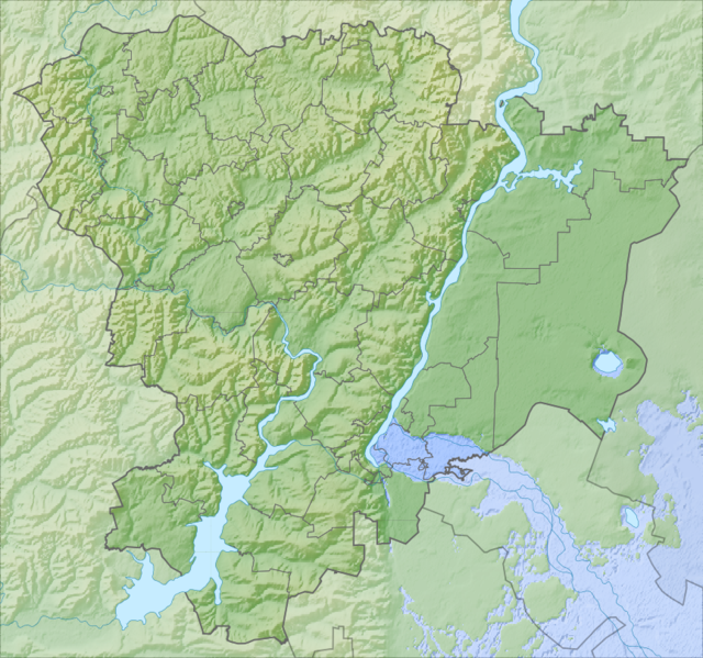
141:Физическая карта Волгоградской области, Россия.
390:https://creativecommons.org/licenses/by-sa/2.0
86:
396:Creative Commons Attribution-Share Alike 2.0
320:
147:Координаты для GMT: -R41.04/47.57/47.36/51.34
8:
1071:Πρότυπο:Location map Περιφέρεια Βολγκογκράντ
966:Кеп:Меттиган карта Росси Волгоградан область
836:Шаблон:На карце/Расія Валгаградская вобласць
356:– to copy, distribute and transmit the work
1095:
671:
541:https://commons.wikimedia.org/user:Nzeemin
441:
264:project data, collected by the community.
778:The following other wikis use this file:
1061:Liste der Städte in der Oblast Wolgograd
1031:Skabelon:Kortpositioner Volgograd oblast
1021:Шаблон:ПозКартти Раççей Волгоград облаçĕ
174:File:Outline Map of Volgograd Oblast.svg
1118:
1113:
1105:
1097:
730:
647:
631:
611:
595:
575:
559:
492:
476:
459:
456:
437:
430:
417:Georeference the map in Wikimaps Warper
227:
791:Ҡалып:ПозКарта Рәсәй Волгоград өлкәһе
7:
926:Краснослободск (Волгоградска област)
178:OpenStreetMap data for region bounds
891:Шаблон:ПК Русия Волгоградска област
660:
343:Attribution-Share Alike 2.0 Generic
331:
326:
1088:
986:Šablona:LocMap Volgogradská oblast
450:
444:
317:
255:Relief Map of Volgograd Oblast.png
198:
135:
131:Relief Map of Volgograd Oblast.png
118:
64:
449:
941:Николаевск (Волгоградска област)
435:
367:Under the following conditions:
338:This file is licensed under the
330:
325:
319:
230:
192:
85:
31:
21:
432:
136:
14:
431:
26:
1:
931:Ленинск (Волгоградска област)
816:Россошка (Карповка ҡушылдығы)
415:
36:
457:Items portrayed in this file
856:Ніжнехапёрскі прыродны парк
260:This map was created from
1143:
1067:Usage on el.wikipedia.org
1037:Usage on de.wikipedia.org
1027:Usage on da.wikipedia.org
992:Usage on cv.wikipedia.org
982:Usage on cs.wikipedia.org
962:Usage on ce.wikipedia.org
951:Бузулук (приток на Хопьор)
867:Usage on bg.wikipedia.org
831:Валгаградскае вадасховішча
827:Usage on be.wikipedia.org
806:Пионерка (Волга ҡушылдығы)
782:Usage on ba.wikipedia.org
381:same or compatible license
295:OpenStreetMap contributors
150:Инструменты: GMT, Inkscape
1046:Wasserkraftwerk Wolgograd
661:
186:
16:
434:
347:
92:This is a file from the
846:Карпаўскае вадасховішча
718:
409:
300:
290:
280:
272:
252:
223:
213:
167:
160:
157:
128:
96:. Information from its
99:description page there
46:Size of this preview:
1099:Horizontal resolution
181:GSHHS data for rivers
1016:Вязовка (Терса юппи)
1011:Бузулук (Хорёр юппи)
748:Tsimlyansk Reservoir
1107:Vertical resolution
758:Volgograd Synagogue
753:Volgograd Reservoir
743:Melovatka Formation
697:19:57, 6 March 2012
362:– to adapt the work
52:Other resolutions:
861:Свірыдаўскія азёры
519:Wikimedia username
506:author name string
276:(see file history)
144:Проекция: Меркатор
1130:
1129:
1080:more global usage
936:Михайловка (град)
821:Дон тәбиғәт паркы
774:Global file usage
721:
598:copyright license
443:
428:
427:
424:
309:
306:Reusing this file
285:openstreetmap.org
267:
241:
240:
203:was created with
114:
113:
94:Wikimedia Commons
32:Global file usage
1134:
1124:
1122:www.inkscape.org
1096:
1041:Oblast Wolgograd
1006:Арчеда (юханшыв)
709:
562:copyright status
543:
538:
528:
523:
513:
510:
422:
421:
419:
418:
403:
400:
397:
394:
391:
383:as the original.
340:Creative Commons
334:
333:
329:
328:
323:
322:
314:Creative Commons
303:
265:
256:
250:
234:
196:
188:
163:
140:
132:
126:
110:
89:
88:
82:
76:
74:
61:
58:865 × 810 pixels
54:256 × 240 pixels
48:640 × 599 pixels
1142:
1141:
1137:
1136:
1135:
1133:
1132:
1131:
1120:
1084:
772:
729:
722:
715:
707:
663:
662:
659:
658:
657:
656:
655:
654:
653:
652:
650:
640:
639:
638:
636:
625:
624:
623:
622:
621:
620:
619:
618:
616:
604:
603:
602:
600:
589:
588:
587:
586:
585:
584:
583:
582:
580:
568:
567:
566:
564:
553:
552:
551:
550:
549:
548:
547:
546:
545:
544:
539:
536:
530:
529:
524:
521:
515:
514:
511:
508:
499:
498:
497:
495:
485:
484:
483:
481:
470:
469:
468:
467:
466:
464:
448:
447:
446:
429:
416:
413:
405:
404:
401:
398:
395:
392:
389:
388:
346:
335:
296:
268:
254:
247:
242:
235:
209:
208:
153:
130:
123:
116:
115:
104:
103:
102:is shown below.
78:
72:
70:
63:
62:
51:
12:
11:
5:
1140:
1138:
1128:
1127:
1126:
1125:
1116:
1112:
1111:
1108:
1104:
1103:
1100:
1087:
1082:of this file.
1076:
1075:
1074:
1073:
1065:
1064:
1063:
1058:
1053:
1048:
1043:
1035:
1034:
1033:
1025:
1024:
1023:
1018:
1013:
1008:
1003:
1001:Булухта (кӳлĕ)
998:
990:
989:
988:
980:
979:
978:
973:
968:
960:
959:
958:
953:
948:
943:
938:
933:
928:
923:
918:
913:
908:
903:
898:
893:
888:
883:
878:
873:
865:
864:
863:
858:
853:
848:
843:
838:
833:
825:
824:
823:
818:
813:
808:
803:
801:Мокрая Мечётка
798:
793:
788:
776:
775:
771:
770:
765:
760:
755:
750:
745:
740:
735:
727:
726:
725:
720:
719:
717:
713:
710:
704:
699:
694:
690:
689:
686:
683:
680:
677:
674:
667:
666:
651:
648:
646:
645:
644:
643:
642:
641:
637:
632:
630:
629:
628:
627:
626:
617:
612:
610:
609:
608:
607:
606:
605:
601:
596:
594:
593:
592:
591:
590:
581:
576:
574:
573:
572:
571:
570:
569:
565:
560:
558:
557:
556:
555:
554:
532:
531:
517:
516:
504:
503:
502:
501:
500:
496:
493:
491:
490:
489:
488:
487:
486:
482:
477:
475:
474:
473:
472:
471:
465:
460:
458:
455:
454:
453:
452:
451:
440:
439:
436:
433:
426:
425:
411:
410:Georeferencing
407:
406:
387:
386:
385:
384:
374:
365:
364:
363:
357:
350:You are free:
337:
336:
318:
310:
298:
297:
294:
292:
288:
287:
282:
278:
277:
274:
270:
269:
259:
257:
248:
246:
243:
239:
238:
237:
236:
229:
225:
224:Other versions
221:
220:
215:
211:
210:
191:
190:
189:
184:
183:
182:
179:
169:
165:
164:
159:
155:
154:
152:
151:
148:
145:
133:
124:
122:
119:
117:
112:
111:
90:
80:
79:
45:
41:
40:
39:
34:
29:
24:
19:
13:
10:
9:
6:
4:
3:
2:
1139:
1123:
1119:
1117:
1115:Software used
1114:
1109:
1106:
1101:
1098:
1094:
1091:
1085:
1083:
1081:
1072:
1069:
1068:
1066:
1062:
1059:
1057:
1054:
1052:
1049:
1047:
1044:
1042:
1039:
1038:
1036:
1032:
1029:
1028:
1026:
1022:
1019:
1017:
1014:
1012:
1009:
1007:
1004:
1002:
999:
997:
994:
993:
991:
987:
984:
983:
981:
977:
976:Кеп:Татол/doc
974:
972:
969:
967:
964:
963:
961:
957:
956:Иловля (река)
954:
952:
949:
947:
944:
942:
939:
937:
934:
932:
929:
927:
924:
922:
919:
917:
914:
912:
909:
907:
904:
902:
899:
897:
894:
892:
889:
887:
884:
882:
879:
877:
874:
872:
869:
868:
866:
862:
859:
857:
854:
852:
851:Ілаўля (рака)
849:
847:
844:
842:
839:
837:
834:
832:
829:
828:
826:
822:
819:
817:
814:
812:
811:Голая (йылға)
809:
807:
804:
802:
799:
797:
794:
792:
789:
787:
784:
783:
781:
780:
779:
773:
769:
766:
764:
761:
759:
756:
754:
751:
749:
746:
744:
741:
739:
736:
734:
731:
723:
716:
711:
705:
703:
700:
698:
695:
692:
691:
687:
684:
681:
678:
675:
673:
672:
670:
664:
635:
615:
599:
579:
563:
542:
535:
527:
520:
507:
480:
463:
420:
412:
408:
393:CC BY-SA 2.0
382:
378:
375:
372:
369:
368:
366:
361:
358:
355:
352:
351:
349:
348:
344:
341:
324:
315:
311:
307:
302:
299:
293:
289:
286:
283:
279:
275:
271:
263:
262:OpenStreetMap
258:
251:
244:
233:
228:
226:
222:
219:
216:
212:
206:
202:
195:
185:
180:
177:
176:
175:
172:
171:
170:
166:
156:
149:
146:
143:
142:
139:
134:
127:
120:
108:
101:
100:
95:
91:
84:
83:
77:
68:
67:Original file
59:
55:
49:
44:
38:
35:
33:
30:
28:
25:
23:
20:
18:
15:
1092:
1089:
1077:
876:Калач на Дон
777:
668:
665:File history
649:6 March 2012
376:
370:
359:
353:
162:6 March 2012
137:
107:You can help
97:
65:
22:File history
911:Котелниково
578:copyrighted
377:share alike
371:attribution
253:Description
129:Description
946:Суровикино
738:Lake Elton
724:File usage
706:865 × 810
682:Dimensions
494:some value
301:Permission
199:This PNG
27:File usage
1110:35.43 dpc
1102:35.43 dpc
971:Кеп:Татол
871:Волгоград
796:Заплавная
679:Thumbnail
676:Date/Time
634:inception
245:Licensing
138:Русский:
73:image/png
1086:Metadata
916:Урюпинск
906:Жирновск
708:(859 KB)
438:Captions
360:to remix
354:to share
345:license.
205:Inkscape
187:Own work
37:Metadata
901:Дубовка
896:Фролово
886:Камишин
714:Nzeemin
693:current
688:Comment
526:Nzeemin
512:Nzeemin
479:creator
462:depicts
442:English
291:Creator
218:Nzeemin
201:graphic
121:Summary
69:
996:Эльтон
921:Котово
881:Волжки
841:Эльтон
786:Торгун
733:Botkul
281:Source
214:Author
197:
168:Source
1078:View
685:User
402:true
399:true
273:Date
158:Date
17:File
534:URL
537::
522::
509::
56:|
50:.
308:)
304:(
207:.
109:.
75:)
60:.
Text is available under the Creative Commons Attribution-ShareAlike License. Additional terms may apply.

