332:
265:
215:
257:
207:
279:
229:
300:
338:
343:
72:
808:"}},"text\/plain":{"en":{"":"heading"}}},"{\"value\":{\"amount\":\"+45\",\"unit\":\"http:\\\/\\\/www.wikidata.org\\\/entity\\\/Q28390\"},\"type\":\"quantity\"}":{"text\/html":{"en":{"P7787":"45
744:"}},"text\/plain":{"en":{"":"heading"}}},"{\"value\":{\"amount\":\"+45\",\"unit\":\"http:\\\/\\\/www.wikidata.org\\\/entity\\\/Q28390\"},\"type\":\"quantity\"}":{"text\/html":{"en":{"P7787":"45
910:
740:
43:
198:
83:
51:
390:– You must give appropriate credit, provide a link to the license, and indicate if changes were made. You may do so in any reasonable manner, but not in any way that suggests the licensor endorses you or your use.
805:
741:
909:
904:
42:
176:
927:== {{int:filedesc}} == {{Information |Description={{en|1=Remains of St Margaret's, West Raynham}} |Source=From ; transferd by
642:
606:
570:
272:
222:
677:
1102:
307:
976:
This file contains additional information, probably added from the digital camera or scanner used to create or digitize it.
397:
920:
533:
846:
819:
782:
755:
685:
626:
554:
526:
513:
498:
713:
670:
655:
590:
471:
454:
294:
353:
979:
If the file has been modified from its original state, some details may not fully reflect the modified file.
988:
1129:
396:– If you remix, transform, or build upon the material, you must distribute your contributions under the
314:
on the
Geograph website for the photographer's contact details. The copyright on this image is owned by
350:
1165:
812:"}},"text\/plain":{"en":{"P7787":"45 degree"}}}}": -->
748:"}},"text\/plain":{"en":{"P7787":"45 degree"}}}}": -->
91:
1227:
505:
692:
662:
1071:
928:
278:
228:
1201:
1147:
1005:
319:
78:
1237:
1034:
945:
150:
1175:
212:
135:
262:
165:
146:
1247:
1015:
299:
52:
Remains_of_St_Margaret's,_West_Raynham_-_geograph.org.uk_-_401694.jpg
998:
311:
116:
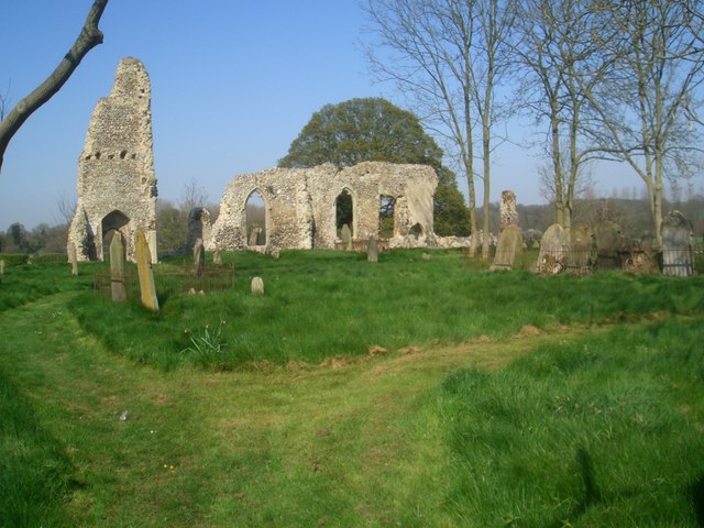
Remains of St
Margaret's, West Raynham - geograph.org.uk - 401694.jpg
877:
Click on a date/time to view the file as it appeared at that time.
264:
214:
199:
52° 47′ 36.54″ N, 0° 46′ 33.11″ E
154:
239:
189:
66:
963:
249:
52° 47′ 38″ N, 0° 46′ 36″ E
438:
Add a one-line explanation of what this file represents
183:
Creative
Commons Attribution Share-alike license 2.0
110:
90:
Commons is a freely licensed media file repository.
607:
Creative
Commons Attribution-ShareAlike 2.0 Generic
56:(640 × 480 pixels, file size: 118 KB, MIME type:
931:using [http://toolserver.org/~magnus/geograph_o
407:https://creativecommons.org/licenses/by-sa/2.0
71:
413:Creative Commons Attribution-Share Alike 2.0
331:
8:
809:
745:
373:– to copy, distribute and transmit the work
981:
879:
434:
956:The following other wikis use this file:
506:https://www.geograph.org.uk/profile/12554
663:https://www.geograph.org.uk/photo/401694
1245:
1235:
1225:
1217:
1209:
1199:
1191:
1183:
1173:
1163:
1155:
1145:
1137:
1127:
1119:
1111:
1100:
1092:
1084:
1076:
1066:
1058:
1050:
1042:
1031:
1023:
1013:
1003:
993:
943:
833:
817:
769:
753:
727:
711:
640:
624:
604:
588:
568:
552:
485:
469:
452:
449:
430:
423:
242:
192:
271:View this and other nearby images on:
221:View this and other nearby images on:
126:Remains of St Margaret's, West Raynham
983:
7:
1170:Flash fired, compulsory flash firing
318:and is licensed for reuse under the
941:The following page uses this file:
868:
354:Attribution-Share Alike 2.0 Generic
342:
337:
322:Attribution-ShareAlike 2.0 license.
974:
443:
437:
328:
305:
120:
103:
49:
442:
1025:Date and time of data generation
756:coordinates of the point of view
428:
384:Under the following conditions:
349:This file is licensed under the
341:
336:
330:
298:
277:
263:
255:
227:
213:
205:
70:
31:
21:
922:File Upload Bot (Magnus Manske)
425:
121:
46:No higher resolution available.
14:
643:file available on the internet
424:
306:This image was taken from the
26:
1:
820:coordinates of depicted place
771:52°47'36.539"N, 0°46'33.110"E
36:
678:Geograph Britain and Ireland
527:object of statement has role
450:Items portrayed in this file
1113:Date and time of digitizing
835:52°47'38.26"N, 0°46'36.12"E
254:
204:
1269:
1211:Focal length in 35 mm film
960:Usage on pl.wikipedia.org
398:same or compatible license
1078:File change date and time
869:
16:
686:geograph.org.uk image ID
427:
364:
77:This is a file from the
1185:Custom image processing
989:CASIO COMPUTER CO.,LTD
926:
171:
161:
141:
134:
131:
113:
81:. Information from its
1121:Image compression mode
905:10:32, 31 January 2010
312:this photograph's page
283:52.793960; 0.776700
233:52.793483; 0.775864
84:description page there
1139:Maximum land aperture
1072:1.00
1052:Horizontal resolution
1116:21:57, 19 April 2004
1081:21:57, 19 April 2004
1028:21:57, 19 April 2004
155:geograph_org2commons
1086:Y and C positioning
1060:Vertical resolution
985:Camera manufacturer
379:– to adapt the work
1219:Scene capture type
1206:Auto white balance
514:author name string
1256:
1255:
1010:1/500 sec (0.002)
952:Global file usage
934:
811:
747:
591:copyright license
436:
327:
326:
310:collection. See
288:
287:
238:
237:
187:
186:
180:
177:Reusing this file
149:; transferred by
99:
98:
79:Wikimedia Commons
32:Global file usage
1260:
1094:Exposure Program
982:
917:
857:
856:
851:
793:
792:
787:
695:
690:
680:
675:
665:
660:
656:described at URL
555:copyright status
536:
531:
521:
518:
508:
503:
420:
417:
414:
411:
408:
400:as the original.
362:
351:Creative Commons
345:
344:
340:
339:
334:
333:
320:Creative Commons
308:Geograph project
302:
295:
284:
281:
267:
266:
260:
259:
258:
252:
251:
240:
234:
231:
217:
216:
210:
209:
208:
202:
201:
190:
174:
137:
125:
117:
111:
95:
74:
73:
67:
61:
59:
1268:
1267:
1263:
1262:
1261:
1259:
1258:
1257:
1124:4.5333333333333
970:
950:
935:
929:User:Multichill
923:
915:
871:
870:
867:
866:
865:
864:
863:
862:
861:
860:
859:
858:
854:
852:
849:
840:
839:
838:
836:
826:
825:
824:
822:
803:
802:
801:
800:
799:
798:
797:
796:
795:
794:
790:
788:
785:
776:
775:
774:
772:
762:
761:
760:
758:
739:
738:
737:
736:
735:
734:
733:
732:
730:
720:
719:
718:
716:
705:
704:
703:
702:
701:
700:
699:
698:
697:
696:
691:
688:
682:
681:
676:
673:
667:
666:
661:
658:
649:
648:
647:
645:
633:
632:
631:
629:
618:
617:
616:
615:
614:
613:
612:
611:
609:
597:
596:
595:
593:
582:
581:
580:
579:
578:
577:
576:
575:
573:
561:
560:
559:
557:
546:
545:
544:
543:
542:
541:
540:
539:
538:
537:
532:
529:
523:
522:
519:
516:
510:
509:
504:
501:
492:
491:
490:
488:
478:
477:
476:
474:
463:
462:
461:
460:
459:
457:
441:
440:
439:
422:
421:
418:
415:
412:
409:
406:
405:
363:
360:
357:
346:
323:
293:
282:
256:
247:
246:
243:Object location
232:
206:
197:
196:
193:Camera location
188:
151:User:Multichill
147:geograph.org.uk
127:
115:
108:
101:
100:
89:
88:
87:is shown below.
63:
57:
55:
48:
47:
12:
11:
5:
1266:
1264:
1254:
1253:
1250:
1244:
1243:
1240:
1234:
1233:
1230:
1224:
1223:
1220:
1216:
1215:
1212:
1208:
1207:
1204:
1198:
1197:
1194:
1190:
1189:
1188:Normal process
1186:
1182:
1181:
1178:
1172:
1171:
1168:
1162:
1161:
1158:
1154:
1153:
1150:
1144:
1143:
1140:
1136:
1135:
1132:
1126:
1125:
1122:
1118:
1117:
1114:
1110:
1109:
1106:
1099:
1098:
1097:Normal program
1095:
1091:
1090:
1087:
1083:
1082:
1079:
1075:
1074:
1069:
1065:
1064:
1061:
1057:
1056:
1053:
1049:
1048:
1045:
1041:
1040:
1037:
1030:
1029:
1026:
1022:
1021:
1018:
1012:
1011:
1008:
1002:
1001:
996:
992:
991:
986:
973:
969:
968:
967:
966:
954:
953:
949:
948:
939:
938:
933:
932:
925:
921:
918:
912:
907:
902:
898:
897:
894:
891:
888:
885:
882:
875:
874:
845:
844:
843:
842:
841:
837:
834:
832:
831:
830:
829:
828:
827:
823:
818:
816:
815:
814:
813:
807:
781:
780:
779:
778:
777:
773:
770:
768:
767:
766:
765:
764:
763:
759:
754:
752:
751:
750:
749:
743:
731:
728:
726:
725:
724:
723:
722:
721:
717:
712:
710:
709:
708:
707:
706:
684:
683:
669:
668:
654:
653:
652:
651:
650:
646:
641:
639:
638:
637:
636:
635:
634:
630:
627:source of file
625:
623:
622:
621:
620:
619:
610:
605:
603:
602:
601:
600:
599:
598:
594:
589:
587:
586:
585:
584:
583:
574:
569:
567:
566:
565:
564:
563:
562:
558:
553:
551:
550:
549:
548:
547:
525:
524:
512:
511:
497:
496:
495:
494:
493:
489:
486:
484:
483:
482:
481:
480:
479:
475:
470:
468:
467:
466:
465:
464:
458:
453:
451:
448:
447:
446:
445:
444:
433:
432:
429:
426:
404:
403:
402:
401:
391:
382:
381:
380:
374:
367:You are free:
358:
348:
347:
329:
325:
324:
303:
292:
289:
286:
285:
275:
269:
244:
236:
235:
225:
219:
194:
185:
184:
181:
169:
168:
163:
159:
158:
143:
139:
138:
133:
129:
128:
118:
109:
107:
104:
102:
97:
96:
75:
65:
64:
45:
41:
40:
39:
34:
29:
24:
19:
13:
10:
9:
6:
4:
3:
2:
1265:
1251:
1249:
1246:
1241:
1239:
1236:
1231:
1229:
1226:
1221:
1218:
1213:
1210:
1205:
1203:
1202:White balance
1200:
1196:Auto exposure
1195:
1193:Exposure mode
1192:
1187:
1184:
1179:
1177:
1174:
1169:
1167:
1164:
1159:
1156:
1151:
1149:
1148:Metering mode
1146:
1141:
1138:
1133:
1131:
1130:Exposure bias
1128:
1123:
1120:
1115:
1112:
1107:
1104:
1101:
1096:
1093:
1088:
1085:
1080:
1077:
1073:
1070:
1068:Software used
1067:
1062:
1059:
1054:
1051:
1046:
1043:
1038:
1036:
1032:
1027:
1024:
1019:
1017:
1014:
1009:
1007:
1006:Exposure time
1004:
1000:
997:
994:
990:
987:
984:
980:
977:
971:
965:
962:
961:
959:
958:
957:
951:
947:
944:
942:
936:
930:
924:
919:
913:
911:
908:
906:
903:
900:
899:
895:
892:
889:
886:
883:
881:
880:
878:
872:
848:
821:
784:
757:
729:15 April 2007
715:
694:
687:
679:
672:
664:
657:
644:
628:
608:
592:
572:
556:
535:
528:
515:
507:
500:
473:
456:
410:CC BY-SA 2.0
399:
395:
392:
389:
386:
385:
383:
378:
375:
372:
369:
368:
366:
365:
359:Attribution:
355:
352:
335:
321:
317:
313:
309:
304:
301:
297:
296:
290:
280:
276:
274:
273:OpenStreetMap
270:
268:
250:
245:
241:
230:
226:
224:
223:OpenStreetMap
220:
218:
200:
195:
191:
182:
178:
173:
170:
167:
164:
160:
156:
152:
148:
144:
140:
136:15 April 2007
130:
124:
119:
112:
105:
93:
86:
85:
80:
76:
69:
68:
62:
53:
44:
38:
35:
33:
30:
28:
25:
23:
20:
18:
15:
1157:Light source
1142:4 APEX (f/4)
1035:focal length
995:Camera model
978:
975:
964:West Raynham
955:
946:West Raynham
940:
876:
873:File history
534:photographer
393:
387:
376:
370:
315:
253:
203:
122:
92:You can help
82:
50:
22:File history
1176:Color space
1044:Orientation
571:copyrighted
520:Nigel Jones
394:share alike
388:attribution
361:Nigel Jones
316:Nigel Jones
166:Nigel Jones
114:Description
1238:Saturation
937:File usage
914:640 × 480
890:Dimensions
487:some value
172:Permission
58:image/jpeg
27:File usage
1248:Sharpness
887:Thumbnail
884:Date/Time
714:inception
291:Licensing
123:English:
1228:Contrast
1222:Standard
1089:Centered
1016:F-number
972:Metadata
916:(118 KB)
671:operator
431:Captions
377:to remix
371:to share
356:license.
37:Metadata
1160:Unknown
1152:Pattern
1105:version
999:EX-S100
901:current
896:Comment
847:heading
806:heading
783:heading
742:heading
472:creator
455:depicts
435:English
106:Summary
54:
1252:Normal
1242:Normal
1232:Normal
1063:72 dpi
1055:72 dpi
1047:Normal
1039:4.8 mm
855:degree
810:degree
791:degree
746:degree
693:401694
261:
211:
162:Author
153:using
142:Source
1214:36 mm
1166:Flash
1033:Lens
145:From
1180:sRGB
1108:2.21
1103:Exif
893:User
419:true
416:true
132:Date
17:File
1020:f/4
853:45
789:45
499:URL
850::
786::
689::
674::
659::
530::
517::
502::
1134:0
179:)
175:(
157:.
94:.
60:)
Text is available under the Creative Commons Attribution-ShareAlike License. Additional terms may apply.
_region:GB-GBN_heading:45.00&language=en)
