433:
386:
439:
43:
99:
444:
219:
853:
823:
793:
492:– You must give appropriate credit, provide a link to the license, and indicate if changes were made. You may do so in any reasonable manner, but not in any way that suggests the licensor endorses you or your use.
1282:
1007:
870:== Description, Source == * Description: Topography of Rhodos, created with 4.1.3 * Source: At least one of the following Public Domain data sources ** (Resolution 2
1182:
403:
1307:
1287:
1356:
401:; with no Invariant Sections, no Front-Cover Texts, and no Back-Cover Texts. A copy of the license is included in the section entitled
205:
393:
894:
704:
687:
651:
1367:
This file contains additional information, probably added from the digital camera or scanner used to create or digitize it.
499:
635:
398:
724:
671:
618:
1232:
453:
65:
61:
57:
53:
47:
1370:
If the file has been modified from its original state, some details may not fully reflect the modified file.
982:
884:
227:
110:
880:
The following pages on the
English Knowledge (XXG) use this file (pages on other projects are not listed):
852:
847:
822:
817:
78:
498:– If you remix, transform, or build upon the material, you must distribute your contributions under the
370:
450:
1327:
863:
833:
803:
118:
380:
212:
513:
391:
Permission is granted to copy, distribute and/or modify this document under the terms of the
992:
194:
235:
105:
250:
169:
1172:
1127:
942:
792:
787:
266:
260:
256:
246:
242:
175:
69:
42:
154:
1237:
1082:
1347:
1277:
1222:
1002:
932:
360:
351:
181:
1062:
1052:
231:
1162:
1057:
1047:
342:
1022:
554:
333:
324:
315:
306:
297:
288:
279:
922:
889:
760:
Click on a date/time to view the file as it appeared at that time.
1157:
1233:
Gebruiker:Leonidas1206/Kladblok/Beleg van Rhodos (305-304 v.Chr.)
270:
1137:
143:
542:
512:
This licensing tag was added to this file as part of the GFDL
427:
218:
93:
1112:
1297:
1267:
1032:
165:
At least one of the following Public Domain data sources
1247:
1147:
1117:
1102:
1042:
952:
602:
Add a one-line explanation of what this file represents
361:
352:
840:
added cities, mountains; used etopo1 instead of etopo2
1192:
705:
688:
Creative
Commons Attribution-ShareAlike 3.0 Unported
397:, Version 1.2 or any later version published by the
132:
117:
Commons is a freely licensed media file repository.
1317:
1257:
1202:
972:
912:
343:
83:(1,500 × 1,496 pixels, file size: 1 MB, MIME type:
1337:
1212:
1092:
1072:
1017:
962:
334:
325:
316:
307:
298:
289:
280:
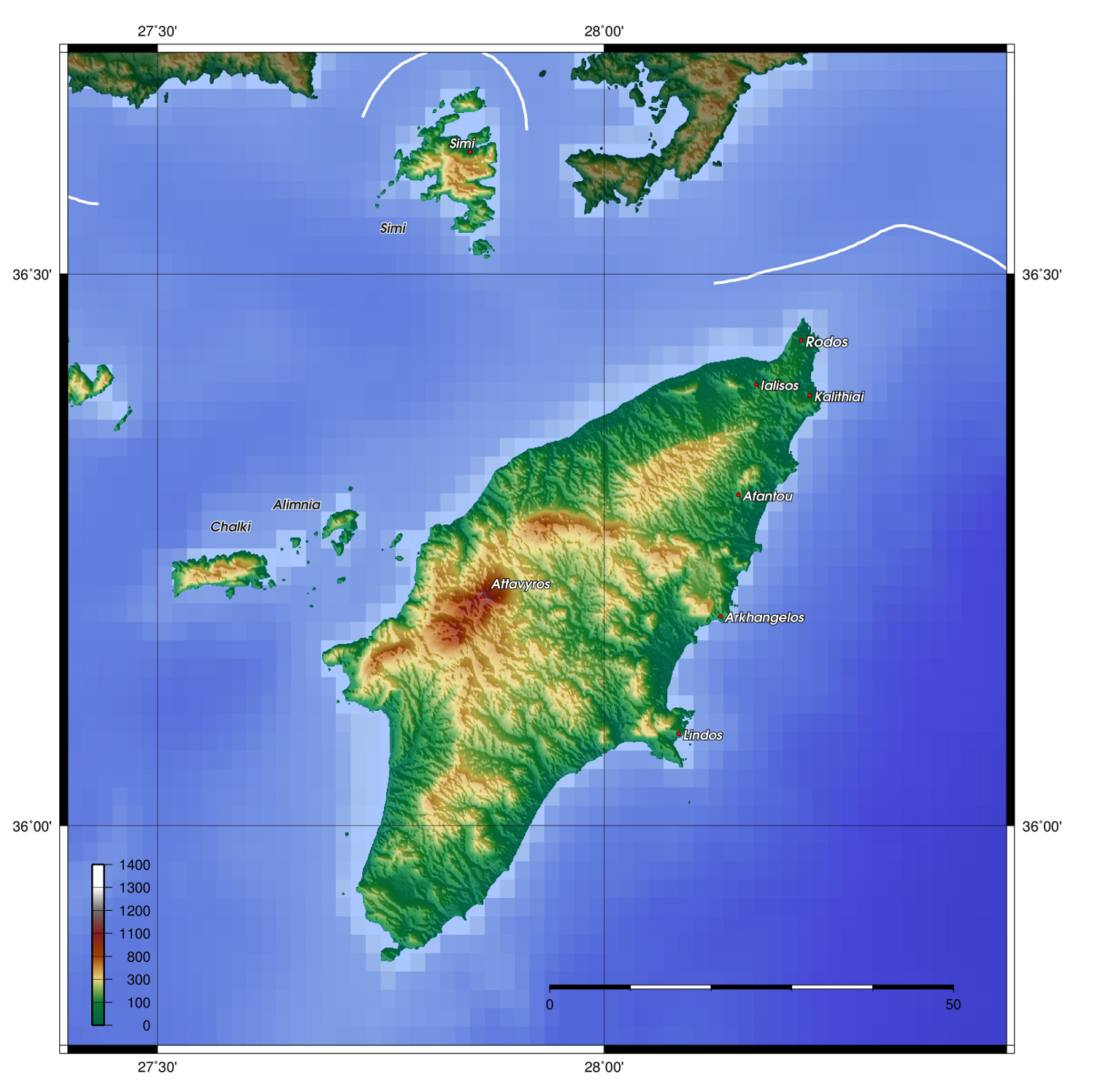
142:Description: Topography of Rhodes, created with
251:http://www.ngdc.noaa.gov/mgg/global/global.html
519:http://creativecommons.org/licenses/by-sa/3.0/
261:http://www.ngdc.noaa.gov/mgg/topo/gltiles.html
98:
432:
8:
525:Creative Commons Attribution-Share Alike 3.0
475:– to copy, distribute and transmit the work
1372:
762:
598:
369:
905:The following other wikis use this file:
1390:
1382:
1374:
993:Belagerung von Rhodos (305–304 v. Chr.)
882:
738:
722:
702:
685:
669:
649:
633:
616:
613:
594:
587:
232:https://www.generic-mapping-tools.org/
7:
1283:Осада Родоса (305—304 годы до н. э.)
454:Attribution-Share Alike 3.0 Unported
409:http://www.gnu.org/copyleft/fdl.html
751:
443:
438:
1365:
1008:Πολιορκία της Ρόδου (305-304 π.Χ.)
607:
601:
226:The map has been created with the
130:
76:
1238:Beleg van Rhodos (305-304 v.Chr.)
1134:Usage on incubator.wikimedia.org
606:
592:
486:Under the following conditions:
449:This file is licensed under the
442:
437:
431:
385:
384:
217:
97:
31:
21:
589:
555:View the annotations at Commons
14:
588:
415:GNU Free Documentation License
404:GNU Free Documentation License
394:GNU Free Documentation License
271:http://www2.jpl.nasa.gov/srtm/
26:
1:
1308:Опсада Родоса (305. п. н. е.)
1063:Malline:Valitut palat/2016/49
1053:Malline:Valitut palat/2013/18
36:
895:Siege of Rhodes (305–304 BC)
614:Items portrayed in this file
1189:Usage on la.wiktionary.org
234:using one or more of these
1412:
1344:Usage on tt.wikipedia.org
1334:Usage on tr.wikipedia.org
1324:Usage on ta.wikipedia.org
1314:Usage on sv.wikipedia.org
1304:Usage on sr.wikipedia.org
1294:Usage on sk.wikipedia.org
1288:Осада Родоса (88 до н. э.)
1274:Usage on ru.wikipedia.org
1264:Usage on pl.wikipedia.org
1254:Usage on no.wikipedia.org
1244:Usage on nn.wikipedia.org
1229:Usage on nl.wikipedia.org
1219:Usage on mk.wikipedia.org
1209:Usage on lt.wikipedia.org
1199:Usage on lb.wikipedia.org
1179:Usage on ka.wikipedia.org
1169:Usage on ja.wikipedia.org
1163:Assedio di Rodi (305 a.C.)
1154:Usage on it.wikipedia.org
1144:Usage on is.wikipedia.org
1124:Usage on hy.wikipedia.org
1109:Usage on hu.wikipedia.org
1099:Usage on hr.wikipedia.org
1089:Usage on gl.wikipedia.org
1079:Usage on fr.wikipedia.org
1069:Usage on fo.wikipedia.org
1058:Malline:Valitut palat/2016
1048:Malline:Valitut palat/2013
1039:Usage on fi.wikipedia.org
1029:Usage on et.wikipedia.org
1014:Usage on es.wikipedia.org
999:Usage on el.wikipedia.org
989:Usage on de.wikipedia.org
979:Usage on cv.wikipedia.org
969:Usage on cs.wikipedia.org
959:Usage on ca.wikipedia.org
949:Usage on br.wikipedia.org
939:Usage on bn.wikipedia.org
929:Usage on bg.wikipedia.org
919:Usage on ar.wikipedia.org
909:Usage on af.wikipedia.org
500:same or compatible license
1392:File change date and time
1023:Sitio de Rodas (305 a.C.)
752:
552:This image is annotated:
458:
430:
238:datasets for the relief:
16:
591:
399:Free Software Foundation
178:(Resolution 30' = 0,9km)
104:This is a file from the
1395:11:01, 20 November 2012
1083:Profítis Ilías (Rhodes)
885:Profitis Ilias (Rhodes)
869:
839:
809:
788:13:23, 20 November 2012
200:
190:
172:(Resolution 1° = 1,8km)
160:
153:
150:
135:
108:. Information from its
111:description page there
46:Size of this preview:
1376:Horizontal resolution
1158:Utente:Pigr8/Sandbox2
228:Generic Mapping Tools
184:(Resolution 3' = 90m)
70:1,500 × 1,496 pixels
66:1,027 × 1,024 pixels
1384:Vertical resolution
848:12:06, 12 July 2006
481:– to adapt the work
52:Other resolutions:
1399:
1398:
1357:more global usage
901:Global file usage
873:
818:07:29, 8 May 2009
672:copyright license
600:
561:
560:
540:
539:
536:
535:
426:
425:
379:
378:
373:
209:
206:Reusing this file
126:
125:
106:Wikimedia Commons
32:Global file usage
1403:
1373:
860:
830:
800:
636:copyright status
543:
532:
529:
526:
523:
520:
517:
514:licensing update
502:as the original.
451:Creative Commons
446:
445:
441:
440:
435:
434:
428:
422:
419:
416:
413:
410:
388:
387:
381:
374:
221:
213:
203:
156:
139:
133:
122:
101:
100:
94:
88:
86:
73:
62:770 × 768 pixels
58:481 × 480 pixels
54:241 × 240 pixels
48:601 × 599 pixels
1411:
1410:
1406:
1405:
1404:
1402:
1401:
1400:
1361:
1113:Rodosz (sziget)
899:
881:
874:
866:
858:
836:
828:
806:
798:
754:
753:
750:
749:
748:
747:
746:
745:
744:
743:
741:
731:
730:
729:
727:
716:
715:
714:
713:
712:
711:
710:
709:
707:
696:
695:
694:
693:
692:
690:
678:
677:
676:
674:
663:
662:
661:
660:
659:
658:
657:
656:
654:
642:
641:
640:
638:
627:
626:
625:
624:
623:
621:
605:
604:
603:
586:
585:
580:
577:
574:
571:
568:
565:
549:
541:
530:
527:
524:
521:
518:
511:
420:
417:
414:
411:
408:
363:
354:
345:
336:
327:
318:
309:
300:
291:
282:
278:
275:
222:
138:Rhodos topo.png
137:
128:
127:
116:
115:
114:is shown below.
90:
84:
82:
75:
74:
51:
12:
11:
5:
1409:
1407:
1397:
1396:
1393:
1389:
1388:
1385:
1381:
1380:
1377:
1364:
1359:of this file.
1353:
1352:
1351:
1350:
1342:
1341:
1340:
1332:
1331:
1330:
1322:
1321:
1320:
1312:
1311:
1310:
1302:
1301:
1300:
1298:Rodos (ostrov)
1292:
1291:
1290:
1285:
1280:
1272:
1271:
1270:
1262:
1261:
1260:
1252:
1251:
1250:
1242:
1241:
1240:
1235:
1227:
1226:
1225:
1217:
1216:
1215:
1207:
1206:
1205:
1197:
1196:
1195:
1187:
1186:
1185:
1183:ხმელთაშუა ზღვა
1177:
1176:
1175:
1167:
1166:
1165:
1160:
1152:
1151:
1150:
1142:
1141:
1140:
1132:
1131:
1130:
1122:
1121:
1120:
1115:
1107:
1106:
1105:
1097:
1096:
1095:
1087:
1086:
1085:
1077:
1076:
1075:
1067:
1066:
1065:
1060:
1055:
1050:
1045:
1037:
1036:
1035:
1027:
1026:
1025:
1020:
1012:
1011:
1010:
1005:
997:
996:
995:
987:
986:
985:
977:
976:
975:
967:
966:
965:
957:
956:
955:
947:
946:
945:
937:
936:
935:
927:
926:
925:
917:
916:
915:
903:
902:
898:
897:
892:
887:
879:
878:
877:
872:
871:
868:
864:
861:
855:
850:
845:
842:
841:
838:
834:
831:
827:1,500 × 1,394
825:
820:
815:
812:
811:
808:
804:
801:
797:1,500 × 1,496
795:
790:
785:
781:
780:
777:
774:
771:
768:
765:
758:
757:
742:
739:
737:
736:
735:
734:
733:
732:
728:
723:
721:
720:
719:
718:
717:
708:
703:
701:
700:
699:
698:
697:
691:
686:
684:
683:
682:
681:
680:
679:
675:
670:
668:
667:
666:
665:
664:
655:
650:
648:
647:
646:
645:
644:
643:
639:
634:
632:
631:
630:
629:
628:
622:
617:
615:
612:
611:
610:
609:
608:
597:
596:
593:
590:
581:
578:
575:
572:
569:
566:
563:
562:
559:
558:
550:
547:
538:
537:
534:
533:
508:
507:
506:
505:
504:
503:
493:
484:
483:
482:
476:
469:You are free:
464:
463:
460:
459:
457:
447:
424:
423:
389:
377:
376:
274:
273:
263:
253:
225:
223:
216:
210:
198:
197:
192:
188:
187:
186:
185:
179:
173:
162:
158:
157:
152:
148:
147:
140:
131:
129:
124:
123:
102:
92:
91:
45:
41:
40:
39:
34:
29:
24:
19:
13:
10:
9:
6:
4:
3:
2:
1408:
1394:
1391:
1386:
1383:
1378:
1375:
1371:
1368:
1362:
1360:
1358:
1349:
1346:
1345:
1343:
1339:
1336:
1335:
1333:
1329:
1326:
1325:
1323:
1319:
1316:
1315:
1313:
1309:
1306:
1305:
1303:
1299:
1296:
1295:
1293:
1289:
1286:
1284:
1281:
1279:
1276:
1275:
1273:
1269:
1268:Rodos (wyspa)
1266:
1265:
1263:
1259:
1256:
1255:
1253:
1249:
1246:
1245:
1243:
1239:
1236:
1234:
1231:
1230:
1228:
1224:
1221:
1220:
1218:
1214:
1211:
1210:
1208:
1204:
1201:
1200:
1198:
1194:
1191:
1190:
1188:
1184:
1181:
1180:
1178:
1174:
1171:
1170:
1168:
1164:
1161:
1159:
1156:
1155:
1153:
1149:
1146:
1145:
1143:
1139:
1136:
1135:
1133:
1129:
1126:
1125:
1123:
1119:
1116:
1114:
1111:
1110:
1108:
1104:
1101:
1100:
1098:
1094:
1091:
1090:
1088:
1084:
1081:
1080:
1078:
1074:
1071:
1070:
1068:
1064:
1061:
1059:
1056:
1054:
1051:
1049:
1046:
1044:
1041:
1040:
1038:
1034:
1031:
1030:
1028:
1024:
1021:
1019:
1016:
1015:
1013:
1009:
1006:
1004:
1001:
1000:
998:
994:
991:
990:
988:
984:
983:Родос (утрав)
981:
980:
978:
974:
971:
970:
968:
964:
961:
960:
958:
954:
951:
950:
948:
944:
941:
940:
938:
934:
931:
930:
928:
924:
921:
920:
918:
914:
911:
910:
908:
907:
906:
900:
896:
893:
891:
888:
886:
883:
875:
867:
862:
856:
854:
851:
849:
846:
844:
843:
837:
832:
826:
824:
821:
819:
816:
814:
813:
807:
802:
796:
794:
791:
789:
786:
783:
782:
778:
775:
772:
769:
766:
764:
763:
761:
755:
726:
706:
689:
673:
653:
637:
620:
584:
557:
556:
551:
545:
544:
515:
510:
509:
501:
497:
494:
491:
488:
487:
485:
480:
477:
474:
471:
470:
468:
467:
466:
465:
462:
461:
455:
452:
448:
436:
429:
406:
405:
400:
396:
395:
390:
383:
382:
375:
372:
368:
364:
359:
355:
350:
346:
341:
337:
332:
328:
323:
319:
314:
310:
305:
301:
296:
292:
287:
283:
276:
272:
268:
264:
262:
258:
254:
252:
248:
244:
240:
239:
237:
236:public-domain
233:
229:
224:
220:
215:
214:
211:
207:
202:
199:
196:
193:
189:
183:
180:
177:
174:
171:
168:
167:
166:
163:
159:
149:
145:
141:
134:
120:
113:
112:
107:
103:
96:
95:
89:
80:
79:Original file
71:
67:
63:
59:
55:
49:
44:
38:
35:
33:
30:
28:
25:
23:
20:
18:
15:
1369:
1366:
1354:
1138:Wy/diq/Rodos
1033:Rhodose saar
904:
759:
756:File history
740:22 June 2006
582:
553:
522:CC BY-SA 3.0
495:
489:
478:
472:
402:
392:
366:
357:
348:
339:
330:
321:
312:
303:
294:
285:
277:
164:
155:22 June 2006
119:You can help
109:
77:
22:File history
652:copyrighted
546:Annotations
496:share alike
490:attribution
136:Description
1387:118.11 dpc
1379:118.11 dpc
1103:Rod (otok)
953:Enez Rodos
876:File usage
857:969 × 975
810:new labels
773:Dimensions
335:македонски
267:topography
257:topography
247:bathymetry
243:topography
201:Permission
27:File usage
829:(1.03 MB)
770:Thumbnail
767:Date/Time
725:inception
548:InfoField
456:license.
344:sicilianu
85:image/png
1363:Metadata
859:(838 KB)
595:Captions
479:to remix
473:to share
317:italiano
308:français
241:ETOPO2 (
37:Metadata
865:Zamonin
835:Zamonin
805:Zamonin
784:current
779:Comment
619:depicts
599:English
299:español
290:English
255:GLOBE (
195:Zamonin
81:
1328:ரோட்ஸ்
1318:Rhodos
1258:Rhodos
1203:Rhodos
1193:Rhodus
1128:Հռոդոս
973:Rhodos
913:Rhodos
890:Rhodes
799:(1 MB)
583:Ρόδος
365:
362:中文(繁體)
356:
353:中文(简体)
347:
338:
329:
320:
311:
302:
293:
284:
265:SRTM (
191:Author
170:ETOPO1
161:Source
1355:View
1348:Родос
1338:Rodos
1278:Родос
1248:Ródos
1223:Родос
1213:Rodas
1148:Ródos
1118:Szími
1093:Rodas
1073:Rodos
1043:Ródos
1018:Rodas
1003:Ρόδος
963:Rodes
933:Родос
281:বাংলা
176:GLOBE
146:4.1.3
1173:ロドス島
943:রোডস
923:رودس
776:User
579:1496
576:1500
564:1096
531:true
528:true
421:true
418:true
412:GFDL
182:SRTM
151:Date
17:File
570:105
567:452
371:+/−
326:日本語
269:):
259:):
249:):
144:GMT
573:35
230::
68:|
64:|
60:|
56:|
50:.
516:.
407:.
367:∙
358:∙
349:∙
340:∙
331:∙
322:∙
313:∙
304:∙
295:∙
286:∙
245:/
208:)
204:(
121:.
87:)
72:.
Text is available under the Creative Commons Attribution-ShareAlike License. Additional terms may apply.