356:
289:
239:
281:
231:
303:
253:
324:
362:
367:
72:
832:"}},"text\/plain":{"en":{"":"heading"}}},"{\"value\":{\"amount\":\"+270\",\"unit\":\"http:\\\/\\\/www.wikidata.org\\\/entity\\\/Q28390\"},\"type\":\"quantity\"}":{"text\/html":{"en":{"P7787":"270
647:"}},"text\/plain":{"en":{"":"heading"}}},"{\"value\":{\"amount\":\"+270\",\"unit\":\"http:\\\/\\\/www.wikidata.org\\\/entity\\\/Q28390\"},\"type\":\"quantity\"}":{"text\/html":{"en":{"P7787":"270
934:
643:
129:
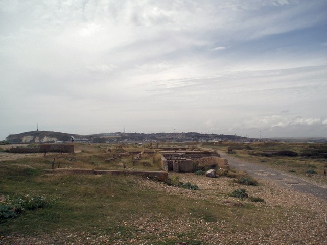
The ruins show very weathered concrete foundations onto which were fixed what appear to be wooden buildings. Plaques on the site show beds wheeled into the fresh air - "Nature's
Antibiotic". Very close to, and on the landward side of the hospital, was the Lily Warren nurses' home.
222:
43:
951:== {{int:filedesc}} == {{Information |description={{en|1=Ruins of Chailey Heritage Marine Hospital The hospital was built in 1924, to provide aftercare and recovery for disabled boys who had undergone surgery. Plaques on the site speak of a charitable fou
83:
51:
414:– You must give appropriate credit, provide a link to the license, and indicate if changes were made. You may do so in any reasonable manner, but not in any way that suggests the licensor endorses you or your use.
829:
644:
127:
Heritage created by Dame Grace
Kimmins in 1903. The nurses home was inland and the hospital built on foundations on the shingle beach itself
933:
928:
42:
965:
764:
630:
594:
296:
246:
814:
331:
1006:
This file contains additional information, probably added from the digital camera or scanner used to create or digitize it.
421:
529:
870:
843:
777:
748:
685:
658:
578:
550:
537:
522:
807:
792:
714:
614:
495:
478:
318:
993:
377:
1009:
If the file has been modified from its original state, some details may not fully reflect the modified file.
420:– If you remix, transform, or build upon the material, you must distribute your contributions under the
338:
on the
Geograph website for the photographer's contact details. The copyright on this image is owned by
944:
374:
836:"}},"text\/plain":{"en":{"P7787":"270 degree"}}}}": -->
651:"}},"text\/plain":{"en":{"P7787":"270 degree"}}}}": -->
91:
799:
784:
557:
175:
132:
302:
252:
970:
343:
78:
191:
236:
143:
286:
164:
154:
323:
116:
Ruins of
Chailey Heritage Marine Hospital - geograph.org.uk - 1410294.jpg
52:
Ruins_of_Chailey_Heritage_Marine_Hospital_-_geograph.org.uk_-_1410294.jpg
335:
901:
Click on a date/time to view the file as it appeared at that time.
994:
Wikidata:WikiProject
Medicine/Hospitals by country/United Kingdom
288:
238:
263:
213:
66:
273:
50° 46′ 56″ N, 0° 04′ 11″ E
223:
50° 46′ 56″ N, 0° 04′ 13″ E
133:
http://en.wikipedia.org/Chailey_Heritage_Marine_Hospital
462:
Add a one-line explanation of what this file represents
988:
110:
90:
Commons is a freely licensed media file repository.
631:
Creative
Commons Attribution-ShareAlike 2.0 Generic
56:(640 × 480 pixels, file size: 56 KB, MIME type:
431:https://creativecommons.org/licenses/by-sa/2.0
71:
437:Creative Commons Attribution-Share Alike 2.0
355:
8:
833:
648:
397:– to copy, distribute and transmit the work
1011:
903:
458:
981:The following other wikis use this file:
800:https://www.geograph.org.uk/photo/1410294
558:https://www.geograph.org.uk/profile/36675
206:Ruins of Chailey Heritage Marine Hospital
187:Ruins of Chailey Heritage Marine Hospital
1013:
963:
857:
841:
762:
746:
728:
712:
672:
656:
628:
612:
592:
576:
509:
493:
476:
473:
454:
447:
266:
216:
295:View this and other nearby images on:
245:View this and other nearby images on:
961:The following 2 pages use this file:
7:
342:and is licensed for reuse under the
892:
378:Attribution-Share Alike 2.0 Generic
366:
361:
346:Attribution-ShareAlike 2.0 license.
1004:
467:
461:
352:
329:
120:
103:
49:
466:
966:Chailey Heritage Marine Hospital
659:coordinates of the point of view
452:
408:Under the following conditions:
373:This file is licensed under the
365:
360:
354:
322:
301:
287:
279:
251:
237:
229:
70:
31:
21:
449:
121:
46:No higher resolution available.
14:
765:file available on the internet
448:
330:This image was taken from the
26:
1:
844:coordinates of depicted place
36:
815:Geograph Britain and Ireland
674:50°46'56.089"N, 0°4'13.296"E
523:object of statement has role
474:Items portrayed in this file
278:
228:
1035:
985:Usage on www.wikidata.org
859:50°46'56.06"N, 0°4'10.92"E
422:same or compatible license
893:
204:Paul Gillett /
185:Paul Gillett /
16:
778:geograph.org.uk image ID
451:
388:
77:This is a file from the
950:
176:required by the license
160:
149:
142:
139:
113:
81:. Information from its
336:this photograph's page
307:50.782240; 0.069700
257:50.782247; 0.070360
84:description page there
929:16:53, 1 March 2011
403:– to adapt the work
538:author name string
1022:
1021:
977:Global file usage
954:
835:
650:
615:copyright license
460:
351:
350:
334:collection. See
312:
311:
262:
261:
211:
210:
179:
99:
98:
79:Wikimedia Commons
32:Global file usage
1026:
1012:
941:
881:
880:
875:
817:
812:
802:
797:
793:described at URL
787:
782:
696:
695:
690:
579:copyright status
560:
555:
545:
542:
532:
527:
444:
441:
438:
435:
432:
424:as the original.
386:
375:Creative Commons
369:
368:
364:
363:
358:
357:
344:Creative Commons
332:Geograph project
326:
319:
308:
305:
291:
290:
284:
283:
282:
276:
275:
264:
258:
255:
241:
240:
234:
233:
232:
226:
225:
214:
173:
145:
125:
117:
111:
95:
74:
73:
67:
61:
59:
1034:
1033:
1029:
1028:
1027:
1025:
1024:
1023:
1000:
975:
955:
947:
939:
895:
894:
891:
890:
889:
888:
887:
886:
885:
884:
883:
882:
878:
876:
873:
864:
863:
862:
860:
850:
849:
848:
846:
827:
826:
825:
824:
823:
822:
821:
820:
819:
818:
813:
810:
804:
803:
798:
795:
789:
788:
783:
780:
771:
770:
769:
767:
755:
754:
753:
751:
740:
739:
738:
737:
736:
735:
734:
733:
731:
721:
720:
719:
717:
706:
705:
704:
703:
702:
701:
700:
699:
698:
697:
693:
691:
688:
679:
678:
677:
675:
665:
664:
663:
661:
642:
641:
640:
639:
638:
637:
636:
635:
633:
621:
620:
619:
617:
606:
605:
604:
603:
602:
601:
600:
599:
597:
585:
584:
583:
581:
570:
569:
568:
567:
566:
565:
564:
563:
562:
561:
556:
553:
547:
546:
543:
540:
534:
533:
528:
525:
516:
515:
514:
512:
502:
501:
500:
498:
487:
486:
485:
484:
483:
481:
465:
464:
463:
446:
445:
442:
439:
436:
433:
430:
429:
387:
384:
381:
370:
347:
317:
306:
280:
271:
270:
267:Object location
256:
230:
221:
220:
217:Camera location
212:
201:
194:
182:
155:geograph.org.uk
135:
115:
108:
101:
100:
89:
88:
87:is shown below.
63:
57:
55:
48:
47:
12:
11:
5:
1032:
1030:
1020:
1019:
1016:
1003:
999:
998:
997:
996:
991:
979:
978:
974:
973:
968:
959:
958:
953:
952:
949:
945:
942:
936:
931:
926:
922:
921:
918:
915:
912:
909:
906:
899:
898:
869:
868:
867:
866:
865:
861:
858:
856:
855:
854:
853:
852:
851:
847:
842:
840:
839:
838:
837:
831:
806:
805:
791:
790:
776:
775:
774:
773:
772:
768:
763:
761:
760:
759:
758:
757:
756:
752:
749:source of file
747:
745:
744:
743:
742:
741:
732:
729:
727:
726:
725:
724:
723:
722:
718:
713:
711:
710:
709:
708:
707:
684:
683:
682:
681:
680:
676:
673:
671:
670:
669:
668:
667:
666:
662:
657:
655:
654:
653:
652:
646:
634:
629:
627:
626:
625:
624:
623:
622:
618:
613:
611:
610:
609:
608:
607:
598:
593:
591:
590:
589:
588:
587:
586:
582:
577:
575:
574:
573:
572:
571:
549:
548:
536:
535:
521:
520:
519:
518:
517:
513:
510:
508:
507:
506:
505:
504:
503:
499:
494:
492:
491:
490:
489:
488:
482:
477:
475:
472:
471:
470:
469:
468:
457:
456:
453:
450:
428:
427:
426:
425:
415:
406:
405:
404:
398:
391:You are free:
382:
372:
371:
353:
349:
348:
327:
316:
313:
310:
309:
299:
293:
268:
260:
259:
249:
243:
218:
209:
208:
202:
199:
196:
195:
190:
183:
180:
168:
167:
162:
158:
157:
151:
147:
146:
141:
137:
136:
118:
109:
107:
104:
102:
97:
96:
75:
65:
64:
45:
41:
40:
39:
34:
29:
24:
19:
13:
10:
9:
6:
4:
3:
2:
1031:
1017:
1014:
1010:
1007:
1001:
995:
992:
990:
987:
986:
984:
983:
982:
976:
972:
971:Grace Kimmins
969:
967:
964:
962:
956:
948:
943:
937:
935:
932:
930:
927:
924:
923:
919:
916:
913:
910:
907:
905:
904:
902:
896:
872:
845:
816:
809:
801:
794:
786:
779:
766:
750:
716:
687:
660:
632:
616:
596:
580:
559:
552:
539:
531:
524:
497:
480:
434:CC BY-SA 2.0
423:
419:
416:
413:
410:
409:
407:
402:
399:
396:
393:
392:
390:
389:
383:Attribution:
379:
376:
359:
345:
341:
337:
333:
328:
325:
321:
320:
314:
304:
300:
298:
297:OpenStreetMap
294:
292:
274:
269:
265:
254:
250:
248:
247:OpenStreetMap
244:
242:
224:
219:
215:
207:
203:
198:
197:
193:
189: /
188:
184:
177:
172:
170:
169:
166:
163:
159:
156:
152:
148:
138:
134:
131:
124:
119:
112:
105:
93:
86:
85:
80:
76:
69:
68:
62:
53:
44:
38:
35:
33:
30:
28:
25:
23:
20:
18:
15:
1008:
1005:
980:
960:
900:
897:File history
730:22 July 2009
544:Paul Gillett
530:photographer
417:
411:
400:
394:
385:Paul Gillett
340:Paul Gillett
339:
277:
227:
205:
192:CC BY-SA 2.0
186:
165:Paul Gillett
144:22 July 2009
128:
122:
92:You can help
82:
50:
22:File history
946:GeographBot
595:copyrighted
418:share alike
412:attribution
171:Attribution
114:Description
1015:_error
957:File usage
938:640 × 480
914:Dimensions
511:some value
58:image/jpeg
27:File usage
911:Thumbnail
908:Date/Time
715:inception
315:Licensing
200:InfoField
181:InfoField
123:English:
1002:Metadata
989:Q5067789
808:operator
455:Captions
401:to remix
395:to share
380:license.
37:Metadata
940:(56 KB)
925:current
920:Comment
871:heading
830:heading
785:1410294
686:heading
645:heading
496:creator
479:depicts
459:English
106:Summary
54:
879:degree
834:degree
694:degree
649:degree
285:
235:
161:Author
150:Source
153:From
917:User
877:270
692:270
443:true
440:true
140:Date
17:File
551:URL
874::
811::
796::
781::
689::
554::
541::
526::
1018:0
178:)
174:(
94:.
60:)
Text is available under the Creative Commons Attribution-ShareAlike License. Additional terms may apply.
_heading:270.00&language=en)
_heading:270.00&language=en)
