291:
224:
390:
238:
259:
297:
302:
72:
891:
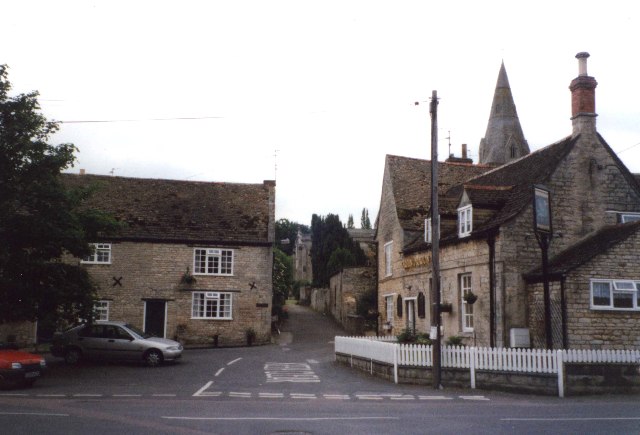
908:== {{int:filedesc}} == {{Information |description={{en|1=Ryhall. The centre of the village; the path straight forwards leads into the churchyard. The road to the left was a dead end on the 1940s map but now goes through a housing estate to the A6121. Th
126:
Ryhall. The centre of the village; the path straight forwards leads into the churchyard. The road to the left was a dead end on the 1940s map but now goes through a housing estate to the A6121. The church of St John
Evangelist is largely
215:
349:– You must give appropriate credit, provide a link to the license, and indicate if changes were made. You may do so in any reasonable manner, but not in any way that suggests the licensor endorses you or your use.
43:
415:
398:
83:
51:
717:
681:
645:
231:
737:
266:
993:
This file contains additional information, probably added from the digital camera or scanner used to create or digitize it.
356:
608:
822:
745:
701:
629:
601:
588:
573:
491:
788:
760:
730:
665:
546:
529:
438:
430:
253:
312:
996:
If the file has been modified from its original state, some details may not fully reflect the modified file.
411:
918:
The following pages on the
English Knowledge (XXG) use this file (pages on other projects are not listed):
355:– If you remix, transform, or build upon the material, you must distribute your contributions under the
273:
on the
Geograph website for the photographer's contact details. The copyright on this image is owned by
901:
890:
885:
42:
309:
419:
91:
184:
404:
Remove redundant categories and try to put this image in the most specific category/categories
580:
168:
767:
752:
482:
486:
478:
474:
470:
466:
462:
458:
454:
450:
446:
237:
278:
78:
950:
221:
136:
157:
147:
258:
922:
270:
858:
Click on a date/time to view the file as it appeared at that time.
223:
206:
66:
815:
216:
52° 41′ 07″ N, 0° 28′ 05″ W
513:
Add a one-line explanation of what this file represents
418:
combined with a database. You can also have a look at
410:
The location categories are based on information from
110:
90:
Commons is a freely licensed media file repository.
980:
970:
960:
940:
682:
Creative
Commons Attribution-ShareAlike 2.0 Generic
56:(640 × 435 pixels, file size: 51 KB, MIME type:
395:The categories of this image should be checked.
366:https://creativecommons.org/licenses/by-sa/2.0
71:
372:Creative Commons Attribution-Share Alike 2.0
290:
8:
332:– to copy, distribute and transmit the work
998:
860:
509:
490:
933:The following other wikis use this file:
581:https://www.geograph.org.uk/profile/1712
1000:
920:
836:
820:
802:
786:
768:https://www.geograph.org.uk/photo/63329
715:
699:
679:
663:
643:
627:
560:
544:
527:
524:
505:
498:
437:This image was uploaded as part of the
209:
230:View this and other nearby images on:
425:The topic category from Geograph was
7:
277:and is licensed for reuse under the
116:Ryhall - geograph.org.uk - 63329.jpg
52:Ryhall_-_geograph.org.uk_-_63329.jpg
849:
313:Attribution-Share Alike 2.0 Generic
301:
296:
281:Attribution-ShareAlike 2.0 license.
991:
518:
512:
287:
264:
120:
103:
49:
517:
503:
388:
343:Under the following conditions:
308:This file is licensed under the
300:
295:
289:
257:
236:
222:
70:
31:
21:
500:
121:
46:No higher resolution available.
14:
718:file available on the internet
499:
265:This image was taken from the
26:
1:
823:coordinates of depicted place
36:
738:Geograph Britain and Ireland
602:object of statement has role
525:Items portrayed in this file
197:Humphrey Bolton /
178:Humphrey Bolton /
1022:
977:Usage on tr.wikipedia.org
967:Usage on nl.wikipedia.org
957:Usage on it.wikipedia.org
947:Usage on fa.wikipedia.org
937:Usage on eu.wikipedia.org
357:same or compatible license
850:
16:
746:geograph.org.uk image ID
502:
420:this tool from mysociety
386:
385:
323:
77:This is a file from the
907:
838:52°41'7.4"N, 0°28'4.8"W
416:this OpenStreetMap tool
169:required by the license
153:
142:
135:
132:
113:
81:. Information from its
886:18:33, 30 January 2010
271:this photograph's page
242:52.685400; -0.468000
84:description page there
439:Geograph batch upload
429:(find similar images
407:Remove this template
483:português do Brasil
338:– to adapt the work
589:author name string
412:this geonames tool
1009:
1008:
929:Global file usage
911:
666:copyright license
511:
494:
441:
286:
285:
269:collection. See
247:
246:
204:
203:
172:
99:
98:
79:Wikimedia Commons
32:Global file usage
1013:
999:
898:
770:
765:
761:described at URL
755:
750:
740:
735:
630:copyright status
611:
606:
596:
593:
583:
578:
495:
436:
393:
392:
391:
379:
376:
373:
370:
367:
359:as the original.
321:
310:Creative Commons
304:
303:
299:
298:
293:
292:
279:Creative Commons
267:Geograph project
261:
254:
243:
240:
226:
225:
219:
218:
207:
166:
138:
125:
117:
111:
95:
74:
73:
67:
61:
59:
1021:
1020:
1016:
1015:
1014:
1012:
1011:
1010:
987:
927:
919:
912:
904:
896:
852:
851:
848:
847:
846:
845:
844:
843:
842:
841:
839:
829:
828:
827:
825:
814:
813:
812:
811:
810:
809:
808:
807:
805:
795:
794:
793:
791:
780:
779:
778:
777:
776:
775:
774:
773:
772:
771:
766:
763:
757:
756:
751:
748:
742:
741:
736:
733:
724:
723:
722:
720:
708:
707:
706:
704:
693:
692:
691:
690:
689:
688:
687:
686:
684:
672:
671:
670:
668:
657:
656:
655:
654:
653:
652:
651:
650:
648:
636:
635:
634:
632:
621:
620:
619:
618:
617:
616:
615:
614:
613:
612:
607:
604:
598:
597:
595:Humphrey Bolton
594:
591:
585:
584:
579:
576:
567:
566:
565:
563:
553:
552:
551:
549:
538:
537:
536:
535:
534:
532:
516:
515:
514:
497:
445:
442:
399:Check them now!
389:
387:
381:
380:
377:
374:
371:
368:
365:
364:
322:
320:Humphrey Bolton
319:
316:
305:
282:
275:Humphrey Bolton
252:
241:
214:
213:
210:Object location
205:
194:
187:
175:
158:Humphrey Bolton
148:geograph.org.uk
128:
115:
108:
101:
100:
89:
88:
87:is shown below.
63:
57:
55:
48:
47:
12:
11:
5:
1019:
1017:
1007:
1006:
1003:
990:
986:
985:
984:
983:
975:
974:
973:
965:
964:
963:
955:
954:
953:
945:
944:
943:
931:
930:
926:
925:
917:
916:
915:
910:
909:
906:
902:
899:
893:
888:
883:
879:
878:
875:
872:
869:
866:
863:
856:
855:
840:
837:
835:
834:
833:
832:
831:
830:
826:
821:
819:
818:
817:
816:
806:
803:
801:
800:
799:
798:
797:
796:
792:
787:
785:
784:
783:
782:
781:
759:
758:
744:
743:
729:
728:
727:
726:
725:
721:
716:
714:
713:
712:
711:
710:
709:
705:
702:source of file
700:
698:
697:
696:
695:
694:
685:
680:
678:
677:
676:
675:
674:
673:
669:
664:
662:
661:
660:
659:
658:
649:
644:
642:
641:
640:
639:
638:
637:
633:
628:
626:
625:
624:
623:
622:
600:
599:
587:
586:
572:
571:
570:
569:
568:
564:
561:
559:
558:
557:
556:
555:
554:
550:
545:
543:
542:
541:
540:
539:
533:
528:
526:
523:
522:
521:
520:
519:
508:
507:
504:
501:
435:
434:
423:
408:
405:
363:
362:
361:
360:
350:
341:
340:
339:
333:
326:You are free:
317:
307:
306:
288:
284:
283:
262:
251:
248:
245:
244:
234:
228:
211:
202:
201:
195:
192:
189:
188:
183:
176:
173:
161:
160:
155:
151:
150:
144:
140:
139:
134:
130:
129:
118:
109:
107:
104:
102:
97:
96:
75:
65:
64:
45:
41:
40:
39:
34:
29:
24:
19:
13:
10:
9:
6:
4:
3:
2:
1018:
1004:
1001:
997:
994:
988:
982:
979:
978:
976:
972:
969:
968:
966:
962:
959:
958:
956:
952:
949:
948:
946:
942:
939:
938:
936:
935:
934:
928:
924:
921:
913:
905:
900:
894:
892:
889:
887:
884:
881:
880:
876:
873:
870:
867:
864:
862:
861:
859:
853:
824:
790:
769:
762:
754:
747:
739:
732:
719:
703:
683:
667:
647:
631:
610:
603:
590:
582:
575:
548:
531:
496:
493:
488:
484:
480:
476:
472:
468:
464:
460:
456:
452:
448:
443:
440:
432:
428:
424:
421:
417:
413:
409:
406:
403:
402:
401:
400:
396:
384:
383:
369:CC BY-SA 2.0
358:
354:
351:
348:
345:
344:
342:
337:
334:
331:
328:
327:
325:
324:
318:Attribution:
314:
311:
294:
280:
276:
272:
268:
263:
260:
256:
255:
249:
239:
235:
233:
232:OpenStreetMap
229:
227:
217:
212:
208:
200:
196:
191:
190:
186:
182: /
181:
177:
170:
165:
163:
162:
159:
156:
152:
149:
145:
141:
131:
124:
119:
112:
105:
93:
86:
85:
80:
76:
69:
68:
62:
53:
44:
38:
35:
33:
30:
28:
25:
23:
20:
18:
15:
995:
992:
932:
857:
854:File history
609:photographer
444:
426:
397:
394:
382:
352:
346:
335:
329:
274:
198:
185:CC BY-SA 2.0
179:
122:
92:You can help
82:
50:
22:File history
903:GeographBot
646:copyrighted
431:at Geograph
353:share alike
347:attribution
164:Attribution
114:Description
1002:_error
914:File usage
895:640 × 435
871:Dimensions
562:some value
471:македонски
58:image/jpeg
27:File usage
868:Thumbnail
865:Date/Time
804:June 1999
789:inception
479:português
250:Licensing
193:InfoField
174:InfoField
137:June 1999
123:English:
989:Metadata
731:operator
506:Captions
489: |
485: |
481: |
477: |
473: |
469: |
465: |
461: |
457: |
455:français
453: |
449: |
336:to remix
330:to share
315:license.
37:Metadata
897:(51 KB)
882:current
877:Comment
547:creator
530:depicts
510:English
447:English
427:Village
106:Summary
54:
981:Ryhall
971:Ryhall
961:Ryhall
951:رایهال
941:Ryhall
923:Ryhall
487:Türkçe
475:മലയാളം
467:magyar
459:galego
220:
199:Ryhall
180:Ryhall
154:Author
143:Source
753:63329
463:עברית
451:suomi
146:From
874:User
414:and
378:true
375:true
133:Date
127:13C.
17:File
574:URL
492:+/−
764::
749::
734::
605::
592::
577::
1005:0
433:)
422:.
171:)
167:(
94:.
60:)
Text is available under the Creative Commons Attribution-ShareAlike License. Additional terms may apply.
_&language=en)
