291:
224:
238:
259:
297:
302:
72:
883:
900:== {{int:filedesc}} == {{Information |description={{en|1=Warwick - County Museum. This building was erected in 1670 as the Market Hall. The arches were originally open but today they house the County Museum with local and natural history collections, the
215:
126:
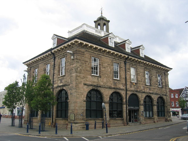
Warwick - County Museum. This building was erected in 1670 as the Market Hall. The arches were originally open but today they house the County Museum with local and natural history collections, the great
Sheldon Tapestry and the huge Warwickshire
43:
349:– You must give appropriate credit, provide a link to the license, and indicate if changes were made. You may do so in any reasonable manner, but not in any way that suggests the licensor endorses you or your use.
83:
51:
601:
565:
529:
231:
636:
1046:
266:
938:
This file contains additional information, probably added from the digital camera or scanner used to create or digitize it.
356:
464:
811:
777:
740:
706:
614:
585:
513:
485:
472:
457:
882:
877:
42:
672:
644:
629:
549:
430:
413:
253:
312:
941:
If the file has been modified from its original state, some details may not fully reflect the modified file.
960:
1091:
355:– If you remix, transform, or build upon the material, you must distribute your contributions under the
273:
on the
Geograph website for the photographer's contact details. The copyright on this image is owned by
893:
309:
1119:
91:
184:
910:
No pages on the
English Knowledge (XXG) use this file (pages on other projects are not listed).
168:
950:
651:
621:
492:
237:
1187:
1109:
1073:
967:
278:
78:
1197:
996:
1129:
136:
221:
157:
147:
977:
258:
270:
850:
Click on a date/time to view the file as it appeared at that time.
223:
206:
66:
699:
216:
52° 16′ 55″ N, 1° 35′ 24″ W
397:
Add a one-line explanation of what this file represents
925:
116:
Warwick - County Museum - geograph.org.uk - 15433.jpg
52:
Warwick_-_County_Museum_-_geograph.org.uk_-_15433.jpg
110:
90:
Commons is a freely licensed media file repository.
566:
Creative
Commons Attribution-ShareAlike 2.0 Generic
56:(640 × 480 pixels, file size: 90 KB, MIME type:
366:https://creativecommons.org/licenses/by-sa/2.0
71:
372:Creative Commons Attribution-Share Alike 2.0
290:
8:
332:– to copy, distribute and transmit the work
943:
852:
393:
918:The following other wikis use this file:
1206:
1195:
1185:
1177:
1169:
1161:
1153:
1145:
1137:
1127:
1117:
1107:
1099:
1089:
1081:
1071:
1063:
1055:
1044:
1036:
1028:
1020:
1012:
1004:
993:
985:
975:
965:
955:
825:
809:
791:
775:
754:
738:
720:
704:
686:
670:
652:https://www.geograph.org.uk/photo/15433
599:
583:
563:
547:
527:
511:
493:https://www.geograph.org.uk/profile/120
444:
428:
411:
408:
389:
382:
209:
230:View this and other nearby images on:
945:
7:
277:and is licensed for reuse under the
841:
313:Attribution-Share Alike 2.0 Generic
301:
296:
281:Attribution-ShareAlike 2.0 license.
936:
402:
396:
287:
264:
120:
103:
49:
401:
987:Date and time of data generation
387:
343:Under the following conditions:
308:This file is licensed under the
300:
295:
289:
257:
236:
222:
70:
31:
21:
384:
121:
46:No higher resolution available.
14:
602:file available on the internet
383:
265:This image was taken from the
26:
1:
1124:Flash did not fire, auto mode
707:coordinates of depicted place
36:
637:Geograph Britain and Ireland
458:object of statement has role
409:Items portrayed in this file
1155:Focal plane resolution unit
1057:Date and time of digitizing
1228:
1166:One-chip color area sensor
922:Usage on www.wikidata.org
357:same or compatible license
197:David Stowell /
178:David Stowell /
1030:File change date and time
842:
722:52°16'55.2"N, 1°35'24.0"W
16:
1147:Focal plane Y resolution
1139:Focal plane X resolution
615:geograph.org.uk image ID
386:
323:
77:This is a file from the
1171:Custom image processing
899:
199:Warwick - County Museum
180:Warwick - County Museum
169:required by the license
153:
142:
135:
132:
113:
81:. Information from its
1065:Image compression mode
961:Canon DIGITAL IXUS 500
878:05:44, 30 January 2010
271:this photograph's page
242:52.282000; -1.590000
84:description page there
1101:Maximum land aperture
1014:Horizontal resolution
1104:2.96875 APEX (f/2.8)
1038:Y and C positioning
1022:Vertical resolution
947:Camera manufacturer
338:– to adapt the work
1208:Scene capture type
1192:Auto white balance
1060:09:26, 5 June 2005
1033:09:26, 5 June 2005
990:09:26, 5 June 2005
473:author name string
1215:
1214:
972:1/125 sec (0.008)
914:Global file usage
903:
550:copyright license
395:
286:
285:
269:collection. See
247:
246:
204:
203:
172:
99:
98:
79:Wikimedia Commons
32:Global file usage
1219:
1150:7,245.2830188679
1142:7,236.7491166078
944:
890:
830:
759:
654:
649:
645:described at URL
639:
634:
624:
619:
514:copyright status
495:
490:
480:
477:
467:
462:
379:
376:
373:
370:
367:
359:as the original.
321:
310:Creative Commons
304:
303:
299:
298:
293:
292:
279:Creative Commons
267:Geograph project
261:
254:
243:
240:
226:
225:
219:
218:
207:
166:
138:
125:
117:
111:
95:
74:
73:
67:
61:
59:
1227:
1226:
1222:
1221:
1220:
1218:
1217:
1216:
932:
912:
911:
904:
896:
888:
844:
843:
840:
839:
838:
837:
836:
835:
834:
833:
831:
828:
818:
817:
816:
814:
803:
802:
801:
800:
799:
798:
797:
796:
794:
784:
783:
782:
780:
769:
768:
767:
766:
765:
764:
763:
762:
760:
757:
747:
746:
745:
743:
732:
731:
730:
729:
728:
727:
726:
725:
723:
713:
712:
711:
709:
698:
697:
696:
695:
694:
693:
692:
691:
689:
679:
678:
677:
675:
664:
663:
662:
661:
660:
659:
658:
657:
656:
655:
650:
647:
641:
640:
635:
632:
626:
625:
620:
617:
608:
607:
606:
604:
592:
591:
590:
588:
577:
576:
575:
574:
573:
572:
571:
570:
568:
556:
555:
554:
552:
541:
540:
539:
538:
537:
536:
535:
534:
532:
520:
519:
518:
516:
505:
504:
503:
502:
501:
500:
499:
498:
497:
496:
491:
488:
482:
481:
478:
475:
469:
468:
463:
460:
451:
450:
449:
447:
437:
436:
435:
433:
422:
421:
420:
419:
418:
416:
400:
399:
398:
381:
380:
377:
374:
371:
368:
365:
364:
322:
319:
316:
305:
282:
252:
241:
214:
213:
210:Object location
205:
194:
187:
175:
148:geograph.org.uk
128:
115:
108:
101:
100:
89:
88:
87:is shown below.
63:
57:
55:
48:
47:
12:
11:
5:
1225:
1223:
1213:
1212:
1209:
1205:
1204:
1201:
1194:
1193:
1190:
1184:
1183:
1180:
1176:
1175:
1174:Normal process
1172:
1168:
1167:
1164:
1163:Sensing method
1160:
1159:
1156:
1152:
1151:
1148:
1144:
1143:
1140:
1136:
1135:
1132:
1126:
1125:
1122:
1116:
1115:
1112:
1106:
1105:
1102:
1098:
1097:
1094:
1088:
1087:
1084:
1080:
1079:
1076:
1070:
1069:
1066:
1062:
1061:
1058:
1054:
1053:
1050:
1043:
1042:
1039:
1035:
1034:
1031:
1027:
1026:
1023:
1019:
1018:
1015:
1011:
1010:
1007:
1003:
1002:
999:
992:
991:
988:
984:
983:
980:
974:
973:
970:
964:
963:
958:
954:
953:
948:
935:
931:
930:
929:
928:
916:
915:
909:
908:
907:
902:
901:
898:
894:
891:
885:
880:
875:
871:
870:
867:
864:
861:
858:
855:
848:
847:
832:
826:
824:
823:
822:
821:
820:
819:
815:
810:
808:
807:
806:
805:
804:
795:
792:
790:
789:
788:
787:
786:
785:
781:
776:
774:
773:
772:
771:
770:
761:
755:
753:
752:
751:
750:
749:
748:
744:
739:
737:
736:
735:
734:
733:
724:
721:
719:
718:
717:
716:
715:
714:
710:
705:
703:
702:
701:
700:
690:
687:
685:
684:
683:
682:
681:
680:
676:
671:
669:
668:
667:
666:
665:
643:
642:
628:
627:
613:
612:
611:
610:
609:
605:
600:
598:
597:
596:
595:
594:
593:
589:
586:source of file
584:
582:
581:
580:
579:
578:
569:
564:
562:
561:
560:
559:
558:
557:
553:
548:
546:
545:
544:
543:
542:
533:
528:
526:
525:
524:
523:
522:
521:
517:
512:
510:
509:
508:
507:
506:
484:
483:
471:
470:
456:
455:
454:
453:
452:
448:
445:
443:
442:
441:
440:
439:
438:
434:
429:
427:
426:
425:
424:
423:
417:
412:
410:
407:
406:
405:
404:
403:
392:
391:
388:
385:
363:
362:
361:
360:
350:
341:
340:
339:
333:
326:You are free:
317:
307:
306:
288:
284:
283:
262:
251:
248:
245:
244:
234:
228:
211:
202:
201:
195:
192:
189:
188:
183:
176:
173:
161:
160:
155:
151:
150:
144:
140:
139:
134:
130:
129:
118:
109:
107:
104:
102:
97:
96:
75:
65:
64:
45:
41:
40:
39:
34:
29:
24:
19:
13:
10:
9:
6:
4:
3:
2:
1224:
1210:
1207:
1202:
1199:
1196:
1191:
1189:
1188:White balance
1186:
1182:Auto exposure
1181:
1179:Exposure mode
1178:
1173:
1170:
1165:
1162:
1157:
1154:
1149:
1146:
1141:
1138:
1133:
1131:
1128:
1123:
1121:
1118:
1113:
1111:
1110:Metering mode
1108:
1103:
1100:
1095:
1093:
1092:Exposure bias
1090:
1085:
1083:APEX aperture
1082:
1077:
1075:
1074:Shutter speed
1072:
1067:
1064:
1059:
1056:
1051:
1048:
1045:
1040:
1037:
1032:
1029:
1024:
1021:
1016:
1013:
1008:
1005:
1000:
998:
994:
989:
986:
981:
979:
976:
971:
969:
968:Exposure time
966:
962:
959:
956:
952:
949:
946:
942:
939:
933:
927:
924:
923:
921:
920:
919:
913:
905:
897:
892:
886:
884:
881:
879:
876:
873:
872:
868:
865:
862:
859:
856:
854:
853:
851:
845:
813:
779:
742:
741:exposure time
708:
674:
653:
646:
638:
631:
623:
616:
603:
587:
567:
551:
531:
515:
494:
487:
479:David Stowell
474:
466:
459:
432:
415:
369:CC BY-SA 2.0
358:
354:
351:
348:
345:
344:
342:
337:
334:
331:
328:
327:
325:
324:
320:David Stowell
318:Attribution:
314:
311:
294:
280:
276:
275:David Stowell
272:
268:
263:
260:
256:
255:
249:
239:
235:
233:
232:OpenStreetMap
229:
227:
217:
212:
208:
200:
196:
191:
190:
186:
182: /
181:
177:
170:
165:
163:
162:
159:
158:David Stowell
156:
152:
149:
145:
141:
131:
124:
119:
112:
105:
93:
86:
85:
80:
76:
69:
68:
62:
53:
44:
38:
35:
33:
30:
28:
25:
23:
20:
18:
15:
1198:Digital zoom
997:focal length
957:Camera model
940:
937:
917:
849:
846:File history
812:focal length
465:photographer
352:
346:
335:
329:
274:
198:
185:CC BY-SA 2.0
179:
122:
92:You can help
82:
50:
22:File history
1130:Color space
1006:Orientation
895:GeographBot
688:5 June 2005
530:copyrighted
353:share alike
347:attribution
164:Attribution
137:5 June 2005
114:Description
1001:7.40625 mm
906:File usage
887:640 × 480
863:Dimensions
829:millimetre
446:some value
58:image/jpeg
27:File usage
926:Q15961647
860:Thumbnail
857:Date/Time
673:inception
250:Licensing
193:InfoField
174:InfoField
123:English:
1211:Standard
1041:Centered
978:F-number
934:Metadata
827:7.40625
778:f-number
630:operator
390:Captions
336:to remix
330:to share
315:license.
37:Metadata
1114:Pattern
1086:5.65625
1078:6.96875
1049:version
1025:180 dpi
1017:180 dpi
889:(90 KB)
874:current
869:Comment
431:creator
414:depicts
394:English
106:Summary
54:
1158:inches
1009:Normal
758:second
756:0.008
220:
154:Author
143:Source
1200:ratio
1120:Flash
995:Lens
982:f/7.1
951:Canon
622:15433
146:From
1134:sRGB
1047:Exif
866:User
378:true
375:true
133:Date
127:Bear
17:File
1052:2.2
793:7.1
486:URL
648::
633::
618::
489::
476::
461::
1203:1
1096:0
1068:3
171:)
167:(
94:.
60:)
Text is available under the Creative Commons Attribution-ShareAlike License. Additional terms may apply.
_&language=en)
