377:
312:
262:
304:
254:
326:
276:
345:
383:
388:
87:
43:
872:"}},"text\/plain":{"en":{"":"heading"}}},"{\"value\":{\"amount\":\"+45\",\"unit\":\"http:\\\/\\\/www.wikidata.org\\\/entity\\\/Q28390\"},\"type\":\"quantity\"}":{"text\/html":{"en":{"P7787":"45
808:"}},"text\/plain":{"en":{"":"heading"}}},"{\"value\":{\"amount\":\"+45\",\"unit\":\"http:\\\/\\\/www.wikidata.org\\\/entity\\\/Q28390\"},\"type\":\"quantity\"}":{"text\/html":{"en":{"P7787":"45
868:
295:
245:
435:– You must give appropriate credit, provide a link to the license, and indicate if changes were made. You may do so in any reasonable manner, but not in any way that suggests the licensor endorses you or your use.
1056:
869:
805:
53:
47:
98:
66:
1041:
1027:{{Information |Description={{en|1=Church of All Saints in Wetheringsett, Suffolk, England. A Grade I listed medieval church.}} |Source= |Author=
740:
670:
634:
515:
319:
269:
955:
790:
352:
1107:
This file contains additional information, probably added from the digital camera or scanner used to create or digitize it.
442:
569:
939:
910:
883:
846:
819:
768:
724:
618:
592:
577:
562:
1051:
783:
753:
690:
654:
535:
499:
339:
398:
1110:
If the file has been modified from its original state, some details may not fully reflect the modified file.
1037:
The following pages on the
English Knowledge (XXG) use this file (pages on other projects are not listed):
1009:
1004:
57:
42:
441:– If you remix, transform, or build upon the material, you must distribute your contributions under the
359:
on the
Geograph website for the photographer's contact details. The copyright on this image is owned by
395:
130:
876:"}},"text\/plain":{"en":{"P7787":"45 degree"}}}}": -->
812:"}},"text\/plain":{"en":{"P7787":"45 degree"}}}}": -->
106:
214:
125:
775:
760:
584:
198:
158:
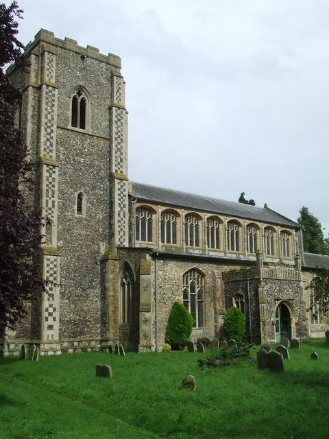
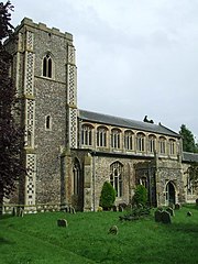
Church of All Saints in
Wetheringsett, Suffolk, England. A Grade I listed medieval church.
325:
275:
1046:
364:
93:
167:
1020:
309:
259:
187:
177:
344:
356:
977:
Click on a date/time to view the file as it appeared at that time.
311:
261:
286:
236:
81:
1084:
1074:
296:
52° 15′ 32″ N, 1° 06′ 56″ E
246:
52° 15′ 31″ N, 1° 06′ 55″ E
483:
Add a one-line explanation of what this file represents
1094:
142:
119:
105:
Commons is a freely licensed media file repository.
671:
Creative
Commons Attribution-ShareAlike 2.0 Generic
1057:User:Nev1/Grade I listed buildings in Mid Suffolk
71:(480 × 640 pixels, file size: 83 KB, MIME type:
452:https://creativecommons.org/licenses/by-sa/2.0
86:
458:Creative Commons Attribution-Share Alike 2.0
376:
337:Commons Attribution Share-alike license 2.0
8:
873:
809:
418:– to copy, distribute and transmit the work
1112:
979:
479:
1067:The following other wikis use this file:
761:https://www.geograph.org.uk/photo/954027
585:https://www.geograph.org.uk/profile/6337
148:Wetheringsett - Church of All Saints.jpg
1114:
1042:Grade I listed buildings in Mid Suffolk
1039:
953:
937:
897:
881:
833:
817:
738:
722:
704:
688:
668:
652:
632:
616:
549:
533:
513:
497:
494:
475:
468:
289:
239:
318:View this and other nearby images on:
268:View this and other nearby images on:
7:
363:and is licensed for reuse under the
968:
399:Attribution-Share Alike 2.0 Generic
387:
382:
367:Attribution-ShareAlike 2.0 license.
1105:
488:
482:
373:
350:
152:
123:
118:
64:
487:
820:coordinates of the point of view
473:
429:Under the following conditions:
394:This file is licensed under the
386:
381:
375:
343:
324:
310:
302:
274:
260:
252:
85:
31:
21:
470:
153:
14:
741:file available on the internet
469:
351:This image was taken from the
26:
1:
884:coordinates of depicted place
36:
791:Geograph Britain and Ireland
563:object of statement has role
495:Items portrayed in this file
1052:Wetheringsett-cum-Brockford
301:
251:
1136:
1091:Usage on www.wikidata.org
1081:Usage on sv.wikipedia.org
1071:Usage on pl.wikipedia.org
899:52°15'32.00"N, 1°6'55.80"E
835:52°15'31.07"N, 1°6'54.72"E
443:same or compatible license
969:
16:
769:geograph.org.uk image ID
472:
409:
229:All Saints Wetheringsett
227:Keith Evans /
210:All Saints Wetheringsett
208:Keith Evans /
92:This is a file from the
1026:
199:required by the license
183:
173:
166:
163:
145:
96:. Information from its
357:this photograph's page
330:52.258890; 1.115500
280:52.258630; 1.115200
99:description page there
46:Size of this preview:
940:location of creation
516:Church of All Saints
424:– to adapt the work
124:This is a photo of
52:Other resolutions:
1005:22:54, 9 July 2009
593:author name string
1123:
1122:
1063:Global file usage
1030:
875:
811:
655:copyright license
481:
372:
371:
355:collection. See
335:
334:
285:
284:
234:
233:
202:
140:
139:
114:
113:
94:Wikimedia Commons
32:Global file usage
1127:
1113:
1017:
921:
920:
915:
857:
856:
851:
793:
788:
778:
773:
763:
758:
754:described at URL
706:7 September 2008
619:copyright status
600:
597:
587:
582:
572:
567:
465:
462:
459:
456:
453:
445:as the original.
407:
396:Creative Commons
390:
389:
385:
384:
379:
378:
365:Creative Commons
353:Geograph project
347:
340:
331:
328:
314:
313:
307:
306:
305:
299:
298:
287:
281:
278:
264:
263:
257:
256:
255:
249:
248:
237:
196:
169:
168:7 September 2008
157:
149:
143:
133:
120:
110:
89:
88:
82:
76:
74:
61:
58:480 × 640 pixels
54:180 × 240 pixels
48:450 × 600 pixels
1135:
1134:
1130:
1129:
1128:
1126:
1125:
1124:
1101:
1061:
1038:
1031:
1023:
1015:
971:
970:
967:
966:
965:
964:
963:
962:
961:
960:
958:
946:
945:
944:
942:
931:
930:
929:
928:
927:
926:
925:
924:
923:
922:
918:
916:
913:
904:
903:
902:
900:
890:
889:
888:
886:
867:
866:
865:
864:
863:
862:
861:
860:
859:
858:
854:
852:
849:
840:
839:
838:
836:
826:
825:
824:
822:
803:
802:
801:
800:
799:
798:
797:
796:
795:
794:
789:
786:
780:
779:
774:
771:
765:
764:
759:
756:
747:
746:
745:
743:
731:
730:
729:
727:
716:
715:
714:
713:
712:
711:
710:
709:
707:
697:
696:
695:
693:
682:
681:
680:
679:
678:
677:
676:
675:
673:
661:
660:
659:
657:
646:
645:
644:
643:
642:
641:
640:
639:
637:
625:
624:
623:
621:
610:
609:
608:
607:
606:
605:
604:
603:
602:
601:
598:
595:
589:
588:
583:
580:
574:
573:
568:
565:
556:
555:
554:
552:
542:
541:
540:
538:
527:
526:
525:
524:
523:
522:
521:
520:
518:
506:
505:
504:
502:
486:
485:
484:
467:
466:
463:
460:
457:
454:
451:
450:
408:
405:
402:
391:
368:
329:
303:
294:
293:
290:Object location
279:
253:
244:
243:
240:Camera location
235:
224:
217:
205:
178:geograph.org.uk
159:
147:
135:
129:
126:listed building
116:
115:
104:
103:
102:is shown below.
78:
72:
70:
63:
62:
51:
12:
11:
5:
1133:
1131:
1121:
1120:
1117:
1104:
1100:
1099:
1098:
1097:
1089:
1088:
1087:
1079:
1078:
1077:
1065:
1064:
1060:
1059:
1054:
1049:
1044:
1036:
1035:
1034:
1029:
1028:
1025:
1021:
1018:
1012:
1007:
1002:
998:
997:
994:
991:
988:
985:
982:
975:
974:
959:
954:
952:
951:
950:
949:
948:
947:
943:
938:
936:
935:
934:
933:
932:
909:
908:
907:
906:
905:
901:
898:
896:
895:
894:
893:
892:
891:
887:
882:
880:
879:
878:
877:
871:
845:
844:
843:
842:
841:
837:
834:
832:
831:
830:
829:
828:
827:
823:
818:
816:
815:
814:
813:
807:
782:
781:
767:
766:
752:
751:
750:
749:
748:
744:
739:
737:
736:
735:
734:
733:
732:
728:
725:source of file
723:
721:
720:
719:
718:
717:
708:
705:
703:
702:
701:
700:
699:
698:
694:
689:
687:
686:
685:
684:
683:
674:
669:
667:
666:
665:
664:
663:
662:
658:
653:
651:
650:
649:
648:
647:
638:
633:
631:
630:
629:
628:
627:
626:
622:
617:
615:
614:
613:
612:
611:
591:
590:
576:
575:
561:
560:
559:
558:
557:
553:
550:
548:
547:
546:
545:
544:
543:
539:
534:
532:
531:
530:
529:
528:
519:
514:
512:
511:
510:
509:
508:
507:
503:
498:
496:
493:
492:
491:
490:
489:
478:
477:
474:
471:
449:
448:
447:
446:
436:
427:
426:
425:
419:
412:You are free:
403:
393:
392:
374:
370:
369:
348:
333:
332:
322:
316:
291:
283:
282:
272:
266:
241:
232:
231:
225:
222:
219:
218:
213:
206:
203:
191:
190:
185:
181:
180:
175:
171:
170:
165:
161:
160:
150:
141:
138:
137:
117:
112:
111:
90:
80:
79:
45:
41:
40:
39:
34:
29:
24:
19:
13:
10:
9:
6:
4:
3:
2:
1132:
1118:
1115:
1111:
1108:
1102:
1096:
1093:
1092:
1090:
1086:
1085:Wetheringsett
1083:
1082:
1080:
1076:
1075:Wetheringsett
1073:
1072:
1070:
1069:
1068:
1062:
1058:
1055:
1053:
1050:
1048:
1047:Wetheringsett
1045:
1043:
1040:
1032:
1024:
1019:
1013:
1011:
1008:
1006:
1003:
1000:
999:
995:
992:
989:
986:
983:
981:
980:
978:
972:
957:
941:
912:
885:
848:
821:
792:
785:
777:
770:
762:
755:
742:
726:
692:
672:
656:
636:
620:
594:
586:
579:
571:
564:
537:
517:
501:
455:CC BY-SA 2.0
444:
440:
437:
434:
431:
430:
428:
423:
420:
417:
414:
413:
411:
410:
404:Attribution:
400:
397:
380:
366:
362:
358:
354:
349:
346:
342:
341:
338:
327:
323:
321:
320:OpenStreetMap
317:
315:
297:
292:
288:
277:
273:
271:
270:OpenStreetMap
267:
265:
247:
242:
238:
230:
226:
221:
220:
216:
212: /
211:
207:
200:
195:
193:
192:
189:
186:
182:
179:
176:
172:
162:
156:
151:
144:
136:
132:
127:
122:
121:
108:
101:
100:
95:
91:
84:
83:
77:
68:
67:Original file
59:
55:
49:
44:
38:
35:
33:
30:
28:
25:
23:
20:
18:
15:
1109:
1106:
1066:
976:
973:File history
570:photographer
438:
432:
421:
415:
360:
336:
300:
250:
228:
215:CC BY-SA 2.0
209:
154:
107:You can help
97:
65:
22:File history
956:Mid Suffolk
635:copyrighted
599:Keith Evans
439:share alike
433:attribution
406:Keith Evans
361:Keith Evans
194:Attribution
188:Keith Evans
146:Description
1116:_error
1033:File usage
1014:480 × 640
990:Dimensions
551:some value
73:image/jpeg
27:File usage
1095:Q17526361
987:Thumbnail
984:Date/Time
691:inception
223:InfoField
204:InfoField
155:English:
1103:Metadata
784:operator
476:Captions
422:to remix
416:to share
401:license.
37:Metadata
1016:(83 KB)
1001:current
996:Comment
911:heading
870:heading
847:heading
806:heading
536:creator
500:depicts
480:English
131:1284593
128:number
69:
919:degree
874:degree
855:degree
810:degree
776:954027
308:
258:
184:Author
174:Source
1022:Aldux
993:User
464:true
461:true
164:Date
17:File
917:45
853:45
578:URL
914::
850::
787::
772::
757::
596::
581::
566::
56:|
50:.
1119:0
201:)
197:(
134:.
109:.
75:)
60:.
Text is available under the Creative Commons Attribution-ShareAlike License. Additional terms may apply.
_heading:45.00&language=en)
_heading:45.00&language=en)
