38:
250:
203:
256:
90:
261:
591:
621:
561:
309:– You must give appropriate credit, provide a link to the license, and indicate if changes were made. You may do so in any reasonable manner, but not in any way that suggests the licensor endorses you or your use.
735:
843:
730:
220:
56:
52:
48:
42:
101:
149:
69:
218:; with no Invariant Sections, no Front-Cover Texts, and no Back-Cover Texts. A copy of the license is included in the section entitled
144:
210:
639:
472:
455:
419:
620:
615:
590:
585:
316:
403:
215:
492:
439:
386:
755:
745:
858:
700:
665:
655:
270:
695:
631:
810:
795:
785:
770:
690:
670:
651:
The following pages on the
English Knowledge (XXG) use this file (pages on other projects are not listed):
825:
820:
815:
800:
765:
750:
740:
725:
715:
675:
660:
315:– If you remix, transform, or build upon the material, you must distribute your contributions under the
853:
560:
555:
60:
37:
775:
760:
705:
685:
680:
267:
638:
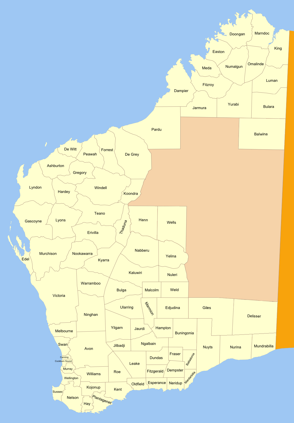
Map of land districts in
Western Australia, as shown on old public domain at the National Library
805:
780:
710:
720:
109:
177:
790:
601:
571:
197:
330:
208:
Permission is granted to copy, distribute and/or modify this document under the terms of the
96:
194:
I, the copyright holder of this work, hereby publish it under the following license:
168:
No machine-readable source provided. Own work assumed (based on copyright claims).
608:
added
Delisser, Giles and Wells; fixed Nuyts; corrected spelling of Koondra
139:
Map of land districts in
Western Australia, as shown on old public domain
528:
Click on a date/time to view the file as it appeared at that time.
140:
329:
This licensing tag was added to this file as part of the GFDL
244:
84:
859:
Divisões administrativas de terras da Austrália
Ocidental
370:
Add a one-line explanation of what this file represents
74:(1,200 × 1,725 pixels, file size: 289 KB, MIME type:
473:
Creative
Commons Attribution-ShareAlike 3.0 Unported
456:
214:, Version 1.2 or any later version published by the
128:
108:
Commons is a freely licensed media file repository.
736:
Lands administrative divisions of
Western Australia
854:Divisões administrativas de terras da Austrália
336:http://creativecommons.org/licenses/by-sa/3.0/
89:
249:
8:
640:Category:Cadastral maps of Western Australia
342:Creative Commons Attribution-Share Alike 3.0
731:Lands administrative divisions of Australia
292:– to copy, distribute and transmit the work
530:
366:
836:The following other wikis use this file:
653:
506:
490:
470:
453:
437:
417:
401:
384:
381:
362:
355:
578:two more corrections, one new district
176:No machine-readable author provided.
7:
271:Attribution-Share Alike 3.0 Unported
226:http://www.gnu.org/copyleft/fdl.html
180:assumed (based on copyright claims).
160:17 March 2007 (original upload date)
134:Western Australia land districts.png
519:
260:
255:
143:at the National Library. made from
375:
369:
193:
121:
67:
374:
360:
303:Under the following conditions:
266:This file is licensed under the
259:
254:
248:
202:
201:
88:
31:
21:
357:
14:
356:
232:GNU Free Documentation License
221:GNU Free Documentation License
211:GNU Free Documentation License
26:
1:
382:Items portrayed in this file
877:
850:Usage on pt.wikipedia.org
840:Usage on fa.wikipedia.org
317:same or compatible license
756:Mundrabilla Land District
746:Mardarbilla Land District
520:
275:
247:
16:
701:Fitzgerald Land District
666:Buningonia Land District
656:Balladonia Land District
359:
216:Free Software Foundation
95:This is a file from the
696:Esperance Land District
637:
607:
586:20:47, 29 November 2010
577:
172:
164:
159:
156:
152:for making locator maps
131:
99:. Information from its
844:تقسیمات کشوری استرالیا
811:Williams Land District
796:Thadoona Land District
786:Oldfield Land District
771:Numalgun Land District
691:Edjudina Land District
671:Delisser Land District
556:21:08, 3 December 2010
102:description page there
41:Size of this preview:
826:Yowalga Land District
821:Yamarna Land District
816:Windell Land District
801:Tugaila Land District
766:Neridup Land District
751:Milyuga Land District
741:Malcolm Land District
726:Koondra Land District
716:Hampton Land District
676:Doongan Land District
661:Balwina Land District
776:Nurina Land District
761:Murray Land District
706:Fraser Land District
686:Easton Land District
681:Dundas Land District
616:00:31, 17 March 2007
61:1,200 × 1,725 pixels
806:Wells Land District
781:Nuyts Land District
711:Giles Land District
298:– to adapt the work
47:Other resolutions:
721:Hann Land District
832:Global file usage
791:Roe Land District
644:
440:copyright license
368:
353:
352:
243:
242:
184:
183:
117:
116:
97:Wikimedia Commons
32:Global file usage
868:
633:Roke~commonswiki
628:
598:
568:
404:copyright status
349:
346:
343:
340:
337:
334:
331:licensing update
319:as the original.
268:Creative Commons
263:
262:
258:
257:
252:
251:
245:
239:
236:
233:
230:
227:
205:
204:
198:
178:Roke~commonswiki
135:
129:
113:
92:
91:
85:
79:
77:
64:
57:534 × 768 pixels
53:334 × 480 pixels
49:167 × 240 pixels
43:417 × 599 pixels
876:
875:
871:
870:
869:
867:
866:
865:
830:
652:
645:
634:
626:
604:
596:
574:
566:
522:
521:
518:
517:
516:
515:
514:
513:
512:
511:
509:
499:
498:
497:
495:
484:
483:
482:
481:
480:
479:
478:
477:
475:
464:
463:
462:
461:
460:
458:
446:
445:
444:
442:
431:
430:
429:
428:
427:
426:
425:
424:
422:
410:
409:
408:
406:
395:
394:
393:
392:
391:
389:
373:
372:
371:
354:
347:
344:
341:
338:
335:
328:
237:
234:
231:
228:
225:
196:
195:
190:
185:
133:
126:
119:
118:
107:
106:
105:is shown below.
81:
75:
73:
66:
65:
46:
12:
11:
5:
874:
872:
864:
863:
862:
861:
856:
848:
847:
846:
834:
833:
829:
828:
823:
818:
813:
808:
803:
798:
793:
788:
783:
778:
773:
768:
763:
758:
753:
748:
743:
738:
733:
728:
723:
718:
713:
708:
703:
698:
693:
688:
683:
678:
673:
668:
663:
658:
650:
649:
648:
643:
642:
636:
632:
629:
625:1,200 × 1,725
623:
618:
613:
610:
609:
606:
602:
599:
595:1,200 × 1,725
593:
588:
583:
580:
579:
576:
572:
569:
565:1,200 × 1,725
563:
558:
553:
549:
548:
545:
542:
539:
536:
533:
526:
525:
510:
507:
505:
504:
503:
502:
501:
500:
496:
491:
489:
488:
487:
486:
485:
476:
471:
469:
468:
467:
466:
465:
459:
454:
452:
451:
450:
449:
448:
447:
443:
438:
436:
435:
434:
433:
432:
423:
418:
416:
415:
414:
413:
412:
411:
407:
402:
400:
399:
398:
397:
396:
390:
385:
383:
380:
379:
378:
377:
376:
365:
364:
361:
358:
351:
350:
325:
324:
323:
322:
321:
320:
310:
301:
300:
299:
293:
286:You are free:
281:
280:
277:
276:
274:
264:
241:
240:
206:
192:
191:
189:
186:
182:
181:
174:
170:
169:
166:
162:
161:
158:
154:
153:
136:
127:
125:
122:
120:
115:
114:
93:
83:
82:
40:
36:
35:
34:
29:
24:
19:
13:
10:
9:
6:
4:
3:
2:
873:
860:
857:
855:
852:
851:
849:
845:
842:
841:
839:
838:
837:
831:
827:
824:
822:
819:
817:
814:
812:
809:
807:
804:
802:
799:
797:
794:
792:
789:
787:
784:
782:
779:
777:
774:
772:
769:
767:
764:
762:
759:
757:
754:
752:
749:
747:
744:
742:
739:
737:
734:
732:
729:
727:
724:
722:
719:
717:
714:
712:
709:
707:
704:
702:
699:
697:
694:
692:
689:
687:
684:
682:
679:
677:
674:
672:
669:
667:
664:
662:
659:
657:
654:
646:
641:
635:
630:
624:
622:
619:
617:
614:
612:
611:
605:
600:
594:
592:
589:
587:
584:
582:
581:
575:
570:
564:
562:
559:
557:
554:
551:
550:
546:
543:
540:
537:
534:
532:
531:
529:
523:
508:17 March 2007
494:
474:
457:
441:
421:
405:
388:
332:
327:
326:
318:
314:
311:
308:
305:
304:
302:
297:
294:
291:
288:
287:
285:
284:
283:
282:
279:
278:
272:
269:
265:
253:
246:
223:
222:
217:
213:
212:
207:
200:
199:
187:
179:
175:
171:
167:
163:
155:
151:
147:
146:
142:
137:
130:
123:
111:
104:
103:
98:
94:
87:
86:
80:
71:
70:Original file
62:
58:
54:
50:
44:
39:
33:
30:
28:
25:
23:
20:
18:
15:
835:
603:Orderinchaos
573:Orderinchaos
527:
524:File history
339:CC BY-SA 3.0
312:
306:
295:
289:
219:
209:
145:original svg
138:
110:You can help
100:
68:
22:File history
420:copyrighted
313:share alike
307:attribution
132:Description
647:File usage
541:Dimensions
148:See also:
27:File usage
538:Thumbnail
535:Date/Time
493:inception
273:license.
188:Licensing
150:blank map
76:image/png
627:(292 KB)
597:(286 KB)
567:(289 KB)
363:Captions
296:to remix
290:to share
141:1909 map
552:current
547:Comment
387:depicts
367:English
124:Summary
72:
173:Author
165:Source
544:User
348:true
345:true
238:true
235:true
229:GFDL
157:Date
17:File
59:|
55:|
51:|
45:.
333:.
224:.
112:.
78:)
63:.
Text is available under the Creative Commons Attribution-ShareAlike License. Additional terms may apply.