287:
220:
234:
255:
293:
298:
72:
862:
345:– You must give appropriate credit, provide a link to the license, and indicate if changes were made. You may do so in any reasonable manner, but not in any way that suggests the licensor endorses you or your use.
43:
211:
893:
83:
51:
879:{{Information |Description=Wharram le Street church, Yorkshire |Source=From |Date=2005-07-25 |Author= |Permission=Creative Commons Attribution
189:
771:
616:
580:
544:
425:
227:
651:
1102:
262:
984:
This file contains additional information, probably added from the digital camera or scanner used to create or digitize it.
807:
352:
908:
479:
791:
755:
721:
629:
600:
528:
500:
487:
472:
687:
659:
644:
564:
445:
409:
249:
308:
987:
If the file has been modified from its original state, some details may not fully reflect the modified file.
861:
856:
42:
889:
The following pages on the
English Knowledge (XXG) use this file (pages on other projects are not listed):
1168:
351:– If you remix, transform, or build upon the material, you must distribute your contributions under the
269:
on the
Geograph website for the photographer's contact details. The copyright on this image is owned by
148:
Church of
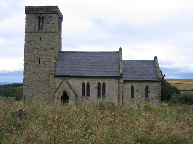
England parish church of St Mary, Wharram-le-Street, Ryedale, East Riding: view from the south
305:
115:
1196:
1079:
1006:
872:
91:
903:
110:
507:
996:
666:
636:
233:
1280:
1186:
1150:
1013:
274:
78:
1290:
1042:
1214:
157:
217:
178:
168:
1023:
254:
898:
266:
829:
Click on a date/time to view the file as it appeared at that time.
219:
936:
212:
54° 04′ 54.48″ N, 0° 40′ 56.64″ W
956:
946:
926:
202:
66:
714:
393:
Add a one-line explanation of what this file represents
971:
894:
Grade I listed buildings in North
Yorkshire (district)
966:
196:
Creative
Commons Attribution Share-alike license 2.0
132:
104:
90:
Commons is a freely licensed media file repository.
581:
Creative
Commons Attribution-ShareAlike 2.0 Generic
56:(640 × 480 pixels, file size: 246 KB, MIME type:
1201:Flash did not fire, compulsory flash suppression
362:https://creativecommons.org/licenses/by-sa/2.0
71:
368:Creative Commons Attribution-Share Alike 2.0
286:
8:
328:– to copy, distribute and transmit the work
989:
831:
389:
919:The following other wikis use this file:
508:https://www.geograph.org.uk/profile/2182
1299:
1288:
1278:
1270:
1262:
1254:
1246:
1238:
1230:
1222:
1212:
1204:
1194:
1184:
1176:
1166:
1158:
1148:
1140:
1119:
1111:
1100:
1092:
1084:
1074:
1066:
1058:
1050:
1039:
1031:
1021:
1011:
1001:
891:
805:
789:
769:
753:
735:
719:
701:
685:
667:https://www.geograph.org.uk/photo/51366
614:
598:
578:
562:
542:
526:
459:
443:
423:
407:
404:
385:
378:
205:
138:Wharram le Street church, Yorkshire.jpg
52:Wharram_le_Street_church,_Yorkshire.jpg
226:View this and other nearby images on:
991:
7:
273:and is licensed for reuse under the
820:
309:Attribution-Share Alike 2.0 Generic
297:
292:
277:Attribution-ShareAlike 2.0 license.
982:
398:
392:
283:
260:
142:
108:
103:
49:
397:
1033:Date and time of data generation
722:coordinates of the point of view
383:
339:Under the following conditions:
304:This file is licensed under the
296:
291:
285:
253:
232:
218:
70:
31:
21:
380:
143:
46:No higher resolution available.
14:
617:file available on the internet
379:
261:This image was taken from the
26:
1:
909:User:Ryanmhorne/pleiades List
36:
652:Geograph Britain and Ireland
473:object of statement has role
405:Items portrayed in this file
1240:Focal plane resolution unit
1113:Date and time of digitizing
933:Usage on lld.wikipedia.org
1321:
1251:One-chip color area sensor
1206:Supported Flashpix version
963:Usage on www.wikidata.org
953:Usage on sv.wikipedia.org
943:Usage on pl.wikipedia.org
923:Usage on fr.wikipedia.org
353:same or compatible license
1121:Meaning of each component
1086:File change date and time
821:
16:
1232:Focal plane Y resolution
1224:Focal plane X resolution
737:54°4'54.5"N, 0°40'56.6"W
630:geograph.org.uk image ID
382:
319:
77:This is a file from the
1264:Custom image processing
1089:23:05, 9 September 2005
878:
184:
174:
163:
156:
153:
135:
81:. Information from its
1142:Image compression mode
267:this photograph's page
238:54.081800; -0.682400
84:description page there
1181:3.34375 APEX (f/3.19)
1178:Maximum land aperture
1060:Horizontal resolution
1259:Digital still camera
857:12:48, 3 August 2008
792:location of creation
426:Church of Saint Mary
1116:13:34, 25 July 2005
1094:Y and C positioning
1080:Adobe Photoshop 7.0
1068:Vertical resolution
1036:13:34, 25 July 2005
1018:1/1,000 sec (0.001)
1007:Canon PowerShot S50
993:Camera manufacturer
772:Canon PowerShot S50
334:– to adapt the work
109:This is a photo of
1301:Scene capture type
1285:Auto white balance
488:author name string
1308:
1307:
957:Wharram le Street
947:Wharram-le-Street
937:Wharram-le-Street
927:Wharram-le-Street
915:Global file usage
904:Wharram-le-Street
882:
565:copyright license
391:
282:
281:
265:collection. See
243:
242:
200:
199:
193:
190:Reusing this file
125:
124:
99:
98:
79:Wikimedia Commons
32:Global file usage
1312:
1235:5,660.3773584906
1227:5,653.7102473498
990:
869:
669:
664:
660:described at URL
654:
649:
639:
634:
529:copyright status
510:
505:
495:
492:
482:
477:
375:
372:
369:
366:
363:
355:as the original.
317:
306:Creative Commons
300:
299:
295:
294:
289:
288:
275:Creative Commons
263:Geograph project
257:
250:
239:
236:
222:
221:
215:
214:
203:
187:
159:
147:
139:
133:
118:
105:
95:
74:
73:
67:
61:
59:
1320:
1319:
1315:
1314:
1313:
1311:
1310:
1309:
978:
913:
890:
883:
875:
867:
823:
822:
819:
818:
817:
816:
815:
814:
813:
812:
810:
798:
797:
796:
794:
783:
782:
781:
780:
779:
778:
777:
776:
774:
762:
761:
760:
758:
747:
746:
745:
744:
743:
742:
741:
740:
738:
728:
727:
726:
724:
713:
712:
711:
710:
709:
708:
707:
706:
704:
694:
693:
692:
690:
679:
678:
677:
676:
675:
674:
673:
672:
671:
670:
665:
662:
656:
655:
650:
647:
641:
640:
635:
632:
623:
622:
621:
619:
607:
606:
605:
603:
592:
591:
590:
589:
588:
587:
586:
585:
583:
571:
570:
569:
567:
556:
555:
554:
553:
552:
551:
550:
549:
547:
535:
534:
533:
531:
520:
519:
518:
517:
516:
515:
514:
513:
512:
511:
506:
503:
497:
496:
493:
490:
484:
483:
478:
475:
466:
465:
464:
462:
452:
451:
450:
448:
437:
436:
435:
434:
433:
432:
431:
430:
428:
416:
415:
414:
412:
396:
395:
394:
377:
376:
373:
370:
367:
364:
361:
360:
318:
315:
312:
301:
278:
248:
237:
210:
209:
206:Camera location
201:
169:geograph.org.uk
149:
137:
130:
120:
114:
111:listed building
101:
100:
89:
88:
87:is shown below.
63:
57:
55:
48:
47:
12:
11:
5:
1318:
1316:
1306:
1305:
1302:
1298:
1297:
1294:
1287:
1286:
1283:
1277:
1276:
1273:
1269:
1268:
1267:Normal process
1265:
1261:
1260:
1257:
1253:
1252:
1249:
1248:Sensing method
1245:
1244:
1241:
1237:
1236:
1233:
1229:
1228:
1225:
1221:
1220:
1217:
1211:
1210:
1207:
1203:
1202:
1199:
1193:
1192:
1189:
1183:
1182:
1179:
1175:
1174:
1171:
1165:
1164:
1161:
1157:
1156:
1153:
1147:
1146:
1143:
1139:
1138:
1137:
1136:
1135:does not exist
1133:
1130:
1127:
1122:
1118:
1117:
1114:
1110:
1109:
1106:
1099:
1098:
1095:
1091:
1090:
1087:
1083:
1082:
1077:
1073:
1072:
1069:
1065:
1064:
1061:
1057:
1056:
1053:
1049:
1048:
1045:
1038:
1037:
1034:
1030:
1029:
1026:
1020:
1019:
1016:
1010:
1009:
1004:
1000:
999:
994:
981:
977:
976:
975:
974:
969:
961:
960:
959:
951:
950:
949:
941:
940:
939:
931:
930:
929:
917:
916:
912:
911:
906:
901:
896:
888:
887:
886:
881:
880:
877:
873:
870:
864:
859:
854:
850:
849:
846:
843:
840:
837:
834:
827:
826:
811:
806:
804:
803:
802:
801:
800:
799:
795:
790:
788:
787:
786:
785:
784:
775:
770:
768:
767:
766:
765:
764:
763:
759:
754:
752:
751:
750:
749:
748:
739:
736:
734:
733:
732:
731:
730:
729:
725:
720:
718:
717:
716:
715:
705:
702:
700:
699:
698:
697:
696:
695:
691:
686:
684:
683:
682:
681:
680:
658:
657:
643:
642:
628:
627:
626:
625:
624:
620:
615:
613:
612:
611:
610:
609:
608:
604:
601:source of file
599:
597:
596:
595:
594:
593:
584:
579:
577:
576:
575:
574:
573:
572:
568:
563:
561:
560:
559:
558:
557:
548:
543:
541:
540:
539:
538:
537:
536:
532:
527:
525:
524:
523:
522:
521:
499:
498:
486:
485:
471:
470:
469:
468:
467:
463:
460:
458:
457:
456:
455:
454:
453:
449:
444:
442:
441:
440:
439:
438:
429:
424:
422:
421:
420:
419:
418:
417:
413:
408:
406:
403:
402:
401:
400:
399:
388:
387:
384:
381:
359:
358:
357:
356:
346:
337:
336:
335:
329:
322:You are free:
313:
303:
302:
284:
280:
279:
258:
247:
244:
241:
240:
230:
224:
207:
198:
197:
194:
182:
181:
176:
172:
171:
165:
161:
160:
155:
151:
150:
140:
131:
129:
126:
123:
122:
102:
97:
96:
75:
65:
64:
45:
41:
40:
39:
34:
29:
24:
19:
13:
10:
9:
6:
4:
3:
2:
1317:
1303:
1300:
1295:
1292:
1289:
1284:
1282:
1281:White balance
1279:
1275:Auto exposure
1274:
1272:Exposure mode
1271:
1266:
1263:
1258:
1255:
1250:
1247:
1242:
1239:
1234:
1231:
1226:
1223:
1218:
1216:
1213:
1208:
1205:
1200:
1198:
1195:
1190:
1188:
1187:Metering mode
1185:
1180:
1177:
1172:
1170:
1169:Exposure bias
1167:
1162:
1160:APEX aperture
1159:
1154:
1152:
1151:Shutter speed
1149:
1144:
1141:
1134:
1131:
1128:
1125:
1124:
1123:
1120:
1115:
1112:
1107:
1104:
1101:
1096:
1093:
1088:
1085:
1081:
1078:
1076:Software used
1075:
1070:
1067:
1062:
1059:
1054:
1051:
1046:
1044:
1040:
1035:
1032:
1027:
1025:
1022:
1017:
1015:
1014:Exposure time
1012:
1008:
1005:
1002:
998:
995:
992:
988:
985:
979:
973:
970:
968:
965:
964:
962:
958:
955:
954:
952:
948:
945:
944:
942:
938:
935:
934:
932:
928:
925:
924:
922:
921:
920:
914:
910:
907:
905:
902:
900:
897:
895:
892:
884:
876:
874:Angusmclellan
871:
865:
863:
860:
858:
855:
852:
851:
847:
844:
841:
838:
835:
833:
832:
830:
824:
809:
793:
773:
757:
756:captured with
723:
689:
668:
661:
653:
646:
638:
631:
618:
602:
582:
566:
546:
530:
509:
502:
494:Rodney Burton
489:
481:
474:
447:
427:
411:
365:CC BY-SA 2.0
354:
350:
347:
344:
341:
340:
338:
333:
330:
327:
324:
323:
321:
320:
316:Rodney Burton
314:Attribution:
310:
307:
290:
276:
272:
271:Rodney Burton
268:
264:
259:
256:
252:
251:
245:
235:
231:
229:
228:OpenStreetMap
225:
223:
213:
208:
204:
195:
191:
186:
183:
180:
179:Rodney Burton
177:
173:
170:
166:
162:
152:
146:
141:
134:
127:
121:
117:
112:
107:
106:
93:
86:
85:
80:
76:
69:
68:
62:
53:
44:
38:
35:
33:
30:
28:
25:
23:
20:
18:
15:
1291:Digital zoom
1043:focal length
1003:Camera model
986:
983:
918:
828:
825:File history
703:25 July 2005
480:photographer
348:
342:
331:
325:
270:
158:25 July 2005
144:
92:You can help
82:
50:
22:File history
1256:File source
1215:Color space
1052:Orientation
545:copyrighted
349:share alike
343:attribution
136:Description
885:File usage
866:640 × 480
842:Dimensions
461:some value
185:Permission
58:image/jpeg
27:File usage
972:Q17538327
839:Thumbnail
836:Date/Time
688:inception
246:Licensing
145:English:
1304:Standard
1097:Centered
1047:8.625 mm
1024:F-number
980:Metadata
967:Q7990692
868:(246 KB)
645:operator
386:Captions
332:to remix
326:to share
311:license.
37:Metadata
1191:Pattern
1163:3.34375
1155:9.96875
1105:version
1071:180 dpi
1063:180 dpi
899:Wharram
853:current
848:Comment
808:Ryedale
446:creator
410:depicts
390:English
128:Summary
116:1149064
113:number
54:
1243:inches
1055:Normal
216:
175:Author
164:Source
1293:ratio
1197:Flash
1041:Lens
1028:f/3.2
997:Canon
637:51366
167:From
1219:sRGB
1103:Exif
845:User
374:true
371:true
154:Date
17:File
1108:2.2
501:URL
1132:Cr
1129:Cb
663::
648::
633::
504::
491::
476::
1296:1
1209:1
1173:0
1145:3
1126:Y
192:)
188:(
119:.
94:.
60:)
Text is available under the Creative Commons Attribution-ShareAlike License. Additional terms may apply.
