38:
242:
248:
253:
94:
738:
1211:
966:
300:– You must give appropriate credit, provide a link to the license, and indicate if changes were made. You may do so in any reasonable manner, but not in any way that suggests the licensor endorses you or your use.
981:
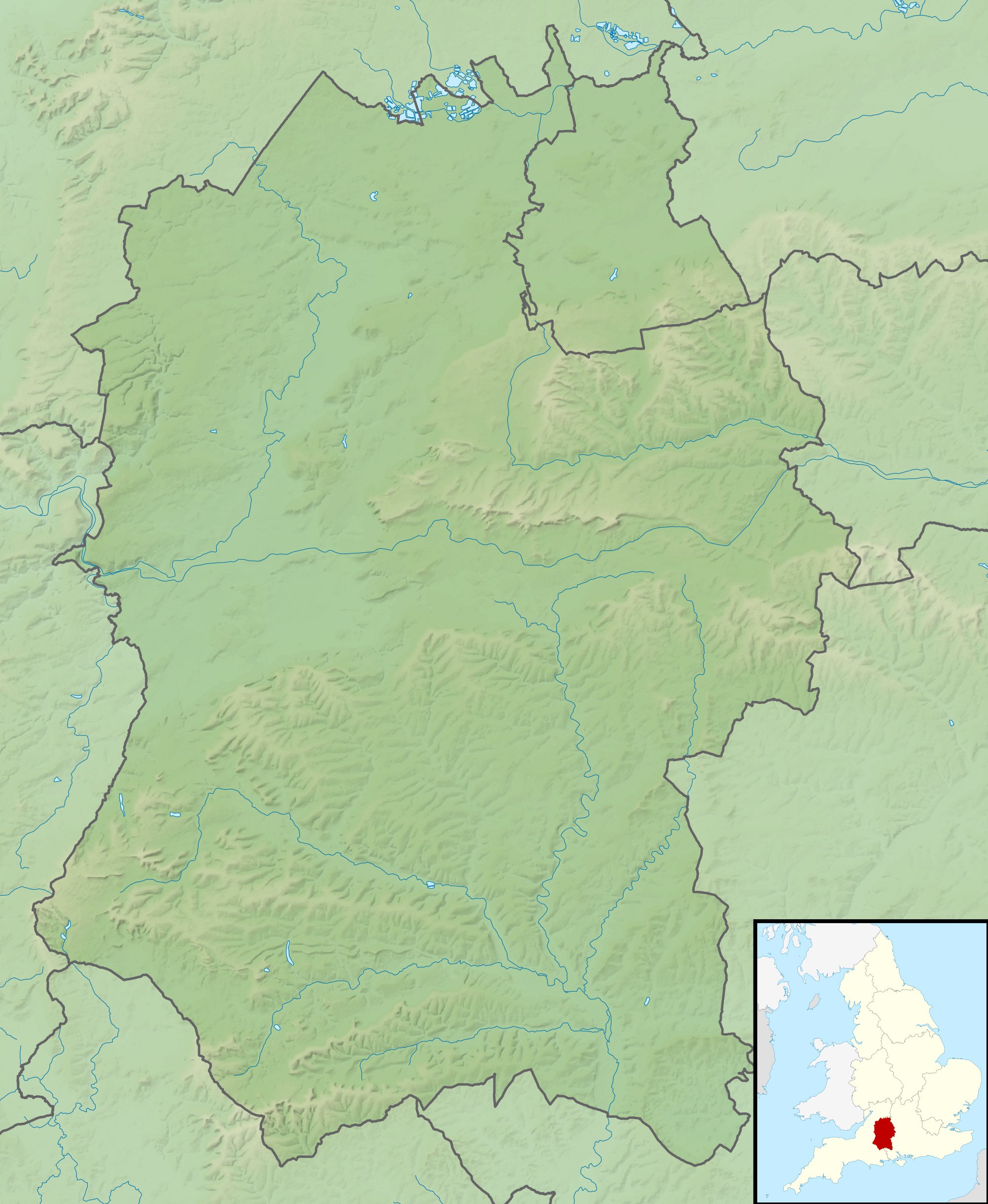
759:, UK. Equirectangular map projection on WGS 84 datum, with N/S stretched 160% Geographic limits: *West: 2.40W *East: 1.35W *North: 51.72N *South: 50.92N |Source=[[w:Ordnance Survey|Ordnan
1280:
913:
1161:
908:
1141:
1171:
60:
56:
52:
48:
42:
105:
73:
1226:
1221:
843:
1131:
340:
231:
918:
1126:
1061:
1186:
682:
449:
413:
991:
307:
648:
614:
577:
540:
503:
397:
803:
783:
675:
469:
433:
380:
788:
202:
263:
863:
793:
1051:
936:
903:
769:
The following pages on the
English Knowledge (XXG) use this file (pages on other projects are not listed):
976:
306:– If you remix, transform, or build upon the material, you must distribute your contributions under the
1046:
737:
732:
64:
37:
868:
833:
260:
883:
1121:
971:
956:
185:
113:
858:
1026:
1001:
946:
773:
182:
1176:
823:
1016:
1206:
1091:
961:
898:
798:
748:
878:
853:
818:
813:
100:
893:
888:
838:
1151:
1056:
951:
219:
206:
171:
139:
1196:
873:
848:
828:
756:
1241:
1011:
1271:
1246:
145:
Equirectangular map projection on WGS 84 datum, with N/S stretched 160%
808:
778:
1251:
195:
Administrative borders and coastline data from
Boundary-Line product.
705:
Click on a date/time to view the file as it appeared at that time.
1086:
1076:
271:
Contains
Ordnance Survey data © Crown copyright and database right
1036:
1236:
1106:
1031:
88:
1096:
1111:
1256:
1101:
1071:
364:
Add a one-line explanation of what this file represents
1227:ਮੌਡਿਊਲ:Location map/data/United Kingdom Wiltshire/doc
914:
Module:Location map/data/United
Kingdom Wiltshire/doc
78:(2,005 × 2,444 pixels, file size: 508 KB, MIME type:
1132:モジュール:Location map/data/United Kingdom Wiltshire/doc
1081:
450:
Creative
Commons Attribution-ShareAlike 3.0 Unported
127:
112:
Commons is a freely licensed media file repository.
1261:
198:All other geographic data from Meridian 2 product.
1222:ਮੌਡਿਊਲ:Location map/data/United Kingdom Wiltshire
909:Module:Location map/data/United Kingdom Wiltshire
1127:モジュール:Location map/data/United Kingdom Wiltshire
1142:ಟೆಂಪ್ಲೇಟು:Location map United Kingdom Wiltshire
1002:Plantilya:Location map United Kingdom Wiltshire
1177:Template:Location map United Kingdom Wiltshire
317:https://creativecommons.org/licenses/by-sa/3.0
93:
323:Creative Commons Attribution-Share Alike 3.0
241:
8:
192:Relief data from Land-Form Panorama product.
1187:ढाँचा:Location map United Kingdom Wiltshire
1027:Plantilla:Mapa de localización de Wiltshire
1017:Nodyn:Location map United Kingdom Wiltshire
283:– to copy, distribute and transmit the work
1052:الگو:Location map United Kingdom Wiltshire
937:قالب:Location map United Kingdom Wiltshire
707:
360:
341:File:Wiltshire UK district map (blank).svg
929:The following other wikis use this file:
755:{{Information |Description=Relief map of
664:b9ef0b776b9a51fe1bfe937a524d7582e18dad86
771:
662:
646:
628:
612:
591:
575:
554:
538:
517:
501:
483:
467:
447:
431:
411:
395:
378:
375:
356:
349:
844:Poisoning of Sergei and Yulia Skripal
7:
1212:Хуызæг:ПозКартæ Стыр Британи Уилтшир
264:Attribution-Share Alike 3.0 Unported
222:, created using Ordnance Survey data
133:Wiltshire UK relief location map.jpg
696:
252:
247:
919:Module:Location map/data/Wiltshire
369:
363:
238:
125:
71:
368:
1092:Modèle:Géolocalisation/Wiltshire
967:Шаблон:ПК Великобритания Уилтшър
354:
294:Under the following conditions:
259:This file is licensed under the
251:
246:
240:
92:
31:
21:
1197:Sjabloon:Positiekaart Wiltshire
351:
14:
350:
26:
1:
1012:Nodyn:Location map Wiltshire
376:Items portrayed in this file
1152:Veidne:VietasKarte Viltšīra
998:Usage on ceb.wikipedia.org
804:Challenge Tour Championship
784:Bath House at Corsham Court
1297:
1268:Usage on pl.wikibooks.org
1233:Usage on pl.wikipedia.org
1218:Usage on pa.wikipedia.org
1203:Usage on os.wikipedia.org
1193:Usage on nl.wikipedia.org
1183:Usage on ne.wikipedia.org
1168:Usage on my.wikipedia.org
1158:Usage on mk.wikipedia.org
1148:Usage on lv.wikipedia.org
1138:Usage on kn.wikipedia.org
1118:Usage on ja.wikipedia.org
1068:Usage on fr.wikipedia.org
1043:Usage on fa.wikipedia.org
1023:Usage on es.wikipedia.org
1008:Usage on cy.wikipedia.org
988:Usage on bh.wikipedia.org
943:Usage on bg.wikipedia.org
933:Usage on ar.wikipedia.org
308:same or compatible license
1242:Moduł:Mapa/dane/Wiltshire
982:Западноуилтшърски хълмове
789:Battle of Aldbourne Chase
697:
16:
1087:Bataille d'Edington
1077:Bataille d'Ellendun
353:
274:
203:England location map.svg
99:This is a file from the
1162:Шаблон:ПолКарта Вилтшир
864:Siege of Wardour Castle
794:Battle of Roundway Down
754:
733:02:03, 29 November 2011
336:
226:
215:
177:
170:
167:
130:
103:. Information from its
1272:Moduł:Mapa/dane/GB-WIL
1247:Moduł:Mapa/dane/GB-WIL
904:Windmill Hill, Avebury
106:description page there
41:Size of this preview:
884:Vespasian's Camp
869:Stonehenge Landscape
834:Moat House, Britford
676:determination method
65:2,005 × 2,444 pixels
1252:Ray (dopływ Tamizy)
289:– to adapt the work
201:Inset derived from
148:Geographic limits:
47:Other resolutions:
1237:Bitwa pod Ellandun
1107:Bataille de Wilton
61:840 × 1,024 pixels
1281:more global usage
925:Global file usage
859:Shearwater (lake)
762:
434:copyright license
362:
347:
346:
235:
232:Reusing this file
121:
120:
101:Wikimedia Commons
32:Global file usage
1288:
1097:Abbaye de Wilton
774:Alvediston Manor
745:
685:
680:
596:
559:
522:
485:29 November 2010
398:copyright status
330:
327:
324:
321:
318:
310:as the original.
272:
261:Creative Commons
255:
254:
250:
249:
244:
243:
229:
173:
172:29 November 2010
134:
128:
117:
96:
95:
89:
83:
81:
68:
57:630 × 768 pixels
53:394 × 480 pixels
49:197 × 240 pixels
43:492 × 600 pixels
1296:
1295:
1291:
1290:
1289:
1287:
1286:
1285:
1062:محوطه استونهنج
923:
824:Martinsell Hill
770:
763:
751:
743:
699:
698:
695:
694:
693:
692:
691:
690:
689:
688:
687:
686:
681:
678:
669:
668:
667:
665:
655:
654:
653:
651:
640:
639:
638:
637:
636:
635:
634:
633:
631:
621:
620:
619:
617:
606:
605:
604:
603:
602:
601:
600:
599:
597:
594:
584:
583:
582:
580:
569:
568:
567:
566:
565:
564:
563:
562:
560:
557:
547:
546:
545:
543:
532:
531:
530:
529:
528:
527:
526:
525:
523:
520:
510:
509:
508:
506:
495:
494:
493:
492:
491:
490:
489:
488:
486:
476:
475:
474:
472:
461:
460:
459:
458:
457:
456:
455:
454:
452:
440:
439:
438:
436:
425:
424:
423:
422:
421:
420:
419:
418:
416:
404:
403:
402:
400:
389:
388:
387:
386:
385:
383:
367:
366:
365:
348:
332:
331:
328:
325:
322:
319:
316:
315:
273:
270:
267:
256:
183:Ordnance Survey
132:
123:
122:
111:
110:
109:is shown below.
85:
79:
77:
70:
69:
46:
12:
11:
5:
1294:
1292:
1283:of this file.
1277:
1276:
1275:
1274:
1266:
1265:
1264:
1259:
1254:
1249:
1244:
1239:
1231:
1230:
1229:
1224:
1216:
1215:
1214:
1209:
1201:
1200:
1199:
1191:
1190:
1189:
1181:
1180:
1179:
1174:
1166:
1165:
1164:
1156:
1155:
1154:
1146:
1145:
1144:
1136:
1135:
1134:
1129:
1124:
1116:
1115:
1114:
1112:Barbury Castle
1109:
1104:
1099:
1094:
1089:
1084:
1079:
1074:
1066:
1065:
1064:
1059:
1054:
1049:
1041:
1040:
1039:
1037:Túnel de Bruce
1034:
1029:
1021:
1020:
1019:
1014:
1006:
1005:
1004:
996:
995:
994:
986:
985:
984:
979:
974:
969:
964:
959:
954:
949:
941:
940:
939:
927:
926:
922:
921:
916:
911:
906:
901:
899:Win Green Down
896:
891:
886:
881:
876:
871:
866:
861:
856:
851:
846:
841:
836:
831:
826:
821:
816:
811:
806:
801:
799:Bluestonehenge
796:
791:
786:
781:
776:
768:
767:
766:
761:
760:
753:
749:
746:
742:2,005 × 2,444
740:
735:
730:
726:
725:
722:
719:
716:
713:
710:
703:
702:
674:
673:
672:
671:
670:
666:
663:
661:
660:
659:
658:
657:
656:
652:
647:
645:
644:
643:
642:
641:
632:
629:
627:
626:
625:
624:
623:
622:
618:
613:
611:
610:
609:
608:
607:
598:
592:
590:
589:
588:
587:
586:
585:
581:
576:
574:
573:
572:
571:
570:
561:
555:
553:
552:
551:
550:
549:
548:
544:
539:
537:
536:
535:
534:
533:
524:
518:
516:
515:
514:
513:
512:
511:
507:
502:
500:
499:
498:
497:
496:
487:
484:
482:
481:
480:
479:
478:
477:
473:
468:
466:
465:
464:
463:
462:
453:
448:
446:
445:
444:
443:
442:
441:
437:
432:
430:
429:
428:
427:
426:
417:
412:
410:
409:
408:
407:
406:
405:
401:
396:
394:
393:
392:
391:
390:
384:
379:
377:
374:
373:
372:
371:
370:
359:
358:
355:
352:
345:
344:
338:
337:Other versions
334:
333:
314:
313:
312:
311:
301:
292:
291:
290:
284:
277:You are free:
268:
258:
257:
239:
236:
224:
223:
217:
213:
212:
211:
210:
199:
196:
193:
179:
175:
174:
169:
165:
164:
163:
162:
159:
156:
153:
138:Relief map of
135:
126:
124:
119:
118:
97:
87:
86:
40:
36:
35:
34:
29:
24:
19:
13:
10:
9:
6:
4:
3:
2:
1293:
1284:
1282:
1273:
1270:
1269:
1267:
1263:
1260:
1258:
1257:Wylye (rzeka)
1255:
1253:
1250:
1248:
1245:
1243:
1240:
1238:
1235:
1234:
1232:
1228:
1225:
1223:
1220:
1219:
1217:
1213:
1210:
1208:
1205:
1204:
1202:
1198:
1195:
1194:
1192:
1188:
1185:
1184:
1182:
1178:
1175:
1173:
1172:စတုန်းဟင်းချ်
1170:
1169:
1167:
1163:
1160:
1159:
1157:
1153:
1150:
1149:
1147:
1143:
1140:
1139:
1137:
1133:
1130:
1128:
1125:
1123:
1120:
1119:
1117:
1113:
1110:
1108:
1105:
1103:
1100:
1098:
1095:
1093:
1090:
1088:
1085:
1083:
1080:
1078:
1075:
1073:
1070:
1069:
1067:
1063:
1060:
1058:
1055:
1053:
1050:
1048:
1045:
1044:
1042:
1038:
1035:
1033:
1030:
1028:
1025:
1024:
1022:
1018:
1015:
1013:
1010:
1009:
1007:
1003:
1000:
999:
997:
993:
990:
989:
987:
983:
980:
978:
975:
973:
970:
968:
965:
963:
960:
958:
955:
953:
950:
948:
945:
944:
942:
938:
935:
934:
932:
931:
930:
924:
920:
917:
915:
912:
910:
907:
905:
902:
900:
897:
895:
892:
890:
887:
885:
882:
880:
879:The Sanctuary
877:
875:
872:
870:
867:
865:
862:
860:
857:
855:
854:Roundway Park
852:
850:
847:
845:
842:
840:
837:
835:
832:
830:
827:
825:
822:
820:
819:Kennet Avenue
817:
815:
814:Fonthill Lake
812:
810:
807:
805:
802:
800:
797:
795:
792:
790:
787:
785:
782:
780:
777:
775:
772:
764:
758:
752:
747:
741:
739:
736:
734:
731:
728:
727:
723:
720:
717:
714:
711:
709:
708:
706:
700:
684:
677:
650:
616:
579:
542:
505:
471:
451:
435:
415:
399:
382:
342:
339:
335:
320:CC BY-SA 3.0
309:
305:
302:
299:
296:
295:
293:
288:
285:
282:
279:
278:
276:
275:
269:Attribution:
265:
262:
245:
237:
233:
228:
225:
221:
218:
214:
208:
204:
200:
197:
194:
191:
190:
189:
187:
184:
180:
176:
166:
161:South: 50.92N
160:
158:North: 51.72N
157:
154:
151:
150:
149:
146:
143:
141:
136:
129:
115:
108:
107:
102:
98:
91:
90:
84:
75:
74:Original file
66:
62:
58:
54:
50:
44:
39:
33:
30:
28:
25:
23:
20:
18:
15:
1278:
1102:Sidbury Hill
1032:Túnel de Box
928:
894:Wilton Water
889:White Barrow
839:Overton Hill
704:
701:File history
303:
297:
286:
280:
181:
147:
144:
137:
114:You can help
104:
72:
22:File history
414:copyrighted
343:- Blank map
304:share alike
298:attribution
155:East: 1.35W
152:West: 2.40W
131:Description
1072:Stonehenge
977:Килмингтън
765:File usage
718:Dimensions
630:image/jpeg
615:media type
227:Permission
80:image/jpeg
27:File usage
1047:استونهنج
992:स्टोनहेंज
972:Троубридж
957:Лъкингтън
874:Stourhead
849:River Sem
829:Milk Hill
757:Wiltshire
750:Nilfanion
715:Thumbnail
712:Date/Time
504:data size
470:inception
220:Nilfanion
140:Wiltshire
947:Солсбъри
744:(508 KB)
649:checksum
519:520,536
357:Captions
287:to remix
281:to share
266:license.
207:Spischot
186:OpenData
1207:Уилтшир
1082:Avebury
962:Суиндън
809:Cunetio
779:Avebury
729:current
724:Comment
381:depicts
361:English
76:
1262:Nadder
1122:エーヴベリー
1057:ایوبری
952:Уилтън
593:2,005
556:2,444
541:height
216:Author
178:Source
142:, UK.
1279:View
683:SHA-1
595:pixel
578:width
558:pixel
721:User
521:byte
329:true
326:true
168:Date
17:File
205:by
679::
188:.
63:|
59:|
55:|
51:|
45:.
234:)
230:(
209:.
116:.
82:)
67:.
Text is available under the Creative Commons Attribution-ShareAlike License. Additional terms may apply.
.svg)