43:
581:
154:
168:
587:
518:
681:
592:
546:
99:
912:
407:
1166:
646:– You must give appropriate credit, provide a link to the license, and indicate if changes were made. You may do so in any reasonable manner, but not in any way that suggests the licensor endorses you or your use.
145:
1478:
1176:
73:
69:
1171:
65:
61:
57:
53:
47:
533:
110:
82:
1224:
929:== {{int:filedesc}} == {{Location|37|00|00|N|140|00|00|E|scale:10000}} {{Information |Description= {{fr|Carte topographique vierge de la
466:
1021:
614:
504:
789:
753:
161:
1489:
This file contains additional information, probably added from the digital camera or scanner used to create or digitize it.
653:
610:
1121:
488:) as the author and distribute the copies and derivative works under the same license(s) that the one(s) stated below. A
1151:
843:
737:
1289:
1299:
809:
773:
720:
996:
602:
529:
489:
1086:
1001:
1076:
1011:
986:
911:
906:
525:
42:
1492:
If the file has been modified from its original state, some details may not fully reflect the modified file.
1046:
991:
1294:
1194:
956:
1429:
1141:
1126:
1116:
1096:
1026:
981:
930:
652:– If you remix, transform, or build upon the material, you must distribute your contributions under the
196:
395:
1051:
599:
455:
224:
1111:
248:
236:
1449:
1131:
966:
118:
1264:
212:
1156:
1146:
1101:
1066:
1041:
1036:
951:
1214:
449:
1071:
1006:
1136:
1061:
1031:
922:
1081:
976:
555:
259:
167:
517:
347:
314: : équirectangulaire + vertical stretching +40% ; système géodésique WGS84
105:
574:
I, the copyright holder of this work, hereby publish it under the following license:
282:
des données topographiques pour les srtm3: 1:372 000 (précision : 93 m) ;
1091:
445:
383:
1106:
1056:
1016:
961:
1444:
426:
1161:
559:
378: : données de la carte © les contributeurs d'OpenStreetMap, CC-BY-SA
971:
1279:
271:
1414:
1454:
1167:
User:Ty654/List of earthquakes from 1940-1949 exceeding magnitude 6+
151:
934:
879:
Click on a date/time to view the file as it appeared at that time.
200:
1249:
1204:
1439:
1389:
1234:
485:
836:
545:
367:
153:
1349:
379:
1369:
1239:
136:
93:
1399:
1394:
1244:
937:, destinée à la géolocalisation.}} {{de|Topographische Ka...
286:
of topographic data: 1:372,000 (accuracy : about 93 m);
87:(SVG file, nominally 1,719 × 2,384 pixels, file size: 2.1 MB)
1364:
1324:
1269:
1259:
1254:
679:
484:
Any use of this image can be made as long as you credit me (
1469:
1434:
1424:
1379:
146:
37° 00′ 00″ N, 140° 00′ 00″ E
1384:
1334:
663:
https://creativecommons.org/licenses/by-sa/2.0/fr/deed.en
1359:
492:
with a reply address would also be greatly appreciated.
376:
Lakes, river, boundaries / Lacs, cours d'eau, frontières
1459:
1419:
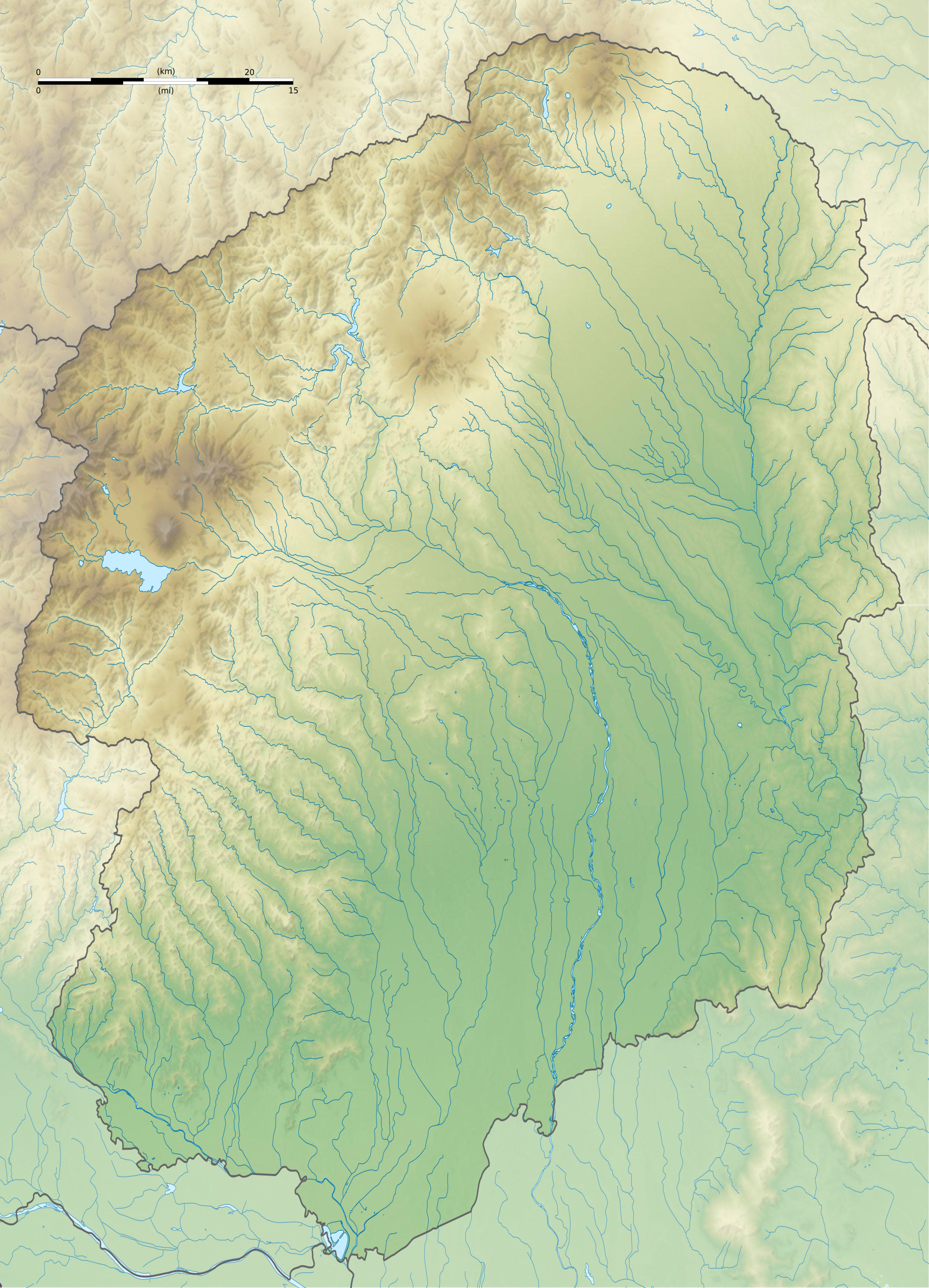
1319:
1309:
704:
Add a one-line explanation of what this file represents
419:
413:
1464:
1274:
1177:
Module:Location map/data/Japan
Tochigi Prefecture/doc
1374:
1354:
179:
117:
Commons is a freely licensed media file repository.
1404:
1314:
536:to clean up, improve, create or translate as well.
1344:
1339:
790:Creative Commons Attribution-ShareAlike 2.0 France
1409:
1329:
1172:Module:Location map/data/Japan Tochigi Prefecture
1215:Plantilya:Location map Japan Tochigi Prefecture
669:Creative Commons Attribution-Share Alike 2.0 fr
1265:Vorlage:Positionskarte Japan Präfektur Tochigi
98:
580:
8:
1430:Modèle:Géolocalisation/Préfecture de Tochigi
1290:پودمان:Location map Japan Tochigi Prefecture
336:is a raster image embedded in the SVG file.
324: : image of N-W lightning position. Le
629:– to copy, distribute and transmit the work
46:Size of this PNG preview of this SVG file:
1494:
1450:Portail:Préfecture de Tochigi/Présentation
1295:الگو:Location map Japan Tochigi Prefecture
1195:قالب:Location map Japan Tochigi Prefecture
881:
700:
512:
473:
1187:The following other wikis use this file:
524:This map was improved or created by the
1512:
1504:
1496:
949:
857:
841:
823:
807:
787:
771:
751:
735:
718:
715:
696:
689:
482:
139:
947:The following 46 pages use this file:
185:Tochigi-ken géolocalisation relief.svg
160:View this and other nearby images on:
368:NASA Shuttle Radar Topography Mission
332:embarquée dans le fichier SVG. / The
270:Carta topográfica de la província de
7:
505:File:Tochigi-ken géolocalisation.svg
478:Attribution and Share-Alike required
870:
591:
586:
370:(SRTM3 v.2) (domaine public) ;
1487:
709:
703:
603:Attribution-Share Alike 2.0 France
577:
573:
550:
523:
486:Wikimedia Commons user: Bourrichon
265:
264:
253:
241:
229:
217:
205:
189:
130:
80:
708:
195:Carte topographique vierge de la
844:coordinates of the point of view
694:
640:Under the following conditions:
598:This file is licensed under the
590:
585:
579:
544:
516:
254:
203:, destinée à la géolocalisation.
166:
152:
97:
31:
21:
691:
392:Other symbols / autres symboles
242:
230:
218:
14:
1022:Kamikōnushi-Mobara Kanga ruins
690:
227:, for geolocalisation purpose.
206:
190:
26:
1:
1445:Portail:Préfecture de Tochigi
1122:Shimotsuke Provincial Capital
404:Software / logiciels utilisés
294:Approximate geographic limits
223:Topographic blank map of the
36:
1152:Utsunomiya Futarayama Shrine
716:Items portrayed in this file
475:
359:Création personnelle ;
322:Shaded relief / relief ombré
1415:Mine de cuivre d'Ashio
1211:Usage on ceb.wikipedia.org
859:37°0'0.000"N, 140°0'0.000"E
1534:
1306:Usage on fr.wikipedia.org
1286:Usage on fa.wikipedia.org
1231:Usage on de.wikipedia.org
1221:Usage on ce.wikipedia.org
1201:Usage on ca.wikipedia.org
1191:Usage on ar.wikipedia.org
654:same or compatible license
429:pour le relief de la NASA.
1002:Fujimoto Kannonyama Kofun
871:
396:File:Maps template-fr.svg
211:Topographische Karte der
16:
1077:Nasu Ogawa Kofun Cluster
1012:Gene Sarazen Jun Classic
997:Chōjagadaira Kanga ruins
931:fr:Préfecture de Tochigi
693:
620:
247:Mappa topografica della
104:This is a file from the
1097:Sakuramachi Jin'ya
1087:Otomefudōhara Tile Kiln
1047:Kurumazuka Kofun (Mibu)
992:Chausuyama Kofun (Mibu)
928:
515:
500:
461:
440:
354:
346:
343:
235:Mapa topográfico de la
182:
108:. Information from its
1280:Oku-Nikkō-Feuchtgebiet
957:Atagozuka Kofun (Mibu)
684:
172:37.000000; 140.000000
111:description page there
1205:Prefectura de Tochigi
1142:Ushizuka Kofun (Mibu)
1127:Shimotsuke Yakushi-ji
1117:Shimotsuke Kokubun-ji
1027:Karanogosho Cave Tomb
987:Cedar Avenue of Nikkō
982:Brex Arena Utsunomiya
683:
280:Échelle approximative
249:Prefettura di Tochigi
237:Prefectura de Tochigi
197:Préfecture de Tochigi
1440:Takanezawa (Tochigi)
1390:Shimotsuke (Tochigi)
1235:Ontake-san (Tochigi)
1052:Marishitenzuka Kofun
74:1,719 × 2,384 pixels
70:1,477 × 2,048 pixels
1225:Тотиги (префектура)
1112:Sanuki Stone Buddha
635:– to adapt the work
532:(fr). You can
408:dans ce didacticiel
52:Other resolutions:
1455:Mont Nikkō-Shirane
1350:Ashikaga (Tochigi)
1132:Teranohigashi Site
967:Babul Islam Mosque
907:18:08, 8 July 2013
685:
565:
348:3 July 2013, 18:49
304:* O : 139.31
302:* E : 140.32
225:Tochigi Prefecture
66:738 × 1,024 pixels
1521:
1520:
1501:Generated with Qt
1479:more global usage
1183:Global file usage
1147:Utsunomiya Castle
1102:Samuraizuka Kofun
1067:Nasu Kanda Castle
1042:Kogane Ichirizuka
1037:Karasuyama Castle
940:
774:copyright license
702:
615:atelier graphique
558:was created with
542:
541:
540:
510:
509:
496:
495:
470:
467:Reusing this file
436:
432:
406:(méthode décrite
337:
315:
305:
298:* N : 37.18
296:of the map :
287:
284:Approximate scale
213:Präfektur Tochigi
177:
176:
126:
125:
106:Wikimedia Commons
32:Global file usage
1525:
1495:
1400:Twin Ring Motegi
1395:Sakura (Tochigi)
1072:Nasu Kanga ruins
1007:Futarasan shrine
919:
738:copyright status
682:
676:
673:
670:
667:
664:
656:as the original.
618:
600:Creative Commons
594:
593:
589:
588:
583:
582:
548:
520:
513:
474:
464:
452:
435:
402:
349:
320:
310:
300:* S : 36.18
292:
278:
269:
258:
246:
234:
222:
210:
194:
192:Français :
186:
180:
173:
170:
156:
155:
149:
148:
137:
122:
101:
100:
94:
88:
77:
62:554 × 768 pixels
58:346 × 480 pixels
54:173 × 240 pixels
48:432 × 599 pixels
1533:
1532:
1528:
1527:
1526:
1524:
1523:
1522:
1483:
1365:Chutes de Kegon
1325:Oyama (Tochigi)
1270:Burg Karasuyama
1260:Burg Utsunomiya
1255:Nantai (Vulkan)
1181:
1137:Tobiyama Castle
1062:Mibu Ichirizuka
1032:Karasawa Castle
941:
925:
917:
873:
872:
869:
868:
867:
866:
865:
864:
863:
862:
860:
850:
849:
848:
846:
835:
834:
833:
832:
831:
830:
829:
828:
826:
816:
815:
814:
812:
801:
800:
799:
798:
797:
796:
795:
794:
792:
780:
779:
778:
776:
765:
764:
763:
762:
761:
760:
759:
758:
756:
744:
743:
742:
740:
729:
728:
727:
726:
725:
723:
707:
706:
705:
688:
687:
686:
680:
677:
674:
671:
668:
666:CC BY-SA 2.0 fr
665:
662:
661:
619:
609:
606:
595:
576:
575:
570:
564:
563:
553:W3C-unspecified
537:
511:
450:
275:
263:
252:
240:
228:
216:
204:
184:
171:
144:
143:
140:Camera location
135:
128:
127:
116:
115:
114:is shown below.
90:
86:
79:
78:
51:
12:
11:
5:
1531:
1529:
1519:
1518:
1515:
1511:
1510:
1507:
1503:
1502:
1499:
1486:
1481:of this file.
1475:
1474:
1473:
1472:
1470:Haga (Tochigi)
1467:
1462:
1457:
1452:
1447:
1442:
1437:
1435:Nogi (Tochigi)
1432:
1427:
1425:Nasu (Tochigi)
1422:
1417:
1412:
1407:
1402:
1397:
1392:
1387:
1382:
1380:Nasukarasuyama
1377:
1372:
1367:
1362:
1357:
1352:
1347:
1342:
1337:
1332:
1327:
1322:
1317:
1312:
1304:
1303:
1302:
1297:
1292:
1284:
1283:
1282:
1277:
1272:
1267:
1262:
1257:
1252:
1247:
1242:
1237:
1229:
1228:
1227:
1219:
1218:
1217:
1209:
1208:
1207:
1199:
1198:
1197:
1185:
1184:
1180:
1179:
1174:
1169:
1164:
1159:
1157:Ōtawara Castle
1154:
1149:
1144:
1139:
1134:
1129:
1124:
1119:
1114:
1109:
1104:
1099:
1094:
1089:
1084:
1082:Negoyadai Site
1079:
1074:
1069:
1064:
1059:
1054:
1049:
1044:
1039:
1034:
1029:
1024:
1019:
1014:
1009:
1004:
999:
994:
989:
984:
979:
977:Biwazuka Kofun
974:
969:
964:
959:
954:
952:Ashikaga Gakkō
945:
944:
939:
938:
927:
923:
920:
916:1,719 × 2,384
914:
909:
904:
900:
899:
896:
893:
890:
887:
884:
877:
876:
861:
858:
856:
855:
854:
853:
852:
851:
847:
842:
840:
839:
838:
837:
827:
824:
822:
821:
820:
819:
818:
817:
813:
808:
806:
805:
804:
803:
802:
793:
788:
786:
785:
784:
783:
782:
781:
777:
772:
770:
769:
768:
767:
766:
757:
752:
750:
749:
748:
747:
746:
745:
741:
736:
734:
733:
732:
731:
730:
724:
719:
717:
714:
713:
712:
711:
710:
699:
698:
695:
692:
678:
660:
659:
658:
657:
647:
638:
637:
636:
630:
623:You are free:
607:
597:
596:
578:
572:
571:
569:
566:
543:
539:
538:
534:propose images
521:
508:
507:
502:
501:Other versions
498:
497:
494:
493:
481:
480:
471:
459:
458:
442:
438:
437:
434:
433:
431:
430:
423:
417:
399:
398:
388:
387:
372:
371:
356:
352:
351:
345:
341:
340:
339:
338:
328:est une image
317:
316:
307:
306:
289:
288:
187:
178:
175:
174:
164:
158:
141:
134:
131:
129:
124:
123:
102:
92:
91:
45:
41:
40:
39:
34:
29:
24:
19:
13:
10:
9:
6:
4:
3:
2:
1530:
1516:
1513:
1508:
1505:
1500:
1497:
1493:
1490:
1484:
1482:
1480:
1471:
1468:
1466:
1463:
1461:
1458:
1456:
1453:
1451:
1448:
1446:
1443:
1441:
1438:
1436:
1433:
1431:
1428:
1426:
1423:
1421:
1418:
1416:
1413:
1411:
1408:
1406:
1403:
1401:
1398:
1396:
1393:
1391:
1388:
1386:
1383:
1381:
1378:
1376:
1373:
1371:
1368:
1366:
1363:
1361:
1358:
1356:
1353:
1351:
1348:
1346:
1343:
1341:
1338:
1336:
1333:
1331:
1328:
1326:
1323:
1321:
1318:
1316:
1313:
1311:
1308:
1307:
1305:
1301:
1300:قلعه کاراساوا
1298:
1296:
1293:
1291:
1288:
1287:
1285:
1281:
1278:
1276:
1273:
1271:
1268:
1266:
1263:
1261:
1258:
1256:
1253:
1251:
1248:
1246:
1243:
1241:
1238:
1236:
1233:
1232:
1230:
1226:
1223:
1222:
1220:
1216:
1213:
1212:
1210:
1206:
1203:
1202:
1200:
1196:
1193:
1192:
1190:
1189:
1188:
1182:
1178:
1175:
1173:
1170:
1168:
1165:
1163:
1160:
1158:
1155:
1153:
1150:
1148:
1145:
1143:
1140:
1138:
1135:
1133:
1130:
1128:
1125:
1123:
1120:
1118:
1115:
1113:
1110:
1108:
1105:
1103:
1100:
1098:
1095:
1093:
1090:
1088:
1085:
1083:
1080:
1078:
1075:
1073:
1070:
1068:
1065:
1063:
1060:
1058:
1055:
1053:
1050:
1048:
1045:
1043:
1040:
1038:
1035:
1033:
1030:
1028:
1025:
1023:
1020:
1018:
1015:
1013:
1010:
1008:
1005:
1003:
1000:
998:
995:
993:
990:
988:
985:
983:
980:
978:
975:
973:
970:
968:
965:
963:
960:
958:
955:
953:
950:
948:
942:
936:
932:
926:
921:
915:
913:
910:
908:
905:
902:
901:
897:
894:
891:
888:
885:
883:
882:
880:
874:
845:
811:
791:
775:
755:
739:
722:
655:
651:
648:
645:
642:
641:
639:
634:
631:
628:
625:
624:
622:
621:
616:
612:
608:Attribution:
604:
601:
584:
567:
561:
557:
554:
547:
535:
531:
527:
526:Wikigraphists
522:
519:
514:
506:
503:
499:
491:
487:
483:
479:
476:
472:
468:
463:
460:
457:
456:fr:Bourrichon
453:
447:
443:
439:
428:
427:Global Mapper
424:
421:
418:
415:
412:
411:
409:
405:
401:
400:
397:
394:provenant de
393:
390:
389:
385:
381:
380:Openstreetmap
377:
374:
373:
369:
365:
362:
361:
360:
357:
353:
342:
335:
334:shaded relief
331:
327:
323:
319:
318:
313:
309:
308:
303:
301:
299:
297:
295:
291:
290:
285:
281:
277:
276:
273:
268:
261:
257:
250:
245:
238:
233:
226:
221:
214:
209:
202:
198:
193:
188:
181:
169:
165:
163:
162:OpenStreetMap
159:
157:
147:
142:
138:
132:
120:
113:
112:
107:
103:
96:
95:
89:
84:
83:Original file
75:
71:
67:
63:
59:
55:
49:
44:
38:
35:
33:
30:
28:
25:
23:
20:
18:
15:
1491:
1488:
1476:
1385:Nasushiobara
1370:Lac Chūzenji
1240:Chūzenji-See
1186:
1092:Oyama Castle
946:
878:
875:File history
649:
643:
632:
626:
556:vector image
552:
477:
403:
391:
384:thinkgeo.com
375:
363:
358:
333:
329:
326:relief ombré
325:
321:
311:
293:
283:
279:
266:
255:
243:
231:
219:
207:
191:
119:You can help
109:
81:
22:File history
1498:Image title
1360:Mont Nantai
1250:Ryūzu-Fälle
1245:Kegon-Fälle
1107:Sano Castle
1057:Mibu Castle
1017:Kabasaki-ji
962:Azuma Kofun
825:3 July 2013
754:copyrighted
650:share alike
644:attribution
530:Graphic Lab
414:Quantum GIS
364:Topographie
267:Português:
183:Description
1460:Mont Sukai
1420:Kaminokawa
1320:Utsunomiya
943:File usage
924:Bourrichon
892:Dimensions
611:Bourrichon
462:Permission
446:Bourrichon
312:Projection
244:Italiano:
27:File usage
1465:Mont Nasu
1275:Nasu-dake
889:Thumbnail
886:Date/Time
810:inception
568:Licensing
410:) :
232:Español:
220:English:
208:Deutsch:
1485:Metadata
972:Banna-ji
918:(2.1 MB)
697:Captions
633:to remix
627:to share
605:license.
560:Inkscape
420:Inkscape
366: :
37:Metadata
1375:Tochigi
1355:Mashiko
1335:Ōtawara
903:current
898:Comment
721:depicts
701:English
528:of the
490:message
422: ;
416: ;
386: ;
272:Tochigi
133:Summary
85:
1514:Height
1405:Motegi
1315:Kanuma
1162:Ōya-ji
549:
441:Author
355:Source
330:bitmap
150:
1506:Width
1477:View
1345:Mooka
1340:Yaita
1310:Nikkō
935:Japon
933:, au
551:This
350:(UTC)
201:Japon
199:, au
1517:2384
1509:1719
1410:Mibu
1330:Sano
895:User
675:true
672:true
454:) -
451:talk
382:via
344:Date
262:の地図.
256:日本語:
17:File
260:栃木県
444:©
72:|
68:|
64:|
60:|
56:|
50:.
617:)
613:(
562:.
469:)
465:(
448:(
425:+
274:.
251:.
239:.
215:.
121:.
76:.
Text is available under the Creative Commons Attribution-ShareAlike License. Additional terms may apply.
