251:
158:
43:
172:
257:
262:
103:
772:
694:
303:– You must give appropriate credit, provide a link to the license, and indicate if changes were made. You may do so in any reasonable manner, but not in any way that suggests the licensor endorses you or your use.
149:
729:
69:
65:
61:
57:
53:
47:
605:
535:
499:
165:
114:
950:
82:
805:
This file contains additional information, probably added from the digital camera or scanner used to create or digitize it.
310:
419:
625:
589:
483:
455:
440:
427:
412:
555:
519:
385:
368:
447:
272:
808:
If the file has been modified from its original state, some details may not fully reflect the modified file.
720:
The following pages on the
English Knowledge (XXG) use this file (pages on other projects are not listed):
1016:
309:– If you remix, transform, or build upon the material, you must distribute your contributions under the
269:
1044:
122:
462:
935:
827:
693:
688:
73:
42:
704:
171:
1034:
990:
834:
724:
109:
244:
I, the copyright holder of this work, hereby publish it under the following license:
874:
155:
792:
767:
228:
1062:
208:
854:
844:
817:
618:
661:
Click on a date/time to view the file as it appeared at that time.
150:
34° 40′ 07.25″ N, 135° 31′ 11.75″ E
157:
140:
97:
757:
747:
352:
Add a one-line explanation of what this file represents
87:(3,096 × 4,128 pixels, file size: 3.43 MB, MIME type:
782:
536:
Creative
Commons Attribution-ShareAlike 3.0 Unported
183:
121:
Commons is a freely licensed media file repository.
1049:Flash did not fire, compulsory flash suppression
320:https://creativecommons.org/licenses/by-sa/3.0
102:
326:Creative Commons Attribution-Share Alike 3.0
250:
8:
773:Portal:日本の都道府県/大阪府/新着画像ギャラリー/新着画像保管庫2012年8月分
463:http://commons.wikimedia.org/User:Yanajin33
286:– to copy, distribute and transmit the work
810:
663:
348:
740:The following other wikis use this file:
1102:
1094:
1086:
1078:
1070:
1060:
1052:
1042:
1032:
1024:
1014:
1006:
998:
988:
967:
959:
948:
940:
930:
922:
914:
906:
898:
890:
882:
871:
863:
852:
842:
832:
822:
730:List of Historic Sites of Japan (Osaka)
722:
639:
623:
603:
587:
569:
553:
533:
517:
497:
481:
399:
383:
366:
363:
344:
337:
143:
164:View this and other nearby images on:
812:
7:
273:Attribution-Share Alike 3.0 Unported
652:
261:
256:
803:
641:34°40'7.25200"N, 135°31'11.75099"E
357:
351:
247:
243:
193:
134:
80:
356:
1075:6E0D2884ED878151F9328BF7745A42CB
865:Date and time of data generation
626:coordinates of the point of view
342:
297:Under the following conditions:
268:This file is licensed under the
260:
255:
249:
194:
170:
156:
101:
31:
21:
339:
14:
338:
26:
1:
606:original creation by uploader
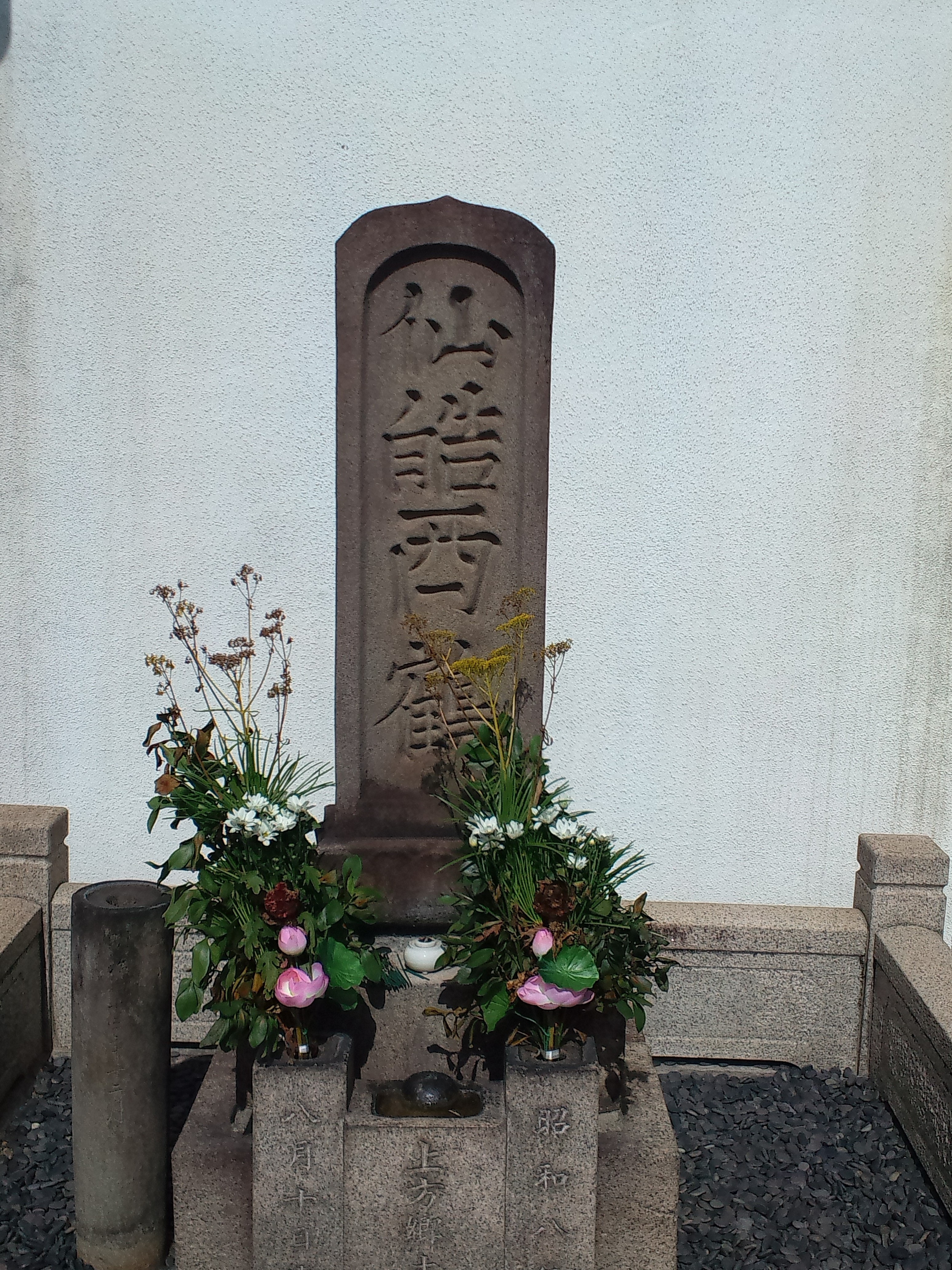
36:
413:object of statement has role
364:Items portrayed in this file
961:Date and time of digitizing
1124:
1054:Supported Flashpix version
789:Usage on zh.wikipedia.org
779:Usage on www.wikidata.org
764:Usage on ja.wikipedia.org
754:Usage on es.wikipedia.org
744:Usage on ca.wikipedia.org
311:same or compatible license
1083:2-dimensional measurement
969:Meaning of each component
653:
218:
189:Tomb of Ihara Saikaku.jpg
16:
903:0 meters above sea level
341:
277:
108:This is a file from the
1039:Center weighted average
710:
224:
214:
207:
204:
186:
112:. Information from its
176:34.668681; 135.519931
115:description page there
46:Size of this preview:
1088:Measurement precision
1026:Maximum land aperture
964:08:58, 16 August 2012
916:Horizontal resolution
868:08:58, 16 August 2012
689:18:19, 19 August 2012
839:1/2,500 sec (0.0004)
74:3,096 × 4,128 pixels
70:1,536 × 2,048 pixels
942:Y and C positioning
924:Vertical resolution
814:Camera manufacturer
292:– to adapt the work
52:Other resolutions:
441:Wikimedia username
428:author name string
66:768 × 1,024 pixels
1111:
1110:
1104:Rating (out of 5)
936:Windows Phone 7.5
895:135° 31′ 11.75″ E
736:Global file usage
713:
520:copyright license
350:
234:
233:
181:
180:
130:
129:
110:Wikimedia Commons
32:Global file usage
1115:
1080:Measurement mode
811:
701:
484:copyright status
465:
460:
450:
445:
435:
432:
422:
417:
333:
330:
327:
324:
321:
313:as the original.
270:Creative Commons
264:
263:
259:
258:
253:
252:
220:
210:
198:
190:
184:
177:
174:
160:
159:
153:
152:
141:
126:
105:
104:
98:
92:
90:
77:
62:576 × 768 pixels
58:360 × 480 pixels
54:180 × 240 pixels
48:450 × 600 pixels
1123:
1122:
1118:
1117:
1116:
1114:
1113:
1112:
1096:GPS tag version
1072:Unique image ID
1029:3 APEX (f/2.83)
1011:10.259292602539
1008:APEX brightness
1003:2.9708404541016
995:11.317016601562
887:34° 40′ 7.25″ N
799:
734:
721:
714:
707:
699:
655:
654:
651:
650:
649:
648:
647:
646:
645:
644:
642:
632:
631:
630:
628:
617:
616:
615:
614:
613:
612:
611:
610:
608:
596:
595:
594:
592:
581:
580:
579:
578:
577:
576:
575:
574:
572:
562:
561:
560:
558:
547:
546:
545:
544:
543:
542:
541:
540:
538:
526:
525:
524:
522:
511:
510:
509:
508:
507:
506:
505:
504:
502:
490:
489:
488:
486:
475:
474:
473:
472:
471:
470:
469:
468:
467:
466:
461:
458:
452:
451:
446:
443:
437:
436:
433:
430:
424:
423:
418:
415:
406:
405:
404:
402:
392:
391:
390:
388:
377:
376:
375:
374:
373:
371:
355:
354:
353:
336:
335:
334:
331:
328:
325:
322:
319:
318:
276:
265:
246:
245:
240:
235:
200:
188:
175:
148:
147:
144:Camera location
139:
132:
131:
120:
119:
118:is shown below.
94:
88:
86:
79:
78:
51:
12:
11:
5:
1121:
1119:
1109:
1108:
1105:
1101:
1100:
1097:
1093:
1092:
1089:
1085:
1084:
1081:
1077:
1076:
1073:
1069:
1068:
1065:
1059:
1058:
1055:
1051:
1050:
1047:
1041:
1040:
1037:
1031:
1030:
1027:
1023:
1022:
1019:
1013:
1012:
1009:
1005:
1004:
1001:
997:
996:
993:
987:
986:
985:
984:
983:does not exist
981:
978:
975:
970:
966:
965:
962:
958:
957:
954:
947:
946:
943:
939:
938:
933:
929:
928:
925:
921:
920:
917:
913:
912:
909:
905:
904:
901:
897:
896:
893:
889:
888:
885:
881:
880:
877:
870:
869:
866:
862:
861:
858:
851:
850:
847:
841:
840:
837:
831:
830:
825:
821:
820:
815:
802:
798:
797:
796:
795:
787:
786:
785:
777:
776:
775:
770:
762:
761:
760:
752:
751:
750:
738:
737:
733:
732:
727:
719:
718:
717:
712:
711:
709:
705:
702:
698:3,096 × 4,128
696:
691:
686:
682:
681:
678:
675:
672:
669:
666:
659:
658:
643:
640:
638:
637:
636:
635:
634:
633:
629:
624:
622:
621:
620:
619:
609:
604:
602:
601:
600:
599:
598:
597:
593:
590:source of file
588:
586:
585:
584:
583:
582:
573:
571:16 August 2012
570:
568:
567:
566:
565:
564:
563:
559:
554:
552:
551:
550:
549:
548:
539:
534:
532:
531:
530:
529:
528:
527:
523:
518:
516:
515:
514:
513:
512:
503:
498:
496:
495:
494:
493:
492:
491:
487:
482:
480:
479:
478:
477:
476:
454:
453:
439:
438:
426:
425:
411:
410:
409:
408:
407:
403:
400:
398:
397:
396:
395:
394:
393:
389:
384:
382:
381:
380:
379:
378:
372:
367:
365:
362:
361:
360:
359:
358:
347:
346:
343:
340:
317:
316:
315:
314:
304:
295:
294:
293:
287:
280:You are free:
267:
266:
248:
242:
241:
239:
236:
232:
231:
226:
222:
221:
216:
212:
211:
209:16 August 2012
206:
202:
201:
191:
182:
179:
178:
168:
162:
145:
138:
135:
133:
128:
127:
106:
96:
95:
45:
41:
40:
39:
34:
29:
24:
19:
13:
10:
9:
6:
4:
3:
2:
1120:
1106:
1103:
1098:
1095:
1090:
1087:
1082:
1079:
1074:
1071:
1066:
1064:
1061:
1056:
1053:
1048:
1046:
1043:
1038:
1036:
1035:Metering mode
1033:
1028:
1025:
1020:
1018:
1017:Exposure bias
1015:
1010:
1007:
1002:
1000:APEX aperture
999:
994:
992:
991:Shutter speed
989:
982:
979:
976:
973:
972:
971:
968:
963:
960:
955:
952:
949:
944:
941:
937:
934:
932:Software used
931:
926:
923:
918:
915:
910:
907:
902:
899:
894:
891:
886:
883:
878:
876:
872:
867:
864:
859:
856:
853:
848:
846:
843:
838:
836:
835:Exposure time
833:
829:
826:
823:
819:
816:
813:
809:
806:
800:
794:
791:
790:
788:
784:
781:
780:
778:
774:
771:
769:
766:
765:
763:
759:
758:Ihara Saikaku
756:
755:
753:
749:
748:Ihara Saikaku
746:
745:
743:
742:
741:
735:
731:
728:
726:
725:Ihara Saikaku
723:
715:
708:
703:
697:
695:
692:
690:
687:
684:
683:
679:
676:
673:
670:
667:
665:
664:
662:
656:
627:
607:
591:
557:
537:
521:
501:
485:
464:
457:
449:
442:
429:
421:
414:
387:
370:
323:CC BY-SA 3.0
312:
308:
305:
302:
299:
298:
296:
291:
288:
285:
282:
281:
279:
278:
274:
271:
254:
237:
230:
227:
223:
217:
213:
203:
197:
192:
185:
173:
169:
167:
166:OpenStreetMap
163:
161:
151:
146:
142:
136:
124:
117:
116:
111:
107:
100:
99:
93:
84:
83:Original file
75:
71:
67:
63:
59:
55:
49:
44:
38:
35:
33:
30:
28:
25:
23:
20:
18:
15:
1091:Poor (3,000)
875:focal length
824:Camera model
807:
804:
739:
660:
657:File history
420:photographer
306:
300:
289:
283:
195:
123:You can help
113:
81:
22:File history
1063:Color space
908:Orientation
500:copyrighted
307:share alike
301:attribution
187:Description
716:File usage
674:Dimensions
401:some value
89:image/jpeg
27:File usage
892:Longitude
855:ISO speed
706:Yanajin33
700:(3.43 MB)
671:Thumbnail
668:Date/Time
556:inception
448:Yanajin33
434:Yanajin33
238:Licensing
229:Yanajin33
945:Centered
900:Altitude
884:Latitude
845:F-number
801:Metadata
345:Captions
290:to remix
284:to share
275:license.
219:Own work
37:Metadata
1099:2.2.0.0
953:version
818:TOSHIBA
783:Q352561
685:current
680:Comment
386:creator
369:depicts
349:English
137:Summary
85:
927:72 dpi
919:72 dpi
911:Normal
879:4.6 mm
857:rating
225:Author
215:Source
199:井原西鶴の墓
154:
1045:Flash
873:Lens
849:f/2.8
828:IS12T
1067:sRGB
951:Exif
793:井原西鶴
768:井原西鶴
677:User
332:true
329:true
205:Date
196:日本語:
17:File
956:2.2
456:URL
980:Cr
977:Cb
860:50
459::
444::
431::
416::
72:|
68:|
64:|
60:|
56:|
50:.
1107:0
1057:1
1021:0
974:Y
125:.
91:)
76:.
Text is available under the Creative Commons Attribution-ShareAlike License. Additional terms may apply.