38:
232:
323:
238:
243:
94:
612:
284:– You must give appropriate credit, provide a link to the license, and indicate if changes were made. You may do so in any reasonable manner, but not in any way that suggests the licensor endorses you or your use.
983:
68:
64:
60:
56:
52:
48:
42:
105:
77:
340:
338:; with no Invariant Sections, no Front-Cover Texts, and no Back-Cover Texts. A copy of the license is included in the section entitled
330:
699:
694:
557:
487:
470:
434:
291:
541:
418:
335:
671:
507:
454:
401:
253:
729:
611:
606:
37:
647:
The following pages on the
English Knowledge (XXG) use this file (pages on other projects are not listed):
290:– If you remix, transform, or build upon the material, you must distribute your contributions under the
250:
666:
113:
317:
328:
Permission is granted to copy, distribute and/or modify this document under the terms of the
149:
225:
I, the copyright holder of this work, hereby publish it under the following licenses:
100:
689:
187:
179:
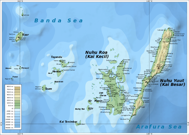
Topography was derived from data from the
Shuttle Radar Topography Mission (SRTM)
656:
630:
208:
637:|Date =2010-10-18 |Permission = |other_versions = }} [[Category:
161:
634:
622:
661:
651:
633:.}} |Source ={{own}} – self-made in Inkscape |Author =
194:
579:
Click on a date/time to view the file as it appeared at that time.
844:
874:
88:
894:
769:
719:
180:
82:(SVG file, nominally 1,753 × 1,256 pixels, file size: 492 KB)
889:
814:
764:
759:
954:
794:
944:
934:
929:
859:
854:
804:
784:
774:
974:
869:
819:
809:
799:
789:
754:
709:
949:
924:
839:
834:
779:
385:
Add a one-line explanation of what this file represents
904:
884:
749:
739:
919:
909:
964:
899:
488:
Creative
Commons Attribution-ShareAlike 3.0 Unported
471:
334:, Version 1.2 or any later version published by the
132:
112:
Commons is a freely licensed media file repository.
939:
879:
914:
849:
829:
864:
629:{{Information |Description ={{en|1=Map of the
301:https://creativecommons.org/licenses/by-sa/3.0
93:
307:Creative Commons Attribution-Share Alike 3.0
231:
8:
267:– to copy, distribute and transmit the work
41:Size of this PNG preview of this SVG file:
581:
381:
366:You may select the license of your choice.
682:The following other wikis use this file:
138:Topographic map of the Kai Islands-en.svg
649:
555:
539:
521:
505:
485:
468:
452:
432:
416:
399:
396:
377:
370:
186:Bathymetry was derived from data from
7:
346:http://www.gnu.org/copyleft/fdl.html
254:Attribution-Share Alike 3.0 Unported
570:
242:
237:
390:
384:
365:
228:
224:
142:
125:
75:
389:
375:
322:
321:
278:Under the following conditions:
249:This file is licensed under the
241:
236:
230:
92:
31:
21:
372:
143:
14:
371:
352:GNU Free Documentation License
341:GNU Free Documentation License
331:GNU Free Documentation License
26:
1:
558:original creation by uploader
397:Items portrayed in this file
961:Usage on en.wikivoyage.org
746:Usage on ceb.wikipedia.org
716:Usage on bar.wikipedia.org
706:Usage on ast.wikipedia.org
672:User talk:Mysid/Archive2011
193:Place names are based on a
1000:
971:Usage on eo.wikipedia.org
826:Usage on de.wikipedia.org
736:Usage on ca.wikipedia.org
726:Usage on bg.wikipedia.org
686:Usage on ar.wikipedia.org
292:same or compatible license
571:
175:– self-made in Inkscape.
172:
16:
374:
336:Free Software Foundation
258:
197:by the Malra Foundation.
181:as modified by CGIAR-CSI
99:This is a file from the
628:
203:
167:
160:
157:
135:
103:. Information from its
106:description page there
607:07:45, 18 April 2011
69:1,753 × 1,256 pixels
65:2,560 × 1,834 pixels
273:– to adapt the work
47:Other resolutions:
667:User:Mysid/vectors
61:1,280 × 917 pixels
57:1,024 × 734 pixels
984:more global usage
678:Global file usage
640:
455:copyright license
383:
363:
362:
215:
214:
121:
120:
101:Wikimedia Commons
32:Global file usage
991:
895:Nota (Kei Besar)
700:جزيرة كاي الكبرى
695:جزيرة كاي الصغرى
619:
419:copyright status
359:
356:
353:
350:
347:
325:
324:
318:
314:
311:
308:
305:
302:
294:as the original.
251:Creative Commons
245:
244:
240:
239:
234:
233:
174:
163:
147:
139:
133:
117:
96:
95:
89:
83:
72:
53:640 × 459 pixels
49:320 × 229 pixels
43:800 × 573 pixels
999:
998:
994:
993:
992:
990:
989:
988:
890:Wat (Kei Besar)
770:Pulau-Pulau Kai
720:Wat (Kei Besar)
676:
648:
641:
625:
617:
573:
572:
569:
568:
567:
566:
565:
564:
563:
562:
560:
548:
547:
546:
544:
533:
532:
531:
530:
529:
528:
527:
526:
524:
514:
513:
512:
510:
499:
498:
497:
496:
495:
494:
493:
492:
490:
479:
478:
477:
476:
475:
473:
461:
460:
459:
457:
446:
445:
444:
443:
442:
441:
440:
439:
437:
425:
424:
423:
421:
410:
409:
408:
407:
406:
404:
388:
387:
386:
369:
368:
367:
357:
354:
351:
348:
345:
316:
315:
312:
309:
306:
303:
300:
299:
257:
246:
227:
226:
221:
216:
207:Oona Räisänen (
153:
137:
130:
123:
122:
111:
110:
109:is shown below.
85:
81:
74:
73:
46:
12:
11:
5:
997:
995:
986:of this file.
980:
979:
978:
977:
969:
968:
967:
959:
958:
957:
952:
947:
942:
937:
932:
927:
922:
917:
912:
907:
902:
897:
892:
887:
882:
877:
872:
867:
862:
857:
852:
847:
845:Südostmolukken
842:
837:
832:
824:
823:
822:
817:
815:Pulau Nuhuyaan
812:
807:
802:
797:
792:
787:
782:
777:
772:
767:
765:Pulau Kaidulah
762:
757:
752:
744:
743:
742:
734:
733:
732:
724:
723:
722:
714:
713:
712:
704:
703:
702:
697:
692:
680:
679:
675:
674:
669:
664:
659:
654:
646:
645:
644:
639:
638:
627:
623:
620:
616:1,753 × 1,256
614:
609:
604:
600:
599:
596:
593:
590:
587:
584:
577:
576:
561:
556:
554:
553:
552:
551:
550:
549:
545:
542:source of file
540:
538:
537:
536:
535:
534:
525:
522:
520:
519:
518:
517:
516:
515:
511:
506:
504:
503:
502:
501:
500:
491:
486:
484:
483:
482:
481:
480:
474:
469:
467:
466:
465:
464:
463:
462:
458:
453:
451:
450:
449:
448:
447:
438:
433:
431:
430:
429:
428:
427:
426:
422:
417:
415:
414:
413:
412:
411:
405:
400:
398:
395:
394:
393:
392:
391:
380:
379:
376:
373:
364:
361:
360:
326:
298:
297:
296:
295:
285:
276:
275:
274:
268:
261:You are free:
248:
247:
229:
223:
222:
220:
217:
213:
212:
205:
201:
200:
199:
198:
191:
184:
169:
165:
164:
159:
155:
154:
140:
131:
129:
126:
124:
119:
118:
97:
87:
86:
40:
36:
35:
34:
29:
24:
19:
13:
10:
9:
6:
4:
3:
2:
996:
987:
985:
976:
973:
972:
970:
966:
963:
962:
960:
956:
955:Tayandoinseln
953:
951:
948:
946:
943:
941:
938:
936:
933:
931:
928:
926:
923:
921:
918:
916:
913:
911:
908:
906:
903:
901:
898:
896:
893:
891:
888:
886:
883:
881:
878:
876:
873:
871:
868:
866:
863:
861:
858:
856:
853:
851:
848:
846:
843:
841:
838:
836:
833:
831:
828:
827:
825:
821:
818:
816:
813:
811:
808:
806:
803:
801:
798:
796:
793:
791:
788:
786:
783:
781:
778:
776:
773:
771:
768:
766:
763:
761:
760:Muhanuhujanat
758:
756:
753:
751:
748:
747:
745:
741:
738:
737:
735:
731:
730:Кай (острови)
728:
727:
725:
721:
718:
717:
715:
711:
708:
707:
705:
701:
698:
696:
693:
691:
688:
687:
685:
684:
683:
677:
673:
670:
668:
665:
663:
660:
658:
655:
653:
650:
642:
636:
632:
626:
621:
615:
613:
610:
608:
605:
602:
601:
597:
594:
591:
588:
585:
583:
582:
580:
574:
559:
543:
523:18 April 2011
509:
489:
472:
456:
436:
420:
403:
343:
342:
337:
333:
332:
327:
320:
319:
304:CC BY-SA 3.0
293:
289:
286:
283:
280:
279:
277:
272:
269:
266:
263:
262:
260:
259:
255:
252:
235:
218:
210:
206:
202:
196:
192:
189:
185:
182:
178:
177:
176:
170:
166:
162:18 April 2011
156:
151:
146:
141:
134:
127:
115:
108:
107:
102:
98:
91:
90:
84:
79:
78:Original file
70:
66:
62:
58:
54:
50:
44:
39:
33:
30:
28:
25:
23:
20:
18:
15:
981:
945:Beor (Insel)
935:Fair (Insel)
930:Krus (Insel)
875:Nerongstraße
860:Moanumayanat
855:Kran (Insel)
795:Pulau Dranan
681:
578:
575:File history
339:
329:
287:
281:
270:
264:
171:
144:
114:You can help
104:
76:
22:File history
975:Kai-insuloj
870:Kur (Insel)
805:Pulau Dufin
785:Pulau Duroa
775:Pulau Godon
657:Kai Islands
631:Kai Islands
435:copyrighted
288:share alike
282:attribution
188:SRTM30_PLUS
150:Kai Islands
148:Map of the
136:Description
950:Er (Insel)
925:Ut (Insel)
840:Kei Dullah
835:Kei-Inseln
820:Pulau Fair
810:Pulau Aran
800:Pulau Krus
790:Pulau Kran
755:Pulau Ubur
710:Islles Kai
643:File usage
592:Dimensions
27:File usage
905:Aran Laai
885:Nuhuyanan
780:Pulau Ler
740:Illes Kai
662:Kai Kecil
652:Kai Besar
589:Thumbnail
586:Date/Time
508:inception
219:Licensing
145:English:
920:Nasu Lar
910:Aran Kot
750:Pulau Ut
618:(492 KB)
378:Captions
271:to remix
265:to share
256:license.
195:JPEG map
173:Own work
900:Masular
690:جزر كاي
603:current
598:Comment
402:depicts
382:English
128:Summary
80:
965:Maluku
940:Ngodan
880:Dranan
204:Author
168:Source
982:View
915:Dufin
850:Duroa
830:Karod
635:Mysid
624:Mysid
209:Mysid
865:Ubur
595:User
358:true
355:true
349:GFDL
313:true
310:true
158:Date
17:File
67:|
63:|
59:|
55:|
51:|
45:.
344:.
211:)
190:.
183:.
152:.
116:.
71:.
Text is available under the Creative Commons Attribution-ShareAlike License. Additional terms may apply.
