38:
253:
259:
264:
94:
549:
311:– You must give appropriate credit, provide a link to the license, and indicate if changes were made. You may do so in any reasonable manner, but not in any way that suggests the licensor endorses you or your use.
570:, UK with the following information shown: *Administrative borders *Coastline, lakes and rivers *Roads and railways *Urban areas Equirectangular map projection on WGS 84 datum, with N/S stretche
659:
759:
932:
779:
769:
764:
774:
669:
68:
64:
60:
56:
52:
48:
42:
734:
242:
105:
664:
77:
460:
424:
922:
599:
213:
318:
917:
847:
689:
408:
674:
480:
444:
391:
644:
609:
274:
580:
The following pages on the
English Knowledge (XXG) use this file (pages on other projects are not listed):
317:– If you remix, transform, or build upon the material, you must distribute your contributions under the
1057:
604:
271:
1067:
729:
351:
199:
997:
634:
629:
594:
113:
872:
797:
1097:
1052:
548:
543:
37:
654:
619:
196:
1022:
852:
1082:
1042:
1017:
559:
217:
882:
754:
649:
614:
100:
1077:
1037:
827:
230:
1122:
1107:
912:
639:
185:
719:
714:
704:
684:
679:
584:
837:
749:
744:
724:
589:
987:
962:
139:
1117:
982:
967:
159:
Equirectangular map projection on WGS 84 datum, with N/S stretched 160%
739:
709:
694:
624:
567:
699:
206:
Administrative borders and coastline data from
Boundary-Line product.
848:
Wikiproyecto:Ilustración/Taller de
Cartografía/Realizaciones/Europa
516:
Click on a date/time to view the file as it appeared at that time.
282:
Contains
Ordnance Survey data © Crown copyright and database right
88:
82:(SVG file, nominally 1,187 × 1,266 pixels, file size: 496 KB)
1027:
807:
972:
660:
List of Sites of
Special Scientific Interest in Torfaen
375:
Add a one-line explanation of what this file represents
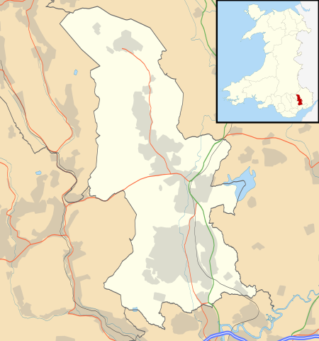
1092:
1007:
957:
952:
902:
857:
817:
947:
942:
892:
862:
461:
Creative
Commons Attribution-ShareAlike 3.0 Unported
127:
112:
Commons is a freely licensed media file repository.
209:All other geographic data from Meridian 2 product.
760:User:Robevans123/sandbox/All Saints, Llanfrechfa
998:Format:Harta de localizare Țara Galilor Torfaen
1058:Modül:Konum haritası/veri/Galler Torfaen/belge
328:https://creativecommons.org/licenses/by-sa/3.0
93:
334:Creative Commons Attribution-Share Alike 3.0
252:
8:
294:– to copy, distribute and transmit the work
142:, UK with the following information shown:
41:Size of this PNG preview of this SVG file:
1083:Module:Location map/data/Wales Torfaen/doc
1043:Module:Location map/data/Wales Torfaen/doc
1023:Module:Location map/data/Wales Torfaen/doc
780:Module:Location map/data/Wales Torfaen/doc
518:
371:
923:モジュール:Location map/data/Wales Torfaen/doc
853:Plantilla:Mapa de localización de Torfaen
790:The following other wikis use this file:
770:User:Robevans123/sandbox/Henllys, Torfaen
1053:Modül:Konum haritası/veri/Galler Torfaen
765:User:Robevans123/sandbox/Cwmbran Central
566:{{Information |Description=Blank map of
582:
494:
478:
458:
442:
422:
406:
389:
386:
367:
360:
1078:Module:Location map/data/Wales Torfaen
1038:Module:Location map/data/Wales Torfaen
1018:Module:Location map/data/Wales Torfaen
775:Module:Location map/data/Wales Torfaen
670:List of scheduled monuments in Torfaen
918:モジュール:Location map/data/Wales Torfaen
214:File: United Kingdom location map.svg
7:
933:ಟೆಂಪ್ಲೇಟು:Location map Wales Torfaen
828:Plantilya:Location map Wales Torfaen
735:St Michael's Church, Llantarnam
275:Attribution-Share Alike 3.0 Unported
233:, created using Ordnance Survey data
1123:Template:Location map Wales Torfaen
913:Template:Location map Wales Torfaen
507:
263:
258:
1108:Batakan:Location map Wales Torfaen
1098:Bản mẫu:Location map Wales Torfaen
380:
374:
249:
125:
75:
379:
838:Nodyn:Location map Wales Torfaen
665:List of monastic houses in Wales
365:
305:Under the following conditions:
270:This file is licensed under the
262:
257:
251:
92:
31:
21:
873:الگو:Location map Wales Torfaen
798:قالب:Location map Wales Torfaen
362:
14:
1014:Usage on simple.wikipedia.org
883:Modèle:Géolocalisation/Torfaen
600:Blaenavon Industrial Landscape
361:
26:
1:
690:Municipal Offices, Blaenavon
387:Items portrayed in this file
1104:Usage on war.wikipedia.org
824:Usage on ceb.wikipedia.org
804:Usage on bar.wikipedia.org
675:Llanfrechfa Grange Hospital
149:Coastline, lakes and rivers
133:Torfaen UK location map.svg
1141:
1114:Usage on zh.wikipedia.org
1089:Usage on vi.wikipedia.org
1074:Usage on uz.wikipedia.org
1064:Usage on uk.wikipedia.org
1049:Usage on tr.wikipedia.org
1034:Usage on si.wikipedia.org
1004:Usage on sh.wikipedia.org
994:Usage on ro.wikipedia.org
979:Usage on pl.wikibooks.org
939:Usage on pl.wikipedia.org
929:Usage on kn.wikipedia.org
909:Usage on ja.wikipedia.org
899:Usage on hr.wikipedia.org
889:Usage on gv.wikipedia.org
879:Usage on fr.wikipedia.org
869:Usage on fa.wikipedia.org
844:Usage on es.wikipedia.org
834:Usage on cy.wikipedia.org
814:Usage on br.wikipedia.org
794:Usage on ar.wikipedia.org
645:Grange University Hospital
319:same or compatible license
508:
16:
610:County Hospital, Torfaen
544:19:45, 26 September 2010
364:
285:
99:This is a file from the
988:Moduł:Mapa/dane/Torfaen
963:Moduł:Mapa/dane/Torfaen
565:
352:File:Torfaen UK map.svg
347:
237:
226:
191:
184:
181:
130:
103:. Information from its
983:Moduł:Mapa/dane/GB-TOF
968:Moduł:Mapa/dane/GB-TOF
146:Administrative borders
106:description page there
605:County Hall, Cwmbran
69:1,187 × 1,266 pixels
65:1,920 × 2,048 pixels
730:Pontypool Town Hall
300:– to adapt the work
212:Inset derived from
162:Geographic limits:
47:Other resolutions:
635:Forge Row, Cwmavon
630:Fairwater, Torfaen
595:Blaenavon Hospital
152:Roads and railways
61:960 × 1,024 pixels
786:Global file usage
573:
496:26 September 2010
445:copyright license
373:
358:
357:
246:
243:Reusing this file
186:26 September 2010
121:
120:
101:Wikimedia Commons
32:Global file usage
1132:
655:Henllys, Torfaen
620:Cwmavon, Torfaen
556:
409:copyright status
341:
338:
335:
332:
329:
321:as the original.
283:
272:Creative Commons
266:
265:
261:
260:
255:
254:
240:
187:
134:
128:
117:
96:
95:
89:
83:
72:
57:720 × 768 pixels
53:450 × 480 pixels
49:225 × 240 pixels
43:562 × 599 pixels
1140:
1139:
1135:
1134:
1133:
1131:
1130:
1129:
784:
581:
574:
562:
554:
510:
509:
506:
505:
504:
503:
502:
501:
500:
499:
497:
487:
486:
485:
483:
472:
471:
470:
469:
468:
467:
466:
465:
463:
451:
450:
449:
447:
436:
435:
434:
433:
432:
431:
430:
429:
427:
415:
414:
413:
411:
400:
399:
398:
397:
396:
394:
378:
377:
376:
359:
343:
342:
339:
336:
333:
330:
327:
326:
284:
281:
278:
267:
197:Ordnance Survey
132:
123:
122:
111:
110:
109:is shown below.
85:
81:
74:
73:
46:
12:
11:
5:
1138:
1136:
1128:
1127:
1126:
1125:
1120:
1112:
1111:
1110:
1102:
1101:
1100:
1095:
1087:
1086:
1085:
1080:
1072:
1071:
1070:
1062:
1061:
1060:
1055:
1047:
1046:
1045:
1040:
1032:
1031:
1030:
1025:
1020:
1012:
1011:
1010:
1002:
1001:
1000:
992:
991:
990:
985:
977:
976:
975:
970:
965:
960:
955:
950:
945:
937:
936:
935:
927:
926:
925:
920:
915:
907:
906:
905:
897:
896:
895:
887:
886:
885:
877:
876:
875:
867:
866:
865:
860:
855:
850:
842:
841:
840:
832:
831:
830:
822:
821:
820:
812:
811:
810:
802:
801:
800:
788:
787:
783:
782:
777:
772:
767:
762:
757:
752:
747:
742:
737:
732:
727:
722:
717:
712:
707:
702:
697:
692:
687:
682:
677:
672:
667:
662:
657:
652:
647:
642:
637:
632:
627:
622:
617:
612:
607:
602:
597:
592:
587:
579:
578:
577:
572:
571:
564:
560:
557:
553:1,187 × 1,266
551:
546:
541:
537:
536:
533:
530:
527:
524:
521:
514:
513:
498:
495:
493:
492:
491:
490:
489:
488:
484:
479:
477:
476:
475:
474:
473:
464:
459:
457:
456:
455:
454:
453:
452:
448:
443:
441:
440:
439:
438:
437:
428:
423:
421:
420:
419:
418:
417:
416:
412:
407:
405:
404:
403:
402:
401:
395:
390:
388:
385:
384:
383:
382:
381:
370:
369:
366:
363:
356:
355:
349:
348:Other versions
345:
344:
325:
324:
323:
322:
312:
303:
302:
301:
295:
288:You are free:
279:
269:
268:
250:
247:
235:
234:
228:
224:
223:
222:
221:
210:
207:
193:
189:
188:
183:
179:
178:
177:
176:
173:
170:
167:
157:
156:
153:
150:
147:
135:
126:
124:
119:
118:
97:
87:
86:
40:
36:
35:
34:
29:
24:
19:
13:
10:
9:
6:
4:
3:
2:
1137:
1124:
1121:
1119:
1116:
1115:
1113:
1109:
1106:
1105:
1103:
1099:
1096:
1094:
1091:
1090:
1088:
1084:
1081:
1079:
1076:
1075:
1073:
1069:
1066:
1065:
1063:
1059:
1056:
1054:
1051:
1050:
1048:
1044:
1041:
1039:
1036:
1035:
1033:
1029:
1026:
1024:
1021:
1019:
1016:
1015:
1013:
1009:
1006:
1005:
1003:
999:
996:
995:
993:
989:
986:
984:
981:
980:
978:
974:
971:
969:
966:
964:
961:
959:
956:
954:
951:
949:
946:
944:
941:
940:
938:
934:
931:
930:
928:
924:
921:
919:
916:
914:
911:
910:
908:
904:
901:
900:
898:
894:
891:
890:
888:
884:
881:
880:
878:
874:
871:
870:
868:
864:
861:
859:
856:
854:
851:
849:
846:
845:
843:
839:
836:
835:
833:
829:
826:
825:
823:
819:
816:
815:
813:
809:
806:
805:
803:
799:
796:
795:
793:
792:
791:
785:
781:
778:
776:
773:
771:
768:
766:
763:
761:
758:
756:
755:Upper Cwmbran
753:
751:
748:
746:
743:
741:
738:
736:
733:
731:
728:
726:
723:
721:
718:
716:
713:
711:
708:
706:
703:
701:
698:
696:
693:
691:
688:
686:
683:
681:
678:
676:
673:
671:
668:
666:
663:
661:
658:
656:
653:
651:
650:Griffithstown
648:
646:
643:
641:
638:
636:
633:
631:
628:
626:
623:
621:
618:
616:
615:Croesyceiliog
613:
611:
608:
606:
603:
601:
598:
596:
593:
591:
588:
586:
583:
575:
569:
563:
558:
552:
550:
547:
545:
542:
539:
538:
534:
531:
528:
525:
522:
520:
519:
517:
511:
482:
462:
446:
426:
410:
393:
353:
350:
346:
331:CC BY-SA 3.0
320:
316:
313:
310:
307:
306:
304:
299:
296:
293:
290:
289:
287:
286:
280:Attribution:
276:
273:
256:
248:
244:
239:
236:
232:
229:
225:
219:
215:
211:
208:
205:
204:
203:
201:
198:
194:
190:
180:
175:South: 51.60N
174:
172:North: 51.80N
171:
168:
165:
164:
163:
160:
154:
151:
148:
145:
144:
143:
141:
138:Blank map of
136:
129:
115:
108:
107:
102:
98:
91:
90:
84:
79:
78:Original file
70:
66:
62:
58:
54:
50:
44:
39:
33:
30:
28:
25:
23:
20:
18:
15:
789:
515:
512:File history
314:
308:
297:
291:
218:NordNordWest
195:
161:
158:
137:
114:You can help
104:
76:
22:File history
640:Garn-yr-erw
425:copyrighted
354:- Blank map
315:share alike
309:attribution
169:East: 2.90W
166:West: 3.20W
155:Urban areas
131:Description
973:Abersychan
808:Abersychan
720:Pontymoile
715:Pontnewydd
705:Pen Tranch
685:Llanyrafon
680:Llantarnam
585:Abersychan
576:File usage
529:Dimensions
238:Permission
27:File usage
1093:Blaenavon
1068:Блайневон
1028:Blaenavon
1008:Blaenavon
958:Blaenavon
953:Pontypool
903:Blaenavon
858:Pontypool
818:Fairwater
750:Two Locks
745:Trevethin
725:Pontypool
590:Blaenavon
561:Nilfanion
526:Thumbnail
523:Date/Time
481:inception
231:Nilfanion
555:(496 KB)
368:Captions
298:to remix
292:to share
277:license.
200:OpenData
948:Cwmbran
943:Torfaen
893:Torfaen
863:Cwmbran
740:Torfaen
710:Ponthir
695:New Inn
625:Cwmbran
568:Torfaen
540:current
535:Comment
392:depicts
372:English
140:Torfaen
80:
700:Panteg
227:Author
192:Source
532:User
340:true
337:true
182:Date
17:File
1118:龐蒂浦
216:by
202:.
67:|
63:|
59:|
55:|
51:|
45:.
245:)
241:(
220:.
116:.
71:.
Text is available under the Creative Commons Attribution-ShareAlike License. Additional terms may apply.
