43:
267:
228:
220:
242:
273:
278:
589:"}},"text\/plain":{"en":{"":"heading"}}},"{\"value\":{\"amount\":\"+143.98823529411766\",\"unit\":\"http:\\\/\\\/www.wikidata.org\\\/entity\\\/Q28390\"},\"type\":\"quantity\"}":{"text\/html":{"en":{"P7787":"143.98823529411766
103:
585:
319:– You must give appropriate credit, provide a link to the license, and indicate if changes were made. You may do so in any reasonable manner, but not in any way that suggests the licensor endorses you or your use.
211:
69:
65:
61:
57:
53:
47:
586:
82:
114:
194:
672:
572:
536:
500:
235:
1050:
889:
This file contains additional information, probably added from the digital camera or scanner used to create or digitize it.
742:
326:
726:
656:
627:
600:
556:
484:
456:
443:
428:
692:
520:
401:
384:
593:"}},"text\/plain":{"en":{"P7787":"143.98823529411766 degree"}}}}": -->
463:
796:
791:
73:
42:
828:
288:
892:
If the file has been modified from its original state, some details may not fully reflect the modified file.
1116:
325:– If you remix, transform, or build upon the material, you must distribute your contributions under the
807:
285:
824:
The following pages on the
English Knowledge use this file (pages on other projects are not listed):
1136:
435:
122:
876:
1019:
174:
241:
1204:
1126:
1090:
918:
109:
260:
I, the copyright holder of this work, hereby publish it under the following license:
958:
225:
1170:
938:
901:
911:
928:
861:
866:
764:
Click on a date/time to view the file as it appeared at that time.
227:
212:
40° 40′ 07.31″ N, 2° 00′ 23.72″ W
202:
97:
537:
Creative
Commons Attribution-ShareAlike 4.0 International
368:
Add a one-line explanation of what this file represents
87:(4,032 × 3,024 pixels, file size: 4.35 MB, MIME type:
141:
121:
Commons is a freely licensed media file repository.
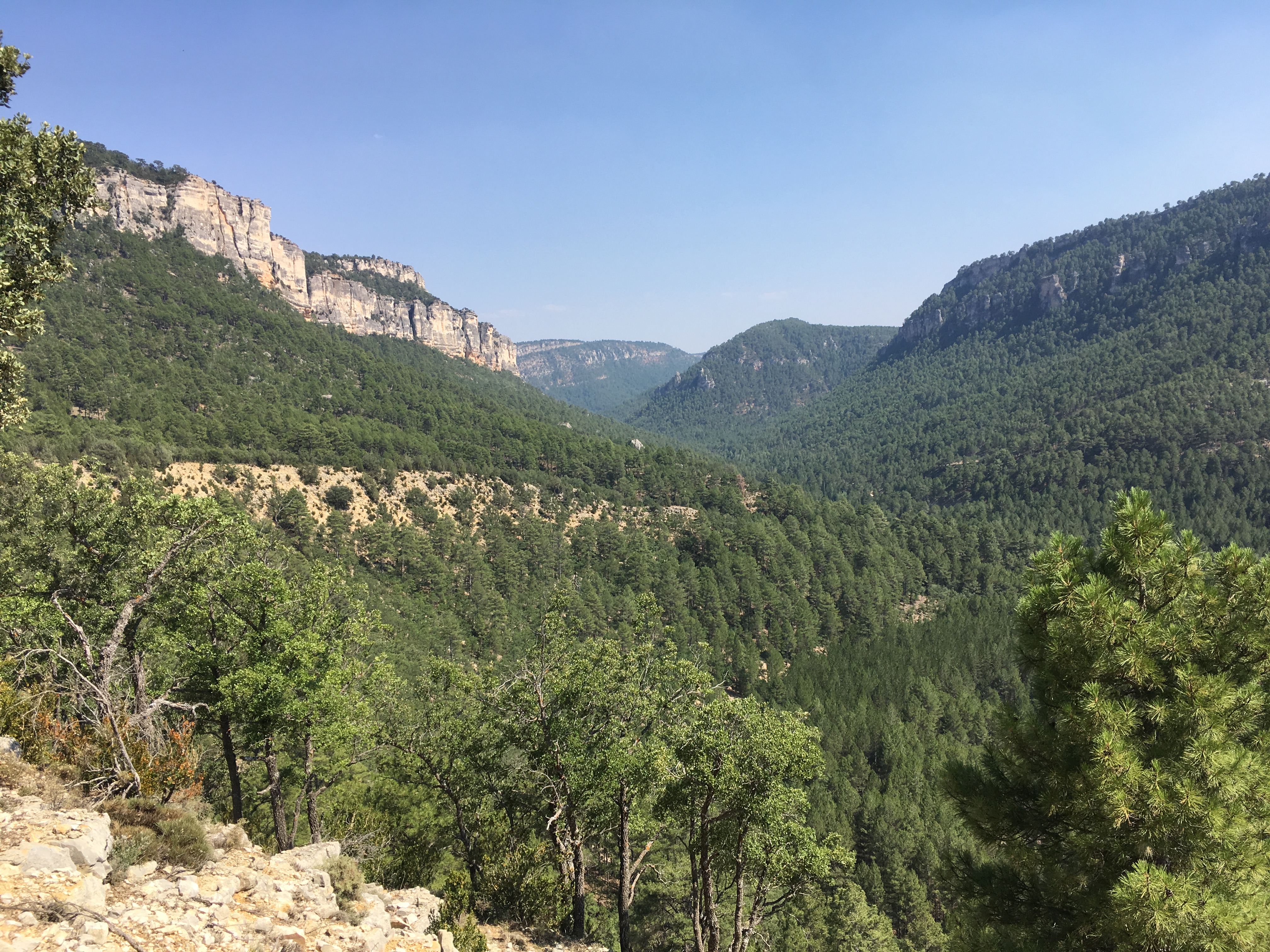
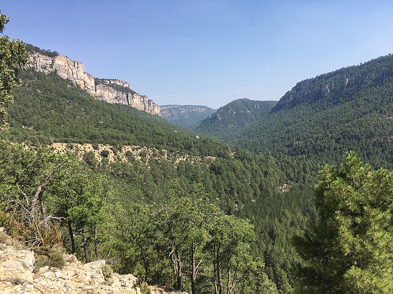
165:Parque Natural del Alto Tajo, Guadalajara (España)
856:
846:
1141:Flash did not fire, compulsory flash suppression
436:https://commons.wikimedia.org/user:Heparina1985
336:https://creativecommons.org/licenses/by-sa/4.0
102:
342:Creative Commons Attribution-Share Alike 4.0
266:
8:
590:
302:– to copy, distribute and transmit the work
894:
766:
364:
147:Tagus river gorge, Guadalajara (Spain).jpg
839:The following other wikis use this file:
289:Attribution-Share Alike 4.0 International
217:
1284:
1276:
1268:
1260:
1252:
1244:
1236:
1228:
1220:
1212:
1202:
1194:
1186:
1178:
1168:
1160:
1152:
1144:
1134:
1124:
1114:
1106:
1098:
1088:
1067:
1059:
1048:
1040:
1032:
1024:
1014:
1006:
998:
990:
982:
974:
966:
955:
947:
936:
926:
916:
906:
826:
740:
724:
706:
690:
670:
654:
614:
598:
570:
554:
534:
518:
498:
482:
415:
399:
382:
379:
360:
353:
205:
234:View this and other nearby images on:
157:Tagus river gorge, Guadalajara (Spain)
896:
7:
1270:Reference for bearing of destination
814:User created page with UploadWizard
755:
277:
272:
887:
373:
367:
263:
259:
159:
151:
134:
80:
923:1/1,183 sec (0.00084530853761623)
372:
1254:Reference for direction of image
987:1,177.141 meters above sea level
949:Date and time of data generation
601:coordinates of the point of view
358:
313:Under the following conditions:
284:This file is licensed under the
276:
271:
265:
240:
226:
218:
101:
31:
21:
355:
160:
152:
14:
354:
26:
1:
1191:A directly photographed image
573:original creation by uploader
36:
1154:DateTimeDigitized subseconds
862:Parque natural del Alto Tajo
380:Items portrayed in this file
1146:DateTimeOriginal subseconds
1061:Date and time of digitizing
616:40°40'7.309"N, 2°0'23.720"W
1306:
1214:Focal length in 35 mm film
1183:One-chip color area sensor
1162:Supported Flashpix version
873:Usage on fa.wikipedia.org
853:Usage on es.wikipedia.org
843:Usage on ca.wikipedia.org
673:iPhone SE (1st generation)
327:same or compatible license
1069:Meaning of each component
1026:File change date and time
756:
184:
16:
829:Alto Tajo Nature Reserve
357:
293:
108:This is a file from the
1230:GPS time (atomic clock)
813:
190:
180:
173:
170:
144:
112:. Information from its
1278:Bearing of destination
246:40.668697; -2.006589
175:28 July 2017, 16:46:27
115:description page there
46:Size of this preview:
1246:Speed of GPS receiver
1000:Horizontal resolution
727:location of creation
74:4,032 × 3,024 pixels
70:2,560 × 1,920 pixels
1241:Kilometers per hour
1064:16:46, 28 July 2017
1034:Y and C positioning
1029:16:46, 28 July 2017
1008:Vertical resolution
952:16:46, 28 July 2017
898:Camera manufacturer
792:22:04, 31 July 2018
634:143.98823529411766
308:– to adapt the work
52:Other resolutions:
1262:Direction of image
1222:Scene capture type
1209:Auto white balance
867:Serranía de Cuenca
457:Wikimedia username
444:author name string
66:1,280 × 960 pixels
62:1,024 × 768 pixels
1293:
1292:
835:Global file usage
817:
592:
521:copyright license
366:
251:
250:
200:
199:
130:
129:
110:Wikimedia Commons
32:Global file usage
1297:
1042:Exposure Program
895:
804:
638:
637:
632:
485:copyright status
466:
461:
451:
448:
438:
433:
349:
346:
343:
340:
337:
329:as the original.
286:Creative Commons
280:
279:
275:
274:
269:
268:
247:
244:
230:
229:
223:
222:
221:
215:
214:
203:
186:
176:
164:
156:
148:
142:
126:
105:
104:
98:
92:
90:
77:
58:640 × 480 pixels
54:320 × 240 pixels
48:800 × 600 pixels
1305:
1304:
1300:
1299:
1298:
1296:
1295:
1294:
1281:143.98823529412
1265:143.98823529412
1111:10.109050445104
1108:APEX brightness
1103:2.2750071245369
1095:10.208760484623
971:40° 40′ 7.31″ N
883:
833:
825:
818:
810:
802:
758:
757:
754:
753:
752:
751:
750:
749:
748:
747:
745:
733:
732:
731:
729:
718:
717:
716:
715:
714:
713:
712:
711:
709:
699:
698:
697:
695:
684:
683:
682:
681:
680:
679:
678:
677:
675:
663:
662:
661:
659:
648:
647:
646:
645:
644:
643:
642:
641:
640:
639:
635:
633:
630:
621:
620:
619:
617:
607:
606:
605:
603:
584:
583:
582:
581:
580:
579:
578:
577:
575:
563:
562:
561:
559:
548:
547:
546:
545:
544:
543:
542:
541:
539:
527:
526:
525:
523:
512:
511:
510:
509:
508:
507:
506:
505:
503:
491:
490:
489:
487:
476:
475:
474:
473:
472:
471:
470:
469:
468:
467:
462:
459:
453:
452:
449:
446:
440:
439:
434:
431:
422:
421:
420:
418:
408:
407:
406:
404:
393:
392:
391:
390:
389:
387:
371:
370:
369:
352:
351:
350:
347:
344:
341:
338:
335:
334:
292:
281:
262:
261:
256:
245:
219:
210:
209:
206:Camera location
201:
166:
158:
146:
139:
132:
131:
120:
119:
118:is shown below.
94:
88:
86:
79:
78:
51:
12:
11:
5:
1303:
1301:
1291:
1290:
1287:
1283:
1282:
1279:
1275:
1274:
1273:True direction
1271:
1267:
1266:
1263:
1259:
1258:
1257:True direction
1255:
1251:
1250:
1247:
1243:
1242:
1239:
1235:
1234:
1231:
1227:
1226:
1223:
1219:
1218:
1215:
1211:
1210:
1207:
1201:
1200:
1197:
1193:
1192:
1189:
1185:
1184:
1181:
1180:Sensing method
1177:
1176:
1173:
1167:
1166:
1163:
1159:
1158:
1155:
1151:
1150:
1147:
1143:
1142:
1139:
1133:
1132:
1129:
1123:
1122:
1119:
1113:
1112:
1109:
1105:
1104:
1101:
1097:
1096:
1093:
1087:
1086:
1085:
1084:
1083:does not exist
1081:
1078:
1075:
1070:
1066:
1065:
1062:
1058:
1057:
1054:
1047:
1046:
1045:Normal program
1043:
1039:
1038:
1035:
1031:
1030:
1027:
1023:
1022:
1017:
1013:
1012:
1009:
1005:
1004:
1001:
997:
996:
993:
989:
988:
985:
981:
980:
979:2° 0′ 23.72″ W
977:
973:
972:
969:
965:
964:
961:
954:
953:
950:
946:
945:
942:
935:
934:
931:
925:
924:
921:
915:
914:
909:
905:
904:
899:
886:
882:
881:
880:
879:
871:
870:
869:
864:
859:
851:
850:
849:
837:
836:
832:
831:
823:
822:
821:
816:
815:
812:
808:
805:
801:4,032 × 3,024
799:
794:
789:
785:
784:
781:
778:
775:
772:
769:
762:
761:
746:
741:
739:
738:
737:
736:
735:
734:
730:
725:
723:
722:
721:
720:
719:
710:
707:
705:
704:
703:
702:
701:
700:
696:
691:
689:
688:
687:
686:
685:
676:
671:
669:
668:
667:
666:
665:
664:
660:
655:
653:
652:
651:
650:
649:
626:
625:
624:
623:
622:
618:
615:
613:
612:
611:
610:
609:
608:
604:
599:
597:
596:
595:
594:
588:
576:
571:
569:
568:
567:
566:
565:
564:
560:
557:source of file
555:
553:
552:
551:
550:
549:
540:
535:
533:
532:
531:
530:
529:
528:
524:
519:
517:
516:
515:
514:
513:
504:
499:
497:
496:
495:
494:
493:
492:
488:
483:
481:
480:
479:
478:
477:
455:
454:
442:
441:
427:
426:
425:
424:
423:
419:
416:
414:
413:
412:
411:
410:
409:
405:
400:
398:
397:
396:
395:
394:
388:
383:
381:
378:
377:
376:
375:
374:
363:
362:
359:
356:
333:
332:
331:
330:
320:
311:
310:
309:
303:
296:You are free:
283:
282:
264:
258:
257:
255:
252:
249:
248:
238:
232:
207:
198:
197:
192:
188:
187:
182:
178:
177:
172:
168:
167:
149:
140:
138:
135:
133:
128:
127:
106:
96:
95:
45:
41:
40:
39:
34:
29:
24:
19:
13:
10:
9:
6:
4:
3:
2:
1302:
1288:
1285:
1280:
1277:
1272:
1269:
1264:
1261:
1256:
1253:
1248:
1245:
1240:
1237:
1232:
1229:
1224:
1221:
1216:
1213:
1208:
1206:
1205:White balance
1203:
1199:Auto exposure
1198:
1196:Exposure mode
1195:
1190:
1187:
1182:
1179:
1174:
1172:
1169:
1164:
1161:
1156:
1153:
1148:
1145:
1140:
1138:
1135:
1130:
1128:
1127:Metering mode
1125:
1120:
1118:
1117:Exposure bias
1115:
1110:
1107:
1102:
1100:APEX aperture
1099:
1094:
1092:
1091:Shutter speed
1089:
1082:
1079:
1076:
1073:
1072:
1071:
1068:
1063:
1060:
1055:
1052:
1049:
1044:
1041:
1036:
1033:
1028:
1025:
1021:
1018:
1016:Software used
1015:
1010:
1007:
1002:
999:
994:
991:
986:
983:
978:
975:
970:
967:
962:
960:
956:
951:
948:
943:
940:
937:
932:
930:
927:
922:
920:
919:Exposure time
917:
913:
910:
907:
903:
900:
897:
893:
890:
884:
878:
875:
874:
872:
868:
865:
863:
860:
858:
855:
854:
852:
848:
845:
844:
842:
841:
840:
834:
830:
827:
819:
811:
806:
800:
798:
795:
793:
790:
787:
786:
782:
779:
776:
773:
770:
768:
767:
765:
759:
744:
728:
694:
674:
658:
657:captured with
629:
602:
574:
558:
538:
522:
502:
486:
465:
458:
445:
437:
430:
403:
386:
339:CC BY-SA 4.0
328:
324:
321:
318:
315:
314:
312:
307:
304:
301:
298:
297:
295:
294:
290:
287:
270:
253:
243:
239:
237:
236:OpenStreetMap
233:
231:
213:
208:
204:
196:
193:
189:
183:
179:
169:
163:
155:
150:
143:
136:
124:
117:
116:
111:
107:
100:
99:
93:
84:
83:Original file
75:
71:
67:
63:
59:
55:
49:
44:
38:
35:
33:
30:
28:
25:
23:
20:
18:
15:
1289:28 July 2017
959:focal length
908:Camera model
891:
888:
838:
809:Heparina1985
763:
760:File history
708:28 July 2017
464:Heparina1985
450:Heparina1985
322:
316:
305:
299:
216:
195:Heparina1985
161:
153:
123:You can help
113:
81:
22:File history
1171:Color space
992:Orientation
501:copyrighted
323:share alike
317:attribution
145:Description
1238:Speed unit
1188:Scene type
820:File usage
777:Dimensions
417:some value
89:image/jpeg
27:File usage
976:Longitude
939:ISO speed
912:iPhone SE
877:آلتو تاجو
803:(4.35 MB)
774:Thumbnail
771:Date/Time
743:Taravilla
693:inception
254:Licensing
162:Español:
154:English:
1286:GPS date
1225:Standard
1037:Centered
984:Altitude
968:Latitude
929:F-number
885:Metadata
361:Captions
306:to remix
300:to share
291:license.
185:Own work
37:Metadata
1131:Pattern
1053:version
963:4.15 mm
788:current
783:Comment
628:heading
587:heading
402:creator
385:depicts
365:English
137:Summary
85:
1020:10.3.2
1011:72 dpi
1003:72 dpi
995:Normal
941:rating
636:degree
591:degree
224:
191:Author
181:Source
1233:14:46
1217:29 mm
1137:Flash
957:Lens
933:f/2.2
902:Apple
1175:sRGB
1056:2.21
1051:Exif
857:Tajo
847:Tajo
780:User
348:true
345:true
171:Date
17:File
1157:342
1149:342
429:URL
1080:Cr
1077:Cb
944:25
631::
460::
447::
432::
72:|
68:|
64:|
60:|
56:|
50:.
1249:0
1165:1
1121:0
1074:Y
125:.
91:)
76:.
Text is available under the Creative Commons Attribution-ShareAlike License. Additional terms may apply.
.jpg)
.jpg¶ms=040.668697_N_-002.006589_E_globe:Earth_type:camera_heading:143.99&language=en)