189:
195:
200:
91:
43:
463:
241:– You must give appropriate credit, provide a link to the license, and indicate if changes were made. You may do so in any reasonable manner, but not in any way that suggests the licensor endorses you or your use.
164:
374:
338:
525:
This file contains additional information, probably added from the digital camera or scanner used to create or digitize it.
248:
322:
394:
358:
305:
165:
https://upload.wikimedia.org/wikipedia/commons/archive/b/bc/20130219120830%21Netzplan_K%C3%B6ln_technisch_english.jpg
57:
53:
47:
102:
70:
210:
528:
If the file has been modified from its original state, some details may not fully reflect the modified file.
247:– If you remix, transform, or build upon the material, you must distribute your contributions under the
473:
207:
110:
494:
97:
462:
457:
61:
42:
154:
430:
Click on a date/time to view the file as it appeared at that time.
512:
85:
375:
Creative
Commons Attribution-ShareAlike 4.0 International
145:
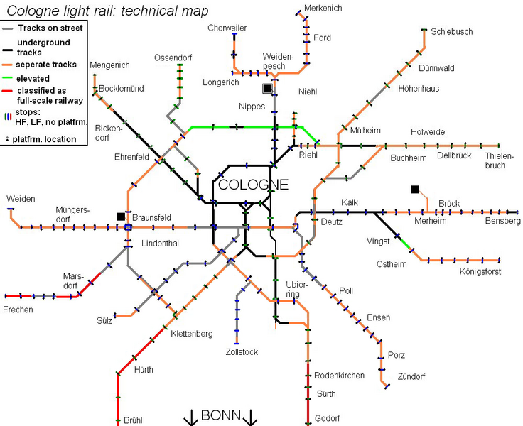
Technical map of the light rail system of
Cologne (2017)
289:
Add a one-line explanation of what this file represents
129:
109:
Commons is a freely licensed media file repository.
75:(1,000 × 815 pixels, file size: 312 KB, MIME type:
258:https://creativecommons.org/licenses/by-sa/4.0
90:
264:Creative Commons Attribution-Share Alike 4.0
188:
8:
224:– to copy, distribute and transmit the work
530:
432:
285:
505:The following other wikis use this file:
211:Attribution-Share Alike 4.0 International
540:
532:
492:
408:
392:
372:
356:
336:
320:
303:
300:
281:
274:
7:
490:The following page uses this file:
480:User created page with UploadWizard
421:
199:
194:
523:
294:
288:
185:
139:
122:
68:
293:
279:
235:Under the following conditions:
206:This file is licensed under the
198:
193:
187:
89:
31:
21:
276:
140:
14:
275:
26:
1:
36:
301:Items portrayed in this file
562:
509:Usage on eo.wikipedia.org
249:same or compatible license
422:
16:
278:
215:
96:This is a file from the
479:
170:
160:
153:
150:
132:
100:. Information from its
103:description page there
46:Size of this preview:
534:Horizontal resolution
513:Stadtbahn de Kolonjo
458:21:23, 15 March 2017
542:Vertical resolution
230:– to adapt the work
174:Philld1991, Mikosch
52:Other resolutions:
135:Technical map2.png
62:1,000 × 815 pixels
549:
548:
501:Global file usage
495:Cologne Stadtbahn
483:
359:copyright license
287:
178:
177:
118:
117:
98:Wikimedia Commons
32:Global file usage
553:
531:
470:
323:copyright status
271:
268:
265:
262:
259:
251:as the original.
208:Creative Commons
202:
201:
197:
196:
191:
190:
156:
144:
136:
130:
114:
93:
92:
86:
80:
78:
65:
58:589 × 480 pixels
54:295 × 240 pixels
48:736 × 600 pixels
561:
560:
556:
555:
554:
552:
551:
550:
519:
499:
484:
476:
468:
424:
423:
420:
419:
418:
417:
416:
415:
414:
413:
411:
401:
400:
399:
397:
386:
385:
384:
383:
382:
381:
380:
379:
377:
365:
364:
363:
361:
350:
349:
348:
347:
346:
345:
344:
343:
341:
329:
328:
327:
325:
314:
313:
312:
311:
310:
308:
292:
291:
290:
273:
272:
269:
266:
263:
260:
257:
256:
214:
203:
184:
179:
146:
134:
127:
120:
119:
108:
107:
106:is shown below.
82:
76:
74:
67:
66:
51:
12:
11:
5:
559:
557:
547:
546:
543:
539:
538:
535:
522:
518:
517:
516:
515:
503:
502:
498:
497:
488:
487:
482:
481:
478:
474:
471:
465:
460:
455:
451:
450:
447:
444:
441:
438:
435:
428:
427:
412:
409:
407:
406:
405:
404:
403:
402:
398:
393:
391:
390:
389:
388:
387:
378:
373:
371:
370:
369:
368:
367:
366:
362:
357:
355:
354:
353:
352:
351:
342:
337:
335:
334:
333:
332:
331:
330:
326:
321:
319:
318:
317:
316:
315:
309:
304:
302:
299:
298:
297:
296:
295:
284:
283:
280:
277:
255:
254:
253:
252:
242:
233:
232:
231:
225:
218:You are free:
205:
204:
186:
183:
180:
176:
175:
172:
168:
167:
162:
158:
157:
152:
148:
147:
137:
128:
126:
123:
121:
116:
115:
94:
84:
83:
45:
41:
40:
39:
34:
29:
24:
19:
13:
10:
9:
6:
4:
3:
2:
558:
544:
541:
536:
533:
529:
526:
520:
514:
511:
510:
508:
507:
506:
500:
496:
493:
491:
485:
477:
472:
466:
464:
461:
459:
456:
453:
452:
448:
445:
442:
439:
436:
434:
433:
431:
425:
410:14 March 2017
396:
376:
360:
340:
324:
307:
261:CC BY-SA 4.0
250:
246:
243:
240:
237:
236:
234:
229:
226:
223:
220:
219:
217:
216:
212:
209:
192:
181:
173:
169:
166:
163:
159:
155:14 March 2017
149:
143:
138:
131:
124:
112:
105:
104:
99:
95:
88:
87:
81:
72:
71:Original file
63:
59:
55:
49:
44:
38:
35:
33:
30:
28:
25:
23:
20:
18:
15:
527:
524:
504:
489:
467:1,000 × 815
429:
426:File history
244:
238:
227:
221:
141:
111:You can help
101:
69:
22:File history
339:copyrighted
245:share alike
239:attribution
133:Description
486:File usage
475:Philld1991
443:Dimensions
27:File usage
545:28.35 dpc
537:28.35 dpc
440:Thumbnail
437:Date/Time
395:inception
182:Licensing
142:English:
77:image/png
521:Metadata
469:(312 KB)
282:Captions
228:to remix
222:to share
213:license.
37:Metadata
454:current
449:Comment
306:depicts
286:English
125:Summary
73:
171:Author
161:Source
446:User
270:true
267:true
151:Date
17:File
60:|
56:|
50:.
113:.
79:)
64:.
Text is available under the Creative Commons Attribution-ShareAlike License. Additional terms may apply.
