340:
273:
223:
265:
215:
287:
237:
308:
346:
351:
67:
646:"}},"text\/plain":{"en":{"":"heading"}}},"{\"value\":{\"amount\":\"+0\",\"unit\":\"http:\\\/\\\/www.wikidata.org\\\/entity\\\/Q28390\"},\"type\":\"quantity\"}":{"text\/html":{"en":{"P7787":"0
582:"}},"text\/plain":{"en":{"":"heading"}}},"{\"value\":{\"amount\":\"+0\",\"unit\":\"http:\\\/\\\/www.wikidata.org\\\/entity\\\/Q28390\"},\"type\":\"quantity\"}":{"text\/html":{"en":{"P7787":"0
642:
782:
206:
398:– You must give appropriate credit, provide a link to the license, and indicate if changes were made. You may do so in any reasonable manner, but not in any way that suggests the licensor endorses you or your use.
446:
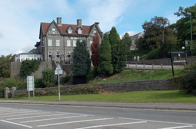
The Ambala Indian restaurant, bar and hotel is located between
Station Road (A4046) and Dyffryn Road (B4486). The Ambala opened in August 2013. The building was previously the Park Hotel.
121:
The Ambala Indian restaurant, bar and hotel is located between
Station Road (A4046) and Dyffryn Road (B4486). The Ambala opened in August 2013. The building was previously the Park Hotel.
38:
643:
579:
531:
495:
280:
230:
315:
78:
46:
405:
713:
684:
657:
620:
593:
479:
551:
515:
462:
302:
361:
404:– If you remix, transform, or build upon the material, you must distribute your contributions under the
322:
on the
Geograph website for the photographer's contact details. The copyright on this image is owned by
358:
650:"}},"text\/plain":{"en":{"P7787":"0 degree"}}}}": -->
586:"}},"text\/plain":{"en":{"P7787":"0 degree"}}}}": -->
86:
175:
781:
776:
37:
159:
286:
236:
792:
327:
73:
130:
270:
220:
861:
813:
140:
307:
319:
749:
Click on a date/time to view the file as it appeared at that time.
272:
222:
247:
197:
61:
207:
51° 45′ 19.4″ N, 3° 11′ 40″ W
257:
51° 45′ 21″ N, 3° 11′ 40″ W
871:
841:
831:
851:
105:
85:
Commons is a freely licensed media file repository.
532:
Creative
Commons Attribution-ShareAlike 2.0 Generic
51:(800 × 528 pixels, file size: 115 KB, MIME type:
415:https://creativecommons.org/licenses/by-sa/2.0
66:
421:Creative Commons Attribution-Share Alike 2.0
339:
8:
647:
583:
381:– to copy, distribute and transmit the work
751:
442:
824:The following other wikis use this file:
141:https://www.geograph.org.uk/photo/3666058
811:
727:
711:
671:
655:
607:
591:
565:
549:
529:
513:
493:
477:
460:
457:
438:
431:
250:
200:
279:View this and other nearby images on:
229:View this and other nearby images on:
7:
326:and is licensed for reuse under the
809:The following page uses this file:
799:User created page with UploadWizard
740:
362:Attribution-Share Alike 2.0 Generic
350:
345:
330:Attribution-ShareAlike 2.0 license.
451:
445:
336:
313:
115:
98:
44:
450:
862:Wikipedysta:ZAJCOPEDIA/Waun-Lwyd
594:coordinates of the point of view
436:
392:Under the following conditions:
357:This file is licensed under the
349:
344:
338:
306:
285:
271:
263:
235:
221:
213:
65:
31:
21:
433:
116:
41:No higher resolution available.
14:
432:
314:This image was taken from the
26:
1:
658:coordinates of depicted place
458:Items portrayed in this file
673:51°45'21.02"N, 3°11'39.84"W
609:51°45'19.40"N, 3°11'39.84"W
890:
868:Usage on www.wikidata.org
858:Usage on pl.wikipedia.org
848:Usage on eu.wikipedia.org
838:Usage on es.wikipedia.org
828:Usage on cy.wikipedia.org
406:same or compatible license
262:
212:
741:
16:
435:
372:
111:The Ambala, Waunlwyd.jpg
72:This is a file from the
47:The_Ambala,_Waunlwyd.jpg
798:
160:required by the license
146:
136:
129:
126:
108:
76:. Information from its
320:this photograph's page
291:51.755840; -3.194400
241:51.755390; -3.194400
79:description page there
777:16:07, 6 October 2019
190:The Ambala, Waunlwyd
188:Jaggery /
171:The Ambala, Waunlwyd
169:Jaggery /
387:– to adapt the work
820:Global file usage
802:
649:
585:
567:23 September 2013
516:copyright license
444:
335:
334:
318:collection. See
296:
295:
246:
245:
195:
194:
163:
131:23 September 2013
94:
93:
74:Wikimedia Commons
32:Global file usage
881:
789:
695:
694:
689:
631:
630:
625:
480:copyright status
428:
425:
422:
419:
416:
408:as the original.
370:
359:Creative Commons
353:
352:
348:
347:
342:
341:
328:Creative Commons
316:Geograph project
310:
303:
292:
289:
275:
274:
268:
267:
266:
260:
259:
248:
242:
239:
225:
224:
218:
217:
216:
210:
209:
198:
157:
132:
120:
112:
106:
90:
69:
68:
62:
56:
54:
889:
888:
884:
883:
882:
880:
879:
878:
818:
803:
795:
787:
743:
742:
739:
738:
737:
736:
735:
734:
733:
732:
730:
720:
719:
718:
716:
705:
704:
703:
702:
701:
700:
699:
698:
697:
696:
692:
690:
687:
678:
677:
676:
674:
664:
663:
662:
660:
641:
640:
639:
638:
637:
636:
635:
634:
633:
632:
628:
626:
623:
614:
613:
612:
610:
600:
599:
598:
596:
577:
576:
575:
574:
573:
572:
571:
570:
568:
558:
557:
556:
554:
543:
542:
541:
540:
539:
538:
537:
536:
534:
522:
521:
520:
518:
507:
506:
505:
504:
503:
502:
501:
500:
498:
486:
485:
484:
482:
471:
470:
469:
468:
467:
465:
449:
448:
447:
430:
429:
426:
423:
420:
417:
414:
413:
371:
368:
365:
354:
331:
301:
290:
264:
255:
254:
251:Object location
240:
214:
205:
204:
201:Camera location
196:
185:
178:
166:
122:
110:
103:
96:
95:
84:
83:
82:is shown below.
58:
52:
50:
43:
42:
12:
11:
5:
887:
885:
877:
876:
875:
874:
866:
865:
864:
856:
855:
854:
846:
845:
844:
836:
835:
834:
822:
821:
817:
816:
807:
806:
801:
800:
797:
793:
790:
784:
779:
774:
770:
769:
766:
763:
760:
757:
754:
747:
746:
731:
728:
726:
725:
724:
723:
722:
721:
717:
712:
710:
709:
708:
707:
706:
683:
682:
681:
680:
679:
675:
672:
670:
669:
668:
667:
666:
665:
661:
656:
654:
653:
652:
651:
645:
619:
618:
617:
616:
615:
611:
608:
606:
605:
604:
603:
602:
601:
597:
592:
590:
589:
588:
587:
581:
569:
566:
564:
563:
562:
561:
560:
559:
555:
550:
548:
547:
546:
545:
544:
535:
530:
528:
527:
526:
525:
524:
523:
519:
514:
512:
511:
510:
509:
508:
499:
494:
492:
491:
490:
489:
488:
487:
483:
478:
476:
475:
474:
473:
472:
466:
461:
459:
456:
455:
454:
453:
452:
441:
440:
437:
434:
412:
411:
410:
409:
399:
390:
389:
388:
382:
375:You are free:
366:
356:
355:
337:
333:
332:
311:
300:
297:
294:
293:
283:
277:
252:
244:
243:
233:
227:
202:
193:
192:
186:
183:
180:
179:
174:
167:
164:
152:
151:
148:
144:
143:
138:
134:
133:
128:
124:
123:
113:
104:
102:
99:
97:
92:
91:
70:
60:
59:
40:
36:
35:
34:
29:
24:
19:
13:
10:
9:
6:
4:
3:
2:
886:
873:
870:
869:
867:
863:
860:
859:
857:
853:
850:
849:
847:
843:
840:
839:
837:
833:
830:
829:
827:
826:
825:
819:
815:
812:
810:
804:
796:
791:
785:
783:
780:
778:
775:
772:
771:
767:
764:
761:
758:
755:
753:
752:
750:
744:
715:
686:
659:
622:
595:
553:
533:
517:
497:
481:
464:
418:CC BY-SA 2.0
407:
403:
400:
397:
394:
393:
391:
386:
383:
380:
377:
376:
374:
373:
367:Attribution:
363:
360:
343:
329:
325:
321:
317:
312:
309:
305:
304:
298:
288:
284:
282:
281:OpenStreetMap
278:
276:
258:
253:
249:
238:
234:
232:
231:OpenStreetMap
228:
226:
208:
203:
199:
191:
187:
182:
181:
177:
173: /
172:
168:
161:
156:
154:
153:
149:
145:
142:
139:
135:
125:
119:
114:
107:
100:
88:
81:
80:
75:
71:
64:
63:
57:
48:
39:
33:
30:
28:
25:
23:
20:
18:
15:
823:
808:
748:
745:File history
401:
395:
384:
378:
323:
261:
211:
189:
176:CC BY-SA 2.0
170:
117:
87:You can help
77:
45:
22:File history
496:copyrighted
402:share alike
396:attribution
155:Attribution
109:Description
805:File usage
786:800 × 528
762:Dimensions
729:image/jpeg
714:media type
53:image/jpeg
27:File usage
872:Q20602262
842:Waun-Lwyd
832:Waun-lwyd
814:Waun-Lwyd
759:Thumbnail
756:Date/Time
552:inception
299:Licensing
184:InfoField
165:InfoField
118:English:
852:Waunlwyd
794:Llemiles
788:(115 KB)
439:Captions
385:to remix
379:to share
364:license.
773:current
768:Comment
685:heading
644:heading
621:heading
580:heading
463:depicts
443:English
369:Jaggery
324:Jaggery
150:Jaggery
101:Summary
49:
693:degree
648:degree
629:degree
584:degree
269:
219:
147:Author
137:Source
765:User
427:true
424:true
127:Date
17:File
691:0
688::
627:0
624::
162:)
158:(
89:.
55:)
Text is available under the Creative Commons Attribution-ShareAlike License. Additional terms may apply.
_region:GB-EAW_heading:0.00&language=en)
_region:GB-EAW_heading:0.00&language=en)
