380:
313:
263:
305:
255:
327:
277:
348:
386:
391:
72:
856:"}},"text\/plain":{"en":{"":"heading"}}},"{\"value\":{\"amount\":\"+135\",\"unit\":\"http:\\\/\\\/www.wikidata.org\\\/entity\\\/Q28390\"},\"type\":\"quantity\"}":{"text\/html":{"en":{"P7787":"135
792:"}},"text\/plain":{"en":{"":"heading"}}},"{\"value\":{\"amount\":\"+135\",\"unit\":\"http:\\\/\\\/www.wikidata.org\\\/entity\\\/Q28390\"},\"type\":\"quantity\"}":{"text\/html":{"en":{"P7787":"135
852:
296:
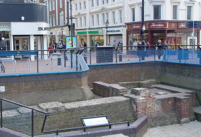
975:== {{int:filedesc}} == {{Information |description={{en|1=The Beverley Gate The old town of Hull was protected by a fortified wall, part of which is seen here. The walls were taken down and used for lining the docks when their defensive value was reduced
246:
139:
This site, the
Beverley Gate, is the position where (in April 1642) the governor of Hull, Sir John Hotham denied King Charles access to town (and hence to the arsenal of weapons), this being one of the acts which precipitated the English civil war.
43:
438:– You must give appropriate credit, provide a link to the license, and indicate if changes were made. You may do so in any reasonable manner, but not in any way that suggests the licensor endorses you or your use.
136:
The old town of Hull was protected by a fortified wall, part of which is seen here. The walls were taken down and used for lining the docks when their defensive value was reduced by the invention of gunpowder.
83:
51:
853:
789:
994:
989:
183:
690:
654:
618:
320:
270:
725:
355:
1025:
This file contains additional information, probably added from the digital camera or scanner used to create or digitize it.
445:
142:
Beyond the site the streets are left Alfred Gelder Street, straight on to
Whitefriargate, and right to Princes Dock Street.
581:
894:
867:
830:
803:
703:
674:
602:
574:
559:
546:
761:
733:
718:
638:
519:
502:
957:
952:
342:
131:
42:
401:
1028:
If the file has been modified from its original state, some details may not fully reflect the modified file.
985:
The following pages on the
English Knowledge (XXG) use this file (pages on other projects are not listed):
444:– If you remix, transform, or build upon the material, you must distribute your contributions under the
362:
on the
Geograph website for the photographer's contact details. The copyright on this image is owned by
968:
398:
860:"}},"text\/plain":{"en":{"P7787":"135 degree"}}}}": -->
796:"}},"text\/plain":{"en":{"P7787":"135 degree"}}}}": -->
127:
91:
215:
566:
740:
710:
199:
326:
276:
367:
78:
310:
151:
260:
172:
162:
347:
1012:
359:
925:
Click on a date/time to view the file as it appeared at that time.
312:
262:
287:
237:
66:
297:
53° 44′ 36.3″ N, 0° 20′ 16.5″ W
247:
53° 44′ 36.6″ N, 0° 20′ 17.2″ W
486:
Add a one-line explanation of what this file represents
190:
Creative
Commons Attribution Share-alike license 2.0
110:
90:
Commons is a freely licensed media file repository.
655:
Creative
Commons Attribution-ShareAlike 2.0 Generic
116:The Beverley Gate - geograph.org.uk - 624987.jpg
56:(640 × 436 pixels, file size: 93 KB, MIME type:
52:The_Beverley_Gate_-_geograph.org.uk_-_624987.jpg
455:https://creativecommons.org/licenses/by-sa/2.0
71:
461:Creative Commons Attribution-Share Alike 2.0
379:
8:
857:
793:
421:– to copy, distribute and transmit the work
1030:
927:
482:
1005:The following other wikis use this file:
567:https://www.geograph.org.uk/profile/16649
741:https://www.geograph.org.uk/photo/624987
1032:
995:List of town walls in England and Wales
987:
881:
865:
817:
801:
775:
759:
688:
672:
652:
636:
616:
600:
533:
517:
500:
497:
478:
471:
290:
240:
319:View this and other nearby images on:
269:View this and other nearby images on:
7:
366:and is licensed for reuse under the
990:List of cities with defensive walls
916:
402:Attribution-Share Alike 2.0 Generic
390:
385:
370:Attribution-ShareAlike 2.0 license.
1023:
491:
485:
376:
353:
120:
103:
49:
490:
804:coordinates of the point of view
476:
432:Under the following conditions:
397:This file is licensed under the
389:
384:
378:
346:
325:
311:
303:
275:
261:
253:
70:
31:
21:
473:
121:
46:No higher resolution available.
14:
691:file available on the internet
472:
354:This image was taken from the
26:
1:
883:53°44'36.301"N, 0°20'16.512"W
868:coordinates of depicted place
36:
726:Geograph Britain and Ireland
575:object of statement has role
498:Items portrayed in this file
302:
252:
819:53°44'36.60"N, 0°20'17.23"W
1054:
1009:Usage on da.wikipedia.org
446:same or compatible license
1013:Bymure i England og Wales
917:
228:Peter Church /
209:Peter Church /
16:
704:geograph.org.uk image ID
475:
412:
132:East Riding of Yorkshire
77:This is a file from the
974:
200:required by the license
178:
168:
157:
150:
147:
113:
81:. Information from its
953:07:09, 7 February 2011
360:this photograph's page
331:53.743417; -0.337920
281:53.743500; -0.338120
84:description page there
427:– to adapt the work
126:The Beverley Gate,
547:author name string
1041:
1040:
1001:Global file usage
978:
859:
795:
639:copyright license
484:
375:
374:
358:collection. See
336:
335:
286:
285:
235:
234:
230:The Beverley Gate
211:The Beverley Gate
203:
187:
184:Reusing this file
99:
98:
79:Wikimedia Commons
32:Global file usage
1045:
1031:
965:
905:
904:
899:
841:
840:
835:
743:
738:
734:described at URL
728:
723:
713:
708:
603:copyright status
584:
579:
569:
564:
554:
551:
468:
465:
462:
459:
456:
448:as the original.
410:
399:Creative Commons
393:
392:
388:
387:
382:
381:
368:Creative Commons
356:Geograph project
350:
343:
332:
329:
315:
314:
308:
307:
306:
300:
299:
288:
282:
279:
265:
264:
258:
257:
256:
250:
249:
238:
197:
181:
153:
125:
117:
111:
95:
74:
73:
67:
61:
59:
1053:
1052:
1048:
1047:
1046:
1044:
1043:
1042:
1019:
999:
986:
979:
971:
963:
919:
918:
915:
914:
913:
912:
911:
910:
909:
908:
907:
906:
902:
900:
897:
888:
887:
886:
884:
874:
873:
872:
870:
851:
850:
849:
848:
847:
846:
845:
844:
843:
842:
838:
836:
833:
824:
823:
822:
820:
810:
809:
808:
806:
787:
786:
785:
784:
783:
782:
781:
780:
778:
777:4 November 2007
768:
767:
766:
764:
753:
752:
751:
750:
749:
748:
747:
746:
745:
744:
739:
736:
730:
729:
724:
721:
715:
714:
709:
706:
697:
696:
695:
693:
681:
680:
679:
677:
666:
665:
664:
663:
662:
661:
660:
659:
657:
645:
644:
643:
641:
630:
629:
628:
627:
626:
625:
624:
623:
621:
609:
608:
607:
605:
594:
593:
592:
591:
590:
589:
588:
587:
586:
585:
580:
577:
571:
570:
565:
562:
556:
555:
552:
549:
540:
539:
538:
536:
526:
525:
524:
522:
511:
510:
509:
508:
507:
505:
489:
488:
487:
470:
469:
466:
463:
460:
457:
454:
453:
411:
408:
405:
394:
371:
341:
330:
304:
295:
294:
291:Object location
280:
254:
245:
244:
241:Camera location
236:
225:
218:
206:
163:geograph.org.uk
152:4 November 2007
143:
115:
108:
101:
100:
89:
88:
87:is shown below.
63:
57:
55:
48:
47:
12:
11:
5:
1051:
1049:
1039:
1038:
1035:
1022:
1018:
1017:
1016:
1015:
1003:
1002:
998:
997:
992:
984:
983:
982:
977:
976:
973:
969:
966:
960:
955:
950:
946:
945:
942:
939:
936:
933:
930:
923:
922:
893:
892:
891:
890:
889:
885:
882:
880:
879:
878:
877:
876:
875:
871:
866:
864:
863:
862:
861:
855:
829:
828:
827:
826:
825:
821:
818:
816:
815:
814:
813:
812:
811:
807:
802:
800:
799:
798:
797:
791:
779:
776:
774:
773:
772:
771:
770:
769:
765:
760:
758:
757:
756:
755:
754:
732:
731:
717:
716:
702:
701:
700:
699:
698:
694:
689:
687:
686:
685:
684:
683:
682:
678:
675:source of file
673:
671:
670:
669:
668:
667:
658:
653:
651:
650:
649:
648:
647:
646:
642:
637:
635:
634:
633:
632:
631:
622:
617:
615:
614:
613:
612:
611:
610:
606:
601:
599:
598:
597:
596:
595:
573:
572:
558:
557:
545:
544:
543:
542:
541:
537:
534:
532:
531:
530:
529:
528:
527:
523:
518:
516:
515:
514:
513:
512:
506:
501:
499:
496:
495:
494:
493:
492:
481:
480:
477:
474:
452:
451:
450:
449:
439:
430:
429:
428:
422:
415:You are free:
406:
396:
395:
377:
373:
372:
351:
340:
337:
334:
333:
323:
317:
292:
284:
283:
273:
267:
242:
233:
232:
226:
223:
220:
219:
214:
207:
204:
192:
191:
188:
176:
175:
170:
166:
165:
159:
155:
154:
149:
145:
144:
118:
109:
107:
104:
102:
97:
96:
75:
65:
64:
45:
41:
40:
39:
34:
29:
24:
19:
13:
10:
9:
6:
4:
3:
2:
1050:
1036:
1033:
1029:
1026:
1020:
1014:
1011:
1010:
1008:
1007:
1006:
1000:
996:
993:
991:
988:
980:
972:
967:
961:
959:
956:
954:
951:
948:
947:
943:
940:
937:
934:
931:
929:
928:
926:
920:
896:
869:
832:
805:
763:
742:
735:
727:
720:
712:
705:
692:
676:
656:
640:
620:
604:
583:
576:
568:
561:
548:
521:
504:
458:CC BY-SA 2.0
447:
443:
440:
437:
434:
433:
431:
426:
423:
420:
417:
416:
414:
413:
407:Attribution:
403:
400:
383:
369:
365:
361:
357:
352:
349:
345:
344:
338:
328:
324:
322:
321:OpenStreetMap
318:
316:
298:
293:
289:
278:
274:
272:
271:OpenStreetMap
268:
266:
248:
243:
239:
231:
227:
222:
221:
217:
213: /
212:
208:
201:
196:
194:
193:
189:
185:
180:
177:
174:
171:
167:
164:
160:
156:
146:
141:
135:
133:
129:
124:
119:
112:
105:
93:
86:
85:
80:
76:
69:
68:
62:
53:
44:
38:
35:
33:
30:
28:
25:
23:
20:
18:
15:
1027:
1024:
1004:
924:
921:File history
582:photographer
553:Peter Church
441:
435:
424:
418:
409:Peter Church
364:Peter Church
363:
301:
251:
229:
216:CC BY-SA 2.0
210:
173:Peter Church
138:
122:
92:You can help
82:
50:
22:File history
970:GeographBot
619:copyrighted
442:share alike
436:attribution
195:Attribution
114:Description
1034:_error
981:File usage
962:640 × 436
938:Dimensions
535:some value
179:Permission
134:, England.
58:image/jpeg
27:File usage
935:Thumbnail
932:Date/Time
762:inception
339:Licensing
224:InfoField
205:InfoField
123:English:
1021:Metadata
719:operator
479:Captions
425:to remix
419:to share
404:license.
37:Metadata
964:(93 KB)
949:current
944:Comment
895:heading
854:heading
831:heading
790:heading
520:creator
503:depicts
483:English
106:Summary
54:
903:degree
858:degree
839:degree
794:degree
711:624987
309:
259:
169:Author
158:Source
161:From
941:User
901:135
837:135
467:true
464:true
148:Date
128:Hull
17:File
560:URL
898::
834::
737::
722::
707::
578::
563::
550::
130:,
1037:0
202:)
198:(
186:)
182:(
94:.
60:)
Text is available under the Creative Commons Attribution-ShareAlike License. Additional terms may apply.
_heading:135.00&language=en)
_heading:135.00&language=en)
