43:
371:
304:
254:
296:
246:
318:
268:
339:
377:
382:
103:
847:"}},"text\/plain":{"en":{"":"heading"}}},"{\"value\":{\"amount\":\"+202\",\"unit\":\"http:\\\/\\\/www.wikidata.org\\\/entity\\\/Q28390\"},\"type\":\"quantity\"}":{"text\/html":{"en":{"P7787":"202
783:"}},"text\/plain":{"en":{"":"heading"}}},"{\"value\":{\"amount\":\"+202\",\"unit\":\"http:\\\/\\\/www.wikidata.org\\\/entity\\\/Q28390\"},\"type\":\"quantity\"}":{"text\/html":{"en":{"P7787":"202
1161:
843:
237:
69:
65:
61:
57:
53:
47:
114:
82:
429:– You must give appropriate credit, provide a link to the license, and indicate if changes were made. You may do so in any reasonable manner, but not in any way that suggests the licensor endorses you or your use.
1178:== {{int:filedesc}} == {{Information |Description={{en|1=The Former Railway Station, Framlingham, near to Framlingham, Suffolk, Great Britain. }} |Source=From ; transferred by
844:
780:
1160:
1155:
73:
42:
215:
1205:
715:
645:
609:
311:
261:
1352:
735:
1383:
346:
1246:
This file contains additional information, probably added from the digital camera or scanner used to create or digitize it.
1106:
436:
1171:
572:
1056:
1022:
985:
951:
914:
885:
858:
821:
794:
743:
699:
593:
565:
550:
537:
1200:
758:
728:
665:
629:
510:
493:
1090:
333:
392:
1249:
If the file has been modified from its original state, some details may not fully reflect the modified file.
1191:
The following pages on the
English Knowledge (XXG) use this file (pages on other projects are not listed):
1436:
435:– If you remix, transform, or build upon the material, you must distribute your contributions under the
353:
on the
Geograph website for the photographer's contact details. The copyright on this image is owned by
389:
851:"}},"text\/plain":{"en":{"P7787":"202 degree"}}}}": -->
787:"}},"text\/plain":{"en":{"P7787":"202 degree"}}}}": -->
1472:
1268:
1195:
122:
1179:
765:
750:
557:
317:
267:
1540:
1454:
1410:
1275:
358:
189:
109:
1315:
158:
1482:
174:
1295:
301:
251:
1223:
185:
204:
1558:
1285:
1258:
338:
147:
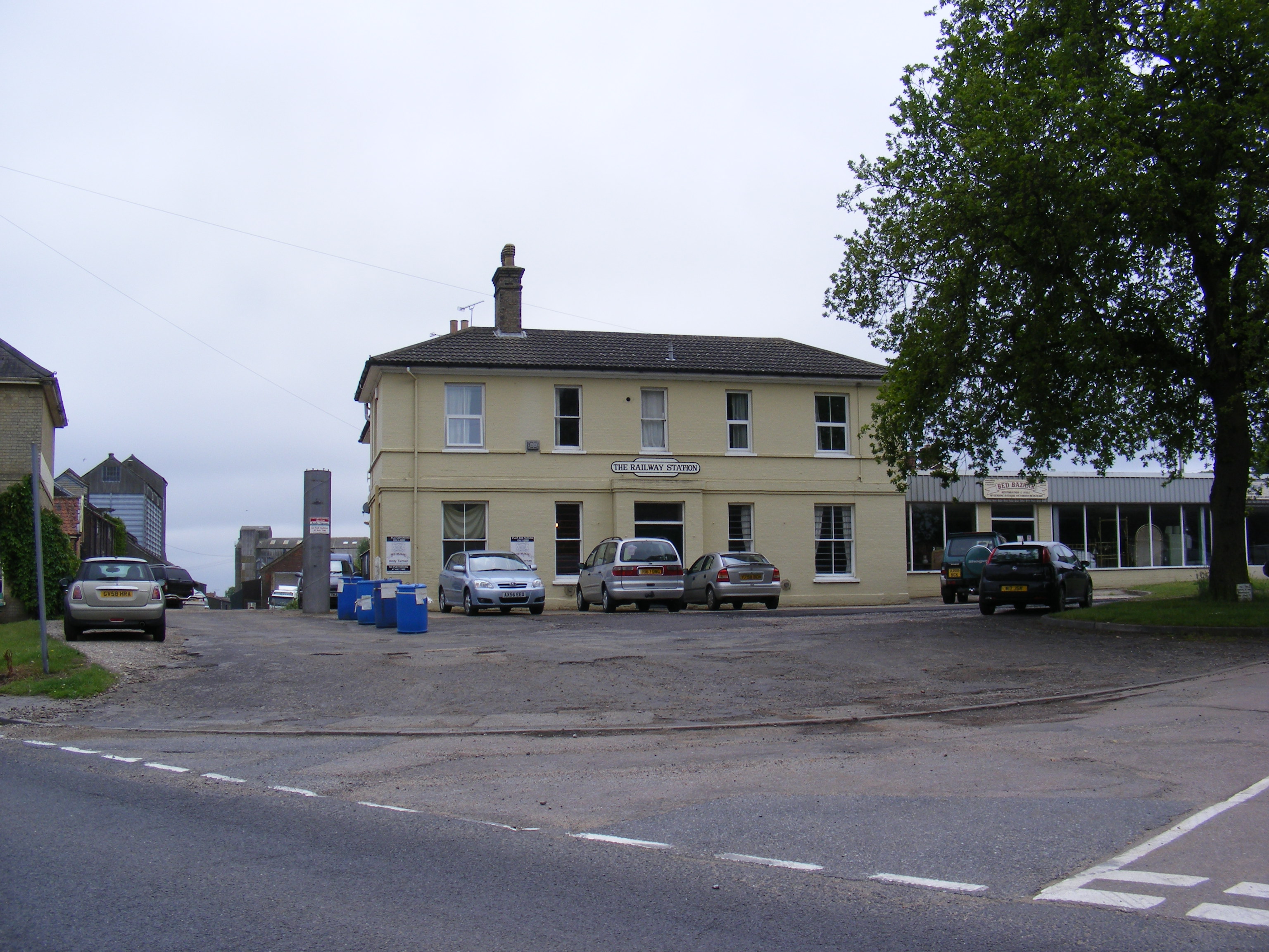
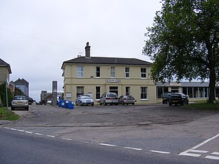
The Former
Railway Station, Framlingham - geograph.org.uk - 1909559.jpg
350:
1128:
Click on a date/time to view the file as it appeared at that time.
162:
303:
253:
193:
278:
228:
97:
288:
52° 13′ 06.6″ N, 1° 20′ 34″ E
238:
52° 13′ 07.8″ N, 1° 20′ 35″ E
477:
Add a one-line explanation of what this file represents
87:(3,072 × 2,304 pixels, file size: 1.35 MB, MIME type:
1233:
222:
Creative
Commons Attribution Share-alike license 2.0
141:
121:
Commons is a freely licensed media file repository.
646:
Creative
Commons Attribution-ShareAlike 2.0 Generic
1477:Flash did not fire, compulsory flash suppression
446:https://creativecommons.org/licenses/by-sa/2.0
102:
452:Creative Commons Attribution-Share Alike 2.0
370:
8:
848:
784:
412:– to copy, distribute and transmit the work
1251:
1130:
473:
1353:Digital Camera FinePix S5700 S700 Ver1.02
1216:The following other wikis use this file:
766:https://www.geograph.org.uk/photo/1909559
558:https://www.geograph.org.uk/profile/2639
1566:
1556:
1548:
1538:
1530:
1522:
1514:
1506:
1498:
1490:
1480:
1470:
1462:
1452:
1444:
1434:
1426:
1418:
1408:
1400:
1392:
1381:
1373:
1365:
1357:
1347:
1339:
1331:
1323:
1312:
1304:
1293:
1283:
1273:
1263:
1193:
1104:
1088:
1070:
1054:
1036:
1020:
999:
983:
965:
949:
928:
912:
872:
856:
808:
792:
713:
697:
679:
663:
643:
627:
607:
591:
524:
508:
491:
488:
469:
462:
281:
231:
310:View this and other nearby images on:
260:View this and other nearby images on:
1253:
7:
357:and is licensed for reuse under the
1119:
393:Attribution-Share Alike 2.0 Generic
381:
376:
361:Attribution-ShareAlike 2.0 license.
1244:
482:
476:
367:
344:
151:
134:
80:
481:
1306:Date and time of data generation
1206:History of the East Suffolk line
795:coordinates of the point of view
467:
423:Under the following conditions:
388:This file is licensed under the
380:
375:
369:
337:
316:
302:
294:
266:
252:
244:
101:
31:
21:
1173:File Upload Bot (Magnus Manske)
464:
152:
14:
1280:1/280 sec (0.0035714285714286)
1220:Usage on simple.wikipedia.org
716:file available on the internet
463:
345:This image was taken from the
26:
1:
859:coordinates of depicted place
36:
736:Geograph Britain and Ireland
566:object of statement has role
489:Items portrayed in this file
293:
243:
157:The former railway station,
1508:Focal plane resolution unit
1394:Date and time of digitizing
1224:Framlingham railway station
1201:Framlingham railway station
1588:
1519:One-chip color area sensor
1230:Usage on www.wikidata.org
874:52°13'6.56"N, 1°20'34.44"E
810:52°13'7.82"N, 1°20'35.16"E
437:same or compatible license
1359:File change date and time
1120:
16:
1500:Focal plane Y resolution
1492:Focal plane X resolution
744:geograph.org.uk image ID
466:
403:
108:This is a file from the
1524:Custom image processing
1177:
930:0.00357142857142857142
210:
200:
180:
173:
170:
144:
112:. Information from its
1568:Subject distance range
1402:Image compression mode
351:this photograph's page
322:52.218490; 1.342900
272:52.218840; 1.343100
115:description page there
46:Size of this preview:
1446:Maximum land aperture
1333:Horizontal resolution
194:geograph_org2commons
74:3,072 × 2,304 pixels
70:2,560 × 1,920 pixels
1397:13:53, 11 June 2010
1367:Y and C positioning
1362:13:53, 11 June 2010
1341:Vertical resolution
1309:13:53, 11 June 2010
1255:Camera manufacturer
1156:12:05, 23 July 2010
418:– to adapt the work
52:Other resolutions:
1550:Scene capture type
1545:Auto white balance
1269:FinePix S5700 S700
1196:Framlingham branch
538:author name string
66:1,280 × 960 pixels
62:1,024 × 768 pixels
1575:
1574:
1449:3.6 APEX (f/3.48)
1212:Global file usage
1184:
850:
786:
630:copyright license
475:
366:
365:
349:collection. See
327:
326:
277:
276:
226:
225:
219:
216:Reusing this file
188:; transferred by
130:
129:
110:Wikimedia Commons
32:Global file usage
1579:
1375:Exposure Program
1252:
1180:User:Rubberstamp
1168:
1004:
933:
896:
895:
890:
832:
831:
826:
768:
763:
759:described at URL
753:
748:
738:
733:
594:copyright status
575:
570:
560:
555:
545:
542:
459:
456:
453:
450:
447:
439:as the original.
401:
390:Creative Commons
384:
383:
379:
378:
373:
372:
359:Creative Commons
347:Geograph project
341:
334:
323:
320:
306:
305:
299:
298:
297:
291:
290:
279:
273:
270:
256:
255:
249:
248:
247:
241:
240:
229:
213:
190:User:Rubberstamp
176:
156:
148:
142:
126:
105:
104:
98:
92:
90:
77:
58:640 × 480 pixels
54:320 × 240 pixels
48:800 × 600 pixels
1587:
1586:
1582:
1581:
1580:
1578:
1577:
1576:
1428:APEX brightness
1240:
1210:
1192:
1185:
1174:
1166:
1122:
1121:
1118:
1117:
1116:
1115:
1114:
1113:
1112:
1111:
1109:
1097:
1096:
1095:
1093:
1082:
1081:
1080:
1079:
1078:
1077:
1076:
1075:
1073:
1063:
1062:
1061:
1059:
1048:
1047:
1046:
1045:
1044:
1043:
1042:
1041:
1039:
1029:
1028:
1027:
1025:
1014:
1013:
1012:
1011:
1010:
1009:
1008:
1007:
1005:
1002:
992:
991:
990:
988:
977:
976:
975:
974:
973:
972:
971:
970:
968:
958:
957:
956:
954:
943:
942:
941:
940:
939:
938:
937:
936:
934:
931:
921:
920:
919:
917:
906:
905:
904:
903:
902:
901:
900:
899:
898:
897:
893:
891:
888:
879:
878:
877:
875:
865:
864:
863:
861:
842:
841:
840:
839:
838:
837:
836:
835:
834:
833:
829:
827:
824:
815:
814:
813:
811:
801:
800:
799:
797:
778:
777:
776:
775:
774:
773:
772:
771:
770:
769:
764:
761:
755:
754:
749:
746:
740:
739:
734:
731:
722:
721:
720:
718:
706:
705:
704:
702:
691:
690:
689:
688:
687:
686:
685:
684:
682:
672:
671:
670:
668:
657:
656:
655:
654:
653:
652:
651:
650:
648:
636:
635:
634:
632:
621:
620:
619:
618:
617:
616:
615:
614:
612:
600:
599:
598:
596:
585:
584:
583:
582:
581:
580:
579:
578:
577:
576:
571:
568:
562:
561:
556:
553:
547:
546:
543:
540:
531:
530:
529:
527:
517:
516:
515:
513:
502:
501:
500:
499:
498:
496:
480:
479:
478:
461:
460:
457:
454:
451:
448:
445:
444:
402:
399:
396:
385:
362:
332:
321:
295:
286:
285:
282:Object location
271:
245:
236:
235:
232:Camera location
227:
186:geograph.org.uk
166:
146:
139:
132:
131:
120:
119:
118:is shown below.
94:
88:
86:
79:
78:
51:
12:
11:
5:
1585:
1583:
1573:
1572:
1569:
1565:
1564:
1561:
1555:
1554:
1551:
1547:
1546:
1543:
1537:
1536:
1533:
1529:
1528:
1527:Normal process
1525:
1521:
1520:
1517:
1516:Sensing method
1513:
1512:
1509:
1505:
1504:
1501:
1497:
1496:
1493:
1489:
1488:
1485:
1479:
1478:
1475:
1469:
1468:
1465:
1461:
1460:
1457:
1451:
1450:
1447:
1443:
1442:
1439:
1433:
1432:
1429:
1425:
1424:
1421:
1417:
1416:
1413:
1407:
1406:
1403:
1399:
1398:
1395:
1391:
1390:
1387:
1380:
1379:
1378:Normal program
1376:
1372:
1371:
1368:
1364:
1363:
1360:
1356:
1355:
1350:
1346:
1345:
1342:
1338:
1337:
1334:
1330:
1329:
1326:
1322:
1321:
1318:
1311:
1310:
1307:
1303:
1302:
1299:
1292:
1291:
1288:
1282:
1281:
1278:
1272:
1271:
1266:
1262:
1261:
1256:
1243:
1239:
1238:
1237:
1236:
1228:
1227:
1226:
1214:
1213:
1209:
1208:
1203:
1198:
1190:
1189:
1188:
1183:
1182:
1176:
1172:
1169:
1165:3,072 × 2,304
1163:
1158:
1153:
1149:
1148:
1145:
1142:
1139:
1136:
1133:
1126:
1125:
1110:
1105:
1103:
1102:
1101:
1100:
1099:
1098:
1094:
1089:
1087:
1086:
1085:
1084:
1083:
1074:
1071:
1069:
1068:
1067:
1066:
1065:
1064:
1060:
1055:
1053:
1052:
1051:
1050:
1049:
1040:
1037:
1035:
1034:
1033:
1032:
1031:
1030:
1026:
1021:
1019:
1018:
1017:
1016:
1015:
1006:
1000:
998:
997:
996:
995:
994:
993:
989:
984:
982:
981:
980:
979:
978:
969:
966:
964:
963:
962:
961:
960:
959:
955:
950:
948:
947:
946:
945:
944:
935:
929:
927:
926:
925:
924:
923:
922:
918:
913:
911:
910:
909:
908:
907:
884:
883:
882:
881:
880:
876:
873:
871:
870:
869:
868:
867:
866:
862:
857:
855:
854:
853:
852:
846:
820:
819:
818:
817:
816:
812:
809:
807:
806:
805:
804:
803:
802:
798:
793:
791:
790:
789:
788:
782:
757:
756:
742:
741:
727:
726:
725:
724:
723:
719:
714:
712:
711:
710:
709:
708:
707:
703:
700:source of file
698:
696:
695:
694:
693:
692:
683:
680:
678:
677:
676:
675:
674:
673:
669:
664:
662:
661:
660:
659:
658:
649:
644:
642:
641:
640:
639:
638:
637:
633:
628:
626:
625:
624:
623:
622:
613:
608:
606:
605:
604:
603:
602:
601:
597:
592:
590:
589:
588:
587:
586:
564:
563:
549:
548:
536:
535:
534:
533:
532:
528:
525:
523:
522:
521:
520:
519:
518:
514:
509:
507:
506:
505:
504:
503:
497:
492:
490:
487:
486:
485:
484:
483:
472:
471:
468:
465:
443:
442:
441:
440:
430:
421:
420:
419:
413:
406:You are free:
397:
387:
386:
368:
364:
363:
342:
331:
328:
325:
324:
314:
308:
283:
275:
274:
264:
258:
233:
224:
223:
220:
208:
207:
202:
198:
197:
182:
178:
177:
172:
168:
167:
149:
140:
138:
135:
133:
128:
127:
106:
96:
95:
45:
41:
40:
39:
34:
29:
24:
19:
13:
10:
9:
6:
4:
3:
2:
1584:
1570:
1567:
1562:
1560:
1557:
1552:
1549:
1544:
1542:
1541:White balance
1539:
1535:Auto exposure
1534:
1532:Exposure mode
1531:
1526:
1523:
1518:
1515:
1510:
1507:
1502:
1499:
1494:
1491:
1486:
1484:
1481:
1476:
1474:
1471:
1466:
1463:
1458:
1456:
1455:Metering mode
1453:
1448:
1445:
1440:
1438:
1437:Exposure bias
1435:
1430:
1427:
1422:
1420:APEX aperture
1419:
1414:
1412:
1411:Shutter speed
1409:
1404:
1401:
1396:
1393:
1388:
1385:
1382:
1377:
1374:
1369:
1366:
1361:
1358:
1354:
1351:
1349:Software used
1348:
1343:
1340:
1335:
1332:
1327:
1324:
1319:
1317:
1313:
1308:
1305:
1300:
1297:
1294:
1289:
1287:
1284:
1279:
1277:
1276:Exposure time
1274:
1270:
1267:
1264:
1260:
1257:
1254:
1250:
1247:
1241:
1235:
1232:
1231:
1229:
1225:
1222:
1221:
1219:
1218:
1217:
1211:
1207:
1204:
1202:
1199:
1197:
1194:
1186:
1181:
1175:
1170:
1164:
1162:
1159:
1157:
1154:
1151:
1150:
1146:
1143:
1140:
1137:
1134:
1132:
1131:
1129:
1123:
1108:
1092:
1058:
1024:
987:
953:
916:
915:exposure time
887:
860:
823:
796:
767:
760:
752:
745:
737:
730:
717:
701:
667:
647:
631:
611:
595:
574:
567:
559:
552:
539:
512:
495:
449:CC BY-SA 2.0
438:
434:
431:
428:
425:
424:
422:
417:
414:
411:
408:
407:
405:
404:
398:Attribution:
394:
391:
374:
360:
356:
352:
348:
343:
340:
336:
335:
329:
319:
315:
313:
312:OpenStreetMap
309:
307:
289:
284:
280:
269:
265:
263:
262:OpenStreetMap
259:
257:
239:
234:
230:
221:
217:
212:
209:
206:
203:
199:
195:
191:
187:
183:
179:
169:
164:
160:
155:
150:
143:
136:
124:
117:
116:
111:
107:
100:
99:
93:
84:
83:Original file
75:
71:
67:
63:
59:
55:
49:
44:
38:
35:
33:
30:
28:
25:
23:
20:
18:
15:
1464:Light source
1316:focal length
1265:Camera model
1248:
1245:
1215:
1127:
1124:File history
986:focal length
681:11 June 2010
573:photographer
544:Adrian Cable
432:
426:
415:
409:
400:Adrian Cable
355:Adrian Cable
354:
292:
242:
205:Adrian Cable
175:11 June 2010
153:
123:You can help
113:
81:
22:File history
1483:Color space
1325:Orientation
1091:instance of
610:copyrighted
433:share alike
427:attribution
159:Framlingham
145:Description
1187:File usage
1141:Dimensions
1107:photograph
1072:image/jpeg
1057:media type
1003:millimetre
526:some value
211:Permission
165:, England.
89:image/jpeg
27:File usage
1559:Sharpness
1296:ISO speed
1167:(1.35 MB)
1138:Thumbnail
1135:Date/Time
1023:ISO speed
666:inception
330:Licensing
154:English:
1553:Standard
1370:Co-sited
1286:F-number
1259:FUJIFILM
1242:Metadata
1234:Q5478040
952:f-number
729:operator
470:Captions
416:to remix
410:to share
395:license.
37:Metadata
1571:Unknown
1467:Unknown
1459:Pattern
1386:version
1152:current
1147:Comment
886:heading
845:heading
822:heading
781:heading
751:1909559
511:creator
494:depicts
474:English
163:Suffolk
137:Summary
85:
1344:72 dpi
1336:72 dpi
1328:Normal
1320:6.3 mm
1298:rating
932:second
894:degree
849:degree
830:degree
785:degree
300:
250:
201:Author
192:using
181:Source
1503:5,376
1495:5,376
1473:Flash
1314:Lens
184:From
1487:sRGB
1384:Exif
1144:User
1001:6.3
892:202
828:202
458:true
455:true
171:Date
17:File
1431:8.5
1423:4.6
1415:8.1
1389:2.2
1290:f/5
551:URL
1301:64
1038:64
889::
825::
762::
747::
732::
569::
554::
541::
161:,
72:|
68:|
64:|
60:|
56:|
50:.
1563:3
1511:3
1441:0
1405:2
967:5
218:)
214:(
196:.
125:.
91:)
76:.
Text is available under the Creative Commons Attribution-ShareAlike License. Additional terms may apply.
_region:GB-GBN_heading:202.00&language=en)
_region:GB-GBN_heading:202.00&language=en)