344:
277:
227:
269:
219:
291:
241:
312:
350:
355:
1100:
67:
856:"}},"text\/plain":{"en":{"":"heading"}}},"{\"value\":{\"amount\":\"+180\",\"unit\":\"http:\\\/\\\/www.wikidata.org\\\/entity\\\/Q28390\"},\"type\":\"quantity\"}":{"text\/html":{"en":{"P7787":"180
756:"}},"text\/plain":{"en":{"":"heading"}}},"{\"value\":{\"amount\":\"+180\",\"unit\":\"http:\\\/\\\/www.wikidata.org\\\/entity\\\/Q28390\"},\"type\":\"quantity\"}":{"text\/html":{"en":{"P7787":"180
852:
38:
210:
1117:== {{int:filedesc}} == {{Information |description={{en|1=The former military railway station at Trawsfynydd This was located a little way to the north of Trawfynydd station and was used by the army to handle men, horses and artillery. The artillery range
78:
46:
402:– You must give appropriate credit, provide a link to the license, and indicate if changes were made. You may do so in any reasonable manner, but not in any way that suggests the licensor endorses you or your use.
853:
753:
122:
Llandudno
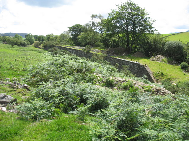
Junction south of the Trawsfynydd Nuclear Power Station was dismantled in the early 1960s. The platform of the military station is well preserved.
1099:
1094:
37:
1136:
1131:
688:
618:
582:
284:
234:
738:
1255:
319:
1147:
This file contains additional information, probably added from the digital camera or scanner used to create or digitize it.
839:
409:
517:
1031:
994:
960:
923:
894:
867:
823:
794:
767:
716:
672:
566:
540:
525:
510:
731:
701:
638:
602:
483:
466:
306:
365:
1150:
If the file has been modified from its original state, some details may not fully reflect the modified file.
1127:
The following pages on the
English Knowledge (XXG) use this file (pages on other projects are not listed):
1300:
408:– If you remix, transform, or build upon the material, you must distribute your contributions under the
326:
on the
Geograph website for the photographer's contact details. The copyright on this image is owned by
1110:
1169:
362:
860:"}},"text\/plain":{"en":{"P7787":"180 degree"}}}}": -->
760:"}},"text\/plain":{"en":{"P7787":"180 degree"}}}}": -->
1328:
86:
179:
723:
708:
532:
163:
1159:
290:
240:
1396:
1318:
1282:
1176:
331:
73:
1406:
1205:
111:
The former military railway station at
Trawsfynydd - geograph.org.uk - 510965.jpg
47:
The_former_military_railway_station_at_Trawsfynydd_-_geograph.org.uk_-_510965.jpg
1338:
131:
274:
224:
152:
142:
1186:
311:
323:
1067:
Click on a date/time to view the file as it appeared at that time.
276:
226:
251:
201:
61:
261:
52° 54′ 30″ N, 3° 55′ 00″ W
211:
52° 54′ 35″ N, 3° 54′ 59″ W
450:
Add a one-line explanation of what this file represents
1333:
Flash did not fire, auto mode, red-eye reduction mode
105:
85:
Commons is a freely licensed media file repository.
619:
Creative
Commons Attribution-ShareAlike 2.0 Generic
194:The former military railway station at Trawsfynydd
175:The former military railway station at Trawsfynydd
51:(640 × 480 pixels, file size: 141 KB, MIME type:
419:https://creativecommons.org/licenses/by-sa/2.0
66:
425:Creative Commons Attribution-Share Alike 2.0
343:
8:
857:
757:
385:– to copy, distribute and transmit the work
1152:
1069:
446:
709:https://www.geograph.org.uk/photo/510965
533:https://www.geograph.org.uk/profile/7056
1415:
1404:
1394:
1386:
1378:
1370:
1362:
1354:
1346:
1336:
1326:
1316:
1308:
1298:
1290:
1280:
1272:
1264:
1253:
1245:
1237:
1229:
1221:
1213:
1202:
1194:
1184:
1174:
1164:
1137:Portal:Trains/Did you know/January 2020
1129:
1045:
1029:
1008:
992:
974:
958:
937:
921:
881:
865:
837:
821:
781:
765:
686:
670:
652:
636:
616:
600:
580:
564:
497:
481:
464:
461:
442:
435:
254:
204:
283:View this and other nearby images on:
233:View this and other nearby images on:
1154:
7:
330:and is licensed for reuse under the
1058:
366:Attribution-Share Alike 2.0 Generic
354:
349:
334:Attribution-ShareAlike 2.0 license.
1145:
455:
449:
340:
317:
115:
98:
44:
454:
1196:Date and time of data generation
1132:Trawsfynydd Camp railway station
768:coordinates of the point of view
440:
396:Under the following conditions:
361:This file is licensed under the
353:
348:
342:
310:
289:
275:
267:
239:
225:
217:
65:
21:
437:
116:
41:No higher resolution available.
14:
689:file available on the internet
436:
318:This image was taken from the
26:
1:
868:coordinates of depicted place
31:
739:Geograph Britain and Ireland
511:object of statement has role
462:Items portrayed in this file
266:
216:
1364:Focal plane resolution unit
1266:Date and time of digitizing
883:52°54'29.99"N, 3°54'59.76"W
1437:
1375:One-chip color area sensor
410:same or compatible license
1239:File change date and time
1059:
783:52°54'34.6"N, 3°54'58.7"W
16:
1356:Focal plane Y resolution
1348:Focal plane X resolution
717:geograph.org.uk image ID
439:
376:
72:This is a file from the
1380:Custom image processing
1116:
192:Eric Jones /
173:Eric Jones /
164:required by the license
148:
137:
130:
127:
108:
76:. Information from its
1274:Image compression mode
1095:14:15, 5 February 2011
324:this photograph's page
295:52.908330; -3.916600
245:52.909600; -3.916300
79:description page there
1310:Maximum land aperture
1223:Horizontal resolution
1313:2.96875 APEX (f/2.8)
1170:Canon PowerShot A610
840:Canon PowerShot A610
1269:13:33, 28 July 2007
1247:Y and C positioning
1242:13:33, 28 July 2007
1231:Vertical resolution
1199:13:33, 28 July 2007
1181:1/800 sec (0.00125)
1156:Camera manufacturer
391:– to adapt the work
1417:Scene capture type
1401:Auto white balance
541:author name string
1424:
1423:
1120:
859:
759:
603:copyright license
448:
339:
338:
322:collection. See
300:
299:
250:
249:
199:
198:
167:
94:
93:
74:Wikimedia Commons
1428:
1359:9,169.8113207547
1351:9,159.0106007067
1153:
1107:
1013:
942:
905:
904:
899:
805:
804:
799:
741:
736:
726:
721:
711:
706:
702:described at URL
567:copyright status
548:
545:
535:
530:
520:
515:
432:
429:
426:
423:
420:
412:as the original.
374:
363:Creative Commons
357:
356:
352:
351:
346:
345:
332:Creative Commons
320:Geograph project
314:
307:
296:
293:
279:
278:
272:
271:
270:
264:
263:
252:
246:
243:
229:
228:
222:
221:
220:
214:
213:
202:
161:
133:
120:
112:
106:
90:
69:
68:
62:
56:
54:
1436:
1435:
1431:
1430:
1429:
1427:
1426:
1425:
1141:
1128:
1121:
1113:
1105:
1061:
1060:
1057:
1056:
1055:
1054:
1053:
1052:
1051:
1050:
1048:
1038:
1037:
1036:
1034:
1023:
1022:
1021:
1020:
1019:
1018:
1017:
1016:
1014:
1011:
1001:
1000:
999:
997:
986:
985:
984:
983:
982:
981:
980:
979:
977:
967:
966:
965:
963:
952:
951:
950:
949:
948:
947:
946:
945:
943:
940:
930:
929:
928:
926:
915:
914:
913:
912:
911:
910:
909:
908:
907:
906:
902:
900:
897:
888:
887:
886:
884:
874:
873:
872:
870:
851:
850:
849:
848:
847:
846:
845:
844:
842:
830:
829:
828:
826:
815:
814:
813:
812:
811:
810:
809:
808:
807:
806:
802:
800:
797:
788:
787:
786:
784:
774:
773:
772:
770:
751:
750:
749:
748:
747:
746:
745:
744:
743:
742:
737:
734:
728:
727:
722:
719:
713:
712:
707:
704:
695:
694:
693:
691:
679:
678:
677:
675:
664:
663:
662:
661:
660:
659:
658:
657:
655:
645:
644:
643:
641:
630:
629:
628:
627:
626:
625:
624:
623:
621:
609:
608:
607:
605:
594:
593:
592:
591:
590:
589:
588:
587:
585:
573:
572:
571:
569:
558:
557:
556:
555:
554:
553:
552:
551:
550:
549:
546:
543:
537:
536:
531:
528:
522:
521:
516:
513:
504:
503:
502:
500:
490:
489:
488:
486:
475:
474:
473:
472:
471:
469:
453:
452:
451:
434:
433:
430:
427:
424:
421:
418:
417:
375:
372:
369:
358:
335:
305:
294:
268:
259:
258:
255:Object location
244:
218:
209:
208:
205:Camera location
200:
189:
182:
170:
143:geograph.org.uk
123:
110:
103:
96:
95:
84:
83:
82:is shown below.
58:
52:
50:
43:
42:
12:
11:
5:
1434:
1432:
1422:
1421:
1418:
1414:
1413:
1410:
1403:
1402:
1399:
1393:
1392:
1389:
1385:
1384:
1383:Normal process
1381:
1377:
1376:
1373:
1372:Sensing method
1369:
1368:
1365:
1361:
1360:
1357:
1353:
1352:
1349:
1345:
1344:
1341:
1335:
1334:
1331:
1325:
1324:
1321:
1315:
1314:
1311:
1307:
1306:
1303:
1297:
1296:
1293:
1289:
1288:
1285:
1279:
1278:
1275:
1271:
1270:
1267:
1263:
1262:
1259:
1252:
1251:
1248:
1244:
1243:
1240:
1236:
1235:
1232:
1228:
1227:
1224:
1220:
1219:
1216:
1212:
1211:
1208:
1201:
1200:
1197:
1193:
1192:
1189:
1183:
1182:
1179:
1173:
1172:
1167:
1163:
1162:
1157:
1144:
1140:
1139:
1134:
1126:
1125:
1124:
1119:
1118:
1115:
1111:
1108:
1102:
1097:
1092:
1088:
1087:
1084:
1081:
1078:
1075:
1072:
1065:
1064:
1049:
1046:
1044:
1043:
1042:
1041:
1040:
1039:
1035:
1030:
1028:
1027:
1026:
1025:
1024:
1015:
1009:
1007:
1006:
1005:
1004:
1003:
1002:
998:
993:
991:
990:
989:
988:
987:
978:
975:
973:
972:
971:
970:
969:
968:
964:
959:
957:
956:
955:
954:
953:
944:
938:
936:
935:
934:
933:
932:
931:
927:
922:
920:
919:
918:
917:
916:
893:
892:
891:
890:
889:
885:
882:
880:
879:
878:
877:
876:
875:
871:
866:
864:
863:
862:
861:
855:
843:
838:
836:
835:
834:
833:
832:
831:
827:
822:
820:
819:
818:
817:
816:
793:
792:
791:
790:
789:
785:
782:
780:
779:
778:
777:
776:
775:
771:
766:
764:
763:
762:
761:
755:
730:
729:
715:
714:
700:
699:
698:
697:
696:
692:
687:
685:
684:
683:
682:
681:
680:
676:
673:source of file
671:
669:
668:
667:
666:
665:
656:
653:
651:
650:
649:
648:
647:
646:
642:
637:
635:
634:
633:
632:
631:
622:
617:
615:
614:
613:
612:
611:
610:
606:
601:
599:
598:
597:
596:
595:
586:
581:
579:
578:
577:
576:
575:
574:
570:
565:
563:
562:
561:
560:
559:
539:
538:
524:
523:
509:
508:
507:
506:
505:
501:
498:
496:
495:
494:
493:
492:
491:
487:
482:
480:
479:
478:
477:
476:
470:
465:
463:
460:
459:
458:
457:
456:
445:
444:
441:
438:
416:
415:
414:
413:
403:
394:
393:
392:
386:
379:You are free:
370:
360:
359:
341:
337:
336:
315:
304:
301:
298:
297:
287:
281:
256:
248:
247:
237:
231:
206:
197:
196:
190:
187:
184:
183:
178:
171:
168:
156:
155:
150:
146:
145:
139:
135:
134:
129:
125:
124:
113:
104:
102:
99:
97:
92:
91:
70:
60:
59:
40:
36:
35:
34:
29:
24:
19:
13:
10:
9:
6:
4:
3:
2:
1433:
1419:
1416:
1411:
1408:
1405:
1400:
1398:
1397:White balance
1395:
1391:Auto exposure
1390:
1388:Exposure mode
1387:
1382:
1379:
1374:
1371:
1366:
1363:
1358:
1355:
1350:
1347:
1342:
1340:
1337:
1332:
1330:
1327:
1322:
1320:
1319:Metering mode
1317:
1312:
1309:
1304:
1302:
1301:Exposure bias
1299:
1294:
1292:APEX aperture
1291:
1286:
1284:
1283:Shutter speed
1281:
1276:
1273:
1268:
1265:
1260:
1257:
1254:
1249:
1246:
1241:
1238:
1233:
1230:
1225:
1222:
1217:
1214:
1209:
1207:
1203:
1198:
1195:
1190:
1188:
1185:
1180:
1178:
1177:Exposure time
1175:
1171:
1168:
1165:
1161:
1158:
1155:
1151:
1148:
1142:
1138:
1135:
1133:
1130:
1122:
1114:
1109:
1103:
1101:
1098:
1096:
1093:
1090:
1089:
1085:
1082:
1079:
1076:
1073:
1071:
1070:
1068:
1062:
1033:
996:
962:
925:
924:exposure time
896:
869:
841:
825:
824:captured with
796:
769:
740:
733:
725:
718:
710:
703:
690:
674:
640:
620:
604:
584:
568:
542:
534:
527:
519:
512:
485:
468:
422:CC BY-SA 2.0
411:
407:
404:
401:
398:
397:
395:
390:
387:
384:
381:
380:
378:
377:
371:Attribution:
367:
364:
347:
333:
329:
325:
321:
316:
313:
309:
308:
302:
292:
288:
286:
285:OpenStreetMap
282:
280:
262:
257:
253:
242:
238:
236:
235:OpenStreetMap
232:
230:
212:
207:
203:
195:
191:
186:
185:
181:
177: /
176:
172:
165:
160:
158:
157:
154:
151:
147:
144:
140:
136:
126:
119:
114:
107:
100:
88:
81:
80:
75:
71:
64:
63:
57:
48:
39:
33:
30:
28:
25:
23:
20:
18:
15:
1407:Digital zoom
1206:focal length
1166:Camera model
1149:
1146:
1066:
1063:File history
995:focal length
654:28 July 2007
518:photographer
405:
399:
388:
382:
327:
265:
215:
193:
180:CC BY-SA 2.0
174:
132:28 July 2007
117:
87:You can help
77:
45:
22:File history
1339:Color space
1215:Orientation
1112:GeographBot
583:copyrighted
406:share alike
400:attribution
159:Attribution
109:Description
1123:File usage
1104:640 × 480
1080:Dimensions
1047:image/jpeg
1032:media type
1012:millimetre
547:Eric Jones
499:some value
373:Eric Jones
328:Eric Jones
153:Eric Jones
53:image/jpeg
27:File usage
1077:Thumbnail
1074:Date/Time
639:inception
303:Licensing
188:InfoField
169:InfoField
118:English:
1420:Portrait
1250:Centered
1187:F-number
1143:Metadata
1106:(141 KB)
961:f-number
939:0.00125
732:operator
443:Captions
389:to remix
383:to share
368:license.
32:Metadata
1323:Pattern
1295:2.96875
1287:9.65625
1258:version
1234:180 dpi
1226:180 dpi
1091:current
1086:Comment
895:heading
854:heading
795:heading
754:heading
484:creator
467:depicts
447:English
101:Summary
49:
1367:inches
1218:Normal
1210:7.3 mm
941:second
903:degree
858:degree
803:degree
758:degree
724:510965
273:
223:
149:Author
138:Source
1409:ratio
1329:Flash
1204:Lens
1191:f/2.8
1160:Canon
141:From
1343:sRGB
1256:Exif
1083:User
1010:7.3
901:180
801:180
431:true
428:true
128:Date
17:File
1261:2.2
976:2.8
526:URL
898::
798::
735::
720::
705::
544::
529::
514::
1412:1
1305:0
1277:3
166:)
162:(
89:.
55:)
Text is available under the Creative Commons Attribution-ShareAlike License. Additional terms may apply.
_heading:180.00&language=en)
_heading:180.00&language=en)
