367:
300:
250:
292:
242:
314:
264:
335:
373:
378:
72:
879:"}},"text\/plain":{"en":{"":"heading"}}},"{\"value\":{\"amount\":\"+315\",\"unit\":\"http:\\\/\\\/www.wikidata.org\\\/entity\\\/Q28390\"},\"type\":\"quantity\"}":{"text\/html":{"en":{"P7787":"315
779:"}},"text\/plain":{"en":{"":"heading"}}},"{\"value\":{\"amount\":\"+315\",\"unit\":\"http:\\\/\\\/www.wikidata.org\\\/entity\\\/Q28390\"},\"type\":\"quantity\"}":{"text\/html":{"en":{"P7787":"315
981:
775:
233:
43:
998:== {{int:filedesc}} == {{Information |description={{en|1=The remains of Blanerne Castle near Edrom Set in Crow Wood a short distance to the southwest of Blanerne House and the original seat of the Lumsdaine family. The 16th century castle is a Category B
144:
The remains of
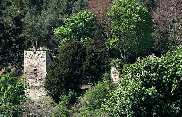
Blanerne Castle near Edrom Set in Crow Wood a short distance to the southwest of Blanerne House and the original seat of the Lumsdaine family. The 16th century castle is a scheduled monument. Viewed from a minor road near Todheugh
83:
51:
425:– You must give appropriate credit, provide a link to the license, and indicate if changes were made. You may do so in any reasonable manner, but not in any way that suggests the licensor endorses you or your use.
876:
776:
1022:
980:
975:
42:
677:
641:
605:
307:
257:
697:
1220:
342:
1083:
This file contains additional information, probably added from the digital camera or scanner used to create or digitize it.
432:
862:
568:
917:
890:
846:
817:
790:
705:
661:
589:
561:
546:
533:
748:
720:
690:
625:
506:
489:
1189:
329:
1060:
388:
1086:
If the file has been modified from its original state, some details may not fully reflect the modified file.
1105:
1008:
The following pages on the
English Knowledge (XXG) use this file (pages on other projects are not listed):
1257:
431:– If you remix, transform, or build upon the material, you must distribute your contributions under the
349:
on the
Geograph website for the photographer's contact details. The copyright on this image is owned by
991:
385:
883:"}},"text\/plain":{"en":{"P7787":"315 degree"}}}}": -->
783:"}},"text\/plain":{"en":{"P7787":"315 degree"}}}}": -->
110:
1277:
91:
115:
727:
712:
553:
186:
1095:
1012:
313:
263:
1337:
1267:
1239:
1112:
354:
78:
1152:
1017:
202:
1287:
154:
1132:
297:
247:
165:
175:
1122:
334:
134:
The remains of
Blanerne Castle near Edrom - geograph.org.uk - 1288674.jpg
52:
The_remains_of_Blanerne_Castle_near_Edrom_-_geograph.org.uk_-_1288674.jpg
346:
104:
948:
Click on a date/time to view the file as it appeared at that time.
299:
249:
274:
224:
66:
1050:
1040:
284:
55° 48′ 01.3″ N, 2° 16′ 11″ W
234:
55° 47′ 51.6″ N, 2° 15′ 51″ W
473:
Add a one-line explanation of what this file represents
1070:
128:
90:
Commons is a freely licensed media file repository.
642:
Creative
Commons Attribution-ShareAlike 2.0 Generic
56:(640 × 413 pixels, file size: 131 KB, MIME type:
1282:Flash did not fire, compulsory flash suppression
442:https://creativecommons.org/licenses/by-sa/2.0
71:
448:Creative Commons Attribution-Share Alike 2.0
366:
8:
1023:Scheduled monuments in the Scottish Borders
880:
780:
408:– to copy, distribute and transmit the work
1088:
950:
469:
1033:The following other wikis use this file:
728:https://www.geograph.org.uk/photo/1288674
217:The remains of Blanerne Castle near Edrom
198:The remains of Blanerne Castle near Edrom
554:https://www.geograph.org.uk/profile/6638
1345:
1335:
1327:
1319:
1311:
1303:
1295:
1285:
1275:
1265:
1255:
1247:
1237:
1229:
1218:
1210:
1202:
1194:
1184:
1176:
1168:
1160:
1149:
1141:
1130:
1120:
1110:
1100:
1010:
904:
888:
860:
844:
804:
788:
762:
746:
675:
659:
639:
623:
603:
587:
520:
504:
487:
484:
465:
458:
277:
227:
306:View this and other nearby images on:
256:View this and other nearby images on:
1090:
7:
353:and is licensed for reuse under the
939:
389:Attribution-Share Alike 2.0 Generic
377:
372:
357:Attribution-ShareAlike 2.0 license.
1081:
478:
472:
363:
340:
138:
108:
103:
49:
477:
1143:Date and time of data generation
791:coordinates of the point of view
463:
419:Under the following conditions:
384:This file is licensed under the
376:
371:
365:
333:
312:
298:
290:
262:
248:
240:
70:
31:
21:
460:
139:
46:No higher resolution available.
14:
678:file available on the internet
459:
341:This image was taken from the
26:
1:
891:coordinates of depicted place
36:
698:Geograph Britain and Ireland
562:object of statement has role
485:Items portrayed in this file
289:
239:
1313:Focal plane resolution unit
1231:Date and time of digitizing
806:55°47'51.65"N, 2°15'51.48"W
1367:
1190:Adobe Photoshop CS Windows
1067:Usage on www.wikidata.org
1057:Usage on uk.wikipedia.org
1047:Usage on pt.wikipedia.org
1037:Usage on de.wikipedia.org
906:55°48'1.33"N, 2°16'10.56"W
433:same or compatible license
215:Walter Baxter /
196:Walter Baxter /
1196:File change date and time
940:
16:
1305:Focal plane Y resolution
1297:Focal plane X resolution
706:geograph.org.uk image ID
462:
399:
77:This is a file from the
1321:Custom image processing
997:
976:07:30, 27 February 2011
187:required by the license
171:
160:
153:
150:
131:
81:. Information from its
1106:Canon EOS 400D DIGITAL
347:this photograph's page
318:55.800370; -2.269600
268:55.797680; -2.264300
84:description page there
1170:Horizontal resolution
1204:Y and C positioning
1178:Vertical resolution
1092:Camera manufacturer
414:– to adapt the work
109:This is a photo of
1347:Scene capture type
1342:Auto white balance
1117:1/400 sec (0.0025)
534:author name string
111:scheduled monument
1354:
1353:
1234:14:28, 2 May 2009
1199:22:10, 2 May 2009
1146:14:28, 2 May 2009
1029:Global file usage
1001:
882:
782:
626:copyright license
471:
362:
361:
345:collection. See
323:
322:
273:
272:
222:
221:
190:
121:
120:
99:
98:
79:Wikimedia Commons
32:Global file usage
1358:
1308:4,453.6082474227
1300:4,433.2953249715
1212:Exposure Program
1089:
1051:Castelo Blanerne
988:
928:
927:
922:
828:
827:
822:
730:
725:
721:described at URL
715:
710:
700:
695:
590:copyright status
571:
566:
556:
551:
541:
538:
455:
452:
449:
446:
443:
435:as the original.
397:
386:Creative Commons
380:
379:
375:
374:
369:
368:
355:Creative Commons
343:Geograph project
337:
330:
319:
316:
302:
301:
295:
294:
293:
287:
286:
275:
269:
266:
252:
251:
245:
244:
243:
237:
236:
225:
184:
156:
143:
135:
129:
105:
95:
74:
73:
67:
61:
59:
1366:
1365:
1361:
1360:
1359:
1357:
1356:
1355:
1252:5.6556396484375
1244:8.6438598632812
1077:
1041:Blanerne Castle
1027:
1013:Blanerne Castle
1009:
1002:
994:
986:
942:
941:
938:
937:
936:
935:
934:
933:
932:
931:
930:
929:
925:
923:
920:
911:
910:
909:
907:
897:
896:
895:
893:
874:
873:
872:
871:
870:
869:
868:
867:
865:
853:
852:
851:
849:
838:
837:
836:
835:
834:
833:
832:
831:
830:
829:
825:
823:
820:
811:
810:
809:
807:
797:
796:
795:
793:
774:
773:
772:
771:
770:
769:
768:
767:
765:
755:
754:
753:
751:
740:
739:
738:
737:
736:
735:
734:
733:
732:
731:
726:
723:
717:
716:
711:
708:
702:
701:
696:
693:
684:
683:
682:
680:
668:
667:
666:
664:
653:
652:
651:
650:
649:
648:
647:
646:
644:
632:
631:
630:
628:
617:
616:
615:
614:
613:
612:
611:
610:
608:
596:
595:
594:
592:
581:
580:
579:
578:
577:
576:
575:
574:
573:
572:
567:
564:
558:
557:
552:
549:
543:
542:
539:
536:
527:
526:
525:
523:
513:
512:
511:
509:
498:
497:
496:
495:
494:
492:
476:
475:
474:
457:
456:
453:
450:
447:
444:
441:
440:
398:
395:
392:
381:
358:
328:
317:
291:
282:
281:
278:Object location
267:
241:
232:
231:
228:Camera location
223:
212:
205:
193:
166:geograph.org.uk
146:
133:
126:
114:
101:
100:
89:
88:
87:is shown below.
63:
57:
55:
48:
47:
12:
11:
5:
1364:
1362:
1352:
1351:
1348:
1344:
1343:
1340:
1334:
1333:
1330:
1326:
1325:
1324:Normal process
1322:
1318:
1317:
1314:
1310:
1309:
1306:
1302:
1301:
1298:
1294:
1293:
1290:
1284:
1283:
1280:
1274:
1273:
1270:
1264:
1263:
1260:
1254:
1253:
1250:
1246:
1245:
1242:
1236:
1235:
1232:
1228:
1227:
1224:
1217:
1216:
1215:Normal program
1213:
1209:
1208:
1205:
1201:
1200:
1197:
1193:
1192:
1187:
1183:
1182:
1179:
1175:
1174:
1171:
1167:
1166:
1163:
1159:
1158:
1155:
1148:
1147:
1144:
1140:
1139:
1136:
1129:
1128:
1125:
1119:
1118:
1115:
1109:
1108:
1103:
1099:
1098:
1093:
1080:
1076:
1075:
1074:
1073:
1065:
1064:
1063:
1055:
1054:
1053:
1045:
1044:
1043:
1031:
1030:
1026:
1025:
1020:
1015:
1007:
1006:
1005:
1000:
999:
996:
992:
989:
983:
978:
973:
969:
968:
965:
962:
959:
956:
953:
946:
945:
916:
915:
914:
913:
912:
908:
905:
903:
902:
901:
900:
899:
898:
894:
889:
887:
886:
885:
884:
878:
866:
863:Canon EOS 400D
861:
859:
858:
857:
856:
855:
854:
850:
845:
843:
842:
841:
840:
839:
816:
815:
814:
813:
812:
808:
805:
803:
802:
801:
800:
799:
798:
794:
789:
787:
786:
785:
784:
778:
766:
763:
761:
760:
759:
758:
757:
756:
752:
747:
745:
744:
743:
742:
741:
719:
718:
704:
703:
689:
688:
687:
686:
685:
681:
676:
674:
673:
672:
671:
670:
669:
665:
662:source of file
660:
658:
657:
656:
655:
654:
645:
640:
638:
637:
636:
635:
634:
633:
629:
624:
622:
621:
620:
619:
618:
609:
604:
602:
601:
600:
599:
598:
597:
593:
588:
586:
585:
584:
583:
582:
560:
559:
545:
544:
532:
531:
530:
529:
528:
524:
521:
519:
518:
517:
516:
515:
514:
510:
505:
503:
502:
501:
500:
499:
493:
488:
486:
483:
482:
481:
480:
479:
468:
467:
464:
461:
439:
438:
437:
436:
426:
417:
416:
415:
409:
402:You are free:
393:
383:
382:
364:
360:
359:
338:
327:
324:
321:
320:
310:
304:
279:
271:
270:
260:
254:
229:
220:
219:
213:
210:
207:
206:
201:
194:
191:
179:
178:
173:
169:
168:
162:
158:
157:
152:
148:
147:
136:
127:
125:
122:
119:
118:
102:
97:
96:
75:
65:
64:
45:
41:
40:
39:
34:
29:
24:
19:
13:
10:
9:
6:
4:
3:
2:
1363:
1349:
1346:
1341:
1339:
1338:White balance
1336:
1332:Auto exposure
1331:
1329:Exposure mode
1328:
1323:
1320:
1315:
1312:
1307:
1304:
1299:
1296:
1291:
1289:
1286:
1281:
1279:
1276:
1271:
1269:
1268:Metering mode
1266:
1261:
1259:
1258:Exposure bias
1256:
1251:
1249:APEX aperture
1248:
1243:
1241:
1240:Shutter speed
1238:
1233:
1230:
1225:
1222:
1219:
1214:
1211:
1206:
1203:
1198:
1195:
1191:
1188:
1186:Software used
1185:
1180:
1177:
1172:
1169:
1164:
1161:
1156:
1154:
1150:
1145:
1142:
1137:
1134:
1131:
1126:
1124:
1121:
1116:
1114:
1113:Exposure time
1111:
1107:
1104:
1101:
1097:
1094:
1091:
1087:
1084:
1078:
1072:
1069:
1068:
1066:
1062:
1059:
1058:
1056:
1052:
1049:
1048:
1046:
1042:
1039:
1038:
1036:
1035:
1034:
1028:
1024:
1021:
1019:
1016:
1014:
1011:
1003:
995:
990:
984:
982:
979:
977:
974:
971:
970:
966:
963:
960:
957:
954:
952:
951:
949:
943:
919:
892:
864:
848:
847:captured with
819:
792:
750:
729:
722:
714:
707:
699:
692:
679:
663:
643:
627:
607:
591:
570:
563:
555:
548:
540:Walter Baxter
535:
508:
491:
445:CC BY-SA 2.0
434:
430:
427:
424:
421:
420:
418:
413:
410:
407:
404:
403:
401:
400:
396:Walter Baxter
394:Attribution:
390:
387:
370:
356:
352:
351:Walter Baxter
348:
344:
339:
336:
332:
331:
325:
315:
311:
309:
308:OpenStreetMap
305:
303:
285:
280:
276:
265:
261:
259:
258:OpenStreetMap
255:
253:
235:
230:
226:
218:
214:
209:
208:
204:
200: /
199:
195:
188:
183:
181:
180:
177:
176:Walter Baxter
174:
170:
167:
163:
159:
149:
142:
137:
130:
123:
117:
112:
107:
106:
93:
86:
85:
80:
76:
69:
68:
62:
53:
44:
38:
35:
33:
30:
28:
25:
23:
20:
18:
15:
1153:focal length
1102:Camera model
1085:
1082:
1061:Клан Ламсден
1032:
1018:Clan Lumsden
947:
944:File history
569:photographer
428:
422:
411:
405:
350:
288:
238:
216:
203:CC BY-SA 2.0
197:
140:
92:You can help
82:
50:
22:File history
1288:Color space
1162:Orientation
993:GeographBot
606:copyrighted
429:share alike
423:attribution
182:Attribution
132:Description
1004:File usage
985:640 × 413
961:Dimensions
764:2 May 2009
522:some value
155:2 May 2009
58:image/jpeg
27:File usage
1133:ISO speed
958:Thumbnail
955:Date/Time
749:inception
326:Licensing
211:InfoField
192:InfoField
141:English:
1350:Standard
1207:Co-sited
1123:F-number
1079:Metadata
1071:Q4925057
987:(131 KB)
691:operator
466:Captions
412:to remix
406:to share
391:license.
37:Metadata
1272:Pattern
1223:version
972:current
967:Comment
918:heading
877:heading
818:heading
777:heading
713:1288674
507:creator
490:depicts
470:English
124:Summary
54:
1316:inches
1181:72 dpi
1173:72 dpi
1165:Normal
1157:270 mm
1135:rating
926:degree
881:degree
826:degree
781:degree
296:
246:
172:Author
161:Source
113:number
1278:Flash
1151:Lens
1127:f/7.1
1096:Canon
164:From
145:Farm.
1292:sRGB
1226:2.21
1221:Exif
964:User
924:315
824:315
454:true
451:true
151:Date
116:4216
17:File
1138:400
547:URL
921::
821::
724::
709::
694::
565::
550::
537::
1262:0
189:)
185:(
94:.
60:)
Text is available under the Creative Commons Attribution-ShareAlike License. Additional terms may apply.
_heading:315.00&language=en)
_heading:315.00&language=en)
