238:
199:
213:
244:
249:
38:
90:
666:
290:– You must give appropriate credit, provide a link to the license, and indicate if changes were made. You may do so in any reasonable manner, but not in any way that suggests the licensor endorses you or your use.
190:
56:
52:
48:
42:
101:
69:
173:
893:
543:
507:
471:
206:
916:
713:
This file contains additional information, probably added from the digital camera or scanner used to create or digitize it.
297:
597:
527:
455:
427:
414:
399:
563:
491:
372:
355:
434:
259:
716:
If the file has been modified from its original state, some details may not fully reflect the modified file.
665:
660:
60:
37:
697:
693:
The following pages on the
English Knowledge (XXG) use this file (pages on other projects are not listed):
953:
296:– If you remix, transform, or build upon the material, you must distribute your contributions under the
256:
997:
676:
109:
1094:
406:
153:
212:
1049:
979:
935:
742:
702:
96:
231:
I, the copyright holder of this work, hereby publish it under the following license:
1104:
1059:
782:
1007:
196:
762:
1114:
752:
735:
633:
Click on a date/time to view the file as it appeared at that time.
590:
198:
725:
191:
51° 27′ 51.33″ N, 0° 18′ 31.5″ E
181:
84:
508:
Creative
Commons Attribution-ShareAlike 4.0 International
339:
Add a one-line explanation of what this file represents
128:
108:
Commons is a freely licensed media file repository.
74:(1,200 × 885 pixels, file size: 614 KB, MIME type:
307:https://creativecommons.org/licenses/by-sa/4.0
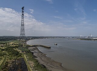
144:View of the Kent 400 kV Thames crossing tower.
89:
313:Creative Commons Attribution-Share Alike 4.0
237:
8:
273:– to copy, distribute and transmit the work
718:
635:
407:https://commons.wikimedia.org/user:Rosepen
335:
260:Attribution-Share Alike 4.0 International
134:The 400 kV Thames Crossing Kent tower.jpg
1170:
1162:
1154:
1146:
1138:
1130:
1122:
1112:
1102:
1092:
1084:
1076:
1068:
1057:
1047:
1039:
1031:
1023:
1015:
1005:
995:
987:
977:
969:
961:
951:
943:
933:
925:
914:
906:
898:
888:
880:
872:
864:
856:
848:
830:
822:
814:
806:
798:
790:
779:
771:
760:
750:
740:
730:
695:
611:
595:
577:
561:
541:
525:
505:
489:
469:
453:
386:
370:
353:
350:
331:
324:
184:
205:View this and other nearby images on:
1002:Flash did not fire, No flash function
720:
7:
894:Adobe Photoshop CC 2018 (Macintosh)
683:User created page with UploadWizard
624:
248:
243:
711:
344:
338:
234:
230:
138:
121:
67:
343:
1175:027F6F3DE831C6C953924BD6F9E60E70
1143:3eddd4e06b7e7adad30094e87f0669aa
773:Date and time of data generation
598:coordinates of the point of view
329:
284:Under the following conditions:
255:This file is licensed under the
247:
242:
236:
211:
197:
88:
21:
1164:Date metadata was last modified
326:
139:
14:
1172:Unique ID of original document
325:
26:
1:
1028:A directly photographed image
811:40.306 meters above sea level
613:51°27'51.329"N, 0°18'31.500"E
544:original creation by uploader
31:
351:Items portrayed in this file
927:Date and time of digitizing
1192:
1070:Focal length in 35 mm film
298:same or compatible license
900:File change date and time
625:
163:
16:
328:
264:
95:This is a file from the
1140:Serial number of camera
1033:Custom image processing
984:Center weighted average
682:
169:
159:
152:
149:
131:
99:. Information from its
1124:Subject distance range
698:400 kV Thames Crossing
217:51.464258; 0.308750
102:description page there
41:Size of this preview:
963:Maximum land aperture
874:Horizontal resolution
154:4 July 2018, 11:09:21
1020:Digital still camera
866:Number of components
747:1/2,000 sec (0.0005)
882:Vertical resolution
722:Camera manufacturer
279:– to adapt the work
47:Other resolutions:
1167:18:47, 4 July 2018
1078:Scene capture type
1054:Auto white balance
930:11:09, 4 July 2018
903:17:47, 4 July 2018
832:Bits per component
776:11:09, 4 July 2018
661:07:28, 7 July 2018
428:Wikimedia username
415:author name string
61:1,200 × 885 pixels
57:1,024 × 755 pixels
1179:
1178:
1156:Rating (out of 5)
966:2.97 APEX (f/2.8)
850:Pixel composition
686:
492:copyright license
337:
222:
221:
179:
178:
117:
116:
97:Wikimedia Commons
1183:
971:Subject distance
908:Exposure Program
795:51° 27′ 51.33″ N
719:
673:
456:copyright status
437:
432:
422:
419:
409:
404:
320:
317:
314:
311:
308:
300:as the original.
257:Creative Commons
251:
250:
246:
245:
240:
239:
218:
215:
201:
200:
194:
193:
182:
165:
155:
143:
135:
129:
113:
92:
91:
85:
79:
77:
64:
53:640 × 472 pixels
49:320 × 236 pixels
43:800 × 590 pixels
1191:
1190:
1186:
1185:
1184:
1182:
1181:
1180:
1132:GPS tag version
707:
694:
687:
679:
671:
627:
626:
623:
622:
621:
620:
619:
618:
617:
616:
614:
604:
603:
602:
600:
589:
588:
587:
586:
585:
584:
583:
582:
580:
570:
569:
568:
566:
555:
554:
553:
552:
551:
550:
549:
548:
546:
534:
533:
532:
530:
519:
518:
517:
516:
515:
514:
513:
512:
510:
498:
497:
496:
494:
483:
482:
481:
480:
479:
478:
477:
476:
474:
462:
461:
460:
458:
447:
446:
445:
444:
443:
442:
441:
440:
439:
438:
433:
430:
424:
423:
420:
417:
411:
410:
405:
402:
393:
392:
391:
389:
379:
378:
377:
375:
364:
363:
362:
361:
360:
358:
342:
341:
340:
323:
322:
321:
318:
315:
312:
309:
306:
305:
263:
252:
233:
232:
227:
216:
189:
188:
185:Camera location
180:
145:
133:
126:
119:
118:
107:
106:
105:is shown below.
81:
75:
73:
66:
65:
46:
12:
11:
5:
1189:
1187:
1177:
1176:
1173:
1169:
1168:
1165:
1161:
1160:
1157:
1153:
1152:
1149:
1145:
1144:
1141:
1137:
1136:
1133:
1129:
1128:
1125:
1121:
1120:
1117:
1111:
1110:
1107:
1101:
1100:
1097:
1091:
1090:
1087:
1083:
1082:
1079:
1075:
1074:
1071:
1067:
1066:
1063:
1056:
1055:
1052:
1046:
1045:
1042:
1038:
1037:
1036:Normal process
1034:
1030:
1029:
1026:
1022:
1021:
1018:
1014:
1013:
1010:
1004:
1003:
1000:
994:
993:
990:
986:
985:
982:
976:
975:
972:
968:
967:
964:
960:
959:
956:
950:
949:
946:
942:
941:
938:
932:
931:
928:
924:
923:
920:
913:
912:
911:Normal program
909:
905:
904:
901:
897:
896:
891:
887:
886:
883:
879:
878:
875:
871:
870:
867:
863:
862:
859:
855:
854:
851:
847:
846:
845:
844:
841:
838:
833:
829:
828:
825:
821:
820:
817:
813:
812:
809:
805:
804:
803:0° 18′ 31.5″ E
801:
797:
796:
793:
789:
788:
785:
778:
777:
774:
770:
769:
766:
759:
758:
755:
749:
748:
745:
739:
738:
733:
729:
728:
723:
710:
706:
705:
700:
692:
691:
690:
685:
684:
681:
677:
674:
668:
663:
658:
654:
653:
650:
647:
644:
641:
638:
631:
630:
615:
612:
610:
609:
608:
607:
606:
605:
601:
596:
594:
593:
592:
591:
581:
578:
576:
575:
574:
573:
572:
571:
567:
562:
560:
559:
558:
557:
556:
547:
542:
540:
539:
538:
537:
536:
535:
531:
528:source of file
526:
524:
523:
522:
521:
520:
511:
506:
504:
503:
502:
501:
500:
499:
495:
490:
488:
487:
486:
485:
484:
475:
470:
468:
467:
466:
465:
464:
463:
459:
454:
452:
451:
450:
449:
448:
426:
425:
413:
412:
398:
397:
396:
395:
394:
390:
387:
385:
384:
383:
382:
381:
380:
376:
371:
369:
368:
367:
366:
365:
359:
354:
352:
349:
348:
347:
346:
345:
334:
333:
330:
327:
304:
303:
302:
301:
291:
282:
281:
280:
274:
267:You are free:
254:
253:
235:
229:
228:
226:
223:
220:
219:
209:
203:
186:
177:
176:
171:
167:
166:
161:
157:
156:
151:
147:
146:
136:
127:
125:
122:
120:
115:
114:
93:
83:
82:
40:
36:
35:
34:
29:
24:
19:
13:
10:
9:
6:
4:
3:
2:
1188:
1174:
1171:
1166:
1163:
1158:
1155:
1150:
1147:
1142:
1139:
1134:
1131:
1126:
1123:
1118:
1116:
1113:
1108:
1106:
1103:
1098:
1096:
1093:
1088:
1086:Scene control
1085:
1080:
1077:
1072:
1069:
1064:
1061:
1058:
1053:
1051:
1050:White balance
1048:
1044:Auto exposure
1043:
1041:Exposure mode
1040:
1035:
1032:
1027:
1024:
1019:
1016:
1011:
1009:
1006:
1001:
999:
996:
991:
988:
983:
981:
980:Metering mode
978:
973:
970:
965:
962:
957:
955:
954:Exposure bias
952:
947:
945:APEX aperture
944:
939:
937:
936:Shutter speed
934:
929:
926:
921:
918:
915:
910:
907:
902:
899:
895:
892:
890:Software used
889:
884:
881:
876:
873:
868:
865:
860:
857:
852:
849:
842:
839:
836:
835:
834:
831:
826:
823:
818:
815:
810:
807:
802:
799:
794:
791:
786:
784:
780:
775:
772:
767:
764:
761:
756:
754:
751:
746:
744:
743:Exposure time
741:
737:
734:
731:
727:
724:
721:
717:
714:
708:
704:
703:Lattice tower
701:
699:
696:
688:
680:
675:
669:
667:
664:
662:
659:
656:
655:
651:
648:
645:
642:
639:
637:
636:
634:
628:
599:
565:
545:
529:
509:
493:
473:
457:
436:
429:
416:
408:
401:
374:
357:
310:CC BY-SA 4.0
299:
295:
292:
289:
286:
285:
283:
278:
275:
272:
269:
268:
266:
265:
261:
258:
241:
224:
214:
210:
208:
207:OpenStreetMap
204:
202:
192:
187:
183:
175:
172:
168:
162:
158:
148:
142:
137:
130:
123:
111:
104:
103:
98:
94:
87:
86:
80:
71:
70:Original file
62:
58:
54:
50:
44:
39:
33:
30:
28:
25:
23:
20:
18:
15:
1060:Digital zoom
1012:Uncalibrated
992:Fine weather
989:Light source
783:focal length
732:Camera model
715:
712:
670:1,200 × 885
632:
629:File history
421:Mervyn Rands
293:
287:
276:
270:
174:Mervyn Rands
140:
110:You can help
100:
68:
22:File history
1017:File source
1008:Color space
858:Orientation
579:4 July 2018
472:copyrighted
294:share alike
288:attribution
132:Description
1105:Saturation
1025:Scene type
689:File usage
646:Dimensions
388:some value
76:image/jpeg
27:File usage
1148:Lens used
1115:Sharpness
940:10.965784
800:Longitude
763:ISO speed
643:Thumbnail
640:Date/Time
564:inception
225:Licensing
141:English:
1095:Contrast
1081:Standard
974:0 meters
827:3,524 px
819:4,777 px
808:Altitude
792:Latitude
753:F-number
709:Metadata
672:(614 KB)
332:Captions
277:to remix
271:to share
262:license.
164:Own work
32:Metadata
1151:24.0 mm
1135:0.0.3.2
1127:Unknown
919:version
885:300 dpi
877:300 dpi
678:Rosepen
657:current
652:Comment
435:Rosepen
373:creator
356:depicts
336:English
124:Summary
72:
1119:Normal
1109:Normal
1099:Normal
861:Normal
824:Height
787:8.8 mm
765:rating
736:FC6310
195:
170:Author
160:Source
1073:24 mm
1062:ratio
998:Flash
816:Width
781:Lens
1089:None
917:Exif
649:User
319:true
316:true
150:Date
17:File
922:2.3
853:RGB
768:500
757:f/8
726:DJI
400:URL
431::
418::
403::
59:|
55:|
51:|
45:.
1159:0
1065:0
958:0
948:6
869:3
843:8
840:8
837:8
112:.
78:)
63:.
Text is available under the Creative Commons Attribution-ShareAlike License. Additional terms may apply.
