544:
436:
273:
43:
219:
265:
389:
287:
236:
550:
442:
226:
99:
447:
862:"}},"text\/plain":{"en":{"":"heading"}}},"{\"value\":{\"amount\":\"+270\",\"unit\":\"http:\\\/\\\/www.wikidata.org\\\/entity\\\/Q28390\"},\"type\":\"quantity\"}":{"text\/html":{"en":{"P7787":"270
858:
1214:
1389:
256:
591:– You must give appropriate credit, provide a link to the license, and indicate if changes were made. You may do so in any reasonable manner, but not in any way that suggests the licensor endorses you or your use.
495:– You must give appropriate credit, provide a link to the license, and indicate if changes were made. You may do so in any reasonable manner, but not in any way that suggests the licensor endorses you or your use.
1354:
859:
406:
404:; with no Invariant Sections, no Front-Cover Texts, and no Back-Cover Texts. A copy of the license is included in the section entitled
396:
809:
773:
756:
739:
703:
280:
65:
61:
57:
53:
47:
845:
667:
1623:
110:
1462:
This file contains additional information, probably added from the digital camera or scanner used to create or digitize it.
1087:
502:
166:
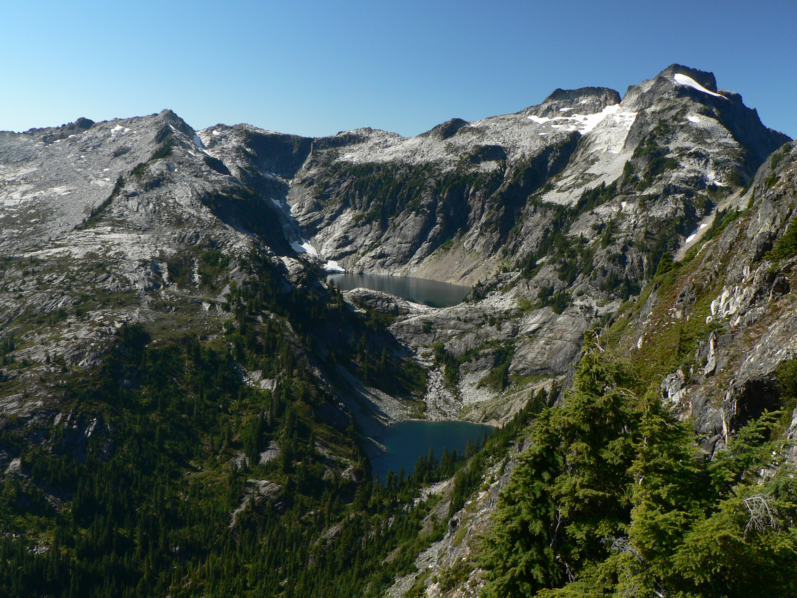
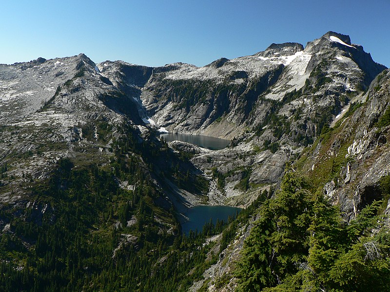
Upper
Thornton Lake, 5040 feet, 1536 m, Middle Thornton Lake, 4700 feet, 1433 m; Mountain Hemlock (lower right foreground)
78:
1434:
1186:
1037:
1000:
966:
929:
900:
873:
829:
793:
687:
401:
723:
651:
1449:
1071:
1344:
456:
1334:
1163:
Upper
Thornton Lake, 5040 feet, 1536 m, Middle Thornton Lake, 4700 feet, 1433 m}} |Source = Own work |Date =
312:
1465:
If the file has been modified from its original state, some details may not fully reflect the modified file.
300:
1671:
1339:
560:
501:– If you remix, transform, or build upon the material, you must distribute your contributions under the
1364:
204:
557:
453:
1314:
866:"}},"text\/plain":{"en":{"P7787":"270 degree"}}}}": -->
1707:
1159:== Summary == '''Thornton Lakes''' {{Information |Description = {{en|
1324:
118:
225:
1820:
1329:
383:
1592:
1244:
516:
394:
Permission is granted to copy, distribute and/or modify this document under the terms of the
1191:
1304:
1141:
1136:
69:
42:
1319:
218:
1196:
1181:
1160:
1152:
286:
153:
1775:
1689:
1491:
380:
I, the copyright holder of this work, hereby publish it under the following licenses:
105:
1409:
1830:
1785:
1531:
1234:
1374:
174:
163:
1725:
1511:
1294:
270:
1424:
1309:
1474:
1399:
1840:
1501:
1264:
1164:
235:
1484:
1419:
1229:
321:
1274:
1109:
Click on a date/time to view the file as it appeared at that time.
1444:
1254:
272:
257:
48° 41′ 13.92″ N, 121° 19′ 19.2″ W
1284:
515:
This licensing tag was added to this file as part of the GFDL
430:
247:
93:
1379:
1224:
635:
Add a one-line explanation of what this file represents
1335:
Wikipédia:Lumière sur/Parc national des North
Cascades
83:(2,560 × 1,920 pixels, file size: 1.76 MB, MIME type:
774:
740:
Creative
Commons Attribution-ShareAlike 3.0 Unported
400:, Version 1.2 or any later version published by the
142:
117:
Commons is a freely licensed media file repository.
1345:Wikipédia:Sélection/États-Unis/Articles de qualité
1712:Flash did not fire, compulsory flash suppression
1365:Nacionalni parkovi Sjedinjenih Američkih Država
522:http://creativecommons.org/licenses/by-sa/3.0/
98:
1315:Wikipédia:Sélection/Conservation de la nature
543:
435:
8:
528:Creative Commons Attribution-Share Alike 3.0
863:
598:https://creativecommons.org/licenses/by/2.5
574:– to copy, distribute and transmit the work
478:– to copy, distribute and transmit the work
177:, une montagne de 1433m d'altitude aux USA.
1467:
1111:
631:
616:You may select the license of your choice.
1207:The following other wikis use this file:
1305:Liste des parcs nationaux des États-Unis
757:Creative Commons Attribution 2.5 Generic
1848:
1838:
1828:
1818:
1810:
1802:
1794:
1783:
1773:
1765:
1757:
1749:
1741:
1733:
1723:
1715:
1705:
1697:
1687:
1679:
1669:
1661:
1640:
1632:
1621:
1613:
1605:
1597:
1587:
1579:
1571:
1563:
1555:
1547:
1539:
1528:
1520:
1509:
1499:
1489:
1479:
1340:Wikipédia:Sélection/États-Unis/Par État
1179:
1085:
1069:
1051:
1035:
1014:
998:
980:
964:
943:
927:
887:
871:
843:
827:
807:
791:
771:
754:
737:
721:
701:
685:
665:
649:
646:
627:
620:
250:
214:
1235:Parc Nacional de les Cascades del Nord
279:View this and other nearby images on:
1469:
1325:Wikipédia:Sélection/Washington (État)
1177:The following 4 pages use this file:
311:Thornton Lakes, Trappers Peak Trail,
7:
1375:Parco nazionale delle North Cascades
1215:قائمة حدائق الولايات المتحدة الوطنية
457:Attribution-Share Alike 3.0 Unported
412:http://www.gnu.org/copyleft/fdl.html
1100:
549:
446:
441:
1460:
1435:Danh sách vườn quốc gia tại Hoa Kỳ
1330:Wikipédia:Lumière sur/Février 2010
640:
634:
615:
565:
540:
379:
186:14 September 2007, 14:06:21 −07:00
168:
157:
130:
76:
639:
604:Creative Commons Attribution 2.5
1560:1,758.743 meters above sea level
1522:Date and time of data generation
1310:Parc national des North Cascades
874:coordinates of the point of view
625:
585:Under the following conditions:
556:This file is licensed under the
548:
542:
489:Under the following conditions:
452:This file is licensed under the
445:
440:
434:
388:
387:
285:
271:
263:
234:
224:
217:
97:
31:
21:
1400:Liste over nasjonalparker i USA
622:
158:
14:
621:
418:GNU Free Documentation License
407:GNU Free Documentation License
397:GNU Free Documentation License
169:
26:
1:
1754:A directly photographed image
1410:Zoznam národných parkov v USA
810:original creation by uploader
36:
1355:הפארק הלאומי צפון רכס קסקייד
1320:Wikipédia:Sélection/Amérique
1245:Národní park Severní Kaskády
1187:North Cascades National Park
647:Items portrayed in this file
313:North Cascades National Park
262:
1634:Date and time of digitizing
1425:North Cascades Ulusal Parkı
889:48°41'13.9"N, 121°19'19.2"W
1870:
1796:Focal length in 35 mm film
1738:One-chip color area sensor
1717:Supported Flashpix version
1441:Usage on zh.wikipedia.org
1431:Usage on vi.wikipedia.org
1416:Usage on tr.wikipedia.org
1406:Usage on sk.wikipedia.org
1396:Usage on no.wikipedia.org
1386:Usage on ka.wikipedia.org
1371:Usage on it.wikipedia.org
1361:Usage on hr.wikipedia.org
1351:Usage on he.wikipedia.org
1301:Usage on fr.wikipedia.org
1291:Usage on fo.wikipedia.org
1281:Usage on es.wikipedia.org
1271:Usage on eo.wikipedia.org
1261:Usage on de.wikipedia.org
1251:Usage on da.wikipedia.org
1241:Usage on cs.wikipedia.org
1221:Usage on ca.wikipedia.org
1211:Usage on ar.wikipedia.org
503:same or compatible license
358:Focal Length In 35mm Film:
1642:Meaning of each component
1599:File change date and time
1230:Servei de Parcs Nacionals
1101:
461:
433:
194:
16:
1637:14:06, 14 September 2007
1602:14:06, 14 September 2007
1525:14:06, 14 September 2007
1165:2007:09:14T14:06:21-7.00
1137:18:35, 22 September 2007
624:
402:Free Software Foundation
148:Thornton Lakes 25932.JPG
104:This is a file from the
1759:Custom image processing
1390:აშშ-ის ეროვნული პარკები
1265:Nördliche Kaskadenkette
1158:
846:Panasonic Lumix DMC-FZ5
561:Attribution 2.5 Generic
210:
200:
190:
185:
182:
145:
108:. Information from its
1663:Image compression mode
1275:Naciaj parkoj de Usono
370:©2007 Walter Siegmund
291:48.687200; -121.322000
111:description page there
46:Size of this preview:
1681:Maximum land aperture
1573:Horizontal resolution
1445:User:Fferic/Testpage3
1746:Digital still camera
1255:Nationalparker i USA
318:Viewpoint elevation:
70:2,560 × 1,920 pixels
1607:Y and C positioning
1581:Vertical resolution
1496:1/160 sec (0.00625)
1471:Camera manufacturer
580:– to adapt the work
484:– to adapt the work
309:Viewpoint location:
52:Other resolutions:
1804:Scene capture type
1780:Auto white balance
1295:Tjóðarlundir í USA
1285:Cascadas del Norte
66:1,280 × 960 pixels
62:1,024 × 768 pixels
1857:
1856:
1552:121° 19′ 19.15″ W
1203:Global file usage
1170:
865:
724:copyright license
633:
539:
538:
429:
428:
364:ISO Speed Rating:
336:Panasonic DMC-FZ5
296:
295:
245:
244:
154:Tsuga mertensiana
126:
125:
106:Wikimedia Commons
32:Global file usage
1861:
1615:Exposure Program
1468:
1420:Paternoster gölü
1192:Paternoster lake
1167:|Author = [[:en:
1149:
1019:
948:
911:
910:
905:
688:copyright status
611:
608:
605:
602:
599:
558:Creative Commons
552:
551:
546:
545:
535:
532:
529:
526:
523:
520:
517:licensing update
505:as the original.
454:Creative Commons
449:
448:
444:
443:
438:
437:
431:
425:
422:
419:
416:
413:
391:
390:
384:
292:
289:
275:
274:
268:
267:
266:
260:
259:
248:
238:
228:
221:
196:
173:
171:Français :
162:
149:
143:
122:
101:
100:
94:
88:
86:
73:
58:640 × 480 pixels
54:320 × 240 pixels
48:800 × 600 pixels
1869:
1868:
1864:
1863:
1862:
1860:
1859:
1858:
1850:GPS tag version
1684:3 APEX (f/2.83)
1544:48° 41′ 13.9″ N
1456:
1201:
1171:
1155:
1147:
1103:
1102:
1099:
1098:
1097:
1096:
1095:
1094:
1093:
1092:
1090:
1078:
1077:
1076:
1074:
1063:
1062:
1061:
1060:
1059:
1058:
1057:
1056:
1054:
1044:
1043:
1042:
1040:
1029:
1028:
1027:
1026:
1025:
1024:
1023:
1022:
1020:
1017:
1007:
1006:
1005:
1003:
992:
991:
990:
989:
988:
987:
986:
985:
983:
973:
972:
971:
969:
958:
957:
956:
955:
954:
953:
952:
951:
949:
946:
936:
935:
934:
932:
921:
920:
919:
918:
917:
916:
915:
914:
913:
912:
908:
906:
903:
894:
893:
892:
890:
880:
879:
878:
876:
857:
856:
855:
854:
853:
852:
851:
850:
848:
836:
835:
834:
832:
821:
820:
819:
818:
817:
816:
815:
814:
812:
800:
799:
798:
796:
785:
784:
783:
782:
781:
780:
779:
778:
776:
765:
764:
763:
762:
761:
759:
748:
747:
746:
745:
744:
742:
730:
729:
728:
726:
715:
714:
713:
712:
711:
710:
709:
708:
706:
694:
693:
692:
690:
679:
678:
677:
676:
675:
674:
673:
672:
670:
658:
657:
656:
654:
638:
637:
636:
619:
618:
617:
613:
612:
609:
606:
603:
600:
597:
596:
564:
553:
533:
530:
527:
524:
521:
514:
423:
420:
417:
414:
411:
382:
381:
376:
328:View direction:
290:
264:
255:
254:
251:Camera location
246:
239:
230:
222:
205:Walter Siegmund
178:
167:
147:
135:
128:
127:
116:
115:
114:is shown below.
90:
84:
82:
75:
74:
51:
12:
11:
5:
1867:
1865:
1855:
1854:
1851:
1847:
1846:
1843:
1837:
1836:
1833:
1827:
1826:
1823:
1817:
1816:
1813:
1809:
1808:
1805:
1801:
1800:
1797:
1793:
1792:
1789:
1782:
1781:
1778:
1772:
1771:
1768:
1764:
1763:
1762:Normal process
1760:
1756:
1755:
1752:
1748:
1747:
1744:
1740:
1739:
1736:
1735:Sensing method
1732:
1731:
1728:
1722:
1721:
1718:
1714:
1713:
1710:
1704:
1703:
1700:
1696:
1695:
1692:
1686:
1685:
1682:
1678:
1677:
1674:
1668:
1667:
1664:
1660:
1659:
1658:
1657:
1656:does not exist
1654:
1651:
1648:
1643:
1639:
1638:
1635:
1631:
1630:
1627:
1620:
1619:
1618:Normal program
1616:
1612:
1611:
1608:
1604:
1603:
1600:
1596:
1595:
1590:
1586:
1585:
1582:
1578:
1577:
1574:
1570:
1569:
1566:
1562:
1561:
1558:
1554:
1553:
1550:
1546:
1545:
1542:
1538:
1537:
1534:
1527:
1526:
1523:
1519:
1518:
1515:
1508:
1507:
1504:
1498:
1497:
1494:
1488:
1487:
1482:
1478:
1477:
1472:
1459:
1455:
1454:
1453:
1452:
1447:
1439:
1438:
1437:
1429:
1428:
1427:
1422:
1414:
1413:
1412:
1404:
1403:
1402:
1394:
1393:
1392:
1384:
1383:
1382:
1380:North Cascades
1377:
1369:
1368:
1367:
1359:
1358:
1357:
1349:
1348:
1347:
1342:
1337:
1332:
1327:
1322:
1317:
1312:
1307:
1299:
1298:
1297:
1289:
1288:
1287:
1279:
1278:
1277:
1269:
1268:
1267:
1259:
1258:
1257:
1249:
1248:
1247:
1239:
1238:
1237:
1232:
1227:
1219:
1218:
1217:
1205:
1204:
1200:
1199:
1197:User:Dmadeo/NP
1194:
1189:
1184:
1182:North Cascades
1175:
1174:
1169:
1168:
1161:Thornton Lakes
1157:
1153:
1150:
1146:2,560 × 1,920
1144:
1139:
1134:
1130:
1129:
1126:
1123:
1120:
1117:
1114:
1107:
1106:
1091:
1086:
1084:
1083:
1082:
1081:
1080:
1079:
1075:
1070:
1068:
1067:
1066:
1065:
1064:
1055:
1052:
1050:
1049:
1048:
1047:
1046:
1045:
1041:
1036:
1034:
1033:
1032:
1031:
1030:
1021:
1015:
1013:
1012:
1011:
1010:
1009:
1008:
1004:
999:
997:
996:
995:
994:
993:
984:
981:
979:
978:
977:
976:
975:
974:
970:
965:
963:
962:
961:
960:
959:
950:
944:
942:
941:
940:
939:
938:
937:
933:
928:
926:
925:
924:
923:
922:
899:
898:
897:
896:
895:
891:
888:
886:
885:
884:
883:
882:
881:
877:
872:
870:
869:
868:
867:
861:
849:
844:
842:
841:
840:
839:
838:
837:
833:
828:
826:
825:
824:
823:
822:
813:
808:
806:
805:
804:
803:
802:
801:
797:
794:source of file
792:
790:
789:
788:
787:
786:
777:
772:
770:
769:
768:
767:
766:
760:
755:
753:
752:
751:
750:
749:
743:
738:
736:
735:
734:
733:
732:
731:
727:
722:
720:
719:
718:
717:
716:
707:
702:
700:
699:
698:
697:
696:
695:
691:
686:
684:
683:
682:
681:
680:
671:
668:subalpine zone
666:
664:
663:
662:
661:
660:
659:
655:
650:
648:
645:
644:
643:
642:
641:
630:
629:
626:
623:
614:
595:
594:
593:
592:
583:
582:
581:
575:
568:You are free:
555:
554:
541:
537:
536:
511:
510:
509:
508:
507:
506:
496:
487:
486:
485:
479:
472:You are free:
467:
466:
463:
462:
460:
450:
427:
426:
392:
378:
377:
375:
372:
368:
367:
361:
355:
349:
343:
340:Exposure Time:
337:
331:
325:
315:
306:
301:Location Datum
294:
293:
283:
277:
252:
243:
242:
241:
240:
233:
231:
223:
216:
212:
211:Other versions
208:
207:
202:
198:
197:
192:
188:
187:
184:
180:
179:
175:Thornton Lakes
164:Thornton Lakes
150:
141:
138:Thornton Lakes
134:
131:
129:
124:
123:
102:
92:
91:
45:
41:
40:
39:
34:
29:
24:
19:
13:
10:
9:
6:
4:
3:
2:
1866:
1852:
1849:
1844:
1842:
1839:
1834:
1832:
1829:
1824:
1822:
1819:
1814:
1812:Scene control
1811:
1806:
1803:
1798:
1795:
1790:
1787:
1784:
1779:
1777:
1776:White balance
1774:
1770:Auto exposure
1769:
1767:Exposure mode
1766:
1761:
1758:
1753:
1750:
1745:
1742:
1737:
1734:
1729:
1727:
1724:
1719:
1716:
1711:
1709:
1706:
1701:
1698:
1693:
1691:
1690:Metering mode
1688:
1683:
1680:
1675:
1673:
1672:Exposure bias
1670:
1665:
1662:
1655:
1652:
1649:
1646:
1645:
1644:
1641:
1636:
1633:
1628:
1625:
1622:
1617:
1614:
1609:
1606:
1601:
1598:
1594:
1591:
1589:Software used
1588:
1583:
1580:
1575:
1572:
1567:
1564:
1559:
1556:
1551:
1548:
1543:
1540:
1535:
1533:
1529:
1524:
1521:
1516:
1513:
1510:
1505:
1503:
1500:
1495:
1493:
1492:Exposure time
1490:
1486:
1483:
1480:
1476:
1473:
1470:
1466:
1463:
1457:
1451:
1448:
1446:
1443:
1442:
1440:
1436:
1433:
1432:
1430:
1426:
1423:
1421:
1418:
1417:
1415:
1411:
1408:
1407:
1405:
1401:
1398:
1397:
1395:
1391:
1388:
1387:
1385:
1381:
1378:
1376:
1373:
1372:
1370:
1366:
1363:
1362:
1360:
1356:
1353:
1352:
1350:
1346:
1343:
1341:
1338:
1336:
1333:
1331:
1328:
1326:
1323:
1321:
1318:
1316:
1313:
1311:
1308:
1306:
1303:
1302:
1300:
1296:
1293:
1292:
1290:
1286:
1283:
1282:
1280:
1276:
1273:
1272:
1270:
1266:
1263:
1262:
1260:
1256:
1253:
1252:
1250:
1246:
1243:
1242:
1240:
1236:
1233:
1231:
1228:
1226:
1223:
1222:
1220:
1216:
1213:
1212:
1210:
1209:
1208:
1202:
1198:
1195:
1193:
1190:
1188:
1185:
1183:
1180:
1178:
1172:
1166:
1162:
1156:
1151:
1145:
1143:
1140:
1138:
1135:
1132:
1131:
1127:
1124:
1121:
1118:
1115:
1113:
1112:
1110:
1104:
1089:
1073:
1039:
1002:
968:
931:
930:exposure time
902:
875:
847:
831:
830:captured with
811:
795:
775:
758:
741:
725:
705:
689:
669:
653:
590:
587:
586:
584:
579:
576:
573:
570:
569:
567:
566:
562:
559:
547:
518:
513:
512:
504:
500:
497:
494:
491:
490:
488:
483:
480:
477:
474:
473:
471:
470:
469:
468:
465:
464:
458:
455:
451:
439:
432:
409:
408:
403:
399:
398:
393:
386:
385:
373:
371:
365:
362:
359:
356:
353:
352:Focal Length:
350:
347:
344:
341:
338:
335:
332:
329:
326:
323:
319:
316:
314:
310:
307:
304:
302:
298:
297:
288:
284:
282:
281:OpenStreetMap
278:
276:
258:
253:
249:
237:
232:
227:
220:
215:
213:
209:
206:
203:
199:
193:
189:
181:
176:
172:
165:
161:
156:
155:
151:
144:
140:
139:
132:
120:
113:
112:
107:
103:
96:
95:
89:
80:
79:Original file
71:
67:
63:
59:
55:
49:
44:
38:
35:
33:
30:
28:
25:
23:
20:
18:
15:
1786:Digital zoom
1699:Light source
1532:focal length
1481:Camera model
1464:
1461:
1225:Circ glacial
1206:
1176:
1108:
1105:File history
1001:focal length
588:
577:
571:
525:CC BY-SA 3.0
498:
492:
481:
475:
405:
395:
369:
363:
357:
351:
345:
339:
333:
327:
317:
308:
299:
261:
170:
159:
152:
137:
136:
119:You can help
109:
77:
22:File history
1743:File source
1726:Color space
1565:Orientation
1072:instance of
704:copyrighted
589:attribution
499:share alike
493:attribution
146:Description
1831:Saturation
1751:Scene type
1173:File usage
1122:Dimensions
1088:photograph
1018:millimetre
601:CC BY 2.5
85:image/jpeg
27:File usage
1841:Sharpness
1593:Ver.1.0
1549:Longitude
1512:ISO speed
1475:Panasonic
1154:Wsiegmund
1148:(1.76 MB)
1119:Thumbnail
1116:Date/Time
1038:ISO speed
459:license.
374:Licensing
346:F Number:
324:(5770 ft)
160:English:
1821:Contrast
1807:Standard
1610:Co-sited
1557:Altitude
1541:Latitude
1502:F-number
1458:Metadata
1450:美国国家公园列表
967:f-number
945:0.00625
628:Captions
578:to remix
572:to share
563:license.
482:to remix
476:to share
195:Own work
37:Metadata
1853:0.0.2.2
1702:Unknown
1626:version
1485:DMC-FZ5
1133:current
1128:Comment
901:heading
860:heading
652:depicts
632:English
334:Camera:
133:Summary
81:
1845:Normal
1835:Normal
1825:Normal
1584:72 dpi
1576:72 dpi
1568:Normal
1514:rating
947:second
909:degree
864:degree
269:
229:
201:Author
191:Source
1799:36 mm
1788:ratio
1708:Flash
1676:−0.66
1530:Lens
348:f/4.0
342:1/160
322:meter
320:1759
305:WGS84
1815:None
1730:sRGB
1694:Spot
1624:Exif
1536:6 mm
1125:User
907:270
610:true
607:true
534:true
531:true
424:true
421:true
415:GFDL
330:West
183:Date
17:File
1629:2.2
1506:f/4
354:6.0
1653:Cr
1650:Cb
1517:80
1053:80
1016:6
904::
366:80
360:36
68:|
64:|
60:|
56:|
50:.
1791:0
1720:1
1666:4
1647:Y
982:4
519:.
410:.
303::
121:.
87:)
72:.
Text is available under the Creative Commons Attribution-ShareAlike License. Additional terms may apply.

