183:
290:
129:
43:
351:
365:
653:
252:
91:
342:
670:{{Information |Description={{en|1=Thornhill, State Road 21, Talladega vicinity (Talladega County, Alabama) cropped {{PD-USGov-Interior-HABS|ALA,61-TALA.V,1-1}} }} |Source=http://memory.loc.gov/pnp/habshaer/al/al0700/al0763/photos/006962pv.jpg |Author=Alex
57:
53:
47:
70:
102:
689:
196:. These are programs of the National Park Service established for the purpose of documenting historic places. Records consist of measured drawings, archival photographs, and written reports.
770:
652:
647:
61:
42:
267:
727:
136:
263:
208:
192:
Historic
American Buildings Survey (HABS), Historic American Engineering Record (HAER) or Historic American Landscapes Survey (HALS)
190:
717:
493:
422:
358:
699:
684:
215:
750:
This file contains additional information, probably added from the digital camera or scanner used to create or digitize it.
598:
458:
582:
548:
471:
442:
514:
486:
406:
478:
753:
If the file has been modified from its original state, some details may not fully reflect the modified file.
317:
259:
694:
110:
177:
663:
364:
272:
145:
97:
348:
307:
123:
718:
Liste der Einträge im
National Register of Historic Places im Talladega County
281:
163:
Thornhill, State Road 21, Talladega vicinity (Talladega County, Alabama).jpg
690:
National
Register of Historic Places listings in Talladega County, Alabama
201:
Library of
Congress, Prints & Photographs Division, ALA,61-TALA.V,1-1
173:
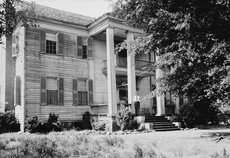
Thornhill, State Road 21, Talladega vicinity (Talladega County, Alabama)
318:
http://memory.loc.gov/pnp/habshaer/al/al0700/al0763/photos/006962pv.jpg
205:
This tag does not indicate the copyright status of the attached work.
620:
Click on a date/time to view the file as it appeared at that time.
262:
employee, created as part of that person's official duties. As a
140:
541:
350:
258:
This image or media file contains material based on a work of a
333:
246:
135:
This is an image of a place or building that is listed on the
85:
288:
343:
33° 24′ 06″ N, 86° 08′ 27″ W
390:
Add a one-line explanation of what this file represents
277:
737:
157:
109:
Commons is a freely licensed media file repository.
494:
work of the federal government of the United States
75:(913 × 626 pixels, file size: 230 KB, MIME type:
771:Microsoft Windows Photo Gallery 6.0.6001.18000
90:
8:
755:
622:
386:
226:
710:The following other wikis use this file:
783:
775:
765:
757:
682:
596:
580:
562:
546:
528:
512:
456:
440:
420:
404:
401:
382:
375:
336:
357:View this and other nearby images on:
680:The following 4 pages use this file:
251:
7:
137:National Register of Historic Places
611:
191:
189:
748:
395:
389:
167:
122:
68:
394:
788:C551CD88D7294D768B8C80BD2076734F
380:
363:
349:
250:
181:
127:
89:
31:
21:
377:
168:
14:
700:Thornhill (Talladega, Alabama)
685:List of plantations in Alabama
376:
276:in the United States. See the
26:
1:
549:coordinates of depicted place
36:
564:33°24'6.001"N, 86°8'26.999"W
402:Items portrayed in this file
199:When reusing please credit:
805:
734:Usage on www.wikidata.org
724:Usage on uk.wikipedia.org
714:Usage on de.wikipedia.org
143:. Its reference number is
777:File change date and time
612:
188:This file comes from the
16:
479:United States of America
379:
141:United States of America
96:This is a file from the
780:07:35, 11 December 2010
669:
648:12:38, 11 December 2010
472:applies to jurisdiction
327:Alex Bush, Photographer
323:
313:
306:
303:
268:U.S. federal government
160:
100:. Information from its
369:33.401667; -86.140833
293:
270:, such work is in the
103:description page there
46:Size of this preview:
292:
284:for more information.
260:National Park Service
583:location of creation
487:determination method
282:NPS copyright policy
728:Талладіга (Алабама)
52:Other resolutions:
695:Talladega, Alabama
294:
211:is still required.
792:
791:
706:Global file usage
673:
388:
374:
373:
331:
330:
298:
297:
245:
244:
225:
224:
220:
216:Commons:Licensing
155:
154:
118:
117:
98:Wikimedia Commons
32:Global file usage
796:
756:
660:
599:Talladega County
496:
491:
481:
476:
443:copyright status
370:
367:
353:
352:
346:
345:
334:
309:
291:
254:
253:
247:
241:
238:
235:
232:
227:
219:
212:
204:
195:
193:
185:
184:
178:
172:
164:
158:
148:
131:
130:
124:
114:
93:
92:
86:
80:
78:
65:
62:913 × 626 pixels
58:640 × 439 pixels
54:320 × 219 pixels
48:800 × 549 pixels
804:
803:
799:
798:
797:
795:
794:
793:
785:Unique image ID
744:
704:
674:
666:
658:
614:
613:
610:
609:
608:
607:
606:
605:
604:
603:
601:
589:
588:
587:
585:
574:
573:
572:
571:
570:
569:
568:
567:
565:
555:
554:
553:
551:
540:
539:
538:
537:
536:
535:
534:
533:
531:
521:
520:
519:
517:
506:
505:
504:
503:
502:
501:
500:
499:
498:
497:
492:
489:
483:
482:
477:
474:
465:
464:
463:
461:
449:
448:
447:
445:
434:
433:
432:
431:
430:
429:
428:
427:
425:
413:
412:
411:
409:
393:
392:
391:
368:
341:
340:
337:Object location
332:
299:
289:
239:
236:
233:
230:
213:
206:
182:
162:
144:
128:
120:
119:
108:
107:
106:is shown below.
82:
76:
74:
67:
66:
51:
12:
11:
5:
802:
800:
790:
789:
786:
782:
781:
778:
774:
773:
768:
764:
763:
760:
747:
743:
742:
741:
740:
732:
731:
730:
722:
721:
720:
708:
707:
703:
702:
697:
692:
687:
678:
677:
672:
671:
668:
664:
661:
655:
650:
645:
641:
640:
637:
634:
631:
628:
625:
618:
617:
602:
597:
595:
594:
593:
592:
591:
590:
586:
581:
579:
578:
577:
576:
575:
566:
563:
561:
560:
559:
558:
557:
556:
552:
547:
545:
544:
543:
542:
532:
529:
527:
526:
525:
524:
523:
522:
518:
513:
511:
510:
509:
508:
507:
485:
484:
470:
469:
468:
467:
466:
462:
457:
455:
454:
453:
452:
451:
450:
446:
441:
439:
438:
437:
436:
435:
426:
421:
419:
418:
417:
416:
415:
414:
410:
405:
403:
400:
399:
398:
397:
396:
385:
384:
381:
378:
372:
371:
361:
355:
338:
329:
328:
325:
321:
320:
315:
311:
310:
305:
301:
300:
296:
295:
286:
255:
243:
242:
223:
222:
186:
165:
156:
153:
152:
132:
121:
116:
115:
94:
84:
83:
45:
41:
40:
39:
34:
29:
24:
19:
13:
10:
9:
6:
4:
3:
2:
801:
787:
784:
779:
776:
772:
769:
767:Software used
766:
761:
758:
754:
751:
745:
739:
736:
735:
733:
729:
726:
725:
723:
719:
716:
715:
713:
712:
711:
705:
701:
698:
696:
693:
691:
688:
686:
683:
681:
675:
667:
662:
656:
654:
651:
649:
646:
643:
642:
638:
635:
632:
629:
626:
624:
623:
621:
615:
600:
584:
550:
516:
495:
488:
480:
473:
460:
459:public domain
444:
424:
408:
366:
362:
360:
359:OpenStreetMap
356:
354:
344:
339:
335:
326:
322:
319:
316:
312:
302:
287:
285:
283:
279:
275:
274:
273:public domain
269:
265:
261:
256:
249:
248:
234:Public domain
231:Public domain
229:
228:
221:
217:
210:
209:copyright tag
203:
202:
198:
194:
187:
180:
179:
176:
171:
166:
159:
151:
150:
147:
142:
138:
133:
126:
125:
112:
105:
104:
99:
95:
88:
87:
81:
72:
71:Original file
63:
59:
55:
49:
44:
38:
35:
33:
30:
28:
25:
23:
20:
18:
15:
752:
749:
709:
679:
619:
616:File history
271:
257:
200:
197:
174:
169:
134:
111:You can help
101:
69:
22:File history
759:Orientation
278:NPS website
161:Description
676:File usage
657:913 × 626
633:Dimensions
530:8 May 1935
308:8 May 1935
77:image/jpeg
27:File usage
738:Q22058580
665:KudzuVine
630:Thumbnail
627:Date/Time
515:inception
423:Thornhill
207:A normal
170:English:
746:Metadata
659:(230 KB)
383:Captions
175:cropped
146:98000104
37:Metadata
644:current
639:Comment
407:depicts
387:English
266:of the
139:in the
73:
762:Normal
347:
324:Author
314:Source
240:false
237:false
636:User
304:Date
280:and
264:work
214:See
17:File
490::
475::
60:|
56:|
50:.
218:.
149:.
113:.
79:)
64:.
Text is available under the Creative Commons Attribution-ShareAlike License. Additional terms may apply.

.jpg)
.jpg¶ms=033.401667_N_-086.140833_E_globe:Earth_class:object_region:US_type:landmark_scale:1500_&language=en)