374:
307:
257:
299:
249:
321:
271:
342:
380:
385:
67:
952:
850:"}},"text\/plain":{"en":{"":"heading"}}},"{\"value\":{\"amount\":\"+90\",\"unit\":\"http:\\\/\\\/www.wikidata.org\\\/entity\\\/Q28390\"},\"type\":\"quantity\"}":{"text\/html":{"en":{"P7787":"90
786:"}},"text\/plain":{"en":{"":"heading"}}},"{\"value\":{\"amount\":\"+90\",\"unit\":\"http:\\\/\\\/www.wikidata.org\\\/entity\\\/Q28390\"},\"type\":\"quantity\"}":{"text\/html":{"en":{"P7787":"90
782:
123:
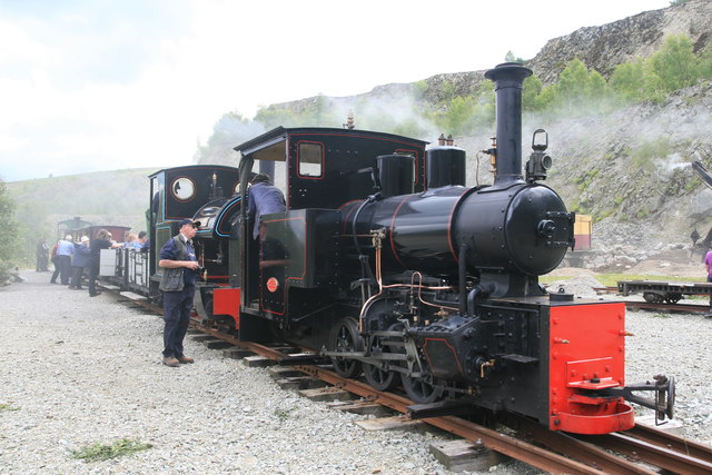
The steam gala was great fun and the atmosphere is hazy because of the smoke produced by no less than five locomotives and a steam excavator in the confines of the quarry floor at that time. This train had been hauled in by
Hudswell, Clarke No. 1238 and Stanhope from the Apedale Valley Light Railway
132:
Threlkeld Quarry, which is situated three miles east of
Keswick, originally opened in 1870 to supply railway ballast to the Penrith-Keswick line. Later, the stone was used by the Manchester Corporation Waterworks for their Thirlmere scheme, for railway ballast for the Crewe-Carlisle line, for
38:
135:
The extensive quarry site has ample space for the display of the unique collection of vintage excavators and old quarry machinery. The 2ft gauge mineral railway has been relaid and provides a ride into the inner quarry for visitors to view the quarry faces in
240:
46:
78:
432:– You must give appropriate credit, provide a link to the license, and indicate if changes were made. You may do so in any reasonable manner, but not in any way that suggests the licensor endorses you or your use.
133:
roadstone, kerbing and for facing buildings with dressed stone. The granite quarry finally closed in 1982 and is now the site for the
Threlkeld Quarry & Mining Museum which is run by a group of volunteers.
847:
783:
951:
946:
37:
177:
983:
684:
648:
612:
314:
264:
734:
349:
439:
575:
888:
861:
824:
797:
697:
668:
596:
568:
553:
540:
755:
727:
712:
632:
513:
496:
336:
395:
438:– If you remix, transform, or build upon the material, you must distribute your contributions under the
356:
on the
Geograph website for the photographer's contact details. The copyright on this image is owned by
392:
854:"}},"text\/plain":{"en":{"P7787":"90 degree"}}}}": -->
790:"}},"text\/plain":{"en":{"P7787":"90 degree"}}}}": -->
962:
86:
209:
719:
704:
560:
193:
320:
270:
361:
73:
254:
1001:
145:
304:
156:
166:
111:
Threlkeld Quarry & Mine Museum - passenger train (geograph 4586753).jpg
47:
Threlkeld_Quarry_&_Mine_Museum_-_passenger_train_(geograph_4586753).jpg
341:
353:
919:
Click on a date/time to view the file as it appeared at that time.
306:
256:
281:
241:
54° 36′ 30.42″ N, 3° 02′ 39.8″ W
231:
61:
291:
54° 36′ 30.6″ N, 3° 02′ 38″ W
124:
with Sir Tom, the site's indigenous engine, at the rear.
480:
Add a one-line explanation of what this file represents
121:
Threlkeld Quarry & Mine Museum - passenger train.
224:
Threlkeld Quarry & Mine Museum - passenger train
205:
Threlkeld Quarry & Mine Museum - passenger train
184:
Creative
Commons Attribution Share-alike license 2.0
105:
85:
Commons is a freely licensed media file repository.
649:
Creative
Commons Attribution-ShareAlike 2.0 Generic
51:(640 × 427 pixels, file size: 80 KB, MIME type:
449:https://creativecommons.org/licenses/by-sa/2.0
66:
455:Creative Commons Attribution-Share Alike 2.0
373:
8:
851:
787:
415:– to copy, distribute and transmit the work
921:
476:
994:The following other wikis use this file:
720:https://www.geograph.org.uk/photo/4586753
561:https://www.geograph.org.uk/profile/4264
981:
875:
859:
811:
795:
769:
753:
682:
666:
646:
630:
610:
594:
527:
511:
494:
491:
472:
465:
284:
234:
969:Transferred from geograph.co.uk using
313:View this and other nearby images on:
263:View this and other nearby images on:
7:
360:and is licensed for reuse under the
979:The following page uses this file:
910:
396:Attribution-Share Alike 2.0 Generic
384:
379:
364:Attribution-ShareAlike 2.0 license.
1002:Threlkeld Quarry and Mining Museum
984:Threlkeld Quarry and Mining Museum
485:
479:
370:
347:
128:Threlkeld Quarry and Mining Museum
115:
98:
44:
484:
798:coordinates of the point of view
470:
426:Under the following conditions:
391:This file is licensed under the
383:
378:
372:
340:
319:
305:
297:
269:
255:
247:
65:
31:
21:
467:
116:
41:No higher resolution available.
14:
685:file available on the internet
466:
348:This image was taken from the
26:
1:
862:coordinates of depicted place
813:54°36'30.424"N, 3°2'39.804"W
735:Geograph Britain and Ireland
569:object of statement has role
492:Items portrayed in this file
296:
246:
1020:
998:Usage on de.wikipedia.org
877:54°36'30.60"N, 3°2'38.40"W
440:same or compatible license
911:
16:
698:geograph.org.uk image ID
469:
406:
222:Chris Allen /
203:Chris Allen /
72:This is a file from the
968:
947:07:07, 27 February 2016
194:required by the license
172:
162:
151:
144:
141:
108:
76:. Information from its
354:this photograph's page
325:54.608500; -3.044000
275:54.608451; -3.044390
79:description page there
421:– to adapt the work
541:author name string
990:Global file usage
972:
853:
789:
633:copyright license
478:
369:
368:
352:collection. See
330:
329:
280:
279:
229:
228:
197:
181:
178:Reusing this file
94:
93:
74:Wikimedia Commons
32:Global file usage
1011:
959:
899:
898:
893:
835:
834:
829:
737:
732:
722:
717:
713:described at URL
707:
702:
597:copyright status
578:
573:
563:
558:
548:
545:
462:
459:
456:
453:
450:
442:as the original.
404:
393:Creative Commons
387:
386:
382:
381:
376:
375:
362:Creative Commons
350:Geograph project
344:
337:
326:
323:
309:
308:
302:
301:
300:
294:
293:
282:
276:
273:
259:
258:
252:
251:
250:
244:
243:
232:
191:
175:
147:
120:
112:
106:
90:
69:
68:
62:
56:
54:
1019:
1018:
1014:
1013:
1012:
1010:
1009:
1008:
988:
973:
965:
957:
913:
912:
909:
908:
907:
906:
905:
904:
903:
902:
901:
900:
896:
894:
891:
882:
881:
880:
878:
868:
867:
866:
864:
845:
844:
843:
842:
841:
840:
839:
838:
837:
836:
832:
830:
827:
818:
817:
816:
814:
804:
803:
802:
800:
781:
780:
779:
778:
777:
776:
775:
774:
772:
762:
761:
760:
758:
747:
746:
745:
744:
743:
742:
741:
740:
739:
738:
733:
730:
724:
723:
718:
715:
709:
708:
703:
700:
691:
690:
689:
687:
675:
674:
673:
671:
660:
659:
658:
657:
656:
655:
654:
653:
651:
639:
638:
637:
635:
624:
623:
622:
621:
620:
619:
618:
617:
615:
603:
602:
601:
599:
588:
587:
586:
585:
584:
583:
582:
581:
580:
579:
574:
571:
565:
564:
559:
556:
550:
549:
546:
543:
534:
533:
532:
530:
520:
519:
518:
516:
505:
504:
503:
502:
501:
499:
483:
482:
481:
464:
463:
460:
457:
454:
451:
448:
447:
405:
402:
399:
388:
365:
335:
324:
298:
289:
288:
285:Object location
274:
248:
239:
238:
235:Camera location
230:
219:
212:
200:
157:geograph.org.uk
137:
130:
110:
103:
96:
95:
84:
83:
82:is shown below.
58:
52:
50:
43:
42:
12:
11:
5:
1017:
1015:
1007:
1006:
1005:
1004:
992:
991:
987:
986:
977:
976:
971:
970:
967:
963:
960:
954:
949:
944:
940:
939:
936:
933:
930:
927:
924:
917:
916:
887:
886:
885:
884:
883:
879:
876:
874:
873:
872:
871:
870:
869:
865:
860:
858:
857:
856:
855:
849:
823:
822:
821:
820:
819:
815:
812:
810:
809:
808:
807:
806:
805:
801:
796:
794:
793:
792:
791:
785:
773:
770:
768:
767:
766:
765:
764:
763:
759:
754:
752:
751:
750:
749:
748:
726:
725:
711:
710:
696:
695:
694:
693:
692:
688:
683:
681:
680:
679:
678:
677:
676:
672:
669:source of file
667:
665:
664:
663:
662:
661:
652:
647:
645:
644:
643:
642:
641:
640:
636:
631:
629:
628:
627:
626:
625:
616:
611:
609:
608:
607:
606:
605:
604:
600:
595:
593:
592:
591:
590:
589:
567:
566:
552:
551:
539:
538:
537:
536:
535:
531:
528:
526:
525:
524:
523:
522:
521:
517:
512:
510:
509:
508:
507:
506:
500:
495:
493:
490:
489:
488:
487:
486:
475:
474:
471:
468:
446:
445:
444:
443:
433:
424:
423:
422:
416:
409:You are free:
400:
390:
389:
371:
367:
366:
345:
334:
331:
328:
327:
317:
311:
286:
278:
277:
267:
261:
236:
227:
226:
220:
217:
214:
213:
208:
201:
198:
186:
185:
182:
170:
169:
164:
160:
159:
153:
149:
148:
143:
139:
138:
129:
126:
113:
104:
102:
99:
97:
92:
91:
70:
60:
59:
40:
36:
35:
34:
29:
24:
19:
13:
10:
9:
6:
4:
3:
2:
1016:
1003:
1000:
999:
997:
996:
995:
989:
985:
982:
980:
974:
966:
964:NearEMPTiness
961:
955:
953:
950:
948:
945:
942:
941:
937:
934:
931:
928:
925:
923:
922:
920:
914:
890:
863:
826:
799:
757:
736:
729:
721:
714:
706:
699:
686:
670:
650:
634:
614:
598:
577:
570:
562:
555:
542:
515:
498:
452:CC BY-SA 2.0
441:
437:
434:
431:
428:
427:
425:
420:
417:
414:
411:
410:
408:
407:
401:Attribution:
397:
394:
377:
363:
359:
355:
351:
346:
343:
339:
338:
332:
322:
318:
316:
315:OpenStreetMap
312:
310:
292:
287:
283:
272:
268:
266:
265:OpenStreetMap
262:
260:
242:
237:
233:
225:
221:
216:
215:
211:
207: /
206:
202:
195:
190:
188:
187:
183:
179:
174:
171:
168:
165:
161:
158:
154:
150:
140:
134:
127:
125:
119:
114:
107:
100:
88:
81:
80:
75:
71:
64:
63:
57:
48:
39:
33:
30:
28:
25:
23:
20:
18:
15:
993:
978:
918:
915:File history
771:25 July 2015
576:photographer
435:
429:
418:
412:
357:
295:
245:
223:
210:CC BY-SA 2.0
204:
146:25 July 2015
131:
122:
117:
87:You can help
77:
45:
22:File history
613:copyrighted
547:Chris Allen
436:share alike
430:attribution
403:Chris Allen
358:Chris Allen
189:Attribution
167:Chris Allen
109:Description
975:File usage
956:640 × 427
932:Dimensions
529:some value
173:Permission
53:image/jpeg
27:File usage
929:Thumbnail
926:Date/Time
756:inception
333:Licensing
218:InfoField
199:InfoField
118:English:
728:operator
473:Captions
419:to remix
413:to share
398:license.
958:(80 KB)
943:current
938:Comment
889:heading
848:heading
825:heading
784:heading
705:4586753
514:creator
497:depicts
477:English
136:safety.
101:Summary
49:
897:degree
852:degree
833:degree
788:degree
303:
253:
163:Author
152:Source
155:From
935:User
461:true
458:true
142:Date
17:File
895:90
831:90
554:URL
892::
828::
731::
716::
701::
572::
557::
544::
196:)
192:(
180:)
176:(
89:.
55:)
Text is available under the Creative Commons Attribution-ShareAlike License. Additional terms may apply.
.jpg)
.jpg¶ms=054.608451_N_-003.044390_E_globe:Earth_type:camera_heading:90.00_source:geograph&language=en)
.jpg¶ms=054.608500_N_-003.044000_E_globe:Earth_class:object_type:object_source:geograph-osgb36(NY32662420)_region:GB-GBN_heading:90.00&language=en)
