43:
289:
267:
237:
295:
300:
91:
728:
698:
668:
638:
1306:
341:– You must give appropriate credit, provide a link to the license, and indicate if changes were made. You may do so in any reasonable manner, but not in any way that suggests the licensor endorses you or your use.
1273:
764:
1545:
1381:
1461:
1416:
435:== Summary == {{Information |Description=Outline map of the Trnava Region, Slovakia, ready for the ] template, calibrated at ] |Source=self-made |Date=2
415:== Summary == {{Information |Description=Background map of the Trnava Region, Slovakia, ready for the ] template, calibrated at ] |Source=Made my myself
1361:
149:
140:
57:
53:
47:
102:
1386:
70:
1366:
1301:
1466:
1406:
384:
191:
172:
1336:
549:
513:
1511:
423:
261:
200:
177:
1556:
This file contains additional information, probably added from the digital camera or scanner used to create or digitize it.
856:
776:
750:
727:
722:
697:
692:
667:
662:
348:
1106:
277:
1001:
497:
1016:
1481:
1476:
1251:
569:
533:
480:
1071:
816:
801:
986:
1436:
1086:
1146:
310:
1559:
If the file has been modified from its original state, some details may not fully reflect the modified file.
981:
763:
More than 100 pages use this file. The following list shows the first 100 pages that use this file only. A
1506:
1496:
1486:
1196:
1081:
786:
1471:
347:– If you remix, transform, or build upon the material, you must distribute your contributions under the
996:
966:
891:
1221:
746:
307:
1101:
1501:
1426:
1356:
1156:
1186:
956:
916:
881:
876:
637:
632:
61:
42:
110:
961:
951:
906:
886:
871:
826:
971:
946:
896:
861:
1536:
1521:
1456:
1446:
1431:
1396:
1391:
1341:
444:
214:
145:
136:
708:
678:
648:
1191:
255:, which means that it has been digitally altered from its original version. Modifications:
738:
866:
745:{{Information |Description=Background map of the Trnava Region, Slovakia, ready for the
247:
1531:
1526:
1516:
1441:
1411:
1401:
1376:
1351:
1321:
1311:
1296:
1291:
1241:
1236:
1226:
1091:
1096:
159:
97:
1266:
1246:
1231:
1026:
1011:
991:
831:
781:
272:
210:
1161:
1051:
976:
1451:
1421:
1201:
1166:
1116:
1061:
1056:
1021:
941:
911:
791:
266:
1261:
1256:
1036:
1006:
811:
806:
796:
771:
1171:
1151:
1121:
1076:
1046:
1031:
1491:
1371:
1346:
1331:
1326:
1316:
1211:
1181:
931:
901:
821:
430:
410:
400:
391:
204:
195:
236:
1206:
1136:
1131:
1111:
1041:
936:
846:
841:
1141:
921:
851:
836:
1176:
1126:
605:
Click on a date/time to view the file as it appeared at that time.
1216:
926:
753:
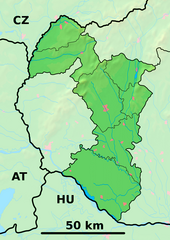
Outline map of the Trnava Region, Slovakia, ready for the [[:en:Te
1066:
230:
85:
135:
Background map of the Trnava Region, Slovakia, ready for the
144:
Outline map of the Trnava Region, Slovakia, ready for the
380:
This image is a derivative work of the following images:
464:
Add a one-line explanation of what this file represents
550:
Creative
Commons Attribution-ShareAlike 3.0 Unported
124:
109:
Commons is a freely licensed media file repository.
75:(880 × 1,240 pixels, file size: 684 KB, MIME type:
358:https://creativecommons.org/licenses/by-sa/3.0
90:
426:licensed with Cc-by-sa-3.0,2.5,2.0,1.0, GFDL
364:Creative Commons Attribution-Share Alike 3.0
288:
8:
655:Reverted to version as of 21:28, 25 May 2014
324:– to copy, distribute and transmit the work
1561:
607:
460:
1284:The following other wikis use this file:
751:en:Template:Geobox locator Trnava Region
259:. The original can be viewed here:
150:en:Template:Geobox locator Trnava Region
141:en:Template:Geobox locator Trnava Region
1579:
1571:
1563:
769:
583:
567:
547:
531:
511:
495:
478:
475:
456:
449:
385:File:Trnava_Region_-_background_map.png
7:
424:File:Trnava_Region_-_outline_map.svg
311:Attribution-Share Alike 3.0 Unported
596:
299:
294:
248:
246:
1554:
469:
463:
285:
192:Trnava_Region_-_background_map.png
173:Trnava_Region_-_background_map.png
122:
68:
1307:Шаблон:ПК Словакия Търнавски край
468:
454:
335:Under the following conditions:
306:This file is licensed under the
298:
293:
287:
265:
235:
130:Trnava Region - physical map.png
89:
31:
21:
451:
262:Trnava Region - outline map.svg
201:Trnava_Region_-_outline_map.svg
178:Trnava_Region_-_outline_map.svg
14:
450:
26:
1:
36:
476:Items portrayed in this file
857:Dobrá Voda, Trnava District
1601:
1288:Usage on bg.wikipedia.org
1107:Radošovce, Trnava District
349:same or compatible license
1581:File change date and time
1382:Радошовце (окръг Скалица)
1002:Jánovce, Galanta District
597:
433:1100x1550 (122371 Bytes)
16:
1087:Pavlice, Trnava District
1072:Oreské, Skalica District
777:Banka, Piešťany District
749:template, calibrated at
723:16:25, 27 September 2010
453:
413:880x1240 (919490 Bytes)
403:880x1240 (919490 Bytes)
394:880x1240 (916063 Bytes)
315:
271:. Modifications made by
160:27 September 2010, 16:18
148:template, calibrated at
139:template, calibrated at
96:This is a file from the
1462:Богдановце-над-Търнавоу
982:Hoste, Galanta District
817:Buková, Trnava District
802:Borová, Trnava District
744:
714:
684:
654:
387:licensed with PD-Demis
185:
166:
158:
155:
127:
100:. Information from its
1082:Pata, Galanta District
1017:Križovany nad Dudváhom
987:Hrnčiarovce nad Parnou
787:Bohdanovce nad Trnavou
103:description page there
46:Size of this preview:
1565:Horizontal resolution
1362:Добра вода (Словакия)
429:2007-10-27T19:50:33Z
409:2007-10-27T19:52:08Z
399:2007-10-27T20:25:24Z
390:2007-10-27T20:31:17Z
1417:Градиште под Вратном
1573:Vertical resolution
1387:Кути (окръг Сеница)
1197:Vinohrady nad Váhom
376:Original upload log
330:– to adapt the work
52:Other resolutions:
1584:21:23, 25 May 2014
1367:Скалица (Словакия)
1302:Търнава (Словакия)
1147:Slovenská Nová Ves
997:Jaslovské Bohunice
715:Trnava Region only
693:21:28, 25 May 2014
663:21:35, 25 May 2014
633:21:36, 25 May 2014
62:880 × 1,240 pixels
1588:
1587:
1546:more global usage
1467:Борова (Словакия)
1407:Сеница (Словакия)
1280:Global file usage
1222:Zeleneč, Slovakia
756:
585:27 September 2010
534:copyright license
462:
284:
283:
249:retouched picture
225:
224:
209:derivative work:
118:
117:
98:Wikimedia Commons
32:Global file usage
1592:
1562:
1512:Дълга (Словакия)
1157:Suchá nad Parnou
735:
705:
675:
645:
498:copyright status
371:
368:
365:
362:
359:
351:as the original.
308:Creative Commons
302:
301:
297:
296:
291:
290:
279:
269:
252:
250:
239:
231:
217:
161:
131:
125:
114:
93:
92:
86:
80:
78:
65:
58:340 × 480 pixels
54:170 × 240 pixels
48:425 × 599 pixels
1600:
1599:
1595:
1594:
1593:
1591:
1590:
1589:
1550:
1337:Дунайска Стреда
1278:
967:Horné Trhovište
962:Horné Otrokovce
907:Dunajská Streda
892:Dolné Trhovište
887:Dolné Otrokovce
827:Bílkove Humence
757:
741:
733:
711:
703:
681:
673:
651:
643:
599:
598:
595:
594:
593:
592:
591:
590:
589:
588:
586:
576:
575:
574:
572:
561:
560:
559:
558:
557:
556:
555:
554:
552:
540:
539:
538:
536:
525:
524:
523:
522:
521:
520:
519:
518:
516:
504:
503:
502:
500:
489:
488:
487:
486:
485:
483:
467:
466:
465:
405:fixed alignment
378:
373:
372:
369:
366:
363:
360:
357:
356:
314:
303:
240:
226:
215:
129:
120:
119:
108:
107:
106:is shown below.
82:
76:
74:
67:
66:
51:
12:
11:
5:
1598:
1596:
1586:
1585:
1582:
1578:
1577:
1574:
1570:
1569:
1566:
1553:
1548:of this file.
1542:
1541:
1540:
1539:
1534:
1529:
1524:
1519:
1514:
1509:
1504:
1499:
1494:
1489:
1484:
1479:
1474:
1469:
1464:
1459:
1454:
1449:
1444:
1439:
1434:
1429:
1424:
1419:
1414:
1409:
1404:
1399:
1394:
1389:
1384:
1379:
1374:
1369:
1364:
1359:
1354:
1349:
1344:
1339:
1334:
1329:
1324:
1319:
1314:
1309:
1304:
1299:
1294:
1282:
1281:
1276:to this file.
1270:
1269:
1264:
1259:
1254:
1249:
1244:
1239:
1234:
1229:
1227:Zemianske Sady
1224:
1219:
1214:
1209:
1204:
1199:
1194:
1189:
1184:
1179:
1174:
1169:
1164:
1159:
1154:
1149:
1144:
1139:
1134:
1129:
1124:
1119:
1114:
1109:
1104:
1099:
1094:
1089:
1084:
1079:
1074:
1069:
1064:
1059:
1054:
1049:
1044:
1039:
1034:
1029:
1024:
1019:
1014:
1009:
1004:
999:
994:
989:
984:
979:
974:
972:Horné Zelenice
969:
964:
959:
954:
949:
944:
939:
934:
929:
924:
919:
914:
909:
904:
899:
897:Dolné Zelenice
894:
889:
884:
879:
874:
869:
864:
859:
854:
849:
844:
839:
834:
829:
824:
819:
814:
809:
804:
799:
794:
789:
784:
779:
774:
767:is available.
761:
760:
755:
754:
743:
739:
736:
730:
725:
720:
717:
716:
713:
709:
706:
700:
695:
690:
687:
686:
683:
679:
676:
670:
665:
660:
657:
656:
653:
649:
646:
640:
635:
630:
626:
625:
622:
619:
616:
613:
610:
603:
602:
587:
584:
582:
581:
580:
579:
578:
577:
573:
568:
566:
565:
564:
563:
562:
553:
548:
546:
545:
544:
543:
542:
541:
537:
532:
530:
529:
528:
527:
526:
517:
512:
510:
509:
508:
507:
506:
505:
501:
496:
494:
493:
492:
491:
490:
484:
479:
477:
474:
473:
472:
471:
470:
459:
458:
455:
452:
443:Uploaded with
440:
439:
438:
437:
420:
419:
418:
417:
407:
397:
377:
374:
355:
354:
353:
352:
342:
333:
332:
331:
325:
318:You are free:
305:
304:
286:
282:
281:
241:
234:
223:
222:
221:
220:
207:
198:
187:
183:
182:
181:
180:
175:
168:
164:
163:
157:
153:
152:
132:
123:
121:
116:
115:
94:
84:
83:
45:
41:
40:
39:
34:
29:
24:
19:
13:
10:
9:
6:
4:
3:
2:
1597:
1583:
1580:
1575:
1572:
1567:
1564:
1560:
1557:
1551:
1549:
1547:
1538:
1535:
1533:
1530:
1528:
1525:
1523:
1520:
1518:
1515:
1513:
1510:
1508:
1505:
1503:
1500:
1498:
1495:
1493:
1490:
1488:
1485:
1483:
1482:Горне Орешани
1480:
1478:
1477:Долне Орешани
1475:
1473:
1470:
1468:
1465:
1463:
1460:
1458:
1455:
1453:
1450:
1448:
1445:
1443:
1440:
1438:
1435:
1433:
1430:
1428:
1425:
1423:
1420:
1418:
1415:
1413:
1410:
1408:
1405:
1403:
1400:
1398:
1395:
1393:
1390:
1388:
1385:
1383:
1380:
1378:
1375:
1373:
1370:
1368:
1365:
1363:
1360:
1358:
1355:
1353:
1350:
1348:
1345:
1343:
1340:
1338:
1335:
1333:
1330:
1328:
1325:
1323:
1320:
1318:
1315:
1313:
1310:
1308:
1305:
1303:
1300:
1298:
1295:
1293:
1290:
1289:
1287:
1286:
1285:
1279:
1277:
1275:
1268:
1265:
1263:
1260:
1258:
1255:
1253:
1252:Šaštín-Stráže
1250:
1248:
1245:
1243:
1240:
1238:
1235:
1233:
1230:
1228:
1225:
1223:
1220:
1218:
1215:
1213:
1210:
1208:
1205:
1203:
1200:
1198:
1195:
1193:
1190:
1188:
1185:
1183:
1180:
1178:
1175:
1173:
1170:
1168:
1165:
1163:
1160:
1158:
1155:
1153:
1150:
1148:
1145:
1143:
1140:
1138:
1135:
1133:
1130:
1128:
1125:
1123:
1120:
1118:
1115:
1113:
1110:
1108:
1105:
1103:
1100:
1098:
1095:
1093:
1090:
1088:
1085:
1083:
1080:
1078:
1075:
1073:
1070:
1068:
1065:
1063:
1060:
1058:
1055:
1053:
1050:
1048:
1045:
1043:
1040:
1038:
1035:
1033:
1030:
1028:
1025:
1023:
1020:
1018:
1015:
1013:
1010:
1008:
1005:
1003:
1000:
998:
995:
993:
990:
988:
985:
983:
980:
978:
975:
973:
970:
968:
965:
963:
960:
958:
957:Horné Orešany
955:
953:
950:
948:
945:
943:
940:
938:
935:
933:
930:
928:
925:
923:
920:
918:
917:Gabčíkovo Dam
915:
913:
910:
908:
905:
903:
900:
898:
895:
893:
890:
888:
885:
883:
882:Dolné Orešany
880:
878:
877:Dolné Lovčice
875:
873:
870:
868:
865:
863:
860:
858:
855:
853:
850:
848:
845:
843:
840:
838:
835:
833:
830:
828:
825:
823:
820:
818:
815:
813:
810:
808:
805:
803:
800:
798:
795:
793:
790:
788:
785:
783:
780:
778:
775:
773:
770:
768:
766:
758:
752:
748:
742:
737:
731:
729:
726:
724:
721:
719:
718:
712:
707:
701:
699:
696:
694:
691:
689:
688:
682:
677:
671:
669:
666:
664:
661:
659:
658:
652:
647:
641:
639:
636:
634:
631:
628:
627:
623:
620:
617:
614:
611:
609:
608:
606:
600:
571:
551:
535:
515:
499:
482:
448:
447:
446:
436:
432:
428:
427:
425:
422:
421:
416:
412:
408:
406:
402:
398:
396:
393:
389:
388:
386:
383:
382:
381:
375:
361:CC BY-SA 3.0
350:
346:
343:
340:
337:
336:
334:
329:
326:
323:
320:
319:
317:
316:
312:
309:
292:
280:
274:
270:
268:
263:
258:
254:
253:
251:
242:
238:
233:
232:
229:
228:
218:
212:
208:
206:
202:
199:
197:
193:
190:
189:
188:
184:
179:
176:
174:
171:
170:
169:
165:
154:
151:
147:
143:
142:
138:
133:
126:
112:
105:
104:
99:
95:
88:
87:
81:
72:
71:Original file
63:
59:
55:
49:
44:
38:
35:
33:
30:
28:
25:
23:
20:
18:
15:
1558:
1555:
1543:
1437:Долне Дубове
1283:
1271:
952:Horné Dubové
872:Dolné Dubové
867:Dolná Streda
782:Biely Kostol
762:
732:880 × 1,240
702:880 × 1,240
672:880 × 1,240
642:880 × 1,240
604:
601:File history
445:derivativeFX
442:
441:
434:
414:
404:
395:
379:
344:
338:
327:
321:
276:
260:
256:
245:
244:
227:
134:
111:You can help
101:
69:
22:File history
1507:Горна Крупа
1497:Бели Костол
1487:Долна Крупа
1102:Pusté Úľany
947:Horná Krupá
862:Dolná Krupá
710:Sudo77(new)
680:Sudo77(new)
650:Sudo77(new)
514:copyrighted
345:share alike
339:attribution
243:This is a
128:Description
1472:Брестовани
1274:more links
1192:Veľký Grob
1187:Veľká Mača
1097:Pusté Sady
1007:Koplotovce
807:Brestovany
759:File usage
740:Adehertogh
618:Dimensions
273:Adehertogh
211:Adehertogh
27:File usage
1576:28.35 dpc
1568:28.35 dpc
1502:Влъчковце
1427:Соботиште
1357:Смоленице
1172:Trakovice
1162:Tekolďany
1152:Smolenice
1122:Sasinkovo
1077:Pastuchov
1052:Malženice
1047:Majcichov
1032:Leopoldov
977:Horný Bar
765:full list
734:(3.13 MB)
615:Thumbnail
612:Date/Time
570:inception
77:image/png
1552:Metadata
1537:Шпачинце
1522:Ружиндол
1457:Биньовце
1447:Катловце
1432:Приевали
1397:Яблоница
1392:Подбранч
1342:Водеради
1242:Šalgočka
1237:Červeník
1207:Voderady
1202:Vlčkovce
1167:Tepličky
1137:Siladice
1117:Ružindol
1112:Ratkovce
1092:Piešťany
1057:Merašice
1042:Madunice
1022:Kátlovce
937:Hlohovec
912:Dvorníky
847:Dechtice
792:Bojničky
704:(684 KB)
674:(684 KB)
644:(684 KB)
457:Captions
328:to remix
322:to share
313:license.
37:Metadata
1532:Шелпице
1527:Лошонец
1517:Кошолна
1442:Болераз
1412:Хълбоке
1402:Приетрж
1377:Копчани
1352:Дехтице
1322:Пиещяни
1312:Мостова
1297:Бродске
1292:Галанта
1267:Šoporňa
1262:Šintava
1257:Šelpice
1247:Šamorín
1232:Zvončín
1142:Skalica
1037:Lošonec
1027:Kľačany
1012:Košolná
992:Jalšové
922:Galanta
837:Chropov
832:Bíňovce
812:Brodské
797:Boleráz
772:Abrahám
629:current
624:Comment
481:depicts
461:English
264::
73:
1452:Букова
1422:Осуске
1212:Vrbové
1182:Trstín
1177:Trnava
1127:Senica
902:Ducové
822:Bučany
747:Geobox
431:Caroig
411:Caroig
401:Caroig
392:Caroig
278:
257:fusion
205:Caroig
196:Caroig
186:Author
167:Source
146:Geobox
137:Geobox
1544:View
1492:Завар
1372:Холич
1347:Серед
1332:Цифер
1327:Йелка
1317:Олдза
1272:View
1217:Zavar
1132:Sereď
1062:Naháč
942:Holíč
927:Gbely
842:Cífer
162:(UTC)
1067:Opoj
852:Dlhá
621:User
370:true
367:true
216:talk
156:Date
17:File
932:Gáň
275:.
203::
194::
60:|
56:|
50:.
685:x
219:)
213:(
113:.
79:)
64:.
Text is available under the Creative Commons Attribution-ShareAlike License. Additional terms may apply.
