232:
43:
257:
323:
99:
279:
594:
540:
557:{{Information |Description ={{en|1=Map of 2011 Tohoku(Sendai) earthquake observed tsunami heights in Japan.}} {{ja|1=東北地方太平洋沖地震で観測された、日本各地の津波の高さ(英語版)。}} |Source =JMA[http://www.jm...
222:
242:
571:
73:
69:
65:
61:
57:
53:
47:
246:
110:
451:
415:
82:
607:
This file contains additional information, probably added from the digital camera or scanner used to create or digitize it.
399:
576:
471:
435:
382:
231:
610:
If the file has been modified from its original state, some details may not fully reflect the modified file.
567:
The following pages on the
English Knowledge (XXG) use this file (pages on other projects are not listed):
189:
550:
181:
118:
185:
330:
539:
534:
193:
42:
266:
105:
170:
270:
153:
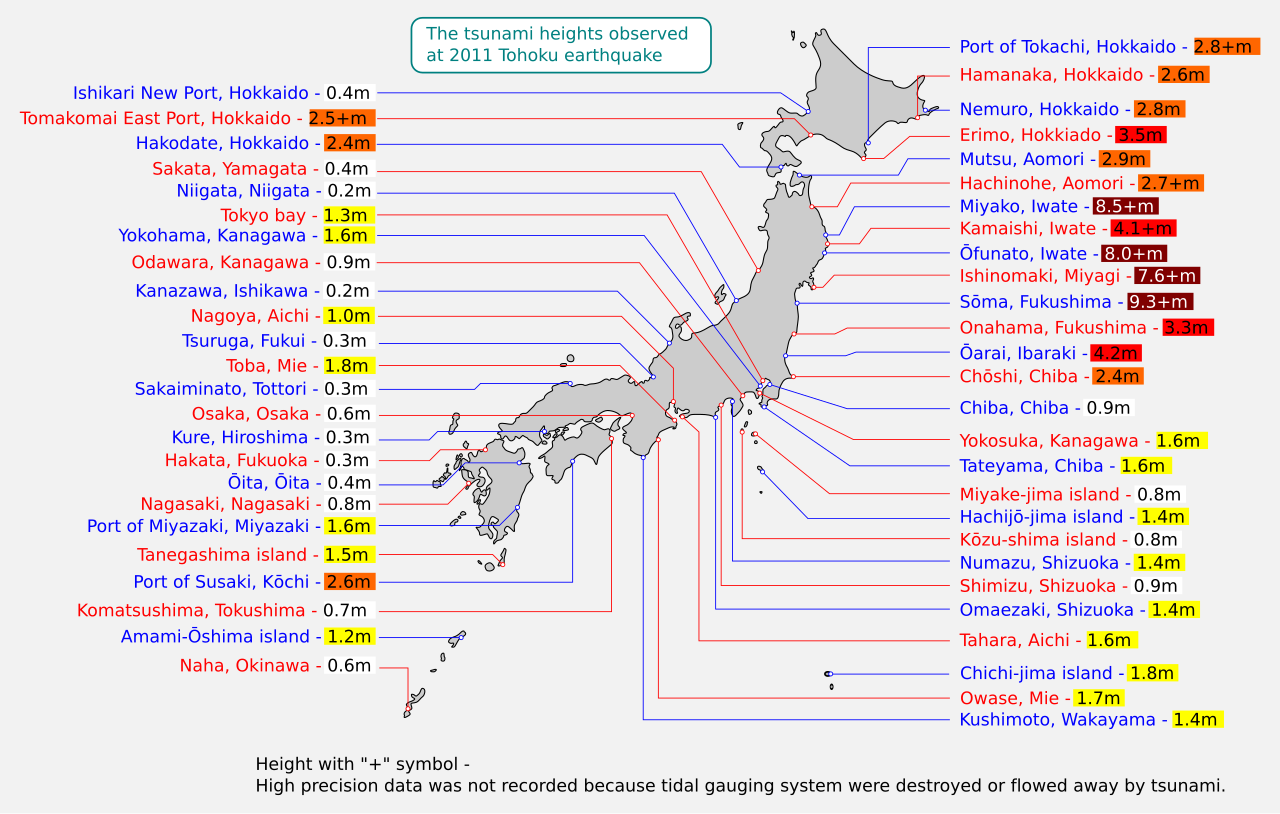
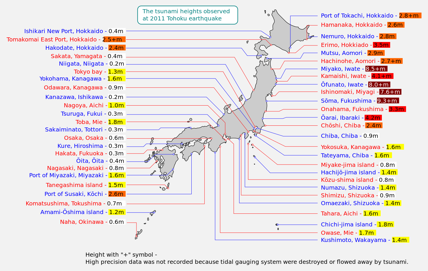
Map of 2011 Tohoku(Sendai) earthquake observed tsunami heights in Japan.
345:, without any conditions, unless such conditions are required by law.
241:
into your language, using any capable SVG editor, text editor or the
226:
507:
Click on a date/time to view the file as it appeared at that time.
328:
I, the copyright holder of this work, release this work into the
256:
416:
copyrighted, dedicated to the public domain by copyright holder
317:
93:
278:
223:
File:2011 Tohoku earthquake observed tsunami heights en.png
87:(SVG file, nominally 1,483 × 942 pixels, file size: 121 KB)
337:
In some countries this may not be legally possible; if so:
452:
released into the public domain by the copyright holder
366:
Add a one-line explanation of what this file represents
137:
117:
Commons is a freely licensed media file repository.
98:
8:
46:Size of this PNG preview of this SVG file:
612:
509:
362:
341:I grant anyone the right to use this work
297:
587:The following other wikis use this file:
622:
614:
569:
485:
469:
449:
433:
413:
397:
380:
377:
358:
351:
322:
7:
239:embedded text that can be translated
498:
221:This file is vectorised version of
605:
572:2011 Tōhoku earthquake and tsunami
371:
365:
283:
261:
155:
147:
130:
80:
595:2011 තෝහොකු භූමිකම්පාව හා සුනාමිය
370:
161:東北地方太平洋沖地震で観測された、日本各地の津波の高さ(英語版)。
356:
321:
277:
255:
230:
156:
97:
31:
21:
353:
148:
14:
352:
26:
1:
36:
378:Items portrayed in this file
245:. For more information see:
229:
577:Onagawa Nuclear Power Plant
247:About translating SVG files
644:
591:Usage on si.wikipedia.org
236:
143:Tsunami map Tohoku2011.svg
499:
334:. This applies worldwide.
284:W3C-validity not checked.
16:
355:
104:This is a file from the
556:
237:This SVG file contains
207:
199:
176:
169:
166:
140:
108:. Information from its
215:Additional information
111:description page there
70:2,560 × 1,626 pixels
535:11:44, 25 June 2013
52:Other resolutions:
243:SVG Translate tool
74:1,483 × 942 pixels
66:1,280 × 813 pixels
62:1,024 × 650 pixels
631:
630:
583:Global file usage
560:
436:copyright license
364:
350:
349:
338:
316:
315:
290:
289:
269:was created with
253:
252:
126:
125:
106:Wikimedia Commons
32:Global file usage
635:
613:
547:
400:copyright status
336:
325:
324:
318:
312:
309:
306:
303:
298:
281:
259:
234:
227:
172:
160:
152:
144:
138:
122:
101:
100:
94:
88:
77:
58:640 × 407 pixels
54:320 × 203 pixels
48:800 × 508 pixels
643:
642:
638:
637:
636:
634:
633:
632:
601:
581:
568:
561:
553:
545:
501:
500:
497:
496:
495:
494:
493:
492:
491:
490:
488:
478:
477:
476:
474:
463:
462:
461:
460:
459:
458:
457:
456:
454:
442:
441:
440:
438:
427:
426:
425:
424:
423:
422:
421:
420:
418:
406:
405:
404:
402:
391:
390:
389:
388:
387:
385:
369:
368:
367:
343:for any purpose
310:
307:
304:
301:
296:
291:
286:
285:
275:
274:
264:W3C-unspecified
218:
162:
154:
142:
135:
128:
127:
116:
115:
114:is shown below.
90:
86:
79:
78:
51:
12:
11:
5:
641:
639:
629:
628:
625:
621:
620:
617:
604:
600:
599:
598:
597:
585:
584:
580:
579:
574:
566:
565:
564:
559:
558:
555:
551:
548:
542:
537:
532:
528:
527:
524:
521:
518:
515:
512:
505:
504:
489:
486:
484:
483:
482:
481:
480:
479:
475:
470:
468:
467:
466:
465:
464:
455:
450:
448:
447:
446:
445:
444:
443:
439:
434:
432:
431:
430:
429:
428:
419:
414:
412:
411:
410:
409:
408:
407:
403:
398:
396:
395:
394:
393:
392:
386:
381:
379:
376:
375:
374:
373:
372:
361:
360:
357:
354:
348:
347:
326:
314:
313:
295:
292:
288:
287:
276:
254:
251:
250:
235:
219:
216:
212:
211:
209:
208:Other versions
205:
204:
201:
197:
196:
178:
174:
173:
168:
164:
163:
145:
136:
134:
131:
129:
124:
123:
102:
92:
91:
45:
41:
40:
39:
34:
29:
24:
19:
13:
10:
9:
6:
4:
3:
2:
640:
626:
623:
618:
615:
611:
608:
602:
596:
593:
592:
590:
589:
588:
582:
578:
575:
573:
570:
562:
554:
549:
543:
541:
538:
536:
533:
530:
529:
525:
522:
519:
516:
513:
511:
510:
508:
502:
473:
453:
437:
417:
401:
384:
346:
344:
339:
335:
333:
332:
331:public domain
327:
320:
319:
305:Public domain
302:Public domain
300:
299:
293:
280:
272:
268:
265:
258:
248:
244:
240:
233:
228:
224:
220:
214:
213:
210:
206:
202:
198:
195:
191:
187:
183:
179:
175:
165:
159:
151:
146:
139:
132:
120:
113:
112:
107:
103:
96:
95:
89:
84:
83:Original file
75:
71:
67:
63:
59:
55:
49:
44:
38:
35:
33:
30:
28:
25:
23:
20:
18:
15:
609:
606:
586:
544:1,483 × 942
506:
503:File history
487:24 June 2013
342:
340:
329:
267:vector image
263:
238:
171:24 June 2013
157:
149:
119:You can help
109:
81:
22:File history
141:Description
563:File usage
552:Eastwind41
520:Dimensions
203:Eastwind41
27:File usage
627:942.45416
619:1483.1228
517:Thumbnail
514:Date/Time
472:inception
294:Licensing
217:InfoField
150:English:
603:Metadata
546:(121 KB)
359:Captions
271:Inkscape
37:Metadata
531:current
526:Comment
383:depicts
363:English
133:Summary
85:
624:Height
282:
260:
200:Author
177:Source
616:Width
311:false
308:false
262:This
523:User
167:Date
158:日本語:
17:File
180:JMA
249:.
225:.
192:,
188:,
184:,
72:|
68:|
64:|
60:|
56:|
50:.
273:.
194:4
190:3
186:2
182:1
121:.
76:.
Text is available under the Creative Commons Attribution-ShareAlike License. Additional terms may apply.

