265:
226:
43:
240:
271:
276:
99:
818:
317:– You must give appropriate credit, provide a link to the license, and indicate if changes were made. You may do so in any reasonable manner, but not in any way that suggests the licensor endorses you or your use.
835:{{Information |Description={{en|1=Tung-yin Tao (Dongyin Dao) lighthouse, Dongyin Township, Lienchiang County, Fujian Province, Republic of China (Taiwan).}}{{zh-tw|1=中華民國(臺灣)福建省連江縣東引鄉東引島燈塔。}} |Source={{Own}} |
217:
1062:
65:
61:
57:
53:
47:
110:
695:
659:
623:
587:
468:
233:
78:
1217:
1090:
This file contains additional information, probably added from the digital camera or scanner used to create or digitize it.
324:
864:
749:
679:
643:
571:
543:
528:
515:
153:
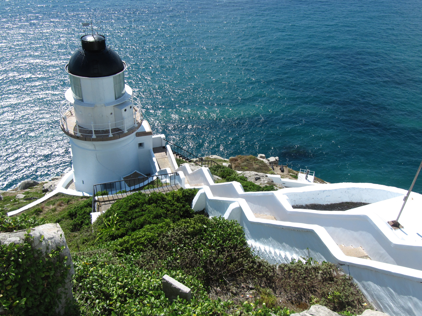
Tung-yin Tao (Dongyin Dao) lighthouse, Dongyin
Township, Lienchiang County, Fujian Province, Republic of China (Taiwan).
715:
607:
488:
452:
1042:
1112:
286:
1093:
If the file has been modified from its original state, some details may not fully reflect the modified file.
1022:
535:
845:
The following pages on the
English Knowledge (XXG) use this file (pages on other projects are not listed):
1262:
323:– If you remix, transform, or build upon the material, you must distribute your contributions under the
283:
1290:
854:
118:
1007:
817:
812:
69:
42:
1102:
1057:
550:
972:
952:
892:
239:
1358:
1280:
1244:
1119:
859:
105:
258:
I, the copyright holder of this work, hereby publish it under the following license:
1368:
1159:
897:
223:
363:
170:
Tiong-huâ Bîn-kok (Tâi-uân) Hok-kiàn-síng Liân-kang-kuān Tang-ín-hiong ting-thah.
1300:
942:
180:
1139:
828:
962:
1129:
1052:
849:
200:
1043:
Wikidata:WikiProject
Lighthouses/lists/lighthouses by country/Taiwan
882:
785:
Click on a date/time to view the file as it appeared at that time.
742:
218:
26° 21′ 57.55″ N, 120° 30′ 37.02″ E
1077:
1072:
902:
225:
351:
208:
93:
987:
1012:
997:
436:
Add a one-line explanation of what this file represents
1037:
917:
1032:
977:
937:
927:
624:
Creative
Commons Attribution-ShareAlike 3.0 Unported
137:
117:
Commons is a freely licensed media file repository.
912:
83:(1,600 × 1,200 pixels, file size: 3 MB, MIME type:
1295:Flash did not fire, compulsory flash suppression
1008:Knowledge (XXG):Veckans tävling/Asien-vecka 2020
334:https://creativecommons.org/licenses/by-sa/3.0
98:
340:Creative Commons Attribution-Share Alike 3.0
264:
8:
973:Utente:BohemianRhapsody/Distretti di Taiwan
300:– to copy, distribute and transmit the work
1095:
787:
432:
164:
163:
875:The following other wikis use this file:
156:
1393:
1385:
1377:
1366:
1356:
1348:
1340:
1332:
1324:
1316:
1308:
1298:
1288:
1278:
1270:
1260:
1252:
1242:
1234:
1226:
1215:
1207:
1199:
1191:
1183:
1175:
1167:
1156:
1148:
1137:
1127:
1117:
1107:
847:
763:
747:
729:
713:
693:
677:
657:
641:
621:
605:
585:
569:
551:https://commons.wikimedia.org/user:Dodd
502:
486:
466:
450:
447:
428:
421:
211:
898:Benutzer:Shi Annan/Dongyin, Lienchiang
232:View this and other nearby images on:
1097:
893:Benutzer:Markus Bärlocher/Leuchtfeuer
155:
7:
287:Attribution-Share Alike 3.0 Unported
776:
275:
270:
1088:
441:
435:
261:
257:
147:
130:
76:
440:
1150:Date and time of data generation
1023:Danh sách đảo Trung Hoa Dân Quốc
750:coordinates of the point of view
426:
311:Under the following conditions:
282:This file is licensed under the
274:
269:
263:
238:
224:
97:
31:
21:
765:26°21'57.550"N, 120°30'37.019"E
423:
364:View the annotations at Commons
148:
14:
963:Daftar tempat wisata di Taiwan
422:
165:
26:
1:
1172:113.57 meters above sea level
943:National Scenic Area (Taïwan)
696:original creation by uploader
36:
865:User:Aeroid/List Lighthouses
448:Items portrayed in this file
1326:Focal plane resolution unit
1228:Date and time of digitizing
1069:Usage on zh.wikivoyage.org
984:Usage on lld.wikipedia.org
909:Usage on en.wikivoyage.org
1415:
1337:One-chip color area sensor
1049:Usage on zh.wikipedia.org
1029:Usage on www.wikidata.org
1019:Usage on vi.wikipedia.org
1004:Usage on sv.wikipedia.org
994:Usage on pl.wikipedia.org
969:Usage on it.wikipedia.org
959:Usage on id.wikipedia.org
949:Usage on he.wikipedia.org
934:Usage on fr.wikipedia.org
924:Usage on es.wikipedia.org
889:Usage on de.wikipedia.org
879:Usage on cs.wikipedia.org
325:same or compatible license
143:Tungyin Tao Lighthouse.jpg
1201:File change date and time
777:
361:This image is annotated:
190:
16:
1318:Focal plane Y resolution
1310:Focal plane X resolution
1113:Canon PowerShot SX200 IS
660:Canon PowerShot SX200 IS
425:
291:
104:This is a file from the
1387:North or south latitude
1342:Custom image processing
834:
813:02:41, 4 September 2010
196:
186:
179:
176:
161:中華民國(臺灣)福建省連江縣東引鄉東引島燈塔。
140:
108:. Information from its
1395:East or west longitude
1236:Image compression mode
244:26.365986; 120.510283
111:description page there
46:Size of this preview:
1272:Maximum land aperture
1231:09:24, 27 August 2010
1204:09:24, 27 August 2010
1185:Horizontal resolution
1153:09:24, 27 August 2010
1124:1/640 sec (0.0015625)
1275:3.53125 APEX (f/3.4)
70:1,600 × 1,200 pixels
1209:Y and C positioning
1193:Vertical resolution
1099:Camera manufacturer
903:Leuchtturm Dongyong
855:Dongyong Lighthouse
469:Dongyong Lighthouse
306:– to adapt the work
52:Other resolutions:
1379:Scene capture type
1363:Auto white balance
883:Ma-cu (souostroví)
529:Wikimedia username
516:author name string
66:1,280 × 960 pixels
62:1,024 × 768 pixels
1402:
1401:
871:Global file usage
838:
608:copyright license
434:
370:
369:
249:
248:
206:
205:
167:閩南語 / Bân-lâm-gú:
126:
125:
106:Wikimedia Commons
32:Global file usage
1406:
1321:13,377.049180328
1313:13,377.049180328
1096:
825:
572:copyright status
553:
548:
538:
533:
523:
520:
352:
347:
344:
341:
338:
335:
327:as the original.
284:Creative Commons
278:
277:
273:
272:
267:
266:
245:
242:
228:
227:
221:
220:
209:
192:
182:
169:
160:
152:
144:
138:
122:
101:
100:
94:
88:
86:
73:
58:640 × 480 pixels
54:320 × 240 pixels
48:800 × 600 pixels
1414:
1413:
1409:
1408:
1407:
1405:
1404:
1403:
1084:
988:Dongyin (Matsu)
869:
846:
839:
831:
823:
779:
778:
775:
774:
773:
772:
771:
770:
769:
768:
766:
756:
755:
754:
752:
741:
740:
739:
738:
737:
736:
735:
734:
732:
722:
721:
720:
718:
707:
706:
705:
704:
703:
702:
701:
700:
698:
686:
685:
684:
682:
671:
670:
669:
668:
667:
666:
665:
664:
662:
650:
649:
648:
646:
635:
634:
633:
632:
631:
630:
629:
628:
626:
614:
613:
612:
610:
599:
598:
597:
596:
595:
594:
593:
592:
590:
578:
577:
576:
574:
563:
562:
561:
560:
559:
558:
557:
556:
555:
554:
549:
546:
540:
539:
534:
531:
525:
524:
521:
518:
509:
508:
507:
505:
495:
494:
493:
491:
480:
479:
478:
477:
476:
475:
474:
473:
471:
459:
458:
457:
455:
439:
438:
437:
420:
419:
414:
411:
408:
405:
402:
399:
395:
394:
389:
386:
383:
380:
377:
374:
358:
350:
349:
348:
345:
342:
339:
336:
333:
332:
290:
279:
260:
259:
254:
243:
216:
215:
212:Camera location
207:
172:
171:
162:
154:
142:
135:
128:
127:
116:
115:
114:is shown below.
90:
84:
82:
75:
74:
51:
12:
11:
5:
1412:
1410:
1400:
1399:
1398:East longitude
1396:
1392:
1391:
1390:North latitude
1388:
1384:
1383:
1380:
1376:
1375:
1372:
1365:
1364:
1361:
1355:
1354:
1351:
1347:
1346:
1345:Normal process
1343:
1339:
1338:
1335:
1334:Sensing method
1331:
1330:
1327:
1323:
1322:
1319:
1315:
1314:
1311:
1307:
1306:
1303:
1297:
1296:
1293:
1287:
1286:
1283:
1277:
1276:
1273:
1269:
1268:
1265:
1259:
1258:
1255:
1251:
1250:
1247:
1241:
1240:
1237:
1233:
1232:
1229:
1225:
1224:
1221:
1214:
1213:
1210:
1206:
1205:
1202:
1198:
1197:
1194:
1190:
1189:
1186:
1182:
1181:
1178:
1174:
1173:
1170:
1166:
1165:
1162:
1155:
1154:
1151:
1147:
1146:
1143:
1136:
1135:
1132:
1126:
1125:
1122:
1116:
1115:
1110:
1106:
1105:
1100:
1087:
1083:
1082:
1081:
1080:
1075:
1067:
1066:
1065:
1063:中華民國福建省二級行政區列表
1060:
1055:
1047:
1046:
1045:
1040:
1035:
1027:
1026:
1025:
1017:
1016:
1015:
1010:
1002:
1001:
1000:
992:
991:
990:
982:
981:
980:
975:
967:
966:
965:
957:
956:
955:
947:
946:
945:
940:
932:
931:
930:
922:
921:
920:
915:
907:
906:
905:
900:
895:
887:
886:
885:
873:
872:
868:
867:
862:
857:
852:
844:
843:
842:
837:
836:
833:
829:
826:
822:1,600 × 1,200
820:
815:
810:
806:
805:
802:
799:
796:
793:
790:
783:
782:
767:
764:
762:
761:
760:
759:
758:
757:
753:
748:
746:
745:
744:
743:
733:
731:27 August 2010
730:
728:
727:
726:
725:
724:
723:
719:
714:
712:
711:
710:
709:
708:
699:
694:
692:
691:
690:
689:
688:
687:
683:
680:source of file
678:
676:
675:
674:
673:
672:
663:
658:
656:
655:
654:
653:
652:
651:
647:
642:
640:
639:
638:
637:
636:
627:
622:
620:
619:
618:
617:
616:
615:
611:
606:
604:
603:
602:
601:
600:
591:
586:
584:
583:
582:
581:
580:
579:
575:
570:
568:
567:
566:
565:
564:
542:
541:
527:
526:
514:
513:
512:
511:
510:
506:
503:
501:
500:
499:
498:
497:
496:
492:
487:
485:
484:
483:
482:
481:
472:
467:
465:
464:
463:
462:
461:
460:
456:
451:
449:
446:
445:
444:
443:
442:
431:
430:
427:
424:
415:
412:
409:
406:
403:
400:
397:
396:
390:
387:
384:
381:
378:
375:
372:
371:
368:
367:
359:
356:
331:
330:
329:
328:
318:
309:
308:
307:
301:
294:You are free:
281:
280:
262:
256:
255:
253:
250:
247:
246:
236:
230:
213:
204:
203:
198:
194:
193:
188:
184:
183:
181:27 August 2010
178:
174:
173:
145:
136:
134:
131:
129:
124:
123:
102:
92:
91:
45:
41:
40:
39:
34:
29:
24:
19:
13:
10:
9:
6:
4:
3:
2:
1411:
1397:
1394:
1389:
1386:
1381:
1378:
1373:
1370:
1367:
1362:
1360:
1359:White balance
1357:
1353:Auto exposure
1352:
1350:Exposure mode
1349:
1344:
1341:
1336:
1333:
1328:
1325:
1320:
1317:
1312:
1309:
1304:
1302:
1299:
1294:
1292:
1289:
1284:
1282:
1281:Metering mode
1279:
1274:
1271:
1266:
1264:
1263:Exposure bias
1261:
1256:
1254:APEX aperture
1253:
1248:
1246:
1245:Shutter speed
1243:
1238:
1235:
1230:
1227:
1222:
1219:
1216:
1211:
1208:
1203:
1200:
1195:
1192:
1187:
1184:
1179:
1176:
1171:
1168:
1163:
1161:
1157:
1152:
1149:
1144:
1141:
1138:
1133:
1131:
1128:
1123:
1121:
1120:Exposure time
1118:
1114:
1111:
1108:
1104:
1101:
1098:
1094:
1091:
1085:
1079:
1076:
1074:
1071:
1070:
1068:
1064:
1061:
1059:
1056:
1054:
1051:
1050:
1048:
1044:
1041:
1039:
1036:
1034:
1031:
1030:
1028:
1024:
1021:
1020:
1018:
1014:
1011:
1009:
1006:
1005:
1003:
999:
996:
995:
993:
989:
986:
985:
983:
979:
976:
974:
971:
970:
968:
964:
961:
960:
958:
954:
951:
950:
948:
944:
941:
939:
936:
935:
933:
929:
926:
925:
923:
919:
916:
914:
911:
910:
908:
904:
901:
899:
896:
894:
891:
890:
888:
884:
881:
880:
878:
877:
876:
870:
866:
863:
861:
860:Matsu Islands
858:
856:
853:
851:
848:
840:
832:
827:
821:
819:
816:
814:
811:
808:
807:
803:
800:
797:
794:
791:
789:
788:
786:
780:
751:
717:
697:
681:
661:
645:
644:captured with
625:
609:
589:
573:
552:
545:
537:
530:
517:
490:
470:
454:
418:
393:
366:
365:
360:
354:
353:
337:CC BY-SA 3.0
326:
322:
319:
316:
313:
312:
310:
305:
302:
299:
296:
295:
293:
292:
288:
285:
268:
251:
241:
237:
235:
234:OpenStreetMap
231:
229:
219:
214:
210:
202:
199:
195:
189:
185:
175:
168:
159:
151:
146:
139:
132:
120:
113:
112:
107:
103:
96:
95:
89:
80:
79:Original file
71:
67:
63:
59:
55:
49:
44:
38:
35:
33:
30:
28:
25:
23:
20:
18:
15:
1369:Digital zoom
1160:focal length
1109:Camera model
1092:
1089:
1013:Dongyong fyr
874:
784:
781:File history
522:Ying-lung LU
416:
391:
362:
320:
314:
303:
297:
201:Ying-lung LU
166:
157:
149:
119:You can help
109:
77:
22:File history
1301:Color space
1177:Orientation
998:Mazu Liedao
588:copyrighted
355:Annotations
321:share alike
315:attribution
141:Description
841:File usage
798:Dimensions
504:some value
417:閩海關 東涌鐙塔碑
85:image/jpeg
27:File usage
1382:Landscape
1140:ISO speed
1038:Q11103346
795:Thumbnail
792:Date/Time
716:inception
357:InfoField
252:Licensing
150:English:
1212:Co-sited
1169:Altitude
1164:5.581 mm
1130:F-number
1086:Metadata
953:איי מטסו
429:Captions
304:to remix
298:to share
289:license.
191:Own work
37:Metadata
1285:Pattern
1220:version
1196:300 dpi
1188:300 dpi
1033:Q262171
978:Dongyin
938:Dongyin
928:Dongyin
918:Dongyin
850:Dongyin
809:current
804:Comment
489:creator
453:depicts
433:English
158:中文(臺灣):
133:Summary
81:
1329:inches
1249:9.3125
1180:Normal
1142:rating
824:(3 MB)
392:霧砲與霧笛
222:
197:Author
187:Source
1371:ratio
1291:Flash
1158:Lens
1103:Canon
1058:東引島燈塔
913:Matsu
1305:sRGB
1223:2.21
1218:Exif
830:Dodd
801:User
536:Dodd
413:1200
410:1600
401:1020
388:1200
385:1600
373:1004
346:true
343:true
177:Date
17:File
1134:f/4
1053:東引鄉
544:URL
407:154
404:160
398:590
382:100
379:222
376:600
1145:80
1078:東引
1073:馬祖
547::
532::
519::
68:|
64:|
60:|
56:|
50:.
1374:1
1267:0
1257:4
1239:3
121:.
87:)
72:.
Text is available under the Creative Commons Attribution-ShareAlike License. Additional terms may apply.