354:
43:
276:
95:
149:
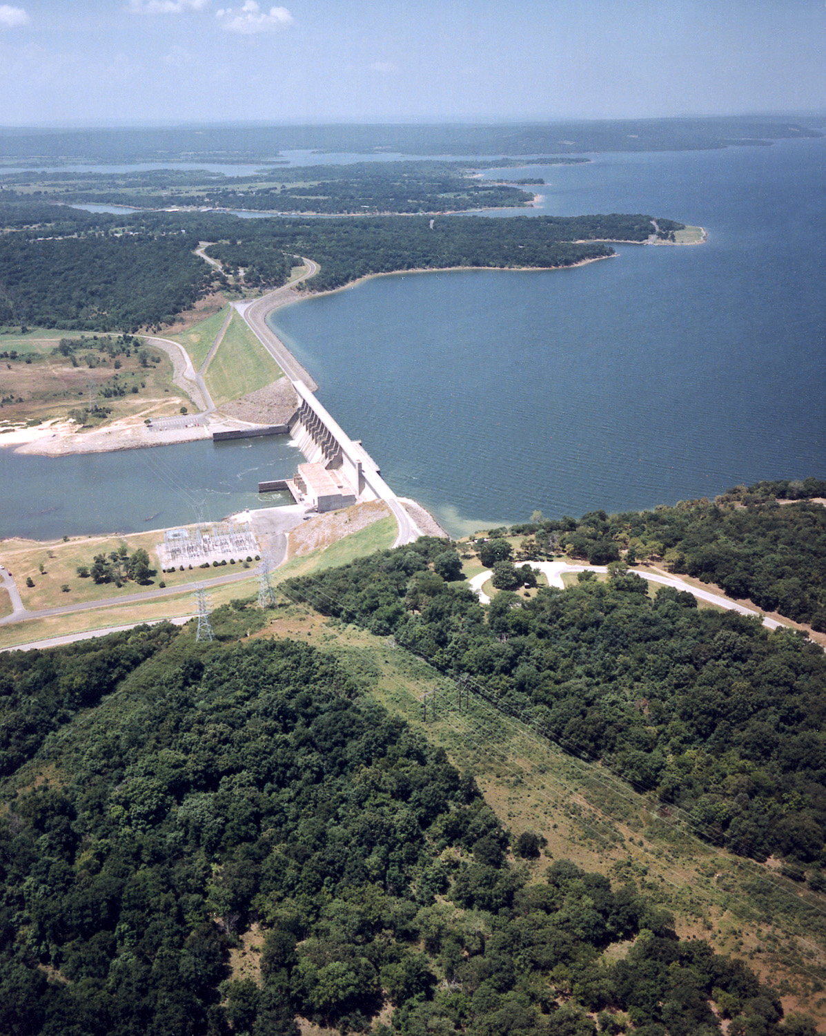
Aerial view of Lake
Eufaula and Dam on the Canadian River in the U.S. state of Oklahoma. The lake is located in McIntosh, Pittsburg, and Haskell Counties. The lake is located approximately 65 miles (104 km) south-southeast of the city of Tulsa. The U.S. Army Corps of Engineers constructed the dam for
557:
574:{{Information | Description = {{en|Aerial view of Lake Eufaula and Dam on the Canadian River in the U.S. state of Oklahoma. The lake is located in McIntosh, Pittsburg, and Haskell Counties. The lake is located approximately 65 miles (104 km) south-sout
220:
154:
61:
57:
53:
47:
106:
74:
603:
292:
288:
243:
467:
724:
This file contains additional information, probably added from the digital camera or scanner used to create or digitize it.
432:
344:
696:
445:
416:
488:
460:
399:
631:
452:
598:
727:
If the file has been modified from its original state, some details may not fully reflect the modified file.
593:
584:
The following pages on the
English Knowledge (XXG) use this file (pages on other projects are not listed):
556:
551:
284:
206:
Dates provided by U.S. Army Corps of
Engineers Digital Visual Library are not reliable and may be wrong.)
65:
42:
656:
651:
114:
621:
327:
339:
335:
331:
323:
319:
315:
311:
307:
216:
297:
101:
287:
soldier or employee, taken or made as part of that person's official duties. As a
588:
199:
567:
169:
156:
661:
632:
Eufaula Dam (alihan sa tubig sa
Tinipong Bansa, lat 35,31, long -95,36)
524:
Click on a date/time to view the file as it appeared at that time.
234:
U.S. Army Corps of
Engineers, photographer not specified or unknown
224:
686:
270:
89:
352:
681:
657:
Anexo:Embalses del mundo por superficie y volumen de agua
641:
671:
652:
Anexo:Lagos y embalses de
Estados Unidos por superficie
383:
Add a one-line explanation of what this file represents
711:
79:(1,197 × 1,500 pixels, file size: 769 KB, MIME type:
706:
133:
113:
Commons is a freely licensed media file repository.
468:
work of the federal government of the United States
214:
U.S. Army Corps of
Engineers Digital Visual Library
94:
604:Knowledge (XXG):WikiProject Lakes/Galleries/3
8:
191:Mcintosh and Haskell Counties, Oklahoma, USA
729:
526:
379:
343:
250:
614:The following other wikis use this file:
731:
586:
502:
486:
430:
414:
397:
394:
375:
368:
139:USACE Eufaula Lake and Dam Oklahoma.jpg
275:
7:
736:File written by Adobe Photoshop¨ 5.0
515:
722:
388:
382:
283:This image or file is a work of a
281:
143:
126:
72:
387:
373:
274:
225:Digital Visual Library home page
93:
31:
21:
370:
150:flood control and water supply.
144:
14:
369:
26:
1:
662:Condado de Haskell (Oklahoma)
36:
395:Items portrayed in this file
285:U.S. Army Corps of Engineers
628:Usage on ceb.wikipedia.org
618:Usage on arz.wikipedia.org
753:
703:Usage on www.wikidata.org
693:Usage on sr.wikipedia.org
678:Usage on it.wikipedia.org
668:Usage on fr.wikipedia.org
648:Usage on es.wikipedia.org
638:Usage on de.wikipedia.org
599:Oklahoma State Highway 71
516:
170:35.3065806°N 95.3584222°W
16:
453:United States of America
372:
100:This is a file from the
594:Lake Eufaula (Oklahoma)
573:
446:applies to jurisdiction
293:U.S. federal government
238:
230:
210:
198:
195:
175:35.3065806; -95.3584222
136:
104:. Information from its
357:
295:, the image is in the
221:Image description page
107:description page there
46:Size of this preview:
356:
461:determination method
66:1,197 × 1,500 pixels
52:Other resolutions:
687:Eufaula (Oklahoma)
552:03:10, 15 May 2007
358:
740:
739:
733:JPEG file comment
610:Global file usage
577:
381:
366:
365:
362:
361:
347:
269:
268:
247:
244:Reusing this file
122:
121:
102:Wikimedia Commons
32:Global file usage
744:
730:
564:
470:
465:
455:
450:
417:copyright status
355:
348:
278:
277:
271:
265:
262:
259:
256:
251:
241:
201:
180:
178:
177:
176:
171:
167:
166:
163:
162:
159:
148:
140:
134:
118:
97:
96:
90:
84:
82:
69:
62:613 × 768 pixels
58:383 × 480 pixels
54:191 × 240 pixels
48:478 × 599 pixels
752:
751:
747:
746:
745:
743:
742:
741:
718:
697:Јуфола (језеро)
608:
585:
578:
570:
562:
518:
517:
514:
513:
512:
511:
510:
509:
508:
507:
505:
495:
494:
493:
491:
480:
479:
478:
477:
476:
475:
474:
473:
472:
471:
466:
463:
457:
456:
451:
448:
439:
438:
437:
435:
423:
422:
421:
419:
408:
407:
406:
405:
404:
402:
386:
385:
384:
367:
353:
306:
303:
263:
260:
257:
254:
188:
174:
172:
168:
164:
160:
157:
155:
153:
151:
138:
131:
124:
123:
112:
111:
110:is shown below.
86:
80:
78:
71:
70:
51:
12:
11:
5:
750:
748:
738:
737:
734:
721:
717:
716:
715:
714:
709:
701:
700:
699:
691:
690:
689:
684:
676:
675:
674:
666:
665:
664:
659:
654:
646:
645:
644:
636:
635:
634:
626:
625:
624:
612:
611:
607:
606:
601:
596:
591:
583:
582:
581:
576:
575:
572:
568:
565:
561:1,197 × 1,500
559:
554:
549:
545:
544:
541:
538:
535:
532:
529:
522:
521:
506:
503:
501:
500:
499:
498:
497:
496:
492:
487:
485:
484:
483:
482:
481:
459:
458:
444:
443:
442:
441:
440:
436:
431:
429:
428:
427:
426:
425:
424:
420:
415:
413:
412:
411:
410:
409:
403:
398:
396:
393:
392:
391:
390:
389:
378:
377:
374:
371:
364:
363:
360:
359:
350:
279:
267:
266:
248:
236:
235:
232:
228:
227:
212:
208:
207:
197:
193:
192:
189:
186:
182:
181:
141:
132:
130:
127:
125:
120:
119:
98:
88:
87:
45:
41:
40:
39:
34:
29:
24:
19:
13:
10:
9:
6:
4:
3:
2:
749:
735:
732:
728:
725:
719:
713:
710:
708:
705:
704:
702:
698:
695:
694:
692:
688:
685:
683:
680:
679:
677:
673:
670:
669:
667:
663:
660:
658:
655:
653:
650:
649:
647:
643:
640:
639:
637:
633:
630:
629:
627:
623:
620:
619:
617:
616:
615:
609:
605:
602:
600:
597:
595:
592:
590:
587:
579:
571:
566:
560:
558:
555:
553:
550:
547:
546:
542:
539:
536:
533:
530:
528:
527:
525:
519:
490:
469:
462:
454:
447:
434:
433:public domain
418:
401:
351:
349:
346:
341:
337:
333:
329:
325:
321:
317:
313:
309:
304:
302:
300:
299:
298:public domain
294:
290:
286:
280:
273:
272:
258:Public domain
255:Public domain
253:
252:
249:
245:
240:
237:
233:
229:
226:
223:
222:
219:
218:
215:
213:
209:
205:
194:
190:
184:
183:
179:
161:95°21′30.32″W
158:35°18′23.69″N
152:Coordinates:
147:
142:
135:
128:
116:
109:
108:
103:
99:
92:
91:
85:
76:
75:Original file
67:
63:
59:
55:
49:
44:
38:
35:
33:
30:
28:
25:
23:
20:
18:
15:
726:
723:
682:Lago Eufaula
642:Eufaula Lake
613:
523:
520:File history
504:3 March 1999
305:
296:
282:
203:
200:3 March 1999
145:
115:You can help
105:
73:
22:File history
672:Lac Eufaula
589:Eufaula Dam
332:slovenščina
137:Description
580:File usage
537:Dimensions
340:українська
316:Nederlands
239:Permission
217:Image page
81:image/jpeg
27:File usage
622:سد يوفولا
534:Thumbnail
531:Date/Time
489:inception
328:sicilianu
187:InfoField
146:English:
720:Metadata
712:Q5406817
563:(769 KB)
376:Captions
342: |
338: |
334: |
330: |
326: |
322: |
318: |
314: |
312:italiano
310: |
185:Location
37:Metadata
707:Q539259
548:current
543:Comment
400:depicts
380:English
324:русский
308:English
291:of the
204:Caveat:
129:Summary
77:
336:Türkçe
231:Author
211:Source
569:DanMS
264:false
261:false
540:User
320:پښتو
289:work
196:Date
17:File
345:+/−
165:/
464::
449::
173:/
64:|
60:|
56:|
50:.
301:.
246:)
242:(
202:(
117:.
83:)
68:.
Text is available under the Creative Commons Attribution-ShareAlike License. Additional terms may apply.