311:
43:
343:
357:
233:
95:
590:
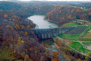
607:{{Information | Description = {{en|Loyalhanna Lake and Dam on the Loyalhanna Creek in Westmoreland County near Saltsburg, Pennsylvania, USA. The U.S. Army Corps of Engineers constructed the dam for flood control on Loyalhanna Creek. View is upriver to
334:
177:
249:
61:
57:
53:
47:
106:
245:
74:
200:
466:
350:
677:
This file contains additional information, probably added from the digital camera or scanner used to create or digitize it.
431:
301:
521:
444:
415:
487:
459:
398:
451:
680:
If the file has been modified from its original state, some details may not fully reflect the modified file.
144:
Loyalhanna Lake and Dam on the
Loyalhanna Creek in Westmoreland County near Saltsburg, Pennsylvania, USA.
241:
589:
584:
65:
42:
114:
621:
284:
150:
The U.S. Army Corps of
Engineers constructed the dam for flood control on Loyalhanna Creek.
626:
296:
292:
288:
280:
276:
272:
268:
264:
173:
356:
254:
101:
340:
244:
soldier or employee, taken or made as part of that person's official duties. As a
161:
600:
557:
Click on a date/time to view the file as it appeared at that time.
514:
342:
335:
40° 27′ 24.16″ N, 79° 27′ 04.61″ W
181:
644:
325:
227:
89:
654:
309:
382:
Add a one-line explanation of what this file represents
664:
79:(1,500 × 1,001 pixels, file size: 570 KB, MIME type:
128:
113:
Commons is a freely licensed media file repository.
467:
work of the federal government of the United States
171:
U.S. Army Corps of
Engineers Digital Visual Library
94:
191:Margaret Luzier, U.S. Army Corps of Engineers
8:
682:
559:
378:
300:
207:
637:The following other wikis use this file:
684:
619:
535:
519:
501:
485:
429:
413:
396:
393:
374:
367:
328:
349:View this and other nearby images on:
147:View is upriver to the west-southwest.
617:The following 2 pages use this file:
232:
7:
689:File written by Adobe Photoshop¨ 5.0
548:
675:
387:
381:
240:This image or file is a work of a
238:
138:
126:
72:
386:
134:USACE Loyalhanna Lake and Dam.jpg
522:coordinates of the point of view
372:
355:
341:
231:
182:Digital Visual Library home page
93:
31:
21:
369:
139:
14:
368:
26:
1:
537:40°27'24.160"N, 79°27'4.612"W
36:
394:Items portrayed in this file
242:U.S. Army Corps of Engineers
641:Usage on ceb.wikipedia.org
706:
661:Usage on www.wikidata.org
651:Usage on fr.wikipedia.org
549:
16:
452:United States of America
371:
100:This is a file from the
606:
445:applies to jurisdiction
250:U.S. federal government
195:
187:
167:
160:
157:
131:
104:. Information from its
361:40.456711; -79.451281
314:
252:, the image is in the
178:Image description page
107:description page there
46:Size of this preview:
313:
585:01:33, 28 March 2007
460:determination method
66:1,500 × 1,001 pixels
52:Other resolutions:
315:
62:1,024 × 683 pixels
693:
692:
686:JPEG file comment
633:Global file usage
610:
380:
366:
365:
323:
322:
319:
318:
304:
226:
225:
204:
201:Reusing this file
122:
121:
102:Wikimedia Commons
32:Global file usage
697:
683:
655:Loyalhanna Creek
645:Loyalhanna Creek
622:Loyalhanna Creek
597:
469:
464:
454:
449:
416:copyright status
362:
359:
345:
344:
338:
337:
326:
312:
305:
235:
234:
228:
222:
219:
216:
213:
208:
198:
163:
143:
135:
129:
118:
97:
96:
90:
84:
82:
69:
58:640 × 427 pixels
54:320 × 214 pixels
48:800 × 534 pixels
705:
704:
700:
699:
698:
696:
695:
694:
671:
631:
627:Loyalhanna Lake
611:
603:
595:
551:
550:
547:
546:
545:
544:
543:
542:
541:
540:
538:
528:
527:
526:
524:
513:
512:
511:
510:
509:
508:
507:
506:
504:
503:15 October 1993
494:
493:
492:
490:
479:
478:
477:
476:
475:
474:
473:
472:
471:
470:
465:
462:
456:
455:
450:
447:
438:
437:
436:
434:
422:
421:
420:
418:
407:
406:
405:
404:
403:
401:
385:
384:
383:
360:
333:
332:
329:Camera location
324:
310:
263:
260:
220:
217:
214:
211:
162:15 October 1993
153:
133:
124:
123:
112:
111:
110:is shown below.
86:
80:
78:
71:
70:
51:
12:
11:
5:
703:
701:
691:
690:
687:
674:
670:
669:
668:
667:
659:
658:
657:
649:
648:
647:
635:
634:
630:
629:
624:
615:
614:
609:
608:
605:
601:
598:
594:1,500 × 1,001
592:
587:
582:
578:
577:
574:
571:
568:
565:
562:
555:
554:
539:
536:
534:
533:
532:
531:
530:
529:
525:
520:
518:
517:
516:
515:
505:
502:
500:
499:
498:
497:
496:
495:
491:
486:
484:
483:
482:
481:
480:
458:
457:
443:
442:
441:
440:
439:
435:
430:
428:
427:
426:
425:
424:
423:
419:
414:
412:
411:
410:
409:
408:
402:
397:
395:
392:
391:
390:
389:
388:
377:
376:
373:
370:
364:
363:
353:
347:
330:
321:
320:
317:
316:
307:
236:
224:
223:
205:
193:
192:
189:
185:
184:
169:
165:
164:
159:
155:
154:
152:
151:
148:
136:
127:
125:
120:
119:
98:
88:
87:
45:
41:
40:
39:
34:
29:
24:
19:
13:
10:
9:
6:
4:
3:
2:
702:
688:
685:
681:
678:
672:
666:
663:
662:
660:
656:
653:
652:
650:
646:
643:
642:
640:
639:
638:
632:
628:
625:
623:
620:
618:
612:
604:
599:
593:
591:
588:
586:
583:
580:
579:
575:
572:
569:
566:
563:
561:
560:
558:
552:
523:
489:
468:
461:
453:
446:
433:
432:public domain
417:
400:
358:
354:
352:
351:OpenStreetMap
348:
346:
336:
331:
327:
308:
306:
303:
298:
294:
290:
286:
282:
278:
274:
270:
266:
261:
259:
257:
256:
255:public domain
251:
247:
243:
237:
230:
229:
215:Public domain
212:Public domain
210:
209:
206:
202:
197:
194:
190:
186:
183:
180:
179:
176:
175:
172:
170:
166:
156:
149:
146:
145:
142:
137:
130:
116:
109:
108:
103:
99:
92:
91:
85:
76:
75:Original file
67:
63:
59:
55:
49:
44:
38:
35:
33:
30:
28:
25:
23:
20:
18:
15:
679:
676:
636:
616:
556:
553:File history
262:
253:
239:
140:
115:You can help
105:
73:
22:File history
289:slovenščina
132:Description
613:File usage
570:Dimensions
297:українська
273:Nederlands
196:Permission
174:Image page
81:image/jpeg
27:File usage
567:Thumbnail
564:Date/Time
488:inception
285:sicilianu
141:English:
673:Metadata
665:Q6694452
596:(570 KB)
375:Captions
299: |
295: |
291: |
287: |
283: |
279: |
275: |
271: |
269:italiano
267: |
37:Metadata
581:current
576:Comment
399:depicts
379:English
281:русский
265:English
248:of the
77:
339:
293:Türkçe
188:Author
168:Source
602:DanMS
221:false
218:false
573:User
277:پښتو
246:work
158:Date
17:File
302:+/−
463::
448::
64:|
60:|
56:|
50:.
258:.
203:)
199:(
117:.
83:)
68:.
Text is available under the Creative Commons Attribution-ShareAlike License. Additional terms may apply.
