284:
43:
1262:
272:
1257:
260:
568:
574:
304:
99:
864:
1197:
1164:
1159:
1154:
1149:
1144:
1139:
1134:
1129:
1124:
1119:
1114:
1109:
1104:
615:– You must give appropriate credit, provide a link to the license, and indicate if changes were made. You may do so in any reasonable manner, but not in any way that suggests the licensor endorses you or your use.
899:
1099:
1267:
1481:
1232:
1094:
904:
1084:
65:
61:
57:
53:
47:
1227:
110:
78:
914:
909:
318:
1247:
1019:
1217:
1179:
1237:
1174:
1069:
885:}} Quadratische Plattkarte, N-S-Streckung 130.0 %. Geographische Begrenzung der Karte: {{en|Physical location map of [[:en:Western U
1024:
944:
775:
739:
703:
283:
1064:
954:
1492:
This file contains additional information, probably added from the digital camera or scanner used to create or digitize it.
1169:
759:
687:
1074:
795:
723:
670:
959:
999:
311:
1034:
543:
271:
1495:
If the file has been modified from its original state, some details may not fully reflect the modified file.
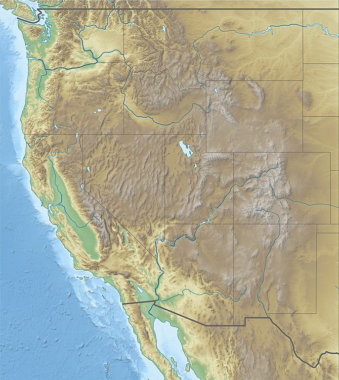
881:== {{int:filedesc}} == {{Information |Description= {{de|Physische Positionskarte der westlichen Staaten der
259:
168:
1242:
979:
929:
895:
The following pages on the
English Knowledge (XXG) use this file (pages on other projects are not listed):
863:
858:
69:
42:
919:
584:
1089:
1059:
581:
1079:
1352:
989:
118:
1049:
1009:
939:
924:
1039:
984:
1442:
1004:
934:
303:
159:
Quadratische
Plattkarte, N-S-Streckung 130.0 %. Geographische Begrenzung der Karte:
1467:
969:
177:
Equirectangular projection, N/S stretching 130.0 %. Geographic limits of the map:
1372:
1054:
1014:
974:
964:
949:
105:
561:
I, the copyright holder of this work, hereby publish it under the following license:
353:
1044:
994:
874:
232:
245:
461:
425:
1447:
1277:
533:
524:
515:
506:
497:
488:
479:
470:
452:
443:
434:
416:
407:
398:
389:
380:
371:
362:
344:
335:
326:
1457:
1367:
1029:
200:
1207:
1317:
1432:
1165:
User:Ty654/List of earthquakes from 2010-2014 exceeding magnitude 6+
1160:
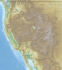
User:Ty654/List of earthquakes from 1995-1999 exceeding magnitude 6+
1155:
User:Ty654/List of earthquakes from 1990-1994 exceeding magnitude 6+
1150:
User:Ty654/List of earthquakes from 1980-1984 exceeding magnitude 6+
1145:
User:Ty654/List of earthquakes from 1975-1979 exceeding magnitude 6+
1140:
User:Ty654/List of earthquakes from 1960-1964 exceeding magnitude 6+
1135:
User:Ty654/List of earthquakes from 1955-1959 exceeding magnitude 6+
1130:
User:Ty654/List of earthquakes from 1950-1954 exceeding magnitude 6+
1125:
User:Ty654/List of earthquakes from 1940-1949 exceeding magnitude 6+
1120:
User:Ty654/List of earthquakes from 1930-1939 exceeding magnitude 6+
1115:
User:Ty654/List of earthquakes from 1920-1929 exceeding magnitude 6+
1110:
User:Ty654/List of earthquakes from 1910-1919 exceeding magnitude 6+
1105:
User:Ty654/List of earthquakes from 1900-1949 exceeding magnitude 7+
1427:
1212:
900:
1967 NCAA University
Division outdoor track and field championships
831:
Click on a date/time to view the file as it appeared at that time.
1100:
User:Ty654/List of earthquakes before 1900 exceeding magnitude 8+
172:
1462:
1437:
1412:
1417:
1362:
882:
218:
154:
1472:
1452:
1337:
1307:
93:
1263:মডিউল:অবস্থান মানচিত্র/উপাত্ত/মার্কিন যুক্তরাষ্ট্র পশ্চিম/নথি
1382:
1353:
Knowledge (XXG):Kartenwerkstatt/Positionskarten/Nordamerika
1347:
1327:
225:
1422:
1392:
1377:
1357:
1292:
1095:
User:Michael!/Project:Location map templates/United States
905:
1387:
1322:
1302:
1258:মডিউল:অবস্থান মানচিত্র/উপাত্ত/মার্কিন যুক্তরাষ্ট্র পশ্চিম
354:
1342:
1297:
654:
Add a one-line explanation of what this file represents
1407:
1312:
1287:
1332:
83:(1,867 × 2,091 pixels, file size: 1.4 MB, MIME type:
298:
153:
137:
117:
Commons is a freely licensed media file repository.
1402:
1218:Şablon:Yer xəritəsi Amerika Birləşmiş Ştatları Qərb
462:
426:
1085:Wichita State University football team plane crash
534:
525:
516:
507:
498:
489:
480:
471:
453:
444:
435:
417:
408:
399:
390:
381:
372:
363:
345:
336:
327:
310:This map has been made or improved in the German
233:http://www.ngdc.noaa.gov/mgg/global/global.html
1373:Knowledge (XXG):Kartenwerkstatt/Archiv/2010-04
98:
567:
8:
622:https://creativecommons.org/licenses/by/3.0
598:– to copy, distribute and transmit the work
1497:
1020:Mutilation of "Snippy" the horse
833:
650:
542:
1443:Ŝablono:Geokesto lokumilo Okcidenta Usono
1190:The following other wikis use this file:
915:Alpine skiing at the 2002 Winter Olympics
910:Alpine skiing at the 1960 Winter Olympics
740:Creative Commons Attribution 3.0 Unported
1499:
897:
809:
793:
773:
757:
737:
721:
701:
685:
668:
665:
646:
639:
255:
143:USA Region West relief location map.jpg
1468:Ŝablono:Situo sur mapo Okcidenta Usono
1198:قالب:خريطة مواقع غرب الولايات المتحدة
1180:Module:Location map/data/USA West/doc
7:
822:
573:
1490:
659:
653:
589:
564:
560:
309:
161:
147:
130:
76:
1175:Module:Location map/data/USA West
1070:Treasure Valley Community College
658:
628:Creative Commons Attribution 3.0
1170:Knowledge (XXG):WikiProject Dams
1025:National Interagency Fire Center
945:Central Plains Biosphere Reserve
644:
609:Under the following conditions:
580:This file is licensed under the
572:
566:
302:
282:
270:
258:
97:
31:
21:
1458:Nacia Observatorio de Kitt Peak
1368:Vorlage:Positionskarte USA West
1278:Plantilya:Location map USA West
1065:Tamarack Ski Area (Troy, Idaho)
955:Farragut Naval Training Station
641:
162:
14:
640:
148:
26:
1:
776:original creation by uploader
36:
666:Items portrayed in this file
289:Physical map with land cover
219:http://naturalearthdata.com/
1448:Port Townsend (Vaŝingtonio)
1274:Usage on ceb.wikipedia.org
1233:Ҡалып:ПозКарта АҠШ Көнбайыш
1075:United Airlines Flight 2860
1521:
1399:Usage on eo.wikipedia.org
1284:Usage on de.wikipedia.org
1254:Usage on bn.wikipedia.org
1224:Usage on ba.wikipedia.org
1204:Usage on az.wikipedia.org
1194:Usage on ar.wikipedia.org
960:Fraser Experimental Forest
1318:Tennessee Pass (Colorado)
1000:Jornada Biosphere Reserve
823:
224:SRTM3, AVHRR Land Cover (
211:
167:Physical location map of
16:
643:
585:Attribution 3.0 Unported
226:http://www.landcover.org
104:This is a file from the
880:
251:
241:
206:
199:
196:
140:
108:. Information from its
1208:Yellouston Milli Parkı
1090:Women's Challenge
980:History of Felts Field
930:Camas Prairie Railroad
111:description page there
46:Size of this preview:
920:Battle of San Pasqual
169:Western United States
1248:Олимпик (милли парк)
1228:Йосемити милли паркы
1060:St. Paul Pass Tunnel
1035:North–South Ski Bowl
859:11:59, 25 April 2010
321:to improve as well.
70:1,867 × 2,091 pixels
1463:Flagstaff (Arizono)
1438:Kaverno Lechuguilla
1433:Kolumbia Altebenaĵo
1413:Portlando (Oregono)
1268:গ্র্যান্ড কুলি বাঁধ
1238:Сьерра-Невада (АҠШ)
1080:Vince Genna Stadium
604:– to adapt the work
52:Other resolutions:
1418:Monto Saint Helens
1363:Bald Mountain Pass
1040:Pierre's Hole
990:Intermountain West
355:Deutsch (Sie-Form)
265:Administrative map
66:914 × 1,024 pixels
1508:
1507:
1482:more global usage
1473:Nogales (Arizono)
1453:Observatorio Lick
1428:Akvobaraĵo Hoover
1338:Red Mountain Pass
1308:Independence Pass
1213:Zayon Milli Parkı
1186:Global file usage
1050:Republica (plant)
1010:Marble Canyon Dam
940:Cattle mutilation
925:Bridge Canyon Dam
888:
724:copyright license
652:
552:
551:
546:
296:
295:
221:, Scale: 1:50 Mio
126:
125:
106:Wikimedia Commons
32:Global file usage
1512:
1498:
985:Hungry Horse Dam
871:
688:copyright status
635:
632:
629:
626:
623:
582:Creative Commons
576:
575:
570:
569:
547:
306:
299:
286:
274:
262:
213:
202:
166:
152:
144:
138:
122:
101:
100:
94:
88:
86:
73:
62:686 × 768 pixels
58:429 × 480 pixels
54:214 × 240 pixels
48:535 × 599 pixels
1520:
1519:
1515:
1514:
1513:
1511:
1510:
1509:
1486:
1184:
1005:Lost Trail Pass
935:Casper Mountain
896:
889:
877:
869:
825:
824:
821:
820:
819:
818:
817:
816:
815:
814:
812:
802:
801:
800:
798:
787:
786:
785:
784:
783:
782:
781:
780:
778:
766:
765:
764:
762:
751:
750:
749:
748:
747:
746:
745:
744:
742:
730:
729:
728:
726:
715:
714:
713:
712:
711:
710:
709:
708:
706:
694:
693:
692:
690:
679:
678:
677:
676:
675:
673:
657:
656:
655:
638:
637:
636:
633:
630:
627:
624:
621:
620:
588:
577:
563:
562:
557:
548:
536:
527:
518:
509:
500:
491:
482:
473:
464:
455:
446:
437:
428:
419:
410:
401:
392:
383:
374:
365:
356:
347:
338:
329:
325:
322:
312:Kartenwerkstatt
297:
290:
287:
278:
275:
266:
263:
175:
157:
142:
135:
128:
127:
116:
115:
114:is shown below.
90:
84:
82:
75:
74:
51:
12:
11:
5:
1518:
1516:
1506:
1505:
1502:
1489:
1484:of this file.
1478:
1477:
1476:
1475:
1470:
1465:
1460:
1455:
1450:
1445:
1440:
1435:
1430:
1425:
1420:
1415:
1410:
1405:
1397:
1396:
1395:
1390:
1385:
1383:Two Ocean Pass
1380:
1375:
1370:
1365:
1360:
1355:
1350:
1348:Coal Bank Pass
1345:
1340:
1335:
1330:
1328:Wilkerson Pass
1325:
1320:
1315:
1310:
1305:
1300:
1295:
1290:
1282:
1281:
1280:
1272:
1271:
1270:
1265:
1260:
1252:
1251:
1250:
1245:
1240:
1235:
1230:
1222:
1221:
1220:
1215:
1210:
1202:
1201:
1200:
1188:
1187:
1183:
1182:
1177:
1172:
1167:
1162:
1157:
1152:
1147:
1142:
1137:
1132:
1127:
1122:
1117:
1112:
1107:
1102:
1097:
1092:
1087:
1082:
1077:
1072:
1067:
1062:
1057:
1052:
1047:
1042:
1037:
1032:
1027:
1022:
1017:
1012:
1007:
1002:
997:
992:
987:
982:
977:
972:
970:Harvard, Idaho
967:
962:
957:
952:
947:
942:
937:
932:
927:
922:
917:
912:
907:
902:
894:
893:
892:
887:
886:
879:
875:
872:
868:1,867 × 2,091
866:
861:
856:
852:
851:
848:
845:
842:
839:
836:
829:
828:
813:
810:
808:
807:
806:
805:
804:
803:
799:
794:
792:
791:
790:
789:
788:
779:
774:
772:
771:
770:
769:
768:
767:
763:
760:source of file
758:
756:
755:
754:
753:
752:
743:
738:
736:
735:
734:
733:
732:
731:
727:
722:
720:
719:
718:
717:
716:
707:
702:
700:
699:
698:
697:
696:
695:
691:
686:
684:
683:
682:
681:
680:
674:
669:
667:
664:
663:
662:
661:
660:
649:
648:
645:
642:
619:
618:
617:
616:
607:
606:
605:
599:
592:You are free:
579:
578:
565:
559:
558:
556:
553:
550:
549:
324:
307:
294:
293:
292:
291:
288:
281:
279:
276:
269:
267:
264:
257:
253:
252:Other versions
249:
248:
243:
239:
238:
237:
236:
229:
222:
208:
204:
203:
198:
194:
193:
192:
191:
188:
185:
182:
145:
136:
134:
131:
129:
124:
123:
102:
92:
91:
45:
41:
40:
39:
34:
29:
24:
19:
13:
10:
9:
6:
4:
3:
2:
1517:
1503:
1500:
1496:
1493:
1487:
1485:
1483:
1474:
1471:
1469:
1466:
1464:
1461:
1459:
1456:
1454:
1451:
1449:
1446:
1444:
1441:
1439:
1436:
1434:
1431:
1429:
1426:
1424:
1423:Valo de Morto
1421:
1419:
1416:
1414:
1411:
1409:
1406:
1404:
1401:
1400:
1398:
1394:
1393:Dunraven Pass
1391:
1389:
1386:
1384:
1381:
1379:
1378:Togwotee Pass
1376:
1374:
1371:
1369:
1366:
1364:
1361:
1359:
1358:Berthoud Pass
1356:
1354:
1351:
1349:
1346:
1344:
1341:
1339:
1336:
1334:
1331:
1329:
1326:
1324:
1321:
1319:
1316:
1314:
1311:
1309:
1306:
1304:
1301:
1299:
1296:
1294:
1293:Loveland Pass
1291:
1289:
1286:
1285:
1283:
1279:
1276:
1275:
1273:
1269:
1266:
1264:
1261:
1259:
1256:
1255:
1253:
1249:
1246:
1244:
1241:
1239:
1236:
1234:
1231:
1229:
1226:
1225:
1223:
1219:
1216:
1214:
1211:
1209:
1206:
1205:
1203:
1199:
1196:
1195:
1193:
1192:
1191:
1185:
1181:
1178:
1176:
1173:
1171:
1168:
1166:
1163:
1161:
1158:
1156:
1153:
1151:
1148:
1146:
1143:
1141:
1138:
1136:
1133:
1131:
1128:
1126:
1123:
1121:
1118:
1116:
1113:
1111:
1108:
1106:
1103:
1101:
1098:
1096:
1093:
1091:
1088:
1086:
1083:
1081:
1078:
1076:
1073:
1071:
1068:
1066:
1063:
1061:
1058:
1056:
1055:Simplot Games
1053:
1051:
1048:
1046:
1043:
1041:
1038:
1036:
1033:
1031:
1028:
1026:
1023:
1021:
1018:
1016:
1015:Mount Heyburn
1013:
1011:
1008:
1006:
1003:
1001:
998:
996:
993:
991:
988:
986:
983:
981:
978:
976:
975:Helmer, Idaho
973:
971:
968:
966:
965:Freeze, Idaho
963:
961:
958:
956:
953:
951:
950:Echo Park Dam
948:
946:
943:
941:
938:
936:
933:
931:
928:
926:
923:
921:
918:
916:
913:
911:
908:
906:
903:
901:
898:
890:
884:
878:
873:
867:
865:
862:
860:
857:
854:
853:
849:
846:
843:
840:
837:
835:
834:
832:
826:
797:
777:
761:
741:
725:
705:
689:
672:
614:
611:
610:
608:
603:
600:
597:
594:
593:
591:
590:
586:
583:
571:
554:
545:
541:
537:
532:
528:
523:
519:
514:
510:
505:
501:
496:
492:
487:
483:
478:
474:
469:
465:
460:
456:
451:
447:
442:
438:
433:
429:
424:
420:
415:
411:
406:
402:
397:
393:
388:
384:
379:
375:
370:
366:
361:
357:
352:
348:
343:
339:
334:
330:
323:
320:
316:
313:
308:
305:
301:
300:
285:
280:
273:
268:
261:
256:
254:
250:
247:
244:
240:
234:
230:
227:
223:
220:
216:
215:
214:
209:
205:
195:
189:
186:
183:
180:
179:
178:
174:
170:
165:
160:
156:
151:
146:
139:
132:
120:
113:
112:
107:
103:
96:
95:
89:
80:
79:Original file
71:
67:
63:
59:
55:
49:
44:
38:
35:
33:
30:
28:
25:
23:
20:
18:
15:
1494:
1491:
1479:
1388:Kingman Pass
1323:Fremont Pass
1303:McClure-Pass
1189:
1045:Redfish Lake
995:Jackson Hole
830:
827:File history
612:
601:
595:
539:
530:
521:
512:
503:
494:
485:
476:
467:
458:
449:
440:
431:
427:Plattdüütsch
422:
413:
404:
395:
386:
377:
368:
359:
350:
341:
332:
328:azərbaycanca
319:propose maps
314:
277:Physical map
210:
176:
163:
158:
149:
119:You can help
109:
77:
22:File history
1243:Сент-Хеленс
704:copyrighted
613:attribution
472:slovenščina
190:E: 101.4° W
187:W: 126.0° W
141:Description
1501:_error
1343:Molas Pass
1298:South Pass
891:File usage
844:Dimensions
811:April 2010
625:CC BY 3.0
490:македонски
418:Nederlands
317:. You can
217:Data from
201:April 2010
184:S: 28.3° N
181:N: 49.5° N
85:image/jpeg
27:File usage
1408:Lasvegaso
1313:Vail Pass
1288:Lolo Pass
1030:North Dam
841:Thumbnail
838:Date/Time
796:inception
555:Licensing
463:sicilianu
445:português
315:(Map Lab)
164:English:
150:Deutsch:
1488:Metadata
1333:Ute Pass
870:(1.4 MB)
647:Captions
602:to remix
596:to share
587:license.
400:latviešu
391:italiano
382:français
231:ETOPO1 (
212:Own work
37:Metadata
876:Alexrk2
855:current
850:Comment
671:depicts
651:English
517:հայերեն
508:ქართული
499:русский
373:español
364:English
346:Deutsch
337:čeština
246:Alexrk2
133:Summary
81:
1403:Seatlo
538:
529:
520:
511:
502:
493:
484:
475:
466:
457:
454:română
448:
439:
436:polski
430:
421:
412:
409:magyar
403:
394:
385:
376:
367:
358:
349:
340:
331:
242:Author
207:Source
1480:View
526:বাংলা
481:suomi
847:User
634:true
631:true
197:Date
17:File
883:USA
544:+/−
535:ไทย
173:USA
155:USA
171:,
68:|
64:|
60:|
56:|
50:.
1504:0
540:∙
531:∙
522:∙
513:∙
504:∙
495:∙
486:∙
477:∙
468:∙
459:∙
450:∙
441:∙
432:∙
423:∙
414:∙
405:∙
396:∙
387:∙
378:∙
369:∙
360:∙
351:∙
342:∙
333:∙
235:)
228:)
121:.
87:)
72:.
Text is available under the Creative Commons Attribution-ShareAlike License. Additional terms may apply.


