242:
333:
248:
253:
205:
86:
38:
669:
294:– You must give appropriate credit, provide a link to the license, and indicate if changes were made. You may do so in any reasonable manner, but not in any way that suggests the licensor endorses you or your use.
350:
348:; with no Invariant Sections, no Front-Cover Texts, and no Back-Cover Texts. A copy of the license is included in the section entitled
340:
580:
563:
527:
722:
This file contains additional information, probably added from the digital camera or scanner used to create or digitize it.
301:
52:
48:
42:
97:
511:
483:
470:
455:
345:
65:
600:
547:
428:
411:
695:
462:
263:
725:
If the file has been modified from its original state, some details may not fully reflect the modified file.
707:
The following pages on the
English Knowledge (XXG) use this file (pages on other projects are not listed):
300:– If you remix, transform, or build upon the material, you must distribute your contributions under the
260:
169:
163:
105:
711:
490:
327:
338:
Permission is granted to copy, distribute and/or modify this document under the terms of the
753:
135:
668:
663:
56:
37:
687:
691:
679:
235:
I, the copyright holder of this work, hereby publish it under the following licenses:
92:
188:
145:
157:
175:
636:
Click on a date/time to view the file as it appeared at that time.
215:
204:
211:
690:|Source={{subst:User:Fredddie/Map}} |Date=2014-08-29 |Author=
80:
395:
Add a one-line explanation of what this file represents
581:
Creative
Commons Attribution-ShareAlike 3.0 Unported
564:
344:, Version 1.2 or any later version published by the
124:
104:
Commons is a freely licensed media file repository.
70:(1,080 × 640 pixels, file size: 431 KB, MIME type:
311:https://creativecommons.org/licenses/by-sa/3.0
85:
317:Creative Commons Attribution-Share Alike 3.0
241:
8:
491:https://commons.wikimedia.org/user:Fredddie
277:– to copy, distribute and transmit the work
727:
638:
391:
376:You may select the license of your choice.
750:
745:
737:
729:
709:
614:
598:
578:
561:
545:
525:
509:
442:
426:
409:
406:
387:
380:
7:
356:http://www.gnu.org/copyleft/fdl.html
264:Attribution-Share Alike 3.0 Unported
627:
252:
247:
720:
694:|Permission= |other_versions= }}
686:{{Information |Description=Map of
400:
394:
375:
238:
234:
209:
117:
63:
399:
176:National Highway Planning Network
385:
332:
331:
288:Under the following conditions:
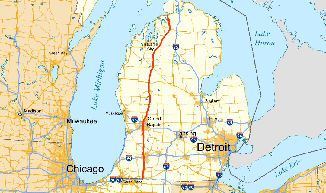
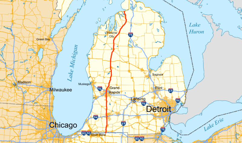
259:This file is licensed under the
251:
246:
240:
203:
84:
21:
382:
14:
696:Category:Road maps of Michigan
381:
362:GNU Free Documentation License
351:GNU Free Documentation License
341:GNU Free Documentation License
26:
1:
31:
407:Items portrayed in this file
775:
302:same or compatible license
172:(urban areas, local roads)
628:
160:(land, water, boundaries)
16:
384:
346:Free Software Foundation
268:
91:This is a file from the
685:
184:
151:
144:
141:
127:
95:. Information from its
130:US Highway 131 map.png
98:description page there
41:Size of this preview:
731:Horizontal resolution
664:19:20, 29 August 2014
195:PNG development
166:(parks, city points)
739:Vertical resolution
283:– to adapt the work
47:Other resolutions:
471:author name string
456:Wikimedia username
164:Natural Earth Data
57:1,080 × 640 pixels
762:
761:
712:Northern Michigan
700:
548:copyright license
393:
373:
372:
225:
224:
214:was created with
113:
112:
93:Wikimedia Commons
766:
756:
754:www.inkscape.org
728:
688:U.S. Highway 131
676:
512:copyright status
493:
488:
478:
475:
465:
460:
369:
366:
363:
360:
357:
335:
334:
328:
324:
321:
318:
315:
312:
304:as the original.
261:Creative Commons
255:
254:
250:
249:
244:
243:
207:
170:US Census Bureau
147:
136:U.S. Highway 131
131:
125:
109:
88:
87:
81:
75:
73:
60:
53:640 × 379 pixels
49:320 × 190 pixels
43:800 × 474 pixels
774:
773:
769:
768:
767:
765:
764:
763:
752:
716:
708:
701:
682:
674:
630:
629:
626:
625:
624:
623:
622:
621:
620:
619:
617:
607:
606:
605:
603:
592:
591:
590:
589:
588:
587:
586:
585:
583:
572:
571:
570:
569:
568:
566:
554:
553:
552:
550:
539:
538:
537:
536:
535:
534:
533:
532:
530:
518:
517:
516:
514:
503:
502:
501:
500:
499:
498:
497:
496:
495:
494:
489:
486:
480:
479:
476:
473:
467:
466:
461:
458:
449:
448:
447:
445:
435:
434:
433:
431:
420:
419:
418:
417:
416:
414:
398:
397:
396:
379:
378:
377:
367:
364:
361:
358:
355:
326:
325:
322:
319:
316:
313:
310:
309:
267:
256:
237:
236:
231:
226:
221:
220:
219:
198:
129:
122:
115:
114:
103:
102:
101:is shown below.
77:
71:
69:
62:
61:
46:
12:
11:
5:
772:
770:
760:
759:
758:
757:
748:
744:
743:
740:
736:
735:
732:
719:
715:
714:
706:
705:
704:
699:
698:
684:
680:
677:
671:
666:
661:
657:
656:
653:
650:
647:
644:
641:
634:
633:
618:
616:29 August 2014
615:
613:
612:
611:
610:
609:
608:
604:
599:
597:
596:
595:
594:
593:
584:
579:
577:
576:
575:
574:
573:
567:
562:
560:
559:
558:
557:
556:
555:
551:
546:
544:
543:
542:
541:
540:
531:
526:
524:
523:
522:
521:
520:
519:
515:
510:
508:
507:
506:
505:
504:
482:
481:
469:
468:
454:
453:
452:
451:
450:
446:
443:
441:
440:
439:
438:
437:
436:
432:
427:
425:
424:
423:
422:
421:
415:
410:
408:
405:
404:
403:
402:
401:
390:
389:
386:
383:
374:
371:
370:
336:
308:
307:
306:
305:
295:
286:
285:
284:
278:
271:You are free:
258:
257:
239:
233:
232:
230:
227:
223:
222:
202:
201:
199:
196:
192:
191:
186:
182:
181:
180:
179:
173:
167:
161:
158:National Atlas
153:
149:
148:
146:29 August 2014
143:
139:
138:
132:
123:
121:
118:
116:
111:
110:
89:
79:
78:
40:
36:
35:
34:
29:
24:
19:
13:
10:
9:
6:
4:
3:
2:
771:
755:
751:
749:
747:Software used
746:
741:
738:
733:
730:
726:
723:
717:
713:
710:
702:
697:
693:
689:
683:
678:
672:
670:
667:
665:
662:
659:
658:
654:
651:
648:
645:
642:
640:
639:
637:
631:
602:
582:
565:
549:
529:
513:
492:
485:
472:
464:
457:
430:
413:
353:
352:
347:
343:
342:
337:
330:
329:
314:CC BY-SA 3.0
303:
299:
296:
293:
290:
289:
287:
282:
279:
276:
273:
272:
270:
269:
265:
262:
245:
228:
217:
213:
206:
200:
194:
193:
190:
187:
183:
178:(major roads)
177:
174:
171:
168:
165:
162:
159:
156:
155:
154:
150:
140:
137:
133:
126:
119:
107:
100:
99:
94:
90:
83:
82:
76:
67:
66:Original file
58:
54:
50:
44:
39:
33:
30:
28:
25:
23:
20:
18:
15:
724:
721:
673:1,080 × 640
635:
632:File history
349:
339:
297:
291:
280:
274:
106:You can help
96:
64:
22:File history
528:copyrighted
298:share alike
292:attribution
128:Description
703:File usage
649:Dimensions
444:some value
27:File usage
742:35.43 dpc
734:35.43 dpc
646:Thumbnail
643:Date/Time
601:inception
229:Licensing
197:InfoField
72:image/png
718:Metadata
692:Fredddie
681:Fredddie
675:(431 KB)
477:Fredddie
463:Fredddie
388:Captions
281:to remix
275:to share
266:license.
189:Fredddie
32:Metadata
660:current
655:Comment
429:creator
412:depicts
392:English
134:Map of
120:Summary
68:
210:This
208:
185:Author
152:Source
652:User
368:true
365:true
359:GFDL
323:true
320:true
216:QGIS
142:Date
17:File
484:URL
212:map
487::
474::
459::
55:|
51:|
45:.
354:.
218:.
108:.
74:)
59:.
Text is available under the Creative Commons Attribution-ShareAlike License. Additional terms may apply.