271:
193:
72:
126:
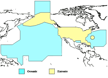
A map of the regions where the United States charges overflight fees. Yellow is where higher "enroute" fees are charged. Blue is where "oceanic" fees are charged. The colored regions of this map correspond to the regions where the US has delegated authority by the ICAO to control air traffic,
320:
43:
376:
209:
205:
201:
154:
366:
83:
51:
457:
This file contains additional information, probably added from the digital camera or scanner used to create or digitize it.
480:
381:
144:
351:
460:
If the file has been modified from its original state, some details may not fully reflect the modified file.
347:
The following pages on the
English Knowledge (XXG) use this file (pages on other projects are not listed):
261:
444:
371:
361:
91:
319:
314:
42:
78:
424:
330:
434:
419:
214:
145:
http://www.faa.gov/about/office_org/headquarters_offices/aba/overflight_fees/
409:
399:
248:
256:
252:
244:
240:
236:
232:
228:
224:
356:
204:
employee, taken or made as part of that person's official duties. As a
287:
Click on a date/time to view the file as it appeared at that time.
187:
66:
269:
110:
90:
Commons is a freely licensed media file repository.
56:(375 × 272 pixels, file size: 28 KB, MIME type:
377:United States government role in civil aviation
71:
8:
462:
289:
260:
167:
392:The following other wikis use this file:
469:xmp.did:7C9FB1AE106BE211AEE4EC6AE6D50824
477:
472:
464:
425:Utente:Parsec09/Freedoms of the air (1)
349:
192:
7:
127:including over international waters.
420:Utente:Parsec09/Freedoms of the air
337:User created page with UploadWizard
455:
200:This image or file is a work of a
198:
120:
103:
49:
191:
70:
31:
21:
410:Federal Aviation Administration
367:Federal Aviation Administration
202:Federal Aviation Administration
155:Federal Aviation Administration
121:
46:No higher resolution available.
14:
466:Unique ID of original document
400:Federale Lugvaartadministrasie
26:
1:
36:
481:Adobe Photoshop CS5 Windows
502:
441:Usage on zh.wikipedia.org
431:Usage on ja.wikipedia.org
416:Usage on it.wikipedia.org
406:Usage on fr.wikipedia.org
396:Usage on af.wikipedia.org
382:User:Vigneshdm1990/sandbox
116:US Overflight Fee Map.png
52:US_Overflight_Fee_Map.png
16:
352:Air Traffic Organization
77:This is a file from the
336:
210:U.S. federal government
150:
140:
135:
132:
113:
81:. Information from its
274:
212:, the image is in the
84:description page there
273:
218:in the United States.
315:02:52, 9 August 2014
372:Freedoms of the air
362:Area control center
275:
489:
488:
388:Global file usage
340:
279:
278:
264:
186:
185:
160:
159:
99:
98:
79:Wikimedia Commons
32:Global file usage
493:
483:
463:
327:
272:
265:
195:
194:
188:
182:
179:
176:
173:
168:
125:
117:
111:
95:
74:
73:
67:
61:
59:
501:
500:
496:
495:
494:
492:
491:
490:
479:
451:
386:
348:
341:
333:
325:
281:
280:
270:
223:
220:
180:
177:
174:
171:
166:
161:
128:
115:
108:
101:
100:
89:
88:
87:is shown below.
63:
57:
55:
48:
47:
12:
11:
5:
499:
497:
487:
486:
485:
484:
475:
471:
470:
467:
454:
450:
449:
448:
447:
439:
438:
437:
429:
428:
427:
422:
414:
413:
412:
404:
403:
402:
390:
389:
385:
384:
379:
374:
369:
364:
359:
354:
346:
345:
344:
339:
338:
335:
331:
328:
322:
317:
312:
308:
307:
304:
301:
298:
295:
292:
285:
284:
277:
276:
267:
196:
184:
183:
165:
162:
158:
157:
152:
148:
147:
142:
138:
137:
134:
130:
129:
118:
109:
107:
104:
102:
97:
96:
75:
65:
64:
45:
41:
40:
39:
34:
29:
24:
19:
13:
10:
9:
6:
4:
3:
2:
498:
482:
478:
476:
474:Software used
473:
468:
465:
461:
458:
452:
446:
443:
442:
440:
436:
433:
432:
430:
426:
423:
421:
418:
417:
415:
411:
408:
407:
405:
401:
398:
397:
395:
394:
393:
387:
383:
380:
378:
375:
373:
370:
368:
365:
363:
360:
358:
355:
353:
350:
342:
334:
329:
323:
321:
318:
316:
313:
310:
309:
305:
302:
299:
296:
293:
291:
290:
288:
282:
268:
266:
263:
258:
254:
250:
246:
242:
238:
234:
230:
226:
221:
219:
217:
216:
215:public domain
211:
207:
203:
197:
190:
189:
175:Public domain
172:Public domain
170:
169:
163:
156:
153:
149:
146:
143:
139:
131:
124:
119:
112:
105:
93:
86:
85:
80:
76:
69:
68:
62:
53:
44:
38:
35:
33:
30:
28:
25:
23:
20:
18:
15:
459:
456:
391:
286:
283:File history
222:
213:
199:
136:Unknown date
122:
92:You can help
82:
50:
22:File history
114:Description
343:File usage
324:375 × 272
300:Dimensions
253:українська
241:Nederlands
233:македонски
27:File usage
297:Thumbnail
294:Date/Time
249:sicilianu
164:Licensing
123:English:
58:image/png
453:Metadata
357:Airspace
259: |
255: |
251: |
247: |
243: |
239: |
235: |
231: |
229:italiano
227: |
37:Metadata
332:AHeneen
326:(28 KB)
311:current
306:Comment
245:русский
225:English
208:of the
106:Summary
54:
445:跨太平洋飛行
237:മലയാളം
151:Author
141:Source
181:false
178:false
435:空の自由
303:User
206:work
133:Date
17:File
262:+/−
257:中文
94:.
60:)
Text is available under the Creative Commons Attribution-ShareAlike License. Additional terms may apply.