167:
140:
173:
67:
141:
http://nationalatlas.gov/natlas/Natlasstart.asp?AppCmd=CUSTOM&mLeft=-1463542.35271811&mBottom=207028.2604466&mRight=-1383241.65436944&mTop=264467.958836208&mWidth=721&mHeight=522&LonLat=null&bgoff=T&tabs=T&LayerList=CitiesTowns,Counties,Roads,sf,us,States,LakesRivers,indlan,wa,USUrban,Airports,FederalTr,Rail
423:{{Information |Description={{en|1=Map of Umatilla Indian Reservation and vicinity}} |Source=http://nationalatlas.gov/natlas/Natlasstart.asp?AppCmd=CUSTOM&mLeft=-1463542.35271811&mBottom=207028.2604466&mRight=-1383241.65436944&mTop=264467.958836208&mWidth=
406:
194:
by waiving all of their rights to the work worldwide under copyright law, including all related and neighboring rights, to the extent allowed by law. You can copy, modify, distribute and perform the work, even for commercial purposes, all without asking permission.
38:
437:
78:
46:
281:
317:
265:
442:
337:
301:
248:
433:
The following pages on the
English Knowledge (XXG) use this file (pages on other projects are not listed):
405:
400:
179:
37:
460:
86:
191:
416:
182:
73:
130:
190:
The person who associated a work with this deed has dedicated the work to the
465:
485:
475:
373:
Click on a date/time to view the file as it appeared at that time.
282:
copyrighted, dedicated to the public domain by copyright holder
161:
61:
198:
http://creativecommons.org/publicdomain/zero/1.0/deed.en
232:
Add a one-line explanation of what this file represents
438:
Confederated Tribes of the
Umatilla Indian Reservation
495:
105:
85:
Commons is a freely licensed media file repository.
461:Tribus Confederades de la Reserva índia Umatilla
51:(794 × 542 pixels, file size: 18 KB, MIME type:
204:Creative Commons Zero, Public Domain Dedication
150:Pete Forsyth, using U.S Federal Government tool
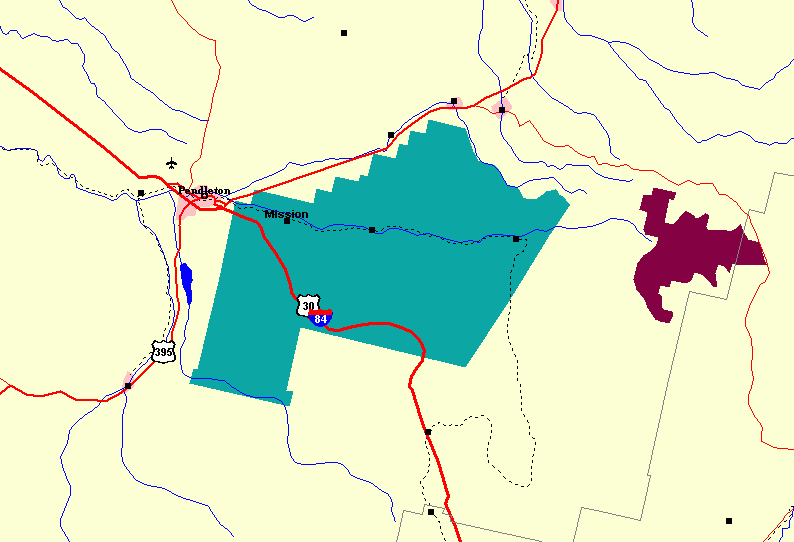
121:Map of Umatilla Indian Reservation and vicinity
66:
8:
375:
228:
183:CC0 1.0 Universal Public Domain Dedication
453:The following other wikis use this file:
166:
435:
351:
335:
315:
299:
279:
263:
246:
243:
224:
217:
178:This file is made available under the
7:
364:
111:Umatilla Indian Reservation map.png
47:Umatilla_Indian_Reservation_map.png
237:
231:
115:
98:
44:
236:
222:
171:
165:
65:
31:
21:
219:
172:
116:
41:No higher resolution available.
14:
218:
26:
1:
318:Creative Commons CC0 License
244:Items portrayed in this file
443:Umatilla Indian Reservation
514:
492:Usage on www.wikidata.org
482:Usage on it.wikipedia.org
472:Usage on hu.wikipedia.org
457:Usage on ca.wikipedia.org
365:
164:
16:
486:Riserva indiana Umatilla
401:16:38, 19 September 2009
221:
72:This is a file from the
422:
146:
136:
129:
126:
108:
76:. Information from its
466:Reserva índia Umatilla
79:description page there
476:Umatilla rezervátum
449:Global file usage
426:
353:19 September 2009
302:copyright license
230:
216:
215:
154:
153:
131:19 September 2009
94:
93:
74:Wikimedia Commons
32:Global file usage
505:
413:
266:copyright status
211:
208:
205:
202:
199:
180:Creative Commons
175:
174:
169:
168:
162:
132:
120:
112:
106:
90:
69:
68:
62:
56:
54:
513:
512:
508:
507:
506:
504:
503:
502:
447:
434:
427:
419:
411:
367:
366:
363:
362:
361:
360:
359:
358:
357:
356:
354:
344:
343:
342:
340:
329:
328:
327:
326:
325:
324:
323:
322:
320:
308:
307:
306:
304:
293:
292:
291:
290:
289:
288:
287:
286:
284:
272:
271:
270:
268:
257:
256:
255:
254:
253:
251:
235:
234:
233:
209:
206:
203:
200:
197:
160:
155:
122:
110:
103:
96:
95:
84:
83:
82:is shown below.
58:
52:
50:
43:
42:
12:
11:
5:
511:
509:
501:
500:
499:
498:
490:
489:
488:
480:
479:
478:
470:
469:
468:
463:
451:
450:
446:
445:
440:
432:
431:
430:
425:
424:
421:
417:
414:
408:
403:
398:
394:
393:
390:
387:
384:
381:
378:
371:
370:
355:
352:
350:
349:
348:
347:
346:
345:
341:
336:
334:
333:
332:
331:
330:
321:
316:
314:
313:
312:
311:
310:
309:
305:
300:
298:
297:
296:
295:
294:
285:
280:
278:
277:
276:
275:
274:
273:
269:
264:
262:
261:
260:
259:
258:
252:
247:
245:
242:
241:
240:
239:
238:
227:
226:
223:
220:
214:
213:
187:
186:
176:
159:
156:
152:
151:
148:
144:
143:
138:
134:
133:
128:
124:
123:
113:
104:
102:
99:
97:
92:
91:
70:
60:
59:
40:
36:
35:
34:
29:
24:
19:
13:
10:
9:
6:
4:
3:
2:
510:
497:
494:
493:
491:
487:
484:
483:
481:
477:
474:
473:
471:
467:
464:
462:
459:
458:
456:
455:
454:
448:
444:
441:
439:
436:
428:
420:
415:
409:
407:
404:
402:
399:
396:
395:
391:
388:
385:
382:
379:
377:
376:
374:
368:
339:
319:
303:
283:
267:
250:
212:
193:
192:public domain
189:
188:
184:
181:
177:
163:
157:
149:
145:
142:
139:
135:
125:
119:
114:
107:
100:
88:
81:
80:
75:
71:
64:
63:
57:
48:
39:
33:
30:
28:
25:
23:
20:
18:
15:
452:
372:
369:File history
196:
117:
87:You can help
77:
45:
22:File history
418:Peteforsyth
109:Description
429:File usage
410:794 × 542
386:Dimensions
27:File usage
383:Thumbnail
380:Date/Time
338:inception
158:Licensing
118:English:
53:image/png
496:Q7881199
225:Captions
412:(18 KB)
397:current
392:Comment
249:depicts
229:English
101:Summary
49:
170:
147:Author
137:Source
210:false
207:false
389:User
127:Date
17:File
201:CC0
185:.
89:.
55:)
Text is available under the Creative Commons Attribution-ShareAlike License. Additional terms may apply.