187:
38:
152:
94:
172:
UN maps are, in principle, open source material and you can use them in your work or for making your own map. UN requests however that you delete the UN name, logo and reference number upon any modification to the map. Content of your map will be your responsibility. You can state in your
236:
458:
503:
270:
513:
313:
174:
173:
publication, if you wish, something like: based on UN map … (map name, map number, revision number and date). See:
254:
483:
60:
56:
52:
48:
42:
105:
73:
166:
Unless stated otherwise, UN maps are to be considered in the public domain. This applies worldwide.
275:
113:
383:
368:
473:
463:
453:
443:
438:
388:
358:
100:
293:
448:
428:
353:
159:
246:
235:
230:
178:
64:
37:
186:
493:
303:
169:
Some UN maps have special copyrights, as indicated on the map itself.
328:
203:
Click on a date/time to view the file as it appeared at that time.
433:
146:
88:
185:
478:
468:
418:
403:
393:
423:
78:(2,348 × 2,947 pixels, file size: 1.48 MB, MIME type:
413:
408:
398:
378:
373:
363:
348:
318:
338:
112:
Commons is a freely licensed media file repository.
93:
8:
179:Geospatial, location data for a better world
271:List of cities and largest towns in Bolivia
205:
126:
286:The following other wikis use this file:
268:
266:The following 2 pages use this file:
151:
7:
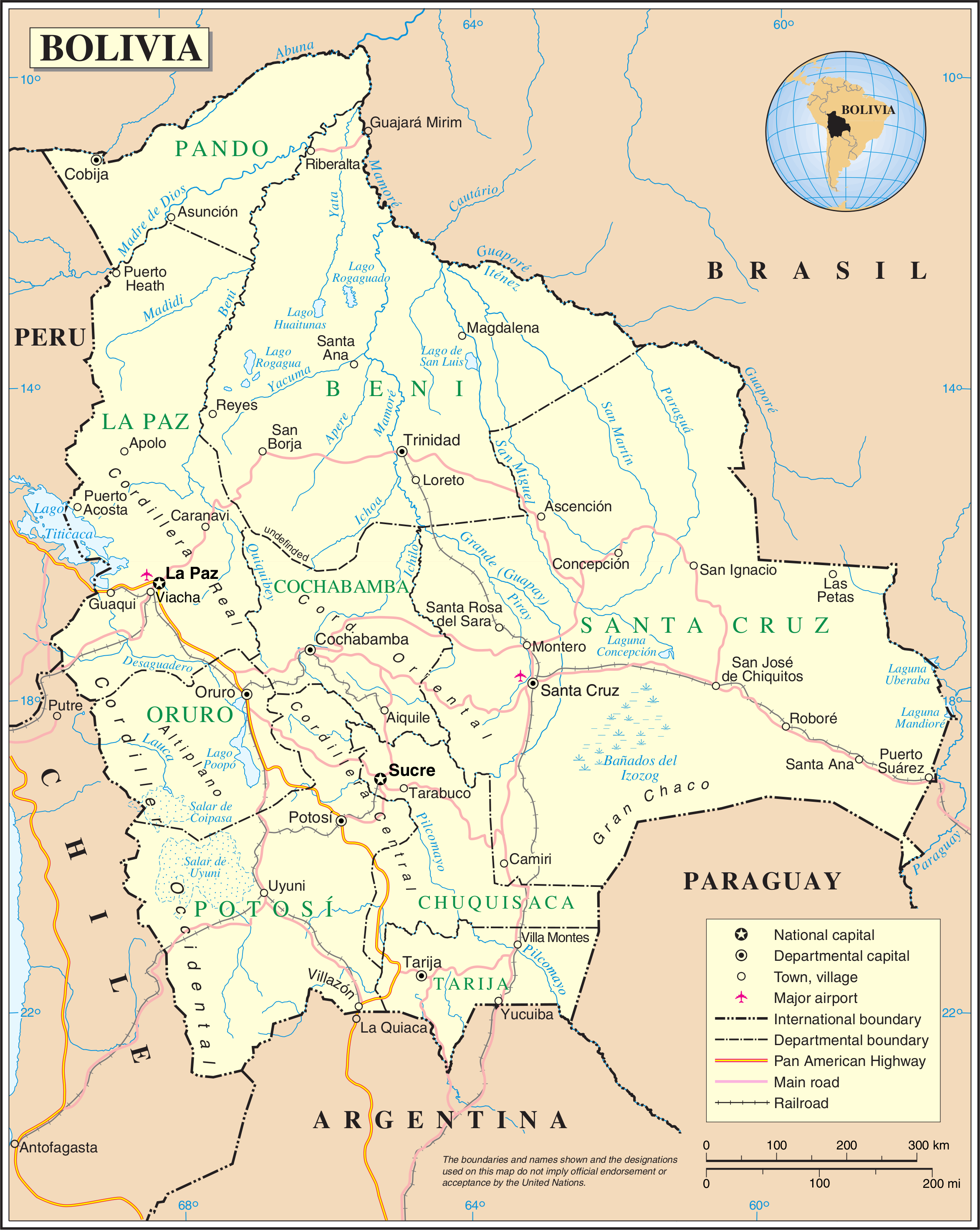
157:This image is a map derived from a
125:
71:
150:
92:
31:
21:
14:
175:Geospatial Information Section
26:
1:
294:Bolivianische Grenzübergänge
345:Usage on pl.wiktionary.org
310:Usage on gom.wikipedia.org
532:
510:Usage on uk.wikipedia.org
500:Usage on ru.wikipedia.org
490:Usage on pt.wikipedia.org
335:Usage on nl.wikipedia.org
325:Usage on id.wikipedia.org
300:Usage on es.wikipedia.org
290:Usage on de.wikipedia.org
16:
255:Category:Maps of Bolivia
99:This is a file from the
252:
103:. Information from its
504:Список городов Боливии
494:Subdivisões da Bolívia
329:Daftar kota di Bolivia
231:02:52, 23 October 2007
190:
106:description page there
41:Size of this preview:
189:
65:2,348 × 2,947 pixels
304:Río Piraí (Bolivia)
47:Other resolutions:
276:Outline of Bolivia
191:
61:816 × 1,024 pixels
514:Географія Болівії
282:Global file usage
259:
195:
194:
145:
144:
121:
120:
101:Wikimedia Commons
32:Global file usage
523:
243:
154:
153:
147:
141:
138:
135:
132:
127:
117:
96:
95:
89:
83:
81:
68:
57:612 × 768 pixels
53:382 × 480 pixels
49:191 × 240 pixels
43:478 × 600 pixels
531:
530:
526:
525:
524:
522:
521:
520:
280:
260:
249:
241:
197:
196:
139:
136:
133:
130:
123:
122:
111:
110:
109:is shown below.
85:
79:
77:
70:
69:
46:
12:
11:
5:
529:
527:
519:
518:
517:
516:
508:
507:
506:
498:
497:
496:
488:
487:
486:
481:
476:
471:
466:
461:
459:ประเทศโบลิเวีย
456:
451:
446:
441:
436:
431:
426:
421:
416:
411:
406:
401:
396:
391:
386:
381:
376:
371:
366:
361:
356:
351:
343:
342:
341:
333:
332:
331:
323:
322:
321:
316:
308:
307:
306:
298:
297:
296:
284:
283:
279:
278:
273:
264:
263:
258:
257:
251:
247:
244:
240:2,348 × 2,947
238:
233:
228:
224:
223:
220:
217:
214:
211:
208:
201:
200:
193:
192:
183:
160:United Nations
155:
143:
142:
124:
119:
118:
97:
87:
86:
40:
36:
35:
34:
29:
24:
19:
13:
10:
9:
6:
4:
3:
2:
528:
515:
512:
511:
509:
505:
502:
501:
499:
495:
492:
491:
489:
485:
482:
480:
477:
475:
472:
470:
467:
465:
462:
460:
457:
455:
452:
450:
447:
445:
442:
440:
437:
435:
432:
430:
427:
425:
422:
420:
417:
415:
412:
410:
407:
405:
402:
400:
397:
395:
392:
390:
387:
385:
382:
380:
377:
375:
372:
370:
367:
365:
362:
360:
357:
355:
352:
350:
347:
346:
344:
340:
337:
336:
334:
330:
327:
326:
324:
320:
317:
315:
312:
311:
309:
305:
302:
301:
299:
295:
292:
291:
289:
288:
287:
281:
277:
274:
272:
269:
267:
261:
256:
250:
245:
239:
237:
234:
232:
229:
226:
225:
221:
218:
215:
212:
209:
207:
206:
204:
198:
188:
184:
182:
180:
176:
170:
168:
167:
162:
161:
156:
149:
148:
134:Public domain
131:Public domain
129:
128:
115:
108:
107:
102:
98:
91:
90:
84:
75:
74:Original file
66:
62:
58:
54:
50:
44:
39:
33:
30:
28:
25:
23:
20:
18:
15:
285:
265:
253:{{UN map}}
202:
199:File history
171:
165:
164:
158:
114:You can help
104:
72:
22:File history
314:बोलिव्हिया
262:File usage
216:Dimensions
27:File usage
242:(1.48 MB)
213:Thumbnail
210:Date/Time
80:image/png
479:Bolīvija
424:Bolivija
384:Боливија
369:بولىۋىيە
484:ବୋଲିଭିଆ
474:بوليفية
469:Volívia
464:Բոլիվիա
454:بوليفيا
444:Болівія
439:Балівія
434:Bólivía
419:Bolívie
414:Bolivie
409:Bolivya
404:Bolívia
399:Bolivio
394:Bolivië
389:Βολιβία
379:Bolibia
374:Wuliwya
364:Boliwia
359:Боливия
349:Bolivia
339:Bolivia
319:Bolivia
227:current
222:Comment
177:. And:
76:
449:بولیوی
248:Jeroen
163:map.
140:false
137:false
429:玻利维亚
354:ボリビア
219:User
17:File
181:.
63:|
59:|
55:|
51:|
45:.
116:.
82:)
67:.
Text is available under the Creative Commons Attribution-ShareAlike License. Additional terms may apply.
