187:
152:
38:
94:
172:
UN maps are, in principle, open source material and you can use them in your work or for making your own map. UN requests however that you delete the UN name, logo and reference number upon any modification to the map. Content of your map will be your responsibility. You can state in your
538:
543:
236:
473:
578:
573:
398:
174:
173:
publication, if you wish, something like: based on UN map … (map name, map number, revision number and date). See:
254:
393:
383:
266:
The following pages on the
English Knowledge (XXG) use this file (pages on other projects are not listed):
60:
56:
52:
48:
42:
105:
73:
413:
403:
388:
166:
Unless stated otherwise, UN maps are to be considered in the public domain. This applies worldwide.
113:
275:
270:
493:
363:
100:
503:
478:
468:
159:
246:
178:
235:
230:
186:
64:
37:
498:
558:
553:
488:
328:
169:
Some UN maps have special copyrights, as indicated on the map itself.
348:
203:
Click on a date/time to view the file as it appeared at that time.
563:
373:
513:
453:
146:
88:
185:
313:
508:
353:
78:(2,057 × 2,820 pixels, file size: 1.19 MB, MIME type:
518:
598:
588:
483:
463:
433:
423:
338:
318:
293:
112:
Commons is a freely licensed media file repository.
528:
443:
303:
93:
8:
179:Geospatial, location data for a better world
205:
126:
364:Projet:Cartographie/Cartes standards/Pays
286:The following other wikis use this file:
268:
539:История почты и почтовых марок Малави
151:
7:
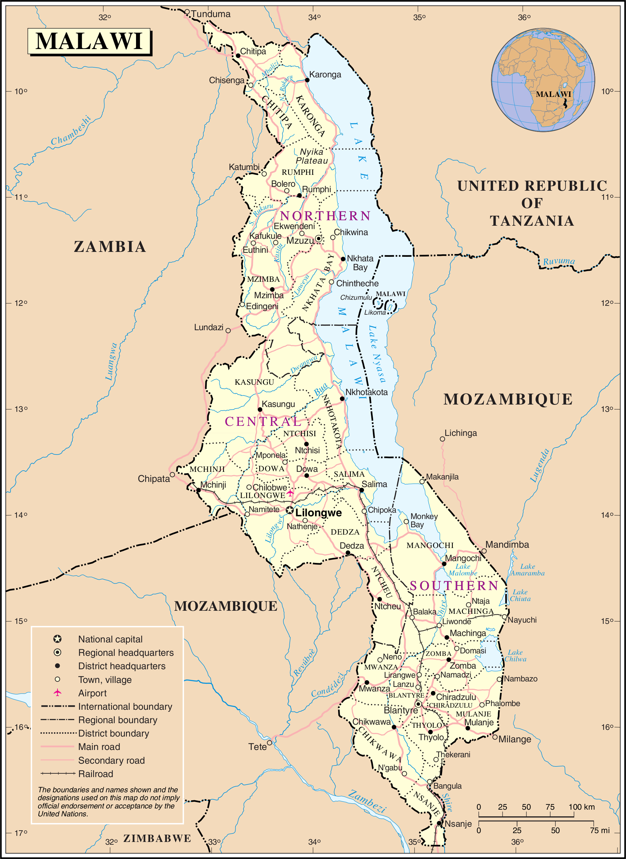
157:This image is a map derived from a
544:Железнодорожный транспорт в Малави
125:
71:
150:
92:
31:
21:
14:
175:Geospatial Information Section
26:
1:
595:Usage on zea.wikipedia.org
585:Usage on vls.wikipedia.org
559:User talk:Outline of Malawi
554:User talk:History of Malawi
550:Usage on tum.wikipedia.org
460:Usage on pl.wiktionary.org
430:Usage on nds.wikipedia.org
310:Usage on bar.wikipedia.org
290:Usage on ast.wikipedia.org
617:
570:Usage on uk.wikipedia.org
535:Usage on ru.wikipedia.org
525:Usage on ro.wikipedia.org
450:Usage on no.wikipedia.org
440:Usage on nl.wikipedia.org
420:Usage on lt.wikipedia.org
410:Usage on ko.wikipedia.org
380:Usage on ja.wikipedia.org
370:Usage on it.wikipedia.org
360:Usage on fr.wikipedia.org
345:Usage on es.wikipedia.org
335:Usage on eo.wikipedia.org
325:Usage on de.wikipedia.org
300:Usage on az.wikipedia.org
329:Schienenverkehr in Malawi
16:
99:This is a file from the
255:Category:Maps of Malawi
252:
103:. Information from its
231:01:30, 24 October 2007
190:
106:description page there
41:Size of this preview:
189:
374:Distretti del Malawi
65:2,057 × 2,820 pixels
349:Geografía de Malaui
47:Other resolutions:
191:
61:747 × 1,024 pixels
474:Республика Малави
454:Jernbane i Malawi
282:Global file usage
276:Outline of Malawi
271:History of Malawi
259:
195:
194:
145:
144:
121:
120:
101:Wikimedia Commons
32:Global file usage
608:
579:Географія Малаві
574:Транспорт Малаві
243:
154:
153:
147:
141:
138:
135:
132:
127:
117:
96:
95:
89:
83:
81:
68:
57:560 × 768 pixels
53:350 × 480 pixels
49:175 × 240 pixels
43:437 × 599 pixels
616:
615:
611:
610:
609:
607:
606:
605:
564:Mbili ya Malaŵi
280:
267:
260:
249:
241:
197:
196:
139:
136:
133:
130:
123:
122:
111:
110:
109:is shown below.
85:
79:
77:
70:
69:
46:
12:
11:
5:
614:
612:
604:
603:
602:
601:
593:
592:
591:
583:
582:
581:
576:
568:
567:
566:
561:
556:
548:
547:
546:
541:
533:
532:
531:
523:
522:
521:
516:
511:
506:
501:
496:
491:
486:
481:
476:
471:
466:
458:
457:
456:
448:
447:
446:
438:
437:
436:
428:
427:
426:
418:
417:
416:
408:
407:
406:
401:
396:
391:
386:
378:
377:
376:
368:
367:
366:
358:
357:
356:
351:
343:
342:
341:
333:
332:
331:
323:
322:
321:
316:
308:
307:
306:
298:
297:
296:
284:
283:
279:
278:
273:
265:
264:
263:
258:
257:
251:
247:
244:
240:2,057 × 2,820
238:
233:
228:
224:
223:
220:
217:
214:
211:
208:
201:
200:
193:
192:
183:
160:United Nations
155:
143:
142:
124:
119:
118:
97:
87:
86:
40:
36:
35:
34:
29:
24:
19:
13:
10:
9:
6:
4:
3:
2:
613:
600:
597:
596:
594:
590:
587:
586:
584:
580:
577:
575:
572:
571:
569:
565:
562:
560:
557:
555:
552:
551:
549:
545:
542:
540:
537:
536:
534:
530:
527:
526:
524:
520:
517:
515:
512:
510:
507:
505:
502:
500:
497:
495:
492:
490:
487:
485:
482:
480:
477:
475:
472:
470:
467:
465:
462:
461:
459:
455:
452:
451:
449:
445:
442:
441:
439:
435:
432:
431:
429:
425:
422:
421:
419:
415:
412:
411:
409:
405:
402:
400:
397:
395:
392:
390:
387:
385:
382:
381:
379:
375:
372:
371:
369:
365:
362:
361:
359:
355:
352:
350:
347:
346:
344:
340:
337:
336:
334:
330:
327:
326:
324:
320:
317:
315:
314:ISO 3166-2:MW
312:
311:
309:
305:
302:
301:
299:
295:
292:
291:
289:
288:
287:
281:
277:
274:
272:
269:
261:
256:
253:{{UN map}}
250:
245:
239:
237:
234:
232:
229:
226:
225:
221:
218:
215:
212:
209:
207:
206:
204:
198:
188:
184:
182:
180:
176:
170:
168:
167:
162:
161:
156:
149:
148:
134:Public domain
131:Public domain
129:
128:
115:
108:
107:
102:
98:
91:
90:
84:
75:
74:Original file
66:
62:
58:
54:
50:
44:
39:
33:
30:
28:
25:
23:
20:
18:
15:
285:
202:
199:File history
171:
165:
164:
158:
114:You can help
104:
72:
22:File history
399:マラウイの鉄道駅一覧
354:Costa seca
262:File usage
216:Dimensions
27:File usage
242:(1.19 MB)
213:Thumbnail
210:Date/Time
80:image/png
514:Malááwii
519:Malavio
494:Μαλάουι
424:Malavis
414:말라위의 역사
394:マラウイの鉄道
384:マラウイの地理
339:Malavio
227:current
222:Comment
177:. And:
76:
599:Malawi
589:Malawi
529:Malawi
509:Malaŵi
504:Մալավի
484:Malaui
479:Малаві
469:Малави
464:Malawi
444:Malawi
434:Malawi
404:ドワングワ川
389:マラウイ鉄道
319:Malawi
304:Malavi
294:Malaui
248:Jeroen
499:ملاوي
163:map.
140:false
137:false
219:User
17:File
489:말라위
181:.
63:|
59:|
55:|
51:|
45:.
116:.
82:)
67:.
Text is available under the Creative Commons Attribution-ShareAlike License. Additional terms may apply.
