43:
264:
222:
355:
236:
1003:
270:
973:
275:
91:
158:
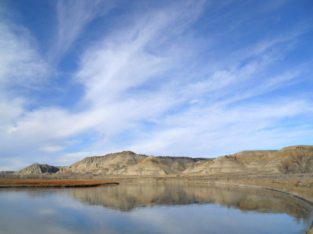
Here the river is deep as it flows along the north shore. Steamboats could get in close to shore to offload their cargos. Cargos were dropped at the Cow Island
Landing during the steamboat era on the Missouri (1860 to mid 1880's), during the summer and fall when the river got too low for steamboats
57:
53:
47:
213:
70:
102:
1020:{{Information |Description={{en|1=In the middle of the photo is the upper Cow Island Landing, above the mouth of Cow Creek. Here the river is deep as it flows along the north shore. There was another landing site below the mouth of Cow Creek, down at the
1039:
316:– You must give appropriate credit, provide a link to the license, and indicate if changes were made. You may do so in any reasonable manner, but not in any way that suggests the licensor endorses you or your use.
162:
The site of the pictured upper landing is on the river bank just in front of the Kipp
Homestead buildings. Reportedly a snubbing post (to tie up steamboats) was embedded in the bank at this site for many
1002:
997:
159:
to get all the way up to Ft. Benton, 120 mile upstream. There was another lower landing site below the mouth of Cow Creek, downriver at the location of Cow island.
972:
967:
61:
42:
372:
196:
370:; with no Invariant Sections, no Front-Cover Texts, and no Back-Cover Texts. A copy of the license is included in the section entitled
362:
672:
602:
585:
549:
229:
1257:
1070:
This file contains additional information, probably added from the digital camera or scanner used to create or digitize it.
884:
323:
484:
146:
904:
834:
797:
763:
726:
692:
656:
533:
505:
492:
477:
367:
622:
569:
450:
433:
1226:
868:
512:
285:
150:
1073:
If the file has been modified from its original state, some details may not fully reflect the modified file.
1030:
The following pages on the
English Knowledge (XXG) use this file (pages on other projects are not listed):
1323:
322:– If you remix, transform, or build upon the material, you must distribute your contributions under the
1057:
1013:
282:
1359:
1034:
110:
1464:
349:
360:
Permission is granted to copy, distribute and/or modify this document under the terms of the
135:
Upper Cow Island
Landing, above the mouth of Cow Creek, in the Missouri Breaks, Montana.jpg
235:
247:
The coordiantes of the site of this upper landing are 47°47'34.26"N, 108°56'26.23"W.
1419:
1341:
1305:
1099:
257:
I, the copyright holder of this work, hereby publish it under the following licenses:
97:
1474:
1429:
1139:
1092:
219:
1377:
176:
1119:
983:
1484:
1109:
1040:
National
Register of Historic Places listings in Blaine County, Montana
940:
Click on a date/time to view the file as it appeared at that time.
685:
1082:
145:
In the middle of the photo is the upper Cow Island
Landing of the
214:
47° 47′ 34.26″ N, 108° 56′ 26.23″ W
221:
204:
85:
417:
Add a one-line explanation of what this file represents
603:
Creative
Commons Attribution-ShareAlike 3.0 Unported
586:
366:, Version 1.2 or any later version published by the
129:
109:
Commons is a freely licensed media file repository.
75:(1,024 × 768 pixels, file size: 290 KB, MIME type:
1364:Flash did not fire, compulsory flash suppression
333:https://creativecommons.org/licenses/by-sa/3.0
90:
339:Creative Commons Attribution-Share Alike 3.0
263:
8:
299:– to copy, distribute and transmit the work
1075:
942:
413:
398:You may select the license of your choice.
1050:The following other wikis use this file:
1516:
1508:
1500:
1492:
1482:
1472:
1462:
1454:
1446:
1438:
1427:
1417:
1409:
1401:
1393:
1385:
1375:
1367:
1357:
1349:
1339:
1331:
1321:
1313:
1303:
1295:
1274:
1266:
1255:
1247:
1239:
1231:
1221:
1213:
1205:
1197:
1189:
1181:
1163:
1155:
1147:
1136:
1128:
1117:
1107:
1097:
1087:
1032:
918:
902:
882:
866:
848:
832:
811:
795:
777:
761:
740:
724:
706:
690:
670:
654:
636:
620:
600:
583:
567:
547:
531:
464:
448:
431:
428:
409:
402:
207:
228:View this and other nearby images on:
1077:
7:
378:http://www.gnu.org/copyleft/fdl.html
286:Attribution-Share Alike 3.0 Unported
931:
274:
269:
1068:
422:
416:
397:
260:
256:
139:
122:
68:
421:
1521:6823D14284D4AFE08FA230889B69A857
1505:922C8713E4CC4B59B0724D9DA5742B97
1130:Date and time of data generation
407:
354:
353:
310:Under the following conditions:
281:This file is licensed under the
273:
268:
262:
234:
220:
89:
31:
21:
1510:Date metadata was last modified
708:47°47'34.260"N, 108°56'26.228"W
404:
140:
14:
1518:Unique ID of original document
1227:Adobe Photoshop 25.6 (Windows)
403:
384:GNU Free Documentation License
373:GNU Free Documentation License
363:GNU Free Documentation License
26:
1:
1398:A directly photographed image
693:coordinates of depicted place
673:original creation by uploader
36:
499:Montana Geographical Society
478:object of statement has role
429:Items portrayed in this file
197:Montana Geographical Society
1268:Date and time of digitizing
1538:
1440:Focal length in 35 mm film
1369:Supported Flashpix version
1054:Usage on zh.wikipedia.org
324:same or compatible license
1276:Meaning of each component
1233:File change date and time
932:
186:
147:Missouri River in Montana
16:
406:
368:Free Software Foundation
290:
96:This is a file from the
1403:Custom image processing
1271:11:57, 22 November 2009
1133:11:57, 22 November 2009
1019:
998:00:28, 14 December 2009
989:
192:
182:
175:
172:
132:
100:. Information from its
1494:Subject distance range
1297:Image compression mode
240:47.792850; -108.940619
103:description page there
46:Size of this preview:
1333:Maximum land aperture
1207:Horizontal resolution
149:, above the mouth of
1513:23:48, 16 April 2024
1390:Digital still camera
1236:21:48, 16 April 2024
1199:Number of components
968:19:51, 16 April 2024
1241:Y and C positioning
1215:Vertical resolution
1079:Camera manufacturer
1035:Cow Creek (Montana)
305:– to adapt the work
52:Other resolutions:
1448:Scene capture type
1424:Auto white balance
1165:Bits per component
506:Wikimedia username
493:author name string
62:1,024 × 768 pixels
1525:
1524:
1336:2.9 APEX (f/2.73)
1183:Pixel composition
1104:1/500 sec (0.002)
1046:Global file usage
1023:
990:Removed watermark
570:copyright license
415:
395:
394:
245:
244:
202:
201:
118:
117:
98:Wikimedia Commons
32:Global file usage
1529:
1249:Exposure Program
1076:
1010:
980:
816:
745:
638:22 November 2009
534:copyright status
515:
510:
500:
497:
487:
482:
391:
388:
385:
382:
379:
357:
356:
350:
346:
343:
340:
337:
334:
326:as the original.
283:Creative Commons
277:
276:
272:
271:
266:
265:
241:
238:
224:
223:
217:
216:
205:
188:
178:
177:22 November 2009
144:
136:
130:
114:
93:
92:
86:
80:
78:
65:
58:640 × 480 pixels
54:320 × 240 pixels
48:800 × 600 pixels
1537:
1536:
1532:
1531:
1530:
1528:
1527:
1526:
1502:Unique image ID
1479:High saturation
1064:
1044:
1031:
1024:
1016:
1008:
986:
978:
934:
933:
930:
929:
928:
927:
926:
925:
924:
923:
921:
911:
910:
909:
907:
896:
895:
894:
893:
892:
891:
890:
889:
887:
875:
874:
873:
871:
860:
859:
858:
857:
856:
855:
854:
853:
851:
841:
840:
839:
837:
826:
825:
824:
823:
822:
821:
820:
819:
817:
814:
804:
803:
802:
800:
789:
788:
787:
786:
785:
784:
783:
782:
780:
770:
769:
768:
766:
755:
754:
753:
752:
751:
750:
749:
748:
746:
743:
733:
732:
731:
729:
718:
717:
716:
715:
714:
713:
712:
711:
709:
699:
698:
697:
695:
684:
683:
682:
681:
680:
679:
678:
677:
675:
663:
662:
661:
659:
648:
647:
646:
645:
644:
643:
642:
641:
639:
629:
628:
627:
625:
614:
613:
612:
611:
610:
609:
608:
607:
605:
594:
593:
592:
591:
590:
588:
576:
575:
574:
572:
561:
560:
559:
558:
557:
556:
555:
554:
552:
540:
539:
538:
536:
525:
524:
523:
522:
521:
520:
519:
518:
517:
516:
511:
508:
502:
501:
498:
495:
489:
488:
483:
480:
471:
470:
469:
467:
457:
456:
455:
453:
442:
441:
440:
439:
438:
436:
420:
419:
418:
401:
400:
399:
389:
386:
383:
380:
377:
348:
347:
344:
341:
338:
335:
332:
331:
289:
278:
259:
258:
253:
239:
212:
211:
208:Object location
203:
168:
134:
127:
120:
119:
108:
107:
106:is shown below.
82:
76:
74:
67:
66:
51:
12:
11:
5:
1535:
1533:
1523:
1522:
1519:
1515:
1514:
1511:
1507:
1506:
1503:
1499:
1498:
1495:
1491:
1490:
1487:
1481:
1480:
1477:
1471:
1470:
1467:
1461:
1460:
1457:
1453:
1452:
1449:
1445:
1444:
1441:
1437:
1436:
1433:
1426:
1425:
1422:
1416:
1415:
1412:
1408:
1407:
1406:Normal process
1404:
1400:
1399:
1396:
1392:
1391:
1388:
1384:
1383:
1380:
1374:
1373:
1370:
1366:
1365:
1362:
1356:
1355:
1352:
1348:
1347:
1344:
1338:
1337:
1334:
1330:
1329:
1326:
1320:
1319:
1316:
1312:
1311:
1308:
1302:
1301:
1298:
1294:
1293:
1292:
1291:
1290:does not exist
1288:
1285:
1282:
1277:
1273:
1272:
1269:
1265:
1264:
1261:
1254:
1253:
1252:Normal program
1250:
1246:
1245:
1242:
1238:
1237:
1234:
1230:
1229:
1224:
1220:
1219:
1216:
1212:
1211:
1208:
1204:
1203:
1200:
1196:
1195:
1192:
1188:
1187:
1184:
1180:
1179:
1178:
1177:
1174:
1171:
1166:
1162:
1161:
1158:
1154:
1153:
1150:
1146:
1145:
1142:
1135:
1134:
1131:
1127:
1126:
1123:
1116:
1115:
1112:
1106:
1105:
1102:
1096:
1095:
1090:
1086:
1085:
1080:
1067:
1063:
1062:
1061:
1060:
1048:
1047:
1043:
1042:
1037:
1029:
1028:
1027:
1022:
1021:
1018:
1014:
1011:
1005:
1000:
995:
992:
991:
988:
984:
981:
975:
970:
965:
961:
960:
957:
954:
951:
948:
945:
938:
937:
922:
919:
917:
916:
915:
914:
913:
912:
908:
903:
901:
900:
899:
898:
897:
888:
883:
881:
880:
879:
878:
877:
876:
872:
867:
865:
864:
863:
862:
861:
852:
849:
847:
846:
845:
844:
843:
842:
838:
833:
831:
830:
829:
828:
827:
818:
812:
810:
809:
808:
807:
806:
805:
801:
796:
794:
793:
792:
791:
790:
781:
778:
776:
775:
774:
773:
772:
771:
767:
762:
760:
759:
758:
757:
756:
747:
741:
739:
738:
737:
736:
735:
734:
730:
725:
723:
722:
721:
720:
719:
710:
707:
705:
704:
703:
702:
701:
700:
696:
691:
689:
688:
687:
686:
676:
671:
669:
668:
667:
666:
665:
664:
660:
657:source of file
655:
653:
652:
651:
650:
649:
640:
637:
635:
634:
633:
632:
631:
630:
626:
621:
619:
618:
617:
616:
615:
606:
601:
599:
598:
597:
596:
595:
589:
584:
582:
581:
580:
579:
578:
577:
573:
568:
566:
565:
564:
563:
562:
553:
548:
546:
545:
544:
543:
542:
541:
537:
532:
530:
529:
528:
527:
526:
504:
503:
491:
490:
476:
475:
474:
473:
472:
468:
465:
463:
462:
461:
460:
459:
458:
454:
449:
447:
446:
445:
444:
443:
437:
432:
430:
427:
426:
425:
424:
423:
412:
411:
408:
405:
396:
393:
392:
358:
330:
329:
328:
327:
317:
308:
307:
306:
300:
293:You are free:
280:
279:
261:
255:
254:
252:
249:
243:
242:
232:
226:
209:
200:
199:
194:
190:
189:
184:
180:
179:
174:
170:
169:
167:
166:
165:
164:
160:
137:
128:
126:
123:
121:
116:
115:
94:
84:
83:
45:
41:
40:
39:
34:
29:
24:
19:
13:
10:
9:
6:
4:
3:
2:
1534:
1520:
1517:
1512:
1509:
1504:
1501:
1496:
1493:
1488:
1486:
1483:
1478:
1476:
1473:
1468:
1466:
1463:
1458:
1456:Scene control
1455:
1450:
1447:
1442:
1439:
1434:
1431:
1428:
1423:
1421:
1420:White balance
1418:
1414:Auto exposure
1413:
1411:Exposure mode
1410:
1405:
1402:
1397:
1394:
1389:
1386:
1381:
1379:
1376:
1371:
1368:
1363:
1361:
1358:
1353:
1350:
1345:
1343:
1342:Metering mode
1340:
1335:
1332:
1327:
1325:
1324:Exposure bias
1322:
1317:
1315:APEX aperture
1314:
1309:
1307:
1306:Shutter speed
1304:
1299:
1296:
1289:
1286:
1283:
1280:
1279:
1278:
1275:
1270:
1267:
1262:
1259:
1256:
1251:
1248:
1243:
1240:
1235:
1232:
1228:
1225:
1223:Software used
1222:
1217:
1214:
1209:
1206:
1201:
1198:
1193:
1190:
1185:
1182:
1175:
1172:
1169:
1168:
1167:
1164:
1159:
1156:
1151:
1148:
1143:
1141:
1137:
1132:
1129:
1124:
1121:
1118:
1113:
1111:
1108:
1103:
1101:
1100:Exposure time
1098:
1094:
1091:
1088:
1084:
1081:
1078:
1074:
1071:
1065:
1059:
1056:
1055:
1053:
1052:
1051:
1045:
1041:
1038:
1036:
1033:
1025:
1017:
1012:
1006:
1004:
1001:
999:
996:
994:
993:
987:
982:
976:
974:
971:
969:
966:
963:
962:
958:
955:
952:
949:
946:
944:
943:
941:
935:
906:
886:
870:
836:
799:
765:
728:
727:exposure time
694:
674:
658:
624:
604:
587:
571:
551:
535:
514:
507:
494:
486:
479:
452:
435:
375:
374:
369:
365:
364:
359:
352:
351:
336:CC BY-SA 3.0
325:
321:
318:
315:
312:
311:
309:
304:
301:
298:
295:
294:
292:
291:
287:
284:
267:
250:
248:
237:
233:
231:
230:OpenStreetMap
227:
225:
215:
210:
206:
198:
195:
191:
185:
181:
171:
161:
157:
156:
155:
154:
152:
148:
143:
138:
131:
124:
112:
105:
104:
99:
95:
88:
87:
81:
72:
71:Original file
63:
59:
55:
49:
44:
38:
35:
33:
30:
28:
25:
23:
20:
18:
15:
1430:Digital zoom
1351:Light source
1140:focal length
1093:COOLPIX S570
1089:Camera model
1072:
1069:
1049:
1007:1,024 × 768
977:1,024 × 768
939:
936:File history
798:focal length
485:photographer
371:
361:
319:
313:
302:
296:
246:
141:
111:You can help
101:
69:
22:File history
1387:File source
1378:Color space
1191:Orientation
1015:MontGeogSoc
869:instance of
550:copyrighted
513:MontGeogSoc
320:share alike
314:attribution
133:Description
1475:Saturation
1395:Scene type
1026:File usage
953:Dimensions
920:image/jpeg
905:media type
885:photograph
815:millimetre
466:some value
77:image/jpeg
27:File usage
1485:Sharpness
1451:Landscape
1120:ISO speed
1058:考溪 (蒙大拿州)
950:Thumbnail
947:Date/Time
835:ISO speed
623:inception
251:Licensing
151:Cow Creek
142:English:
1465:Contrast
1318:4.865919
1310:8.965784
1244:Co-sited
1152:1,024 px
1110:F-number
1066:Metadata
1009:(170 KB)
979:(290 KB)
764:f-number
410:Captions
303:to remix
297:to share
288:license.
187:Own work
37:Metadata
1497:Unknown
1354:Unknown
1346:Pattern
1260:version
1218:300 dpi
1210:300 dpi
964:current
959:Comment
451:creator
434:depicts
414:English
125:Summary
73:
1489:Normal
1469:Normal
1194:Normal
1160:768 px
1157:Height
1122:rating
744:second
742:0.002
218:
193:Author
183:Source
163:years.
1443:28 mm
1432:ratio
1360:Flash
1149:Width
1138:Lens
1114:f/5.4
1083:NIKON
1459:None
1382:sRGB
1258:Exif
1144:5 mm
985:Beao
956:User
390:true
387:true
381:GFDL
345:true
342:true
173:Date
17:File
1263:2.2
1186:RGB
779:5.4
153:.
1287:Cr
1284:Cb
1125:80
850:80
813:5
509::
496::
481::
60:|
56:|
50:.
1435:0
1372:1
1328:0
1300:2
1281:Y
1202:3
1176:8
1173:8
1170:8
376:.
113:.
79:)
64:.
Text is available under the Creative Commons Attribution-ShareAlike License. Additional terms may apply.