198:
204:
43:
209:
99:
153:
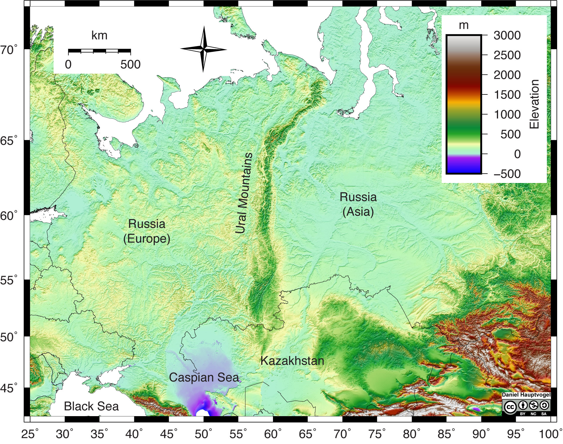
Shaded relief map of the Ural
Mountains in Russia. Red and white colors represent high elevations, greens and yellow represent lower elevation, and purple and blue represent areas below sea level. The Ural Mountains are a narrow, linear chain of mountains that trend north-south through Russia. Map
537:
250:– You must give appropriate credit, provide a link to the license, and indicate if changes were made. You may do so in any reasonable manner, but not in any way that suggests the licensor endorses you or your use.
583:
554:
Uploaded a work by Daniel
Hauptvogel and Virginia Sisson, CC BY-NC-SA from https://uhlibraries.pressbooks.pub/historicalgeologylab/ with UploadWizard
448:
412:
654:
This file contains additional information, probably added from the digital camera or scanner used to create or digitize it.
257:
358:
338:
680:
468:
396:
351:
432:
376:
322:
65:
61:
57:
53:
47:
110:
219:
78:
657:
If the file has been modified from its original state, some details may not fully reflect the modified file.
256:– If you remix, transform, or build upon the material, you must distribute your contributions under the
547:
216:
568:
118:
573:
173:
163:
578:
105:
536:
531:
69:
42:
504:
Click on a date/time to view the file as it appeared at that time.
601:
93:
449:
Creative
Commons Attribution-ShareAlike 4.0 International
641:
174:
https://uhlibraries.pressbooks.pub/historicalgeologylab/
83:(1,916 × 1,514 pixels, file size: 946 KB, MIME type:
584:
Knowledge:Graphics Lab/Map workshop/Archive/Jun 2023
137:
117:
Commons is a freely licensed media file repository.
631:
621:
611:
183:Daniel Hauptvogel and Virginia Sisson, CC BY-NC-SA
267:https://creativecommons.org/licenses/by-sa/4.0
98:
273:Creative Commons Attribution-Share Alike 4.0
197:
8:
233:– to copy, distribute and transmit the work
659:
506:
302:
294:
714:uuid:06567f9c-9b0c-244d-834b-7d9d81334138
594:The following other wikis use this file:
220:Attribution-Share Alike 4.0 International
709:
701:
693:
685:
675:
666:
661:
566:
482:
466:
446:
430:
410:
394:
374:
336:
320:
317:
290:
283:
564:The following 4 pages use this file:
7:
495:
208:
203:
681:Adobe Illustrator 24.1 (Macintosh)
652:
311:
305:
297:
194:
147:
130:
76:
310:
288:
244:Under the following conditions:
215:This file is licensed under the
207:
202:
196:
154:scale reference is 60° latitude.
97:
31:
21:
703:Date metadata was last modified
285:
148:
14:
711:Unique ID of original document
284:
26:
1:
36:
318:Items portrayed in this file
687:Date and time of digitizing
628:Usage on pl.wiktionary.org
618:Usage on lld.wikipedia.org
608:Usage on fi.wiktionary.org
598:Usage on bcl.wikipedia.org
731:
638:Usage on sq.wikipedia.org
258:same or compatible license
695:File change date and time
496:
306:Topografi Pegunungan Ural
298:Ural Mountains Topography
16:
287:
224:
104:This is a file from the
553:
179:
169:
162:
159:
140:
108:. Information from its
532:16:11, 20 October 2022
111:description page there
46:Size of this preview:
164:9 June 2020, 10:45:27
70:1,916 × 1,514 pixels
66:1,280 × 1,011 pixels
239:– to adapt the work
52:Other resolutions:
706:10:45, 9 June 2020
698:20:45, 9 June 2020
690:10:45, 9 June 2020
602:Kabukidan kan Ural
569:Pechora coal basin
718:
717:
590:Global file usage
557:
433:copyright license
304:
296:
187:
186:
143:Uraltopomap-1.jpg
126:
125:
106:Wikimedia Commons
32:Global file usage
722:
670:
660:
574:Sub-Ural Plateau
544:
397:copyright status
361:
356:
280:
277:
274:
271:
268:
260:as the original.
217:Creative Commons
211:
210:
206:
205:
200:
199:
165:
152:
144:
138:
122:
101:
100:
94:
88:
86:
73:
62:972 × 768 pixels
58:608 × 480 pixels
54:304 × 240 pixels
48:759 × 600 pixels
730:
729:
725:
724:
723:
721:
720:
719:
668:
648:
588:
558:
550:
542:
498:
497:
494:
493:
492:
491:
490:
489:
488:
487:
485:
475:
474:
473:
471:
460:
459:
458:
457:
456:
455:
454:
453:
451:
439:
438:
437:
435:
424:
423:
422:
421:
420:
419:
418:
417:
415:
403:
402:
401:
399:
388:
387:
386:
385:
384:
383:
382:
381:
379:
368:
367:
366:
365:
364:
363:
362:
357:
354:
352:topographic map
345:
344:
343:
341:
329:
328:
327:
325:
309:
308:
307:
300:
299:
282:
281:
278:
275:
272:
269:
266:
265:
223:
212:
193:
188:
155:
142:
135:
128:
127:
116:
115:
114:is shown below.
90:
84:
82:
75:
74:
51:
12:
11:
5:
728:
726:
716:
715:
712:
708:
707:
704:
700:
699:
696:
692:
691:
688:
684:
683:
678:
674:
673:
672:
671:
664:
651:
647:
646:
645:
644:
636:
635:
634:
626:
625:
624:
616:
615:
614:
606:
605:
604:
592:
591:
587:
586:
581:
579:Ural Mountains
576:
571:
562:
561:
556:
555:
552:
548:
545:
541:1,916 × 1,514
539:
534:
529:
525:
524:
521:
518:
515:
512:
509:
502:
501:
486:
483:
481:
480:
479:
478:
477:
476:
472:
467:
465:
464:
463:
462:
461:
452:
447:
445:
444:
443:
442:
441:
440:
436:
431:
429:
428:
427:
426:
425:
416:
411:
409:
408:
407:
406:
405:
404:
400:
395:
393:
392:
391:
390:
389:
380:
375:
373:
372:
371:
370:
369:
359:Ural Mountains
350:
349:
348:
347:
346:
342:
339:Ural Mountains
337:
335:
334:
333:
332:
331:
330:
326:
321:
319:
316:
315:
314:
313:
312:
301:
293:
292:
289:
286:
264:
263:
262:
261:
251:
242:
241:
240:
234:
227:You are free:
214:
213:
195:
192:
189:
185:
184:
181:
177:
176:
171:
167:
166:
161:
157:
156:
145:
136:
134:
131:
129:
124:
123:
102:
92:
91:
45:
41:
40:
39:
34:
29:
24:
19:
13:
10:
9:
6:
4:
3:
2:
727:
713:
710:
705:
702:
697:
694:
689:
686:
682:
679:
677:Software used
676:
667:
665:
662:
658:
655:
649:
643:
640:
639:
637:
633:
630:
629:
627:
623:
620:
619:
617:
613:
610:
609:
607:
603:
600:
599:
597:
596:
595:
589:
585:
582:
580:
577:
575:
572:
570:
567:
565:
559:
551:
546:
540:
538:
535:
533:
530:
527:
526:
522:
519:
516:
513:
510:
508:
507:
505:
499:
470:
450:
434:
414:
398:
378:
360:
353:
340:
324:
270:CC BY-SA 4.0
259:
255:
252:
249:
246:
245:
243:
238:
235:
232:
229:
228:
226:
225:
221:
218:
201:
190:
182:
178:
175:
172:
168:
158:
151:
146:
139:
132:
120:
113:
112:
107:
103:
96:
95:
89:
80:
79:Original file
71:
67:
63:
59:
55:
49:
44:
38:
35:
33:
30:
28:
25:
23:
20:
18:
15:
656:
653:
593:
563:
503:
500:File history
253:
247:
236:
230:
149:
119:You can help
109:
77:
22:File history
669:Uraltopomap
663:Short title
642:Malet Urale
413:copyrighted
254:share alike
248:attribution
141:Description
560:File usage
549:Glavanator
517:Dimensions
484:image/jpeg
469:media type
303:Indonesian
85:image/jpeg
27:File usage
514:Thumbnail
511:Date/Time
191:Licensing
150:English:
650:Metadata
543:(946 KB)
291:Captions
237:to remix
231:to share
222:license.
37:Metadata
528:current
523:Comment
323:depicts
295:English
133:Summary
81:
377:Russia
180:Author
170:Source
632:Oural
622:Ural
612:Ural
520:User
279:true
276:true
160:Date
17:File
355::
68:|
64:|
60:|
56:|
50:.
121:.
87:)
72:.
Text is available under the Creative Commons Attribution-ShareAlike License. Additional terms may apply.