392:
325:
275:
317:
267:
134:
339:
289:
360:
398:
110:
403:
1004:
72:
868:"}},"text\/plain":{"en":{"":"heading"}}},"{\"value\":{\"amount\":\"+0\",\"unit\":\"http:\\\/\\\/www.wikidata.org\\\/entity\\\/Q28390\"},\"type\":\"quantity\"}":{"text\/html":{"en":{"P7787":"0
804:"}},"text\/plain":{"en":{"":"heading"}}},"{\"value\":{\"amount\":\"+0\",\"unit\":\"http:\\\/\\\/www.wikidata.org\\\/entity\\\/Q28390\"},\"type\":\"quantity\"}":{"text\/html":{"en":{"P7787":"0
800:
308:
258:
83:
51:
450:– You must give appropriate credit, provide a link to the license, and indicate if changes were made. You may do so in any reasonable manner, but not in any way that suggests the licensor endorses you or your use.
1021:== {{int:filedesc}} == {{Information |description={{en|1=View along the coast towards Ligger Point from Penhale Sands}} |date=2008-04-27 |source=From |author=[http://www.geograph.org.uk/profile/229
865:
801:
1050:
1003:
998:
42:
1108:
1045:
126:
702:
666:
630:
332:
282:
752:
367:
1081:
This file contains additional information, probably added from the digital camera or scanner used to create or digitize it.
457:
565:
935:
906:
879:
842:
815:
730:
686:
614:
586:
573:
558:
773:
745:
715:
650:
531:
514:
133:
354:
1040:
413:
1084:
If the file has been modified from its original state, some details may not fully reflect the modified file.
1031:
The following pages on the
English Knowledge (XXG) use this file (pages on other projects are not listed):
456:– If you remix, transform, or build upon the material, you must distribute your contributions under the
374:
on the
Geograph website for the photographer's contact details. The copyright on this image is owned by
121:
1014:
410:
109:
872:"}},"text\/plain":{"en":{"P7787":"0 degree"}}}}": -->
808:"}},"text\/plain":{"en":{"P7787":"0 degree"}}}}": -->
91:
227:
593:
737:
722:
211:
160:
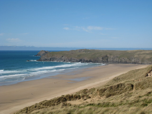
View along the coast towards Ligger Point from
Penhale Sands - geograph.org.uk - 780192.jpg
52:
View_along_the_coast_towards_Ligger_Point_from_Penhale_Sands_-_geograph.org.uk_-_780192.jpg
338:
288:
1102:
1035:
379:
78:
179:
322:
272:
200:
116:
190:
359:
371:
971:
Click on a date/time to view the file as it appeared at that time.
324:
274:
299:
249:
104:
66:
242:
View along the coast towards Ligger Point from
Penhale Sands
223:
View along the coast towards Ligger Point from
Penhale Sands
170:
View along the coast towards Ligger Point from
Penhale Sands
132:
309:
50° 22′ 10″ N, 5° 09′ 01″ W
259:
50° 21′ 44″ N, 5° 08′ 59″ W
498:
Add a one-line explanation of what this file represents
1068:
154:
90:
Commons is a freely licensed media file repository.
667:
Creative
Commons Attribution-ShareAlike 2.0 Generic
56:(640 × 480 pixels, file size: 48 KB, MIME type:
1051:Template:Did you know nominations/Penhale Sands
467:https://creativecommons.org/licenses/by-sa/2.0
71:
473:Creative Commons Attribution-Share Alike 2.0
391:
8:
1046:Knowledge (XXG):Recent additions/2012/March
869:
805:
433:– to copy, distribute and transmit the work
1086:
973:
494:
1061:The following other wikis use this file:
594:https://www.geograph.org.uk/profile/22976
115:This image appeared on Knowledge (XXG)'s
723:https://www.geograph.org.uk/photo/780192
1088:
1033:
949:
933:
893:
877:
829:
813:
787:
771:
700:
684:
664:
648:
628:
612:
545:
529:
512:
509:
490:
483:
302:
252:
331:View this and other nearby images on:
281:View this and other nearby images on:
7:
378:and is licensed for reuse under the
1109:Knowledge (XXG) Did you know images
962:
414:Attribution-Share Alike 2.0 Generic
402:
397:
382:Attribution-ShareAlike 2.0 license.
1079:
503:
497:
388:
365:
164:
147:
103:
49:
502:
816:coordinates of the point of view
488:
444:Under the following conditions:
409:This file is licensed under the
401:
396:
390:
358:
337:
323:
315:
287:
273:
265:
108:
70:
31:
21:
485:
165:
46:No higher resolution available.
14:
703:file available on the internet
484:
366:This image was taken from the
26:
1:
880:coordinates of depicted place
36:
753:Geograph Britain and Ireland
559:object of statement has role
510:Items portrayed in this file
125:column on 6 March 2012 (see
1125:
1065:Usage on www.wikidata.org
831:50°21'43.74"N, 5°8'58.56"W
458:same or compatible license
314:
264:
963:
895:50°22'10.24"N, 5°9'1.44"W
16:
1041:Restricted military area
731:geograph.org.uk image ID
487:
424:
77:This is a file from the
1020:
999:02:58, 20 February 2011
240:Rod Allday /
221:Rod Allday /
212:required by the license
196:
185:
178:
175:
157:
81:. Information from its
372:this photograph's page
343:50.369510; -5.150400
293:50.362150; -5.149600
138:
84:description page there
136:
439:– to adapt the work
574:author name string
139:
1097:
1096:
1057:Global file usage
1024:
871:
807:
651:copyright license
496:
387:
386:
370:collection. See
348:
347:
298:
297:
247:
246:
215:
143:
142:
99:
98:
79:Wikimedia Commons
32:Global file usage
1116:
1087:
1011:
917:
916:
911:
853:
852:
847:
755:
750:
740:
735:
725:
720:
716:described at URL
615:copyright status
596:
591:
581:
578:
568:
563:
480:
477:
474:
471:
468:
460:as the original.
422:
411:Creative Commons
405:
404:
400:
399:
394:
393:
380:Creative Commons
368:Geograph project
362:
355:
344:
341:
327:
326:
320:
319:
318:
312:
311:
300:
294:
291:
277:
276:
270:
269:
268:
262:
261:
250:
209:
181:
169:
161:
155:
112:
105:
95:
74:
73:
67:
61:
59:
1124:
1123:
1119:
1118:
1117:
1115:
1114:
1113:
1099:
1098:
1075:
1055:
1032:
1025:
1017:
1009:
965:
964:
961:
960:
959:
958:
957:
956:
955:
954:
952:
942:
941:
940:
938:
927:
926:
925:
924:
923:
922:
921:
920:
919:
918:
914:
912:
909:
900:
899:
898:
896:
886:
885:
884:
882:
863:
862:
861:
860:
859:
858:
857:
856:
855:
854:
850:
848:
845:
836:
835:
834:
832:
822:
821:
820:
818:
799:
798:
797:
796:
795:
794:
793:
792:
790:
780:
779:
778:
776:
765:
764:
763:
762:
761:
760:
759:
758:
757:
756:
751:
748:
742:
741:
736:
733:
727:
726:
721:
718:
709:
708:
707:
705:
693:
692:
691:
689:
678:
677:
676:
675:
674:
673:
672:
671:
669:
657:
656:
655:
653:
642:
641:
640:
639:
638:
637:
636:
635:
633:
621:
620:
619:
617:
606:
605:
604:
603:
602:
601:
600:
599:
598:
597:
592:
589:
583:
582:
579:
576:
570:
569:
564:
561:
552:
551:
550:
548:
538:
537:
536:
534:
523:
522:
521:
520:
519:
517:
501:
500:
499:
482:
481:
478:
475:
472:
469:
466:
465:
423:
420:
417:
406:
383:
353:
342:
316:
307:
306:
303:Object location
292:
266:
257:
256:
253:Camera location
248:
237:
230:
218:
191:geograph.org.uk
171:
159:
152:
145:
144:
137:Knowledge (XXG)
101:
100:
89:
88:
87:is shown below.
63:
57:
55:
48:
47:
12:
11:
5:
1122:
1120:
1112:
1111:
1101:
1100:
1095:
1094:
1091:
1078:
1074:
1073:
1072:
1071:
1059:
1058:
1054:
1053:
1048:
1043:
1038:
1030:
1029:
1028:
1023:
1022:
1019:
1015:
1012:
1006:
1001:
996:
992:
991:
988:
985:
982:
979:
976:
969:
968:
953:
950:
948:
947:
946:
945:
944:
943:
939:
934:
932:
931:
930:
929:
928:
905:
904:
903:
902:
901:
897:
894:
892:
891:
890:
889:
888:
887:
883:
878:
876:
875:
874:
873:
867:
841:
840:
839:
838:
837:
833:
830:
828:
827:
826:
825:
824:
823:
819:
814:
812:
811:
810:
809:
803:
791:
788:
786:
785:
784:
783:
782:
781:
777:
772:
770:
769:
768:
767:
766:
744:
743:
729:
728:
714:
713:
712:
711:
710:
706:
701:
699:
698:
697:
696:
695:
694:
690:
687:source of file
685:
683:
682:
681:
680:
679:
670:
665:
663:
662:
661:
660:
659:
658:
654:
649:
647:
646:
645:
644:
643:
634:
629:
627:
626:
625:
624:
623:
622:
618:
613:
611:
610:
609:
608:
607:
585:
584:
572:
571:
557:
556:
555:
554:
553:
549:
546:
544:
543:
542:
541:
540:
539:
535:
530:
528:
527:
526:
525:
524:
518:
513:
511:
508:
507:
506:
505:
504:
493:
492:
489:
486:
464:
463:
462:
461:
451:
442:
441:
440:
434:
427:You are free:
418:
408:
407:
389:
385:
384:
363:
352:
349:
346:
345:
335:
329:
304:
296:
295:
285:
279:
254:
245:
244:
238:
235:
232:
231:
226:
219:
216:
204:
203:
198:
194:
193:
187:
183:
182:
177:
173:
172:
162:
153:
151:
148:
146:
141:
140:
130:
113:
102:
97:
96:
75:
65:
64:
45:
41:
40:
39:
34:
29:
24:
19:
13:
10:
9:
6:
4:
3:
2:
1121:
1110:
1107:
1106:
1104:
1092:
1089:
1085:
1082:
1076:
1070:
1067:
1066:
1064:
1063:
1062:
1056:
1052:
1049:
1047:
1044:
1042:
1039:
1037:
1036:Penhale Sands
1034:
1026:
1018:
1013:
1007:
1005:
1002:
1000:
997:
994:
993:
989:
986:
983:
980:
977:
975:
974:
972:
966:
937:
908:
881:
844:
817:
789:27 April 2008
775:
754:
747:
739:
732:
724:
717:
704:
688:
668:
652:
632:
616:
595:
588:
575:
567:
560:
533:
516:
470:CC BY-SA 2.0
459:
455:
452:
449:
446:
445:
443:
438:
435:
432:
429:
428:
426:
425:
419:Attribution:
415:
412:
395:
381:
377:
373:
369:
364:
361:
357:
356:
350:
340:
336:
334:
333:OpenStreetMap
330:
328:
310:
305:
301:
290:
286:
284:
283:OpenStreetMap
280:
278:
260:
255:
251:
243:
239:
234:
233:
229:
225: /
224:
220:
213:
208:
206:
205:
202:
199:
195:
192:
188:
184:
180:27 April 2008
174:
168:
163:
156:
149:
135:
131:
128:
124:
123:
122:Did you know?
118:
114:
111:
107:
106:
93:
86:
85:
80:
76:
69:
68:
62:
53:
44:
38:
35:
33:
30:
28:
25:
23:
20:
18:
15:
1083:
1080:
1060:
970:
967:File history
566:photographer
453:
447:
436:
430:
375:
313:
263:
241:
228:CC BY-SA 2.0
222:
166:
120:
92:You can help
82:
50:
22:File history
1016:GeographBot
631:copyrighted
454:share alike
448:attribution
207:Attribution
158:Description
1090:_error
1027:File usage
1008:640 × 480
984:Dimensions
951:image/jpeg
936:media type
580:Rod Allday
547:some value
421:Rod Allday
376:Rod Allday
201:Rod Allday
58:image/jpeg
27:File usage
981:Thumbnail
978:Date/Time
774:inception
351:Licensing
236:InfoField
217:InfoField
167:English:
117:Main Page
1103:Category
1077:Metadata
1069:Q7162815
746:operator
491:Captions
437:to remix
431:to share
416:license.
127:archives
37:Metadata
1010:(48 KB)
995:current
990:Comment
907:heading
866:heading
843:heading
802:heading
532:creator
515:depicts
495:English
150:Summary
119:in the
54:
915:degree
870:degree
851:degree
806:degree
738:780192
321:
271:
197:Author
186:Source
189:From
987:User
479:true
476:true
176:Date
17:File
587:URL
1105::
913:0
910::
849:0
846::
749::
734::
719::
590::
577::
562::
129:).
1093:0
214:)
210:(
94:.
60:)
Text is available under the Creative Commons Attribution-ShareAlike License. Additional terms may apply.
_heading:0.00&language=en)
_heading:0.00&language=en)
