46:
284:
296:
79:
29:
86:
53:
267:
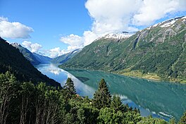
are two small fjord arms that branch off the Fjærdlandsfjorden. The fjord is about 1.5 kilometres (0.93 mi) wide, with steep mountains on both sides of the fjord. The head of the fjord is the only habitable area around the fjord. It is a flat river valley extending north of the fjord. The inner
268:
part of the fjord where the village of Fjærland is located is only accessible by boat or via long road tunnels through the surrounding mountains. The western end of the
45:
130:
78:
295:
283:
363:
312:
332:
162:
256:
248:
216:
264:
368:
176:
28:
357:
269:
255:
in
Sogndal, flowing to the south until it joins the Sognefjorden near the village of
244:
169:
252:
220:
260:
145:
132:
236:
114:
336:
163:
240:
182:
251:. The 25-kilometre (16 mi) long fjord begins at the village of
232:
212:
208:
200:
192:
188:
175:
161:
122:
110:
21:
123:
243:. It is a fjord arm that branches off the main
8:
18:
85:
52:
324:
279:
272:sits very near the shore of the fjord.
7:
301:Looking north from atop a mountain
14:
294:
282:
84:
77:
51:
44:
27:
199:
191:
247:to the north, running through
1:
204:1.5 kilometres (0.93 mi)
109:
289:Looking north from sea level
385:
196:25 kilometres (16 mi)
98:Fjærlandsfjorden (Norway)
38:
26:
313:List of Norwegian fjords
33:View from north to south
16:Fjord in Sogndal, Norway
333:Store norske leksikon
65:Location of the fjord
249:Sogndal Municipality
68:Show map of Vestland
142: /
364:Fjords of Vestland
337:"Fjærlandsfjorden"
146:61.4042°N 6.7517°E
101:Show map of Norway
226:
225:
376:
348:
347:
345:
344:
329:
298:
286:
229:Fjærlandsfjorden
165:
164:Primary outflows
157:
156:
154:
153:
152:
147:
143:
140:
139:
138:
135:
125:
102:
92:Fjærlandsfjorden
88:
87:
81:
69:
59:Fjærlandsfjorden
55:
54:
48:
31:
22:Fjærlandsfjorden
19:
384:
383:
379:
378:
377:
375:
374:
373:
354:
353:
352:
351:
342:
340:
331:
330:
326:
321:
309:
302:
299:
290:
287:
278:
179: countries
151:61.4042; 6.7517
150:
148:
144:
141:
136:
133:
131:
129:
128:
117:
106:
105:
104:
103:
100:
99:
96:
95:
94:
93:
89:
72:
71:
70:
67:
66:
63:
62:
61:
60:
56:
34:
17:
12:
11:
5:
382:
380:
372:
371:
366:
356:
355:
350:
349:
339:(in Norwegian)
323:
322:
320:
317:
316:
315:
308:
305:
304:
303:
300:
293:
291:
288:
281:
277:
274:
224:
223:
214:
210:
209:
206:
205:
202:
198:
197:
194:
190:
189:
186:
185:
180:
173:
172:
167:
159:
158:
126:
120:
119:
118:county, Norway
112:
108:
107:
97:
91:
90:
83:
82:
76:
75:
74:
73:
64:
58:
57:
50:
49:
43:
42:
41:
40:
39:
36:
35:
32:
24:
23:
15:
13:
10:
9:
6:
4:
3:
2:
381:
370:
367:
365:
362:
361:
359:
338:
334:
328:
325:
318:
314:
311:
310:
306:
297:
292:
285:
280:
275:
273:
271:
270:Frudal Tunnel
266:
262:
258:
254:
250:
246:
242:
238:
234:
230:
222:
218:
215:
211:
207:
203:
195:
187:
184:
181:
178:
174:
171:
168:
166:
160:
155:
127:
121:
116:
113:
80:
47:
37:
30:
25:
20:
341:. Retrieved
327:
265:Vetlefjorden
245:Sognefjorden
228:
227:
170:Sognefjorden
213:Settlements
193:Max. length
149: /
124:Coordinates
358:Categories
343:2014-02-09
319:References
261:Esefjorden
257:Balestrand
217:Balestrand
201:Max. width
134:61°24′15″N
137:6°45′06″E
307:See also
253:Fjærland
239:county,
237:Vestland
221:Fjærland
115:Vestland
111:Location
369:Sogndal
276:Gallery
259:. The
241:Norway
183:Norway
233:fjord
231:is a
177:Basin
263:and
235:in
360::
335:.
219:,
346:.
Text is available under the Creative Commons Attribution-ShareAlike License. Additional terms may apply.