1385:
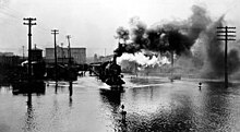
July 12, and the Kansas River rose rapidly, reaching its peak stage on July 14. Water rose 15 cm (5.9 in) an hour until within a meter (3 ft) of the top of the dike. The piers of bridges were battered by debris and whole farmhouses which had been swept downstream. Weak areas of the levee were reinforced with the help of hundreds of workers sandbagging. Shortly before midnight July 13, the Kansas River broke the levee protecting the
Argentine district, and residents were forced to flee to nearby bluffs. Early that morning, after the Armourdale district had been evacuated, a 6 km (3.7 mi) long wave of water began to cascade over the levee and inundated the district with 4.5 to 9 m (15 to 30 ft) of water. Many people were rescued by boats, out of trees, ledges and rooftops. Later that morning, the Central Industrial District was flooded even while Mayor Roe Bartle of
672:
1422:
pour into the
Fairfax District. In anticipation of such a break, a second levee had been started in order to protect the Quindaro Utility Plant in the northwest corner of the district. The plant supplied water and electricity to more than 130,000 customers in Kansas City, Kansas. Shutting down the plant would have been disastrous as water hitting the 1,100 °C (2,010 °F) boilers would lead to a devastating explosion. Workers virtually removed a nearby clay hill in their efforts to build up and support the dike. By 4 AM Saturday, the dike was within 30 cm (0.98 ft) of being topped as the flood had crested. By Monday, waters were receding as fast as they had come up.
3060:, new thunderstorm development began around 10 pm, which spread north through the city, dumping another 12 mm (0.47 in) of rain before dissipating. Around midnight on July 28, upslope flow increased behind a cold front that triggered the initial thunderstorms. Steady rains began around 1 am, ending for the most part around 4 am for much of the region except for a narrow swath including Fort Collins, where rains continued towards 7 am. However, rains renewed across the region between 8 am and noon. An additional 150–200 mm (5.9–7.9 in) of rain had fallen near Laporte. By that evening, thunderstorms redeveloped. Starting at 7 pm, heavy rains fell at
1642:
2900:
2152:– were almost completely flooded. In Marana, many homes were submerged, forcing residents to be evacuated. Over 700 homes were destroyed in Clifton. In addition, 86 of the town's 126 business were heavily damaged due to the flooding. Around 3,000 buildings were destroyed due to Octave. A total of 853 houses, mobile homes, and apartments were destroyed while 2,052 others were damaged. About 10,000 people were temporarily left homeless. Damage in Arizona totaled $ 500 million (1983
2558:. Rainfall amounts by September 10 were 200–330 mm (7.9–13.0 in) over a two-day period. Damage was unprecedented. Dam failure abounded with a total of 14 dams undermined and an addition 19 dams at risk during the event. Four major bridges failed. Thousands of acres of sugar beets, beans, potatoes, corn, and other vegetables were in ruin. A total of six people perished during the flood. Damage totaled US$ 500 million (1986 dollars), and 30 counties were declared Federal disaster areas.
3017:. During the spring thaw, this creates problems as it is usually colder in southern Canada, which makes ice jam flooding a major concern for this river basin. Starting in early February, a major flood was anticipated, over two months before the flood. This gave the region plenty of time to sandbag the nearby dikes. The river began rising on April 4, and flooding the area on April 18 as the flood waters rose up to 1.5 m (4.9 ft) above the long term prediction. Dikes gave way, and
3190:
414:
822:, was the single greatest crevasse to ever occur along the Mississippi River. It single-handedly flooded an area 80 km (50 mi) wide and 160 km (99 mi) long with up to 6 metres (20 ft) of water. Heavy spring rains caused a second major flood in the same region that June. In all, 73,500 km (28,400 sq mi) which were home to more than 931,000 people were inundated. The flood finally subsided in August. The massive
966:
3204:
2991:
1101:, the flood peaked twice within three months, first on January 14. The river stage nearly reached 21 m (69 ft). Cincinnati experienced a double disaster as 10 or more gas tanks exploded on "Black Sunday", January 24, which led to oil fires on the Ohio and in Mill Creek Valley. Two days later, the Ohio River crested in Cincinnati at a record 24.381 m (79.99 ft). flooding in the city lasted 19 days. In
2946:
341:
96:
309:
2771:. Surface dew points rose into the 50s and 60s Fahrenheit/teens Celsius, which rapidly melted the snowpack. Then, a heavy rain event occurred along a frontal zone moving in from the west, which led to 25–27 mm (0.98–1.06 in) of rainfall between January 18 and 19. Some areas lost 30–60 cm (0.98–1.97 ft) of snow in only 12 hours, which led to the bulk of the flooding.
389:
3110:
1393:
2342:
Brigantine Island, and
Absecon Island were all cut off from major travel due to flooding and were under emergency declarations. 600 people in Milford and Fairfield, Connecticut, were also evacuated. In the New York tri-state area, power outages impacted 196,700 homes, while 48,000 homes were without power in the upstate region. The
1406:
and caught in the current about a kilometer (0.5 mi) upstream from the
Hannibal Bridge. These barges threatened to destroy the remaining bridges but, fortunately, two of the barges arrived at the Hannibal Bridge at the same time and wedged against the bridge. The barges were quickly secured to the bridge with chains.
1405:
oil tanks, which went up with a roar that rocked downtown Kansas City. Soon, eight city blocks were aflame as dozens of oil tanks exploded in a chain reaction that lasted five days. The
Hannibal Bridge and A.S.B. Bridge were the only two highway bridges still operating. Several barges were torn loose
1400:
The livestock industry was paralyzed as packing plants were flooded and thousands of hogs and cattle were swept away. floodwaters made a canal out of
Southwest Boulevard. A 23,000-liter (6,000-gallon) oil tank, caught in the current, struck a high tension wire and exploded, causing additional mayhem.
262:
From
September 26 to 30 the precipitation over the greater portion of the drainage basin of the Canadian in New Mexico varied from 5 to 7 inches. This excess of monthly rainfall varied from 2.75 to about 6.5 inches in depth. The greatest precipitation in 24 consecutive hourse was about 4 inches. Such
3081:
In 1998, Tropical Storm
Charley affected the Lower Brazos River watershed. Most of the flooding occurred in the Rio Grande River basin causing 13 deaths and $ 50 million in damages. A major flood event occurred in Central Texas after 30 inches of rainfall in a few hours. The Little River experienced
2256:
for the first time since the 1960s. Due to a spillway design error at Glen Canyon coupled with the relentless flooding, the dam at Glen Canyon very nearly failed, which would have emptied Lake Powell (the second-largest man-made lake in the US) and flooded out the entire lower valley of the
Colorado
1492:
in two time periods; April 24 to 26 and May 7 until 12. The two rain events led to 75–150 mm (3.0–5.9 in) of rain falling across northern
Michigan over this three-week period. Residual snowpack in forested areas added to its effects. It was considered a once in 25–50 year event for much of
1359:
This event was the worst in Kansas since June 1903. Small rivers and creeks were running at bankfull over eastern Kansas when rainfall up to 254 mm (10.0 in) in 12 hours the last few days of June and the first few days of July caused rivers in Kansas to flood. After a break in the rainfall
2240:
for the first time since their construction except for brief tests. Releases from Hoover Dam reached a record high of 48,000 cubic feet per second (1,400 m/s) (much higher than the maximum allowed flood release of 28,000 cubic feet per second (790 m/s)), which damaged levees and riverside
2231:
in 1983 (and again in 1984). Heavy and unseasonably late snows in May were followed rapidly by warm temperatures and record rainfall in early June. The resulting huge surge of water was not forecasted and not enough water was dumped from Colorado River reservoirs in time to compensate. High inflows
1425:
The flood caused more than one billion dollars (1951 dollars) and claimed 41 lives in the Midwest. In Kansas City only three persons drowned, but property damage was $ 870 million. Of the five industrial districts only North Kansas City was completely saved. The airport and the Quindaro plants were
1421:
that Friday night. Planes were evacuated, and North Kansas City residents were ordered to leave immediately. Thousands of men, with the help of trucks and bulldozers, worked through the night to support the dike, but the collapse of the Jersey dike early July 15 was the last straw as water began to
1384:
were protected by a 10 m (33 ft) dike which was equipped with floodgates at each tributary and topped by an 2.4 m (7.9 ft) wall, which was designed to manage a flood 1.5 m (4.9 ft) higher than the June 1903 flood. The onset of floodwaters reached Kansas City, Kansas on
202:
In the early part of June the Belle Fourche and other streams on the northern slope of the Black Hills were in destructive flood attaining on June 6 a gage height of about 10.9 feet and a corresponding discharge of 5,931 second-feet. The absolute maximum gage height during this flood was 11.25 feet
2937:
and other low-lying areas forced over 120,000 people from their homes and caused over $ 2 billion in property damage alone. 48 out of California's 58 counties were declared disaster areas with many streamflow gauge stations in these areas recording return intervals of over 100 years. It would take
1957:
beginning at 6 pm and lasting to 9 pm on July 31. 200 mm (7.9 in) of rain fell in one hour, with over 300 mm (0.98 ft) falling during the event. A 5.8 m (19 ft) high fall of water swept down the canyon, taking everything in its path downstream. It was one of
1763:
was a disaster that occurred on February 26, 1972, when the Pittston Coal Company's coal slurry impoundment dam #3, located on a hillside in Logan County, West Virginia, USA, burst four days after having been declared 'satisfactory' by a federal mine inspector. Out of a population of 5,000 people,
625:
The Guadalupe and Trinity Rivers left their banks, and the Brazos River and the Colorado River joined to flood more than 3,000 square miles of land and cause the deaths of at least 177 people and massive property damage ($ 3,436,144 in the Brazos Valley alone). The flood caused the Brazos river to
108:
From February 15 to the end of March 1904 occurred the most destructive flood as far as property was concerned in the recorded history of Sacramento. The greatest known flood occurred forty-odd years before, In January, 1862 and was due to rainfall, the precipitation in December, 1861 and January,
2608:
An unusual series of storms from the Pacific Ocean starting on January 6, 1993, and continuing through January 19, 1993, caused heavy and prolonged precipitation across the State of Arizona. These heavy rains caused the most widespread and severe flooding in Arizona since the turn of the century.
2341:
from March 29 to March 30 of 1984. New York City, Atlantic City and New Jersey all declared emergencies. Many homes were flooded, roads were closed, and numerous cars were discovered underwater. 2,500 people were evacuated to safety from Monmouth and Ocean Counties in New Jersey. Atlantic City,
2300:
via underground conduits. On May 28, debris clogged the conduits, causing the creek to overflow on State Street, one of the main thoroughfares of the city. Aggressive sandbagging managed to divert the flood waters to other underground rivers via State Street, but temporary pedestrian bridges were
575:
area on the west side was inundated after a levee broke on March 25. Four thousand houses were damaged or destroyed, between 90 and 100 lives were lost, and three of four Scioto River bridges downtown were destroyed (only the Rich Street bridge survived – Town, State and Broad street bridges were
266:
The gage at the gaging station at Logan was destroyed on October 2, 1904. Mr. W. G. Russell measured the cross section and slop of bed of the Canadian as short distance below the railway bridge at Logan on October 27, 1904, and found the cross section area to be about 13,500 square feet, the mean
1215:
counties bore the brunt of the flooding. A total of 5601 homes were destroyed, and an additional 1500 homes were left uninhabitable. The three transcontinental railroads connecting Los Angeles to the outside world experienced washed out bridges and flooded lines, isolating the city. Mail service
2428:
that lasted through February 24 unleashing unprecedented amounts of rain on northern California and western Nevada. The nine-day storm over California constituted half of the average annual rainfall for the year. Record flooding occurred in three streams that drain to the southern part of the
1911:. In early April, a foot/30 cm of snow fell across the region. Intense rainfall on April 18 and 19 of 75–125 mm (3.0–4.9 in) fell over a short time frame into the residual snowpack, increasing the magnitude of the flood. The flood peaked between April 19 and 22, primarily in the
1803:
located twenty five miles upstream gave residents a false impression that they would be secure from any flooding. However, the storm waters fell almost perfectly into the Guadalupe River watershed just below the Canyon Dam. Homes were uprooted by the rushing waters and washed downstream at New
626:
change course. It now entered the Gulf of Mexico at Freeport, Texas. Major flooding brought death and destruction of greater magnitude than previously experienced. The floods of 1913 and again in 1921 were the catalyst that would cause the state of Texas to attempt to tame the Brazos River.
173:
history. The Grand River went above bankfull on the night of March 24, rising slowly for the next four days. It broke the previous high-water mark by over 60 cm (2.0 ft), and was considered a once in 100 year flood. Over one-half of the population on the west side of the river was
109:
1962 just prior to it having been 23.62 inches. This flood filled the entire flood plain, and was not limited, as was the later one, by the reclamation of large tracts of bottom land, nor was the channel below the mouth of the Feather River then filled with mining debris as it is now.
5026:
5011:
936:
in the San Francisquito Canyon above what is now the city of Santa Clarita in California failed catastrophically. At least 431 people were killed as the 47,000,000 m reservoir emptied into the Pacific Ocean near Oxnard, nearly 50 miles away. The dam and reservoir were designed by
701:
All previous records for 24-hour rainfalls were exceeded, and rivers and streams throughout the area rose past all previously recorded levels. The resulting flooding was disastrous, and approximately 80 people were killed and property damage was estimated at 25 million dollars.
3021:
was inundated. Between 75 and 90% of the residents had been evacuated prior to this time. Fires began to break out on the 19th as electric lines shorted out, which destroyed 11 buildings in downtown. The river and associated flood waters began to recede on April 23.
125:
From March 25 to 31, 1904, there occurred a flood on Mohawk River, in New York State, which, while not the largest and most destructive in the recorded history of this stream, attained a maximum discharge on March 26 of 20.84 cubic feet per second per square mile.
1747:
945:
system that conveyed water from the Owens to the city of Los Angeles. The dam's failure was attributed to design errors that did not take into account the poor foundation rock in the canyon and the resulting hydraulic uplift due to overfilling the reservoir.
2695:
saw the heaviest rain in a 24-hour period, when 536 mm (21.1 in) was recorded. The death toll was 33, with two-thirds coming from people driving into flooded areas. Thousands of homes were destroyed. Damage totaled US$ 750 million (1994 dollars).
2613:
3082:
the fifth largest discharge in its history. Flooding also occurred in the South Fork San Gabriel watershed and the Mill Creek watershed. Property damage of $ 750 million and 29 deaths were reported primarily in the Colorado and Guadalupe river basins.
2982:
went underwater, leaving only one route in and out of town. It was Ohio's worst flood in 30 years. The death toll from the event was 33, with 21 lives lost in Kentucky and 5 lost in Ohio. Hundreds were injured. Much of the devastated Kentucky city of
3064:. Between 8:30 and 10 pm, very heavy rains struck Fort Collins again. A total of over 250 mm (9.8 in) fell during this time frame, which brought storm totals to 368 mm (14.5 in) in southwest Fort Collins. The ensuing flooding of
2651:
rivers. Around 60,000 homes were damaged or destroyed. The death toll was 50 and damage totaled US$ 800 million. The result of this flood was an aggressive campaign by the federal government to buy out flooded agricultural land from willing sellers.
385:, in the Feather River basin, had 1,458 mm (57.4 in) of rain in 20 days, an event with a return period of 12,000 years. The flood episodes of 1907 and 1909 in California resulted in an overhaul of planned statewide flood control designs.
2969:
between March 1 and 3. A total of six states were impacted by the event. Record flooding was witnessed along most rivers in northern Kentucky, surpassing that of 1937. Near-record flooding was recorded in Ohio, mainly along Brush Creek and the
1194:
Two significant cyclones moved through the region; one between February 27 and March 1 and the second between March 1 and 3. Over 254 mm (10.0 in) of rain had fallen during the five-day period. Massive debris flows moved out from the
3096:
A tropical connection of moisture from Hurricane Madeline intercepted a stationary frontal zone, leading to extreme rainfall. Between October 17 and 18, rain totals of up to 559 mm (22.0 in) were recorded across central and southern
2526:
rose 15 cm (5.9 in) as a result of high inflow. The California flood resulted in 13 deaths, 50,000 people were evacuated and over $ 400 million in property damage. Three thousand residents of Linda joined in a class action lawsuit,
2212:
642:
from the rest of the state for the greater part of a month. Due to the floods 28 people died and about ten million dollars in damages were caused, with the greatest losses occurring in San Diego County, where twenty-two people died mostly in
2746:, with 250 mm (9.8 in) falling within a six-hour period. Seven lives were lost, 35,000 homes were flooded along with thousands of businesses across southeast Louisiana. Damage estimates were around US$ 1 billion (1995 dollars).
2599:
From May to September 1992 in Alaska a combination of ice jams, snow melt, and heavy rains caused the worst flooding in this area. It is said to be one of the worst disasters recorded here. Rivers reached record stages during this flood.
1454:
rivers saw near-record flows. A statewide disaster was declared, and the storm resulted in 74 deaths and $ 200 million in economic losses. The heaviest 24-hour rainfall was recorded on December 20 when 389 mm (15.3 in) fell in
853:
parishes instead. Millions of acres across seven states were flooded. Evacuees totaled 500,000. Economic losses were estimated at US$ 1 billion (1927 dollars), which was equivalent to almost one-third of the federal budget at that time.
2257:
River, cutting off water supplies to millions of people. By August as the water finally began to recede, the dam held, though only barely. Damages along the Colorado River amounted to about $ 80 million ($ 182 million in 2012 dollars).
1529:
with record-setting three-day rainfall for Lake Spaulding of 585.5 mm (23.05 in). One hundred seventy-four gage stations recorded their highest three-day rainfall totals to that time. The storm caused $ 4 million in damages.
2826:
experienced their highest levels since early November 1985, which was the flood of record for the region. A total of 33 people died during the event, with 18 from Pennsylvania and 9 from New York. It was the worst flood event for the
1316:. The heavy rain melting the existent snowpack increased runoff, and frozen ground across the region did not help matters. flooding was witnessed from April 4 to 11 and it was considered the worst flood since 1904 for the region. The
353:
In February, snowstorms had deposited a significant snowpack across the region. Then, in early March, heavy rains and warmer conditions set in, setting the stage for a flood. After the Homer Dam broke around 3 p.m. on March 7, the
3125:
through the Mid-Atlantic states during the first week of September. Only 10 days later, the combination of a stalled frontal zone, strong dynamics aloft, and a hurricane moving up the East Coast led to excessive rainfall from
2223:
conditions brought consistently above-average precipitation to the West from August 1982 until April 1983 and led to the Pacific Coast mountains, the Sierra Nevada and most of the Intermountain West receiving record snowpack.
1216:
after the flood was conducted by the U.S. Coast Guard. The death toll was 115. It was the region's worst flood since New Year's Day of 1934. The result of this flood was the flood Control Act of 1936, which authorized the
280:
A storm caused the greatest flood along the middle and lower part of the La Plata velley since 1882. It reached its maximum stage at 4pm at Pendleton, passing over the floor of the highway bridge at a depth of 2 feet.
671:
2260:
In most of north and central California, the 1982–1983 "rain year" was the wettest on record, and was the wettest since 1937–1938 in the few areas where previous records were not surpassed. Levees burst along the
2156:), which was above the preliminary estimate of $ 300 million. Fourteen people drowned and 975 persons were injured. Elsewhere, Octave was responsible for $ 12.5 million in damage in New Mexico.
3068:
caused a freight train to derail and completely destroyed two mobile home parks. Damage totaled in the hundreds of millions of dollars. Five people died. This flood event helped spawn a developing rainfall
5160:
2762:
since December 1. Significant snowpack was in place on January 18. Then, a period significant warming took place across the East, mainly during a 30-hour period, which led to ice jam floods across western
1600:
Significant snowfall preceded the event in early December. On December 18, dramatically warmer conditions coupled with nearly a 300 mm (0.98 ft) of rain led to excessive snow melt in the western
3411:
Albreacht, A., Barnes, R., Culbert, J., Dakan, D., Gerardini, P., Hawkins, S., King, K., Mengel, R., O'Boyle, C., Packard, W., Ruel, R., Shelson, B., Vanderlaan, T., DeVries, S., and Dr. Steve R. Mattox.
2845:
This was the biggest flood for the region since December 1964. Above normal rainfall had been occurring since November 1, 1995, which led to significant snowpack in the mountains by late January. Western
1848:
overflowed at 10:15 pm. Canyon Lake Dam failed at 10:45 pm, adding to the flood's magnitude. The flood crest, reached around 12:15 am, ravaged Rapid City and surrounding canyons. The death toll was 238.
2461:. One thousand-year rainfalls were recorded in the Sierras. The heaviest 24-hour rainfall ever recorded in the Central Valley at 447 mm (17.6 in) occurred on February 17 at Four Trees in the
1804:
Braunfels towards Seguin. Nighttime mass evacuations were initiated, as families scrambled to shelters in the area. Many homes and vehicles were seriously damaged and destroyed in the floodplains along
70:
destroyed or heavily damaged six large cotton mills, their associated dams, and 70 houses in the mill villages of Converse, Clifton, and Pacolet, South Carolina. Approximately 100 people were killed.
174:
inundated. On the east bank of the river, numerous factories went underwater. There was one casualty. Damages totaled US$ 1.8 million (1904 dollars). To the left is an image showing the flooding in
447:
valleys. It remains Ohio's "largest weather disaster" and Indiana's worst flood on record. Fires and tornadoes also wrought destruction. Storm-related flooding affected more than a dozen states:
439:
nearly 10 in (250 mm) of rain during a series of three winter storms led to this flood event, which affected southwest, central, and eastern Ohio, especially cities and towns along the
2850:
then experienced a 150–300 mm (5.9–11.8 in) of rainfall on February 5 to 7, which in combination with temperatures rising into the 60s Fahrenheit/upper teens Celsius led to the flood.
3044:
forced dewpoint temperatures to around 16 °C (61 °F). By 5 pm local time, thunderstorms began to erupt. Within 30 minutes, local amounts of 50 mm (2.0 in) had fallen near
3101:, which led to the flood of record in southern Texas. A total of 31 perished during the event, 17 of which were found in flooded vehicles. Damage approached US$ 750 million (1998 dollars).
2712:
exceeded its previous measured record crest by more than 1.3 m (4.3 ft), which was within 30–60 cm (0.98–1.97 ft) of the reputed crest of the legendary 1862 flood. The
2643:. Numerous rounds of showers and thunderstorms from mid-June into August led to significant flooding. Over 1,000 mm (39 in) of rainfall fell in isolated spots. Some areas of the
1304:. A pair of frontal zones brought heavy rains to the lower peninsula of Michigan during the first several days of the month. Rainfall amounts of 126 mm (5.0 in) were measured at
1816:. All the homes on Treasure Island and in Glen Cove basin were underwater. The river finally crested near 33 feet at Seguin. Fifteen persons were found to have drowned during this event.
194:
In May, very heavy rains in northern Colorado and southern Wyoming caused a flood on the Cache la Poudre and Crow Creek which resulted in the loss of considerable property along them.
1962:. Houses destroyed totaled 418. Overall damage was US$ 40 million (1976 dollars). In the aftermath of the storm, regulations were passed to limit development in similar canyons.
757:, and 93 in Williamson County. Thrall rainfall was 23.4 inches (590 mm) during 6 hours, 31.8 inches (810 mm) during 12 hours, and 36.4 inches (920 mm) during 18 hours.
5513:
4334:
2041:
on August 1 before becoming diffuse. Rainfall increased despite the lack of a surface circulation, and disastrous flooding occurred in many south Texas river basins, including the
2289:, where over 28,000 acres (11,000 ha) were inundated. As much as $ 850 million of damages were recorded in California, amounting to more than $ 1.93 billion in 2012 dollars.
435:
Significant flooding occurred between March 23 and 26 after major rivers in the central and eastern United States flooded from runoff and several days of record-breaking rain. In
2647:
were flooded for over 200 days, leading to destruction spread across nine states. This was the flood of record along many of the streams and rivers that feed the Mississippi and
750:
The 24-hour rainfall total ending 7 AM on September 10, 1921 (38.2 inches) at a U.S. Weather Bureau station in Thrall remains the national official 24-hour rainfall record.
211:
In the latter part of June and the early part of July continued heavy rain caused the rivers in southeastern Kansas to be higher than ever known before and to cause much damage.
1629:. In Oregon seventeen people died as a result of the disaster, and it caused hundreds of millions of dollars in damage. The flooding covered 152,789 acres (618.32 km). The
5986:
5234:
2704:
During the events of January and March 1995, over 100 stations recorded their greatest 1-day rainfalls in that station's history. The major brunt of the January storms hit the
4611:
3272:
1743:
rose high enough to deposit area cattle in trees. The Little River flooded tens of thousands of acres. This flood occurred after major reservoirs were built on these basins.
1714:
stalled due to high pressure in central Virginia. Within eight hours, at least 710 mm (28 in) of rain fell. This resulted in one of the worst natural disasters for
698:, during the morning of July 14, 1916, and passed to the northwest. It hit the Carolinas hard, especially western North Carolina (July 15) and northwestern South Carolina.
2117:. In Tucson, flood waters were reportedly 8 ft (2.4 m) high. Throughout the state, excessive rainfall caused many rivers to overflow. After the rain event ended, the
1558:
alone. It was by far the worst damage done to any town in the contiguous United States by a tsunami. Substantial damage and numerous deaths also occurred in the towns of
5981:
5289:
1895:. These cyclones led to 150–254 mm (5.9–10.0 in) of rain over North Carolina, with 254–483 mm (10.0–19.0 in) falling across the remainder of the
5167:
5015:
4761:"INVENTORY OF DEBRIS FLOWS AND FLOODS IN THE LOVINGSTON AND HORSESHOE MOUNTAIN, VA, 7.5' QUADRANGLES, FROM THE AUGUST 19/20, 1969, STORM IN NELSON COUNTY, VIRGINIA"
560:, 50–75 persons died after a break in the levee allowed a 7-foot-tall (2.1 m) wall of water to sweep through downtown. Five of the city's bridges washed away.
3222:
2453:
recorded 736 mm (29.0 in) of rain in 10 days, creating a once-in-a-thousand-year rainfall event. Records for 24 hour rain events were reported in the
920:
from this flood. Damages from the flood totaled US$ 40 million (in 1927 dollars). Eighty-five people lost their lives in the flood, including Vermont's Lt. Gov.
362:. By midnight, the bridges surrounding town were underwater. Six buildings in downtown Albion collapsed, which caused over US$ 125,000 in damage (1908 dollars).
4104:
406:
Heavy rains filling the Bayless reservoir cracked the concrete dam, sending an estimated 450,000,000 gallons downstream, and destroying most of the boroughs of
4930:
4899:
1672:"The 1965 flood that devastated Denver remains the most costly natural disaster in terms of property loss in state history. It also prompted the building of
4058:
3453:
2708:
basin and resulted in small stream flooding primarily due to storm drainage system failures, though flooding affected nearly every part of the state. The
5884:
5868:
5780:
1071:
Lowell had a second, lesser flood in 1938. This flood prompted the federal government to assume responsibility for flood control throughout the country.
2542:
in 2004. The California high court affirmed the District Court of Appeal's decision that said California was liable for millions of dollars in damages.
1372:, flooding inundated 70 city blocks with water up to the second floor of stores along the main commercial street. The high waters moved downstream to
58:
The greatest flood of the Kansas River on record of in the memory of the oldest inhabitants living along the stream occurred May 23 to June 13, 1903.
2511:
1340:
river basins were impacted by this inundation, which was generally considered a once in 50 year event. Damage totaled US$ 4 million (1947 dollars).
548:, as they destroyed most of the locks and many miles of embankments. The death toll from this flood was 361, with total damages of US$ 100 million.
5258:
84:
The third deadliest flash flood in US history, the normally placid Willow Creek burst its banks during an intense rain and hail storm. The city of
5192:
4734:
3217:
4523:
Connecticut River Basin, Westfield Local Protection, Westfield River Westfield, Massachusetts, Feasibility Report For Water Resources Development
1698:
history, caused by 355 mm (14.0 in) of rain in 12 hours. This caused three large dams to fail, much property damage, and loss of life.
1609:
was submerged under 3 metres (9.8 ft) of flood waters during the event. This flooding prompted flood control measures to be built along the
2929:. Similarly to the 1862 event, the flooding was a combined effect of heavy rainfall and excessive snowmelt of the relatively large early-season
880:
was where most of the death and damage was seen during this flood; local rainfall totals reached upwards of near 375 mm (14.8 in). In
263:
a downpour of rain on a basin of steep nonabsorbent surface with little or no storage resulted in a sudden and very large, though local, flood.
5320:
4003:
1979:
5806:
4252:
3957:
3821:
3595:
3065:
2045:
and its tributaries. Extensive damage occurred, and 30 people lost their lives in the flood. The maximum rainfall total in Texas occurred in
960:
3524:
5976:
5521:
4338:
4176:
5042:
795:
in February, flooding over 400 km (99,000 acres) with 3 to 5 m (9.8 to 16.4 ft) of water. The first levee break along the
1079:
1935 Republican River flood. Heavy rains on the parched lands of the Great Plains came on Memorial Day week-end, causing flooding on the
5889:
5605:
337:. Damage to the city was estimated at US$ 5 million (1907 dollars). The death toll was low, with 6–12 perishing during the inundation.
5911:
4622:
1439:
5748:
4212:
5086:
4594:
4128:
606:, Scioto River flooding carved out a 6–12 ft (1.8–3.7 m) deep channel on Hickory Street. 18 lost their lives in the city.
5836:
4087:
2278:
2219:
The year from July 1982 to June 1983 was the wettest on record both over the contiguous US as a whole and over the Western States.
683:
coast, which caused torrential rains across it and adjacent states; rains from this storm affected Southern states as far north as
5449:
4522:
2918:
2892:
1891:
and becoming a strong tropical storm. Eventually, the western nontropical low wrapped Agnes inland, which was then absorbed over
1691:
1475:
in August 1955 killed at least 87 people. The flood produced $ 8 million in damages, or over $ 100 million by today's standards.
5631:
5218:
3583:
Washed Away: How the Great Flood of 1913, America's Most Widespread Natural Disaster, Terrorized a Nation and Changed It Forever
1578:, Kalsin Bay and Kaguyak, Alaska, and Port Albini, British Columbia. Four children were swept to their deaths from a beach near
4037:
3277:
3131:
2840:
766:
556:
On the Olentangy River, this flood broke the previous record for river stage by over 14.5 ft (4.4 m). In the city of
151:
771:
From the summer of 1926 into the spring of 1927, heavy rains much greater than normal saturated the ground throughout eastern
3612:
3167:
1249:
1204:
2724:
rivers approached their record peaks. More than thirty people were killed and 5 were missing. The flood cost $ 1.8 billion.
1899:. The flood unleashed by the system was the greatest natural disaster in damages for the United States up until that time.
5293:
4822:
5924:
5902:
5657:
5360:
4476:
3267:
3262:
3171:
3163:
2660:
2046:
1944:
850:
846:
267:
velocity 11.05 feet, the maximum discharge 149,396 cubic feet per second and the maximum stage above low water 31.3 feet.
4862:
4710:
1292:. Afterwards, flood walls were erected around the city to 3 feet (0.91 m) above the highest level of the '37 flood.
4969:
4934:
3716:
3138:, and 150–300 mm (5.9–11.8 in) falling farther up the coast. It was the most damaging flood in the history of
3073:
for the United States, known as CoCoRAHS, which was anticipated to help detect ongoing flash flood events in real-time.
2878:
were severely impaired during the event. A total of 81 bridges needed to be rebuilt after the flood. A large portion of
2343:
2102:
2091:
2026:
1555:
1217:
1208:
1033:
3554:
2531:
916:, and a steel bridge replaced the old bridge to accommodate truck traffic across the river. Life was also disrupted in
3247:
3091:
2934:
2759:
2454:
2270:
2242:
1908:
1772:
Heavy rain began falling in Comal County around 8 pm on May 11. At midnight, sixteen plus inches poured upon the
1641:
1451:
1418:
1024:. In all, damage totaled US$ 113 million (1936 dollars), and 24 people were killed. Damage was significant along the
889:
863:
788:
572:
5722:
5564:"Magnitude and Frequency of the Floods of January 1997 in Northern and Central California Preliminary Determinations"
4313:
4114:
3813:
Sea Cliffs, Beaches, and Coastal Valleys of San Diego County: Some Amazing Histories and Some Horrifying Implications
3742:
1493:
the area, although many of the records set during this event stand today. Damage totaled US$ 575,000 (1960 dollars).
2388:, worse than the flooding the state witnessed in 1888. This led to debris flows and widespread damage in the Upper
2010:
area on the night of September 12, 1977. The flood caused 25 deaths and between $ 80 and $ 100 million in damages.
5416:
4680:
3395:
3135:
2807:
2755:
2717:
2709:
2438:
2405:
2401:
2338:
2196:
2118:
1845:
1800:
1402:
695:
162:, it was the worst flood in the previous 135 years of its history. Many dams were either undermined or swept away.
4903:
2346:
reported that three people died due to flooding and the area sustained hundreds of millions of dollars in damage.
590:
some 30 mi (48 km) east of Columbus to retrieve boats to rescue survivors. Flooding also occurred along
45:
events that were of significant impact to the country during the 20th century, from 1900 through 1999, inclusive.
3155:
3061:
3018:
2921:
resulted from a series of winter storms, from December 26 to January 3 of 1997, fed with tropical moisture by an
1853:
1547:
1212:
1189:
1110:
5894:
4444:
4231:
3664:
2754:
Significant snowfall during the first 20 days of January led to a snowpack across the region. Some areas of the
2570:
in Maine occurred due to four days of rain combined with melting snow and ice flows. Hardest hit areas included
675:
List of employees of the Southern Railway Company who were killed working during the 1916 flood in the Carolinas
5345:
4651:
4062:
4007:
3457:
3252:
2871:
2733:
2539:
2355:
2062:
2003:
1630:
1551:
1447:
1333:
1285:
1281:
1261:
1092:
1045:
740:
2049:, where 1,219 mm (48.0 in) of rain was deposited due to mesoscale convective systems firing along a
544:
was totally devastated, being inundated for three days in late March 1913. The floods ended operations on the
5132:
1161:
The storm of February 4–7, 1937, resulted in the highest four-day rainfall totals at several stations in the
4389:
3151:
3122:
3031:
2867:
2286:
2042:
1792:
1773:
1736:
1719:
1595:
1365:
1309:
1172:
north station had over 200 mm (7.9 in) of rain in that four days, which equaled a 450-year event.
1106:
819:
89:
3346:
2899:
4784:
4502:
4033:
3388:
3057:
2484:
2469:
2180:
1920:
1916:
1841:
1827:
1539:
1443:
1337:
1321:
1253:
1228:
784:
175:
170:
155:
135:
1887:, although it also developed a more western cyclone. The two moved in tandem, with Agnes moving offshore
289:
A tropical storm in late 1906 reported highest ever rainfalls in a southeast to northwest direction from
4672:
4582:
3257:
2908:
2879:
2875:
2859:
2672:
2450:
2381:
2361:
2337:, killing approximately 60 people in that area, and delivering high winds to Boston before flooding the
2310:
2034:
1613:. This major flood between December 18, 1964, and January 7, 1965, also impacted portions of southwest
1386:
1264:
rivers during this event. It helped spur reservoir construction on these rivers in the 1950s and 1960s.
1196:
1169:
1057:
578:
92:
in eastern Oregon, was almost completely destroyed. 220 of Heppner's 1,400 residents died in the flood.
79:
4738:
3928:
1380:, causing their worst flood up to that time. The industrial districts which border the Kansas River in
5944:
3908:
3482:
3413:
1883:
approached the cyclone, which subsequently strengthened Agnes over land back into a tropical storm in
739:, with a total of 215 fatalities. On September 9 and 10, 1921, the remnants of a hurricane moved over
17:
5324:
4676:
3686:
3209:
3004:
2684:
2519:
2458:
2365:
2318:
1876:
1435:
1289:
1277:
1114:
942:
648:
407:
382:
298:
290:
5262:
4011:
651:. Another estimate, was that fifty lives were lost in San Diego County. Among the dead was an early
5814:
5196:
4974:
4867:
4411:
4381:
3227:
3189:
3049:
3014:
2949:
2926:
2828:
2795:
2680:
2634:
2421:
2377:
2070:
1896:
1781:
1760:
1673:
1626:
1526:
1522:
1381:
1354:
1118:
1009:
635:
545:
430:
413:
163:
5118:
3511:
4586:
3532:
3134:
between September 14 and 17, with amounts of near 508 mm (20.0 in) being reported near
3053:
2984:
2688:
2644:
2617:
2567:
2499:, about 65 km (40 mi) north of Sacramento, was devastated after the levee broke on the
2274:
2253:
2164:
2141:
2110:
2007:
1950:
1856:
hosts a more comprehensive digital archive of flood-related stories, photos and news accounts on
1840:
on the morning of June 9. Heavy rainfall, with amounts of nearly 381 mm (15.0 in) near
1699:
1614:
989:
938:
905:
885:
815:
536:
5683:
4180:
2925:. It impacted Northern California, resulting in some of the most devastating flooding since the
207:
Arkansas, Kansas, Neosho, Verdigris and Osage Rivers in Southeastern Kansas – June and July 1904
5548:
5038:
4848:
3838:
3174:
counties. Of the 57 deaths attributed to Floyd, 46 were due to drowning in the flood; 35 from
410:
and Costello. A total of 78 people from Austin and 2 from Costello died during the inundation.
5955:
5862:
5774:
5535:
4590:
4556:
4248:
3953:
3947:
3889:
3817:
3801:
3591:
3237:
3045:
2979:
2975:
2922:
2815:
2779:
2692:
2664:
2504:
2496:
2488:
2430:
2425:
2293:
2126:
2087:
1928:
1888:
1872:
1711:
1506:
1468:
1361:
1305:
1200:
1134:
1122:
1037:
1021:
921:
901:
796:
652:
614:
603:
591:
440:
326:
302:
159:
4956:
4760:
4132:
3881:
3861:
3811:
3587:
3581:
1718:
in its 400 years of history. Debris flows and severe flooding claimed 150 lives, mainly from
845:
allowed engineers to create the Poydras cut, which saved the city but led to the flooding of
5609:
4809:
4696:
2912:
2799:
2787:
2768:
2705:
2473:
2442:
2262:
2133:
2106:
1975:
1971:
1924:
1610:
1563:
1377:
1180:
The storm of December 1937 was a high elevation event in the northeast corner of the state.
1150:
1080:
1065:
980:
Rain concurrent with snowmelt set the stage for this flood. It affected the entire state of
965:
893:
869:
800:
656:
639:
500:
359:
294:
5960:
5474:
2472:, nearly 254 mm (10.0 in) of rain fell in an 11-day period. System breaks in the
2245:, resulting in seven deaths. However, this was still much lower than the peak inflow above
1958:
the deadliest natural freshwater floods in U.S. history, as 143 people perished during the
1787:. The first flood waters rushed into New Braunfels from Blieders Creek and flowed into the
714:
climbed to near 19 m (62 ft) during the event. Ice blocks in the river destroyed
5928:
5906:
5755:
5588:
5499:
5046:
4433:
Ohio River flood of 1937 – Ohio History Central – A product of the Ohio Historical Society
4216:
4209:
4109:
4091:
3498:
3399:
3242:
3232:
3118:
3041:
2803:
2783:
2571:
2535:
2515:
2302:
2233:
2184:
2149:
2145:
2137:
1932:
1912:
1868:
1678:
1661:
1579:
1567:
1502:
1472:
1329:
1317:
1162:
1130:
1061:
969:
933:
897:
583:
444:
355:
322:
143:
85:
5093:
5000:
2252:
The Colorado, which is usually dry at the mouth due to extensive diversions, reached the
1633:
rated the flood as the 5th most destructive weather event in Oregon in the 20th century.
1417:
threatened to spill into the Municipal (now Downtown) Airport, the Fairfax District, and
5843:
4647:
4084:
4987:
4880:
4684:
3195:
3175:
3139:
3127:
2990:
2791:
2676:
2648:
2575:
2507:
2476:
2465:
2409:
2373:
2334:
2297:
2228:
2200:
2172:
2066:
1987:
1983:
1884:
1813:
1809:
1575:
1571:
1559:
1410:
1373:
1257:
1165:
1146:
1138:
1017:
997:
917:
827:
684:
564:
557:
504:
418:
378:
340:
95:
4432:
308:
5970:
5635:
5246:
3159:
3147:
2930:
2819:
2579:
2492:
2462:
2446:
2389:
2385:
2369:
2322:
2314:
2306:
2266:
2168:
2160:
2050:
2037:
during the night of the July 30/July 31. The circulation was followed inland west of
1991:
1796:
1777:
1653:
1645:
1606:
1602:
1456:
1325:
1245:
1029:
1013:
1005:
993:
981:
973:
913:
881:
754:
744:
492:
480:
375:
139:
67:
2945:
2364:
to the west of the area, which led to over 175 mm (6.9 in) of rain in the
2333:
A major storm on the East Coast of the United States brought tornadoes to North and
872:
moved through the region on November 3–4, dropping substantial rains across central
5916:
4154:
3010:
2971:
2823:
2764:
2721:
2551:
2380:
during the first days of November, leading to significant rainfall for the central
2192:
2114:
1954:
1837:
1746:
1740:
1518:
1414:
1369:
1142:
587:
568:
541:
512:
147:
2249:, which was recorded at 122,700 cubic feet per second (3,470 m/s) on July 1.
1025:
5697:
134:
Due mainly to the rapid melting of snow, flooding was more significant along the
5563:
5387:
4835:
4715:
4536:
4355:
4283:
3037:
2863:
2811:
2743:
2612:
2555:
2393:
2282:
2246:
2188:
2176:
2038:
1959:
1892:
1833:
1805:
1788:
1392:
873:
838:
806:
Over the next six weeks, numerous levees broke along the Mississippi River from
780:
680:
484:
456:
388:
5921:
5899:
5661:
5364:
4480:
5933:
3641:
3185:
3143:
2775:
2713:
2583:
2523:
2500:
2434:
2237:
2220:
2122:
1880:
1273:
1098:
1041:
1001:
719:
711:
644:
610:
496:
334:
330:
3893:
3720:
2094:, was flooded for 115 days. Damages totaled US$ 15.7 million (1983 dollars).
747:, dropping a storm total of 39.7 inches (1,010 mm) of rain in 36 hours.
5793:
5323:. U.S. Geological Survey (USGS), Kansas Water Science Center. Archived from
3772:
3324:
2739:
2621:
2528:
2215:
View of State Street looking north upstream during the 1983 City Creek flood
1583:
1064:
exceeded its banks, causing havoc in most of the city's northern banks. The
842:
823:
811:
715:
688:
660:
516:
472:
371:
5058:
4560:
2372:. After Juan passed by, an occluded system moved slowly northward from the
2211:
2113:. In Arizona, the highest rainfall total was 12.0 in (300 mm) at
1068:
saved the downtown area, but other sections of the city were not so lucky.
5726:
5237:. U.S. Army Corps of Engineers, New York District Website. June 26, 2024.
4317:
3746:
3109:
1935:
saw the most damage, which overall totaled US$ 50 million (1975 dollars).
5949:
5938:
3392:
2962:
2397:
2384:. Local amounts of 508 mm (20.0 in) of rain were reported from
1791:
at Landa Park. The flood waters filled the Comal and overflowed into the
1715:
1489:
1301:
1102:
1032:
floods. The flood carried off many of the bridges along the Potomac from
831:
807:
792:
776:
524:
488:
476:
468:
460:
452:
38:
34:
4464:
4232:
Environmental History of the Androscoggin River, Maine and New Hampshire
1927:
basins. The recurrence interval for this kind of flood is 50–100 years.
1764:
125 were killed, 1,121 were injured, and over 4,000 were left homeless.
198:
Belle Fourche and Red Rivers, Spearfish and Whitewood Creeks – June 1904
3070:
2668:
2640:
1543:
1313:
1126:
877:
520:
464:
448:
301:
foothills. An area of 300,000 acres (1,200 km) was flooded in the
4245:
Thirsty: William Mullholland, California Water, and the real Chinatown
4720:
3979:"Cincinnati News, Sports and Things to Do | Cincinnati Enquirer"
2847:
2018:
Flooding throughout the region caused millions of dollars in damage.
1622:
772:
647:
valley when the Lower Otay Dam failed, releasing the contents of the
5606:"The Flood of the Century – 1997 Red River Flood at Grand Forks, ND"
4796:
4795:
National Weather Service Forecast Office, Rapid City, South Dakota.
2227:
A big snowmelt in the Rocky Mountains led to record flooding on the
1546:
in March 1964, which completely devastated the downtown district of
1521:
storm brought high winds and record breaking rains. Rains fell from
333:
rivers to swell out of their banks, leading to a flood of record in
242:
Flash flood from Cloudburst, 30 feet high in canyon for 30 minutes.
4553:
Wild Water: The Story of the Far West's Great Christmas Week Floods
2503:'s south fork, forcing thousands of residents to evacuate. In the
1083:
and other rivers. It has been called "Nebraska's deadliest flood".
710:
Ice jams due to a quick thaw led to this flood. The river stage at
5698:"CoCoRaHS - Community Collaborative Rain, Hail & Snow Network"
3108:
3098:
2989:
2944:
2904:
2898:
2611:
2480:
2210:
2030:
2002:
An estimated 400 mm (16 in) of rain caused the banks of
1745:
1640:
1618:
1391:
985:
964:
909:
736:
670:
412:
387:
339:
307:
94:
42:
4412:"Nebraska Historical Markers: The Republican River Flood of 1935"
1582:, and lesser damage occurred all along the coast as far south as
1554:, resulting in 11 deaths and an economic loss of $ 14 million in
1509:
rivers. It was the third highest flood on record in these areas.
5562:
Hunrichs, Richard A.; Pratt, David A.; Meyer, Robert W. (1998).
5001:
Floods On The Lower Mississippi: An Historical Economic Overview
3178:
alone. Damage estimates were near US$ 5 billion (1999 dollars).
2966:
2305:
in succeeding years reached a record high water level, flooding
1695:
508:
436:
3909:"Chapter Eleven: The Rainmaker - And Who Caused the Big Flood?"
3393:
National Water Summary 1988–89 – Floods and Droughts: Michigan.
1875:
as a weak hurricane. Weakening into a tropical depression over
1857:
1308:
with a larger area of 75 mm (3.0 in) falling between
1284:
and caused the razing of the entire waterfront district of the
3978:
2961:
150–300 mm (5.9–11.8 in) of rain fell upon northern
2416:
Northern California and Western Nevada floods of February 1986
2153:
1784:
830:, which later catapulted him into the presidency and made the
5794:
Floods in the Guadalupe and San Antonio River Basins in Texas
3414:
New Perspectives on the 1904 Flood in Grand Rapids, Michigan.
3370:
by Christopher C. Burt, Published 2004 by WW Norton & Co.
2566:
The largest and most destructive flood in the history of the
1652:
The 1965 flood caused over five million dollars of damage in
1137:
was almost completely submerged during the flood, along with
3150:
and other rivers went over their banks, causing flooding in
5514:"Southeast Louisiana, Orleans Parish Flood Control Project"
4836:
Colorado Remembers Big Thompson Canyon Flash Flood of 1976.
3009:
The prior winter was one of the snowiest on record for the
2858:
A stationary front across the region drawing moisture from
2317:, causing a massive landslide which temporarily dammed the
321:
Snowmelt combined with heavy rains by March 16 allowed the
5500:"Lessons Taught by Floods in the United States of America"
5475:"LESSONS TAUGHT BY FLOODS IN THE UNITED STATES OF AMERICA"
5321:"Summary of Significant floods in the United States, 1986"
3456:. California Department of Water Resources. Archived from
1735:
Rainfall up to 406 mm (16.0 in) fell across the
1488:
Widespread heavy rains fell across the upper peninsula of
718:
on the river, ending the era of steamboat commerce on the
567:, suffered its worst ever flooding from the Olentangy and
312:
Image from 1907 flood in downtown Pittsburgh, Pennsylvania
4697:
http://www.uscg.mil/history/webcutters/Goldenrod_1938.pdf
2671:, Georgia. Flooding was near or at record levels for the
1710:
On the night of August 19 into August 20, the remains of
1004:
saw its mills and factories along the river damaged. The
826:
relief effort was directed by then Secretary of Commerce
253:
Las Animas, Purgatory, Arkansas Rivers Flood October 1904
2738:
A stalled front led to excessive rains across southeast
2412:
was flooded. The death toll was 50 from West Virginia.
2292:
Central Utah was heavily affected. The flooding swelled
2281:. Significant flooding also occurred on the usually dry
2053:
boundary induced by Amelia's remnant circulation aloft.
634:
During early 1916, heavy rains caused floods throughout
5235:"FACT SHEET-Passaic River Mainstem and Tributaries, NJ"
4577:
Dresbeck, Rachel (2006). "The Willamette River Flood".
4448:
2449:, recorded their worst flood to this time while nearby
679:
On July 5–6, 1916, a tropical cyclone swept across the
203:
and the corresponding discharge was 6,270 second-feet.
5259:"The State Journal – News for West Virginia's Leaders"
4579:
Oregon Disasters: True Stories of Tragedy and Survival
2742:. Rainfall up to 500 mm (20 in) fell across
2639:
Soils became saturated in the fall of 1992 across the
2360:
The antecedent event to this flood was the passage of
402:
Austin, Pennsylvania, dam failure – September 30, 1911
258:
Canadian, Cimarron and Mora River Flood – October 1904
5917:
NWS Service Assessments of Significant Weather Events
3803:
The Chicago Daily News Almanac and Year Book for 1917
3687:"Dayton: History - Town Planned Despite Flood Danger"
988:, a major flood washed out railroad tracks along the
169:
It was also considered the most destructive flood in
5723:"Flood of 1998 – Timeline of the Brazos river basin"
3743:"Flood of 1913 – Timeline of the Brazos river basin"
3620:'Our National Calamity': The Great Easter 1913 Flood
2782:
rivers experienced their highest river crests since
2368:, though less than 25 mm (0.98 in) to the
2350:
Flooding in the central Appalachians – November 1985
1450:
saw the greatest flow of record to that time, while
1008:
bridge was again destroyed. The iron bridge between
166:
saw two square miles of flooding during this event.
5388:"Water Fact Sheet: Floods in Arizona, January 1993"
4034:"Major and Catastrophic Storms and Floods in Texas"
3665:"The Superstorm That Flooded America 100 Years Ago"
3273:
United States tropical cyclone rainfall climatology
2656:
Tropical Storm Alberto floods in the Southeast 1994
2086:This was the second most severe flood in the lower
1974:occurred when the three rivers in the region – the
246:
Pinal Creek, Globe Arizona Flood – August 17, 1904
5945:Panoramic Photographs from the Library of Congress
5247:http://www.wxscape.com/FWIS/election_day_1985.html
3052:, with 50 mm (2.0 in) more falling near
2277:, and high water also threatened the dikes in the
1990:declared ten counties as disaster areas. Areas in
1986:– overflowed due to five inches of rain. Governor
1153:. Damages totaled US$ 20 million (1937 dollars).
5417:"The Arizona Floods of January and February 1993"
5029:, National Oceanic and Atmospheric Administration
4834:National Oceanic and Atmospheric Administration.
4350:
4348:
3325:"DESTRUCTIVE FLOODS IN THE UNITED STATES IN 1904"
1939:Big Thompson Canyon flood in Colorado – July 1976
1376:, forcing 20,000 persons to evacuate, then on to
743:. The center of the storm became stationary over
655:colony. San Diego residents blamed the floods on
5961:Upper Texas Coast Tropical Cyclones in the 2000s
5219:"Storm batters East with snow, wind, and floods"
3806:. Chicago Daily News Company. 1916. p. 400.
3056:before the storm weakened around 8 pm. South of
2938:months for the worst-hit areas to recover fully.
2325:(which was never rebuilt following the floods).
2309:and other areas and causing traffic problems on
2098:Tropical Storm Octave (1983) flooding in Arizona
1998:Kansas City Flash flood of 1977 – September 1977
1389:was on an aerial inspection of the flood scene.
932:Around midnight on March 12, 1928, the 195 foot
5059:"The 1983 Flooding of the Lower Colorado River"
5016:National Oceanic and Atmospheric Administration
4970:"Frankfort is hit by its worst flood since '37"
4610:Gregory, S.; L. Ashkenas; S. Jett; R. Wildman.
3952:. Sunbelt Publications, Inc. pp. 141–142.
3810:Gerald G. Kuhn; Francis Parker Shepard (1991).
3105:Hurricane Floyd floods in East – September 1999
1949:Moist easterly flow went up the terrain of the
1637:April 1965 flood of the Upper Mississippi River
613:reached a level of 69 ft (21 m) near
190:Cache la Poudre River and Crow Creek – May 1904
5027:Western NWS Region Precipitation, July to June
4931:"Flooding at the Plaza, September 12–13, 1977"
3837:Patterson, Thomas W. Freischlag, Linda (ed.).
3816:. University of California Press. p. 38.
2758:had received two to three times their average
1360:on July 4, heavy rains returned on July 5. At
1020:, the Ticonic bridge was washed downstream at
392:Damage from 1911 flood in Austin, Pennsylvania
5912:Names of Persons Killed by Big Thompson Flood
4537:http://zebu.uoregon.edu/1996/es202/flood.html
3773:"Southern California Floods of January, 1916"
3481:Library of Congress American Memory Project.
3086:Central and South Texas flood of October 1998
2750:Northeast United States flood of January 1996
2313:. The heavy rains also loosened soils in the
2232:forced opening of the emergency spillways at
1768:New Braunfels–Seguin, Texas, flood – May 1972
1676:and Dam and changed the face of the city." -
1125:, and others were disastrously inundated. In
8:
4925:
4923:
4921:
4894:
4892:
4890:
4272:. Ventura: Historical Society of California.
3013:, with 297 cm (117 in) falling at
2433:area. Extensive flooding occurred along the
2424:drifted east out of the Pacific, creating a
1590:December 1964 flood in the Pacific Northwest
1157:Santa Ana, California, flood – February 1937
735:This storm caused the most deadly floods in
5987:20th-century disasters in the United States
5900:Historic Flooding in Fort Collins, Colorado
5895:Environmental History of Androscoggin River
5658:"Historical Flooding: City of Fort Collins"
4957:Remains of Amelia – July 30 August 5, 1978.
4572:
4570:
4460:
4458:
4445:"SEMP – Evidence based disaster management"
4177:"New England Remembers November 1927 Flood"
3766:
3764:
3642:"Flooding in Indiana: Not "If", but "When""
3448:
3446:
3444:
3442:
2629:Great Flood of 1993 along Mississippi River
1820:Rapid City, South Dakota, flood – June 1972
317:Pittsburgh, Pennsylvania flood – March 1907
230:Johnstown Pennsylvania – July 8 and 9, 1904
5315:
5313:
5311:
4849:Man presumed dead since '76 found – alive.
4621:(2nd ed.). p. 28. Archived from
3440:
3438:
3436:
3434:
3432:
3430:
3428:
3426:
3424:
3422:
3223:Floods in the United States (2000–present)
3026:Fort Collins, Colorado, flood of July 1997
2550:A slow-moving storm system moved from the
2522:and the inundation of four Delta islands.
2022:Tropical Storm Amelia floods – August 1978
1664:, due to flooding and cresting of levees.
1176:Northeast California flood – December 1937
1097:A significant flood struck the region. At
62:Pacolet River (South Carolina) – June 1903
5549:"California Nevada River Forecast Center"
5386:R.D. Mac Nish; C.F. Smith; K.E. Goddard.
5284:
5282:
5280:
5012:Contiguous US Precipitation, July to June
4711:"Colorado's flood history led to changes"
4648:"Oregon's Top 10 Weather Events of 1900s"
4555:. Portland, Oregon: Overland West Press.
4004:"Significant Weather Events of the 1900s"
3384:
3382:
3380:
3378:
3376:
2700:California flood – January and March 1995
2057:Frankfort, Kentucky flood – December 1978
1832:A frontal zone was banked up against the
1750:Debris along Rapid Creek after 1972 flood
1224:Battle Creek, Michigan, flood – June 1938
912:, floods destroyed the covered bridge in
630:Southern California floods - January 1916
5982:20th-century floods in the United States
4546:
4544:
4308:
4306:
4304:
4227:
4225:
3529:The Great Flood of 1913, 100 Years Later
3477:
3475:
2987:moved to higher ground after the flood.
2933:snowpack. The resulting flooding in the
1731:Southeast Oklahoma flood – December 1971
1706:Hurricane Camille flood in Virginia 1969
814:, which inundated numerous towns in the
753:Eighty-seven people drowned in and near
5355:
5353:
3561:. Indianapolis, Indiana. March 22, 2013
3288:
3218:Floods in the United States before 1900
1113:counties were submerged. The cities of
1087:Ohio River flood of 1937 – January 1937
837:In order to avoid flooding the city of
66:On June 6, 1903, after heavy rain, the
5867:: CS1 maint: archived copy as title (
5860:
5779:: CS1 maint: archived copy as title (
5772:
5217:McFadden, Robert D. (March 30, 1984).
4785:USGS, Major floods and storms in Texas
4532:
4530:
4329:
4327:
4270:The St. Francis Dam Disaster Revisited
3973:
3971:
3969:
3782:. United States Department of Interior
3711:
3709:
3707:
3531:. Silver Jackets. 2013. Archived from
3499:Photographs from Battle Creek History.
2061:Reported as the worst flood since the
1694:flood of 1969 was one of the worst in
1220:to build a series of concrete sewers.
276:La Plata River Flood – October 6, 1904
238:Troxton Canyon Arizona – July 30, 1904
104:Sacramento River Flood – February 1904
41:, and dam failure. Below is a list of
27:List of events with significant impact
18:Floods in the United States: 1901-2000
5939:The Flood of 1951 in Northeast Kansas
4410:Gerhart, Patrick L. (June 14, 2019).
4335:"Potomac Riverkeeper – Flood History"
4204:
4202:
4200:
4198:
4129:"Vermont's Greatest Natural Disaster"
4105:"Time Collection: Mississippi Floods"
3663:Klein, Christopher (March 25, 2013).
3493:
3491:
3318:
3316:
3314:
3312:
2957:Ohio River Valley flood of March 1997
2562:Androscoggin River flood – April 1987
1702:was one of the worst-affected areas.
1060:, during the 1936 spring floods, the
961:1936 Northeastern United States flood
222:Scottdale Valley Flood – July 7, 1904
7:
5813:. September 20, 1999. Archived from
5361:"1986 Flood Victims To Get Millions"
4797:The Rapid City flood 30 Years Later.
4612:"Flood Inundations/FEMA Floodplains"
3927:Dotinga, Randy (December 31, 2008).
3555:"RetroIndy: The Great Flood of 1913"
3310:
3308:
3306:
3304:
3302:
3300:
3298:
3296:
3294:
3292:
2518:caused flooding in the community of
1844:, mainly between 6 pm and midnight.
1300:Snow fell the previous month across
928:St. Francis Dam failure - March 1928
4863:"Record floods sweep East Kentucky"
4810:Hurricane Agnes – June 14–25, 1972.
3949:San Diego: California's Cornerstone
3771:H.D. McGlashan; F.C. Ebert (1918).
3611:Trudy E. Bell (November 16, 2012).
3586:. New York: Pegasus Books. p.
3454:"Historic Rainstorms in California"
2595:May to September 1992 Alaska floods
1966:Eastern Kentucky flood – April 1977
1755:Buffalo Creek flood – February 1972
904:rivers went into flood. Along the
818:. The break at Mounds Landing near
791:rivers broke through the levees in
694:Another tropical storm passed over
5632:"Fort Collins Flood July 28, 1997"
5119:"The summer the dam almost didn't"
4709:McGhee, Tom (September 19, 2013).
4447:. December 2, 2017. Archived from
3347:"South Carolina's Deadliest Flood"
3036:On July 27, upslope flow into the
2586:industrial section was inundated.
2273:and several communities including
1668:June 14–20, 1965 flood in Colorado
1396:flooding in northeast Topeka, 1951
834:a reality within the next decade.
215:Robinson Run Flood – June 28, 1904
33:are generally caused by excessive
25:
5934:North-Central Pennsylvania Floods
5684:"Flooding || Utilities"
5536:Northeast Floods of January 1996.
3849:(4). San Diego Historical Society
3717:"Ohio River Floods – Higginsport"
3113:Flood image from just after Floyd
2125:rivers experienced their highest
1864:Hurricane Agnes flood – June 1972
1656:, alone. The US Coast Guard sent
1244:Floods of record occurred on the
858:New England flood – November 1927
586:, chartered interurban trains to
5890:Dates in Nashville USACE History
5087:"University of California Press"
4382:"The Republican River, Nebraska"
4380:Dominguez, Daizy Pineda (2018).
4284:"History in Waterville, Maine -"
3880:Lyman M. Nash (September 1960).
3862:"Torrent Floods The Otay Valley"
3843:The Journal of San Diego History
3202:
3188:
2919:1997 California New Years Floods
2893:1997 California New Years Floods
2891:This section is an excerpt from
2886:1997 California New Years Floods
2854:New England flood – October 1996
2546:Michigan floods – September 1986
1497:New Hampshire flood – April 1960
706:Ohio River flood – February 1918
271:Pecos River Flood – October 1904
99:Flooding in Battle Creek in 1904
4465:WFO SHV – Hydrology Information
4038:United States Geological Survey
3780:United States Geological Survey
3483:Selected Panoramic Photographs.
3345:McKinney, Russ (June 6, 2016).
3332:United States Geological Survey
3278:Willamette Valley flood of 1996
2841:Willamette Valley flood of 1996
2835:Willamette Valley flood of 1996
2716:set a new peak record, and the
2538:, which eventually reached the
2296:, which normally flows through
2082:Lower Mississippi flood of 1983
2033:coast and went ashore south of
1534:West Coast tsunami – March 1964
1484:Michigan flood – April/May 1960
1434:The storm affected the Central
767:Great Mississippi Flood of 1927
761:Great Mississippi Flood of 1927
417:flood image from 1913 flood at
344:flooding in Battle Creek – 1908
5430:(2). Arizona Geological Survey
5415:House, P. Kyle (Summer 1993).
4978:. December 10, 1978. p. 1
3946:Iris Wilson Engstrand (2005).
2529:Paterno v. State of California
2400:. Damage was severe where the
2321:(river), drowning the town of
2301:needed for several weeks. The
2159:Following the storm, governor
1240:Oklahoma/Arkansas flood – 1945
996:and the industrial section of
799:occurred a few miles south of
285:Sacramento Valley Flood – 1906
113:Susquehanna River – March 1904
1:
5950:The Black Hills Flood of 1972
4861:Brown, Mike (April 6, 1977).
4823:Preliminary Report for Agnes.
4735:"Flood Summaries: 06-14-1965"
4085:1927 Mississippi River flood.
3349:. South Carolina Public Radio
3268:Tropical Storm Allison (1989)
3263:Tropical Storm Alberto (1994)
3117:The antecedent conditions to
2994:Flooding in Grand Forks, 1997
1945:1976 Big Thompson River flood
1364:, at the intersection of the
1349:Great Flood of 1951 in Kansas
955:Northeast flood – spring 1936
731:Thrall flood – September 1921
659:who was hired by the city of
5885:California's Historic floods
5589:"Office of Water Prediction"
4671:Note: Surpassed only by the
4619:Willamette River Basin Atlas
4247:. Los Angeles: Vireo Books.
2978:rivers. Eastern sections of
2862:led to extreme rains across
2798:saw its highest crest since
2728:May 8, 1995, Louisiana flood
2514:, levees breaking along the
2344:U.S. Army Corps of Engineers
2279:Sacramento–San Joaquin Delta
2092:Red River Landing, Louisiana
1903:Michigan floods – April 1975
1871:moved into the coast of the
1795:, where they roared towards
1426:also spared from the worst.
1401:The burning oil ignited the
1218:U.S. Army Corps of Engineers
1034:Harpers Ferry, West Virginia
667:Southeast floods – July 1916
5977:Floods in the United States
5963:(NWS Houston/Galveston, TX)
4821:National Hurricane Center.
3907:Richard F. Pourade (1965).
3644:. Indiana Geological Survey
3248:May 8, 1995 Louisiana flood
3092:October 1998 Texas flooding
2808:South Branch of the Potomac
2604:January 1993 Arizona floods
2420:On February 11, a vigorous
2396:Basin in West Virginia and
2269:, flooding farmland in the
2243:Lower Colorado River Valley
2073:swelled after heavy rains.
1909:Lower Peninsula of Michigan
1686:July 4, 1969, flood in Ohio
1296:Michigan flood – April 1947
1028:during the greatest of all
864:Great Vermont Flood of 1927
349:Michigan flood – March 1908
31:Floods in the United States
6003:
5538:Retrieved on 2006 – 11–30.
5518:US Army Corps of Engineers
5225:. Retrieved June 28, 2024.
4959:Retrieved on 2006 – 11–30.
4851:Retrieved on 2008 – 08-04.
4838:Retrieved on 2006 – 11–30.
4825:Retrieved on 2006 – 11–30.
4812:Retrieved on 2006 – 11–30.
4799:Retrieved on 2006 – 11–30.
4681:Columbus Day Storm of 1962
4268:Nunis, Doyce, ed. (1995).
4094:Retrieved on 2006 – 11–30.
4090:November 10, 2006, at the
3929:"The Mother of All Floods"
3613:"An Epidemic of Disasters"
3512:"The Great Flood of 1908".
3485:Retrieved on 2006 – 11–30.
3398:September 6, 2006, at the
3136:Wilmington, North Carolina
3089:
3029:
3002:
2890:
2838:
2731:
2632:
2353:
2339:New York metropolitan area
1942:
1825:
1648:, during the flood of 1965
1593:
1403:Phillips Petroleum Company
1352:
1187:
1090:
958:
941:as additions to the first
861:
764:
696:Charleston, South Carolina
534:
428:
117:Due mainly to ice gorges.
88:, at the foothills of the
77:
5161:"California Water Boards"
5045:December 3, 2012, at the
4900:"KCResearch: Item Viewer"
4699:History of USCG Goldenrod
4243:Weingarten, Marc (2019).
4219:Retrieved on May 5, 2007.
3514:Retrieved on May 6, 2007.
3501:Retrieved on May 6, 2007.
3416:Retrieved on May 5, 2007.
3402:Retrieved on May 5, 2007.
3158:, among other places. In
3062:Colorado State University
2866:. Factories and mills in
2667:before stalling south of
2203:a "major disaster area".
1907:A major flood struck the
1854:Rapid City Public Library
1799:. Recent construction of
1463:New England floods – 1955
1190:Los Angeles flood of 1938
1184:Los Angeles flood of 1938
1133:was inundated. In Ohio,
594:on the city's east side.
576:destroyed). The owner of
182:Wabash River – March 1904
121:Mohawk River – March 1904
74:Heppner flood – June 1903
5927:August 11, 2006, at the
5569:. U.S. Geological Survey
5450:"Photos: Floods of 1993"
5363:. KCRA 3. Archived from
5346:Napa River flood of 1986
4652:National Weather Service
4503:"The Lost – Courant.com"
4215:August 12, 2007, at the
4008:National Weather Service
3913:San Diego History Center
3839:"Hatfield the Rainmaker"
3253:Napa River flood of 1986
3121:included the passage of
2734:May 1995 Louisiana flood
2540:California Supreme Court
2356:1985 Election day floods
2105:is considered the worst
2063:Ohio River flood of 1937
2014:New England flood – 1978
1879:, a major trough in the
1631:National Weather Service
1276:was the second-worst in
1268:Ohio River flood of 1945
1093:Ohio River flood of 1937
1016:washed away. Along the
638:, virtually cutting off
425:Great Flood – March 1913
370:The storm extended from
186:Due mainly to rainfall.
130:Grand River – March 1904
4390:Smithsonian Institution
4059:"For Immediate Release"
3580:Geoff Williams (2013).
3032:1997 Spring Creek flood
2952:during March 1997 flood
2831:as a whole since 1985.
1596:Christmas flood of 1964
1513:California flood – 1962
1430:California flood – 1955
820:Greenville, Mississippi
366:California flood – 1909
54:Kansas River – May 1903
5395:U.S. Geological Survey
4117:on September 10, 2005.
3389:U.S. Geological Survey
3114:
2995:
2953:
2915:
2806:moved by in 1955. The
2661:Tropical Storm Alberto
2625:
2329:Eastern floods of 1984
2216:
2207:Western floods of 1983
1828:1972 Black Hills flood
1751:
1649:
1540:Good Friday earthquake
1501:This flood struck the
1397:
1272:The 1945 flood of the
1229:Battle Creek, Michigan
977:
676:
421:
393:
345:
313:
150:river basins than the
100:
5534:Office of Hydrology.
5327:on September 25, 2006
5290:"1986 Flood Disaster"
4741:on September 26, 2013
4673:Heppner flood of 1903
4583:Guilford, Connecticut
4551:Lucia, Ellis (1965).
4451:on December 31, 2006.
4386:Museum on Main Street
3258:Red River flood, 1997
3123:Tropical Storm Dennis
3112:
2993:
2948:
2902:
2880:Hartford, Connecticut
2876:Lowell, Massachusetts
2663:made landfall in the
2615:
2214:
2103:Tropical Storm Octave
2027:Tropical Storm Amelia
2006:to overflow into the
1858:their 1972 flood page
1749:
1644:
1395:
1387:Kansas City, Missouri
1197:San Gabriel Mountains
1058:Lowell, Massachusetts
1052:Lowell, Massachusetts
968:
674:
579:The Columbus Dispatch
416:
391:
343:
311:
98:
80:Heppner flood of 1903
5952:(NWS Rapid City, SD)
5922:New Hampshire Floods
5905:May 5, 2006, at the
5817:on November 18, 2008
5099:on November 29, 2013
4210:NH Flood Information
3210:United States portal
3162:, the storm flooded
3005:1997 Red River flood
2999:1997 Red River flood
2534:May 1, 2009, at the
2479:included disastrous
2408:of the Potomac. The
2366:Blue Ridge Mountains
1994:were also affected.
1280:, history after the
1278:Louisville, Kentucky
1207:experienced damage,
943:Los Angeles Aqueduct
649:Lower Otay Reservoir
374:on the coast to the
5849:on October 30, 2008
5367:on October 26, 2008
5296:on October 21, 2007
4975:The Courier-Journal
4937:on October 13, 2007
4868:The Courier-Journal
4628:on December 9, 2017
4360:devinschumacher.com
4356:"reviews | DS"
4341:on October 8, 2007.
4320:on August 11, 2006.
4288:watervillemaine.net
4155:"The Flood of 1927"
3323:Murphy, EC (1905).
3228:Great Flood of 1993
3015:Fargo, North Dakota
2950:Smithland, Kentucky
2927:Great Flood of 1862
2829:Mid-Atlantic states
2796:Trenton, New Jersey
2635:Great Flood of 1993
2590:Decade of the 1990s
2422:low pressure system
2378:Mid-Atlantic States
2241:property along the
2077:Decade of the 1980s
2071:Frankfort, Kentucky
1970:Record flooding in
1897:Mid-Atlantic states
1761:Buffalo Creek flood
1726:Decade of the 1970s
1674:Chatfield Reservoir
1627:northern California
1479:Decade of the 1960s
1355:Great Flood of 1951
1344:Decade of the 1950s
1235:Decade of the 1940s
1044:suffered the worst
950:Decade of the 1930s
726:Decade of the 1920s
636:Southern California
563:The state capital,
546:Ohio and Erie Canal
431:Great Flood of 1913
397:Decade of the 1910s
49:Decade of the 1900s
5956:Teton Flood Museum
5729:on October 5, 2013
5638:on August 25, 2006
5479:www.nwrfc.noaa.gov
5454:Arizona Daily Star
5223:The New York Times
4906:on October 2, 2011
4677:1948 Vanport flood
4589:. pp. 89–96.
4208:NewHampshire.com.
3933:Voice of San Diego
3888:. pp. 25–32.
3868:. February 5, 1916
3749:on October 5, 2013
3723:on August 10, 2006
3460:on August 24, 2007
3115:
2996:
2954:
2916:
2645:Mississippi Valley
2626:
2568:Androscoggin River
2254:Gulf of California
2217:
2165:state of emergency
2111:history of Arizona
2090:Basin since 1927.
2029:skirted the lower
2008:Country Club Plaza
1951:Big Thompson River
1752:
1650:
1398:
1205:Los Angeles County
990:Androscoggin River
978:
972:, during the 1936
939:William Mulholland
906:Androscoggin River
841:, the governor of
816:Mississippi Valley
677:
621:Texas flood – 1913
537:Great Dayton Flood
422:
394:
346:
314:
101:
5199:on April 16, 2010
5140:deltarevision.com
4483:on March 14, 2006
4254:978-1-942600-02-2
4135:on April 11, 2021
4065:on March 31, 2003
3959:978-0-932653-72-7
3823:978-0-520-07433-0
3691:www.city-data.com
3597:978-1-60598-404-9
3559:Indianapolis Star
3535:on August 3, 2013
3497:Willard Library.
3238:Hurricane Camille
3130:northward up the
3077:Texas 1998 floods
2923:atmospheric river
2810:, as well as the
2693:Americus, Georgia
2665:Florida Panhandle
2505:San Joaquin River
2431:San Francisco Bay
2426:pineapple express
1889:Norfolk, Virginia
1873:Florida panhandle
1712:Hurricane Camille
1625:, and especially
1469:Connecticut River
1419:North Kansas City
1362:Manhattan, Kansas
1201:Los Angeles Basin
1038:Hancock, Maryland
1022:Waterville, Maine
922:Hollister Jackson
797:Mississippi River
741:Williamson County
653:Japanese American
441:Great Miami River
303:Sacramento Valley
16:(Redirected from
5994:
5941:(NWS Topeka, KS)
5873:
5872:
5866:
5858:
5856:
5854:
5848:
5842:. Archived from
5841:
5833:
5827:
5826:
5824:
5822:
5803:
5797:
5791:
5785:
5784:
5778:
5770:
5768:
5766:
5761:on March 3, 2016
5760:
5754:. Archived from
5753:
5745:
5739:
5738:
5736:
5734:
5725:. Archived from
5719:
5713:
5712:
5710:
5708:
5694:
5688:
5687:
5680:
5674:
5673:
5671:
5669:
5660:. Archived from
5654:
5648:
5647:
5645:
5643:
5634:. Archived from
5628:
5622:
5621:
5619:
5617:
5612:on July 14, 2006
5608:. Archived from
5602:
5596:
5595:
5593:
5585:
5579:
5578:
5576:
5574:
5568:
5559:
5553:
5552:
5545:
5539:
5532:
5526:
5525:
5524:on May 18, 2006.
5520:. Archived from
5510:
5504:
5503:
5496:
5490:
5489:
5487:
5485:
5471:
5465:
5464:
5462:
5460:
5446:
5440:
5439:
5437:
5435:
5421:
5412:
5406:
5405:
5403:
5401:
5392:
5383:
5377:
5376:
5374:
5372:
5357:
5348:
5343:
5337:
5336:
5334:
5332:
5317:
5306:
5305:
5303:
5301:
5292:. Archived from
5286:
5275:
5274:
5272:
5270:
5261:. Archived from
5255:
5249:
5244:
5238:
5232:
5226:
5215:
5209:
5208:
5206:
5204:
5195:. Archived from
5189:
5183:
5182:
5180:
5178:
5173:on March 4, 2016
5172:
5166:. Archived from
5165:
5157:
5151:
5150:
5148:
5146:
5137:
5129:
5123:
5122:
5115:
5109:
5108:
5106:
5104:
5098:
5092:. Archived from
5091:
5083:
5077:
5076:
5074:
5072:
5063:
5055:
5049:
5036:
5030:
5024:
5018:
5009:
5003:
4998:
4992:
4991:
4985:
4983:
4966:
4960:
4953:
4947:
4946:
4944:
4942:
4933:. Archived from
4927:
4916:
4915:
4913:
4911:
4902:. Archived from
4896:
4885:
4884:
4878:
4876:
4858:
4852:
4845:
4839:
4832:
4826:
4819:
4813:
4806:
4800:
4793:
4787:
4782:
4776:
4775:
4773:
4771:
4757:
4751:
4750:
4748:
4746:
4737:. Archived from
4731:
4725:
4724:
4706:
4700:
4694:
4688:
4669:
4663:
4662:
4660:
4658:
4644:
4638:
4637:
4635:
4633:
4627:
4616:
4607:
4601:
4600:
4574:
4565:
4564:
4548:
4539:
4534:
4525:
4520:
4514:
4513:
4511:
4509:
4499:
4493:
4492:
4490:
4488:
4479:. Archived from
4473:
4467:
4462:
4453:
4452:
4441:
4435:
4430:
4424:
4423:
4421:
4419:
4407:
4401:
4400:
4398:
4396:
4377:
4371:
4370:
4368:
4366:
4352:
4343:
4342:
4337:. Archived from
4331:
4322:
4321:
4316:. Archived from
4314:"NESEC – Floods"
4310:
4299:
4298:
4296:
4294:
4280:
4274:
4273:
4265:
4259:
4258:
4240:
4234:
4229:
4220:
4206:
4193:
4192:
4190:
4188:
4179:. Archived from
4173:
4167:
4166:
4164:
4162:
4157:. August 1, 2007
4151:
4145:
4144:
4142:
4140:
4131:. Archived from
4125:
4119:
4118:
4113:. Archived from
4101:
4095:
4083:Brad Edmondson.
4081:
4075:
4074:
4072:
4070:
4061:. Archived from
4055:
4049:
4048:
4046:
4044:
4030:
4024:
4023:
4021:
4019:
4010:. Archived from
4000:
3994:
3993:
3991:
3989:
3975:
3964:
3963:
3943:
3941:
3939:
3924:
3922:
3920:
3904:
3898:
3897:
3877:
3875:
3873:
3866:Mariposa Gazette
3858:
3856:
3854:
3834:
3828:
3827:
3807:
3798:
3792:
3791:
3789:
3787:
3777:
3768:
3759:
3758:
3756:
3754:
3745:. Archived from
3739:
3733:
3732:
3730:
3728:
3719:. Archived from
3713:
3702:
3701:
3699:
3697:
3683:
3677:
3676:
3674:
3672:
3660:
3654:
3653:
3651:
3649:
3640:Gustin, Andrew.
3637:
3631:
3630:
3628:
3626:
3617:
3608:
3602:
3601:
3577:
3571:
3570:
3568:
3566:
3551:
3545:
3544:
3542:
3540:
3521:
3515:
3508:
3502:
3495:
3486:
3479:
3470:
3469:
3467:
3465:
3450:
3417:
3409:
3403:
3386:
3371:
3365:
3359:
3358:
3356:
3354:
3342:
3336:
3335:
3329:
3320:
3212:
3207:
3206:
3205:
3198:
3193:
3192:
3132:Eastern Seaboard
2913:Sacramento River
2800:Hurricane Connie
2788:Hurricane Eloise
2706:Sacramento River
2474:Sacramento River
2263:Sacramento River
2201:Yavapai counties
2107:tropical cyclone
1972:eastern Kentucky
1925:Shiawassee River
1692:Independence Day
1611:Willamette River
1556:Del Norte County
1467:Flooding of the
1081:Republican River
1048:in its history.
870:tropical cyclone
801:Elaine, Arkansas
663:to create rain.
657:Charles Hatfield
640:San Diego County
21:
6002:
6001:
5997:
5996:
5995:
5993:
5992:
5991:
5967:
5966:
5929:Wayback Machine
5907:Wayback Machine
5881:
5876:
5859:
5852:
5850:
5846:
5839:
5837:"Archived copy"
5835:
5834:
5830:
5820:
5818:
5807:"Huricane 1999"
5805:
5804:
5800:
5792:
5788:
5771:
5764:
5762:
5758:
5751:
5749:"Archived copy"
5747:
5746:
5742:
5732:
5730:
5721:
5720:
5716:
5706:
5704:
5696:
5695:
5691:
5682:
5681:
5677:
5667:
5665:
5656:
5655:
5651:
5641:
5639:
5630:
5629:
5625:
5615:
5613:
5604:
5603:
5599:
5591:
5587:
5586:
5582:
5572:
5570:
5566:
5561:
5560:
5556:
5547:
5546:
5542:
5533:
5529:
5512:
5511:
5507:
5498:
5497:
5493:
5483:
5481:
5473:
5472:
5468:
5458:
5456:
5448:
5447:
5443:
5433:
5431:
5424:Arizona Geology
5419:
5414:
5413:
5409:
5399:
5397:
5390:
5385:
5384:
5380:
5370:
5368:
5359:
5358:
5351:
5344:
5340:
5330:
5328:
5319:
5318:
5309:
5299:
5297:
5288:
5287:
5278:
5268:
5266:
5257:
5256:
5252:
5245:
5241:
5233:
5229:
5216:
5212:
5202:
5200:
5191:
5190:
5186:
5176:
5174:
5170:
5163:
5159:
5158:
5154:
5144:
5142:
5135:
5131:
5130:
5126:
5121:. June 8, 2010.
5117:
5116:
5112:
5102:
5100:
5096:
5089:
5085:
5084:
5080:
5070:
5068:
5061:
5057:
5056:
5052:
5047:Wayback Machine
5037:
5033:
5025:
5021:
5010:
5006:
4999:
4995:
4981:
4979:
4968:
4967:
4963:
4955:David M. Roth.
4954:
4950:
4940:
4938:
4929:
4928:
4919:
4909:
4907:
4898:
4897:
4888:
4874:
4872:
4860:
4859:
4855:
4846:
4842:
4833:
4829:
4820:
4816:
4808:David M. Roth.
4807:
4803:
4794:
4790:
4783:
4779:
4769:
4767:
4759:
4758:
4754:
4744:
4742:
4733:
4732:
4728:
4708:
4707:
4703:
4695:
4691:
4670:
4666:
4656:
4654:
4646:
4645:
4641:
4631:
4629:
4625:
4614:
4609:
4608:
4604:
4597:
4587:Insiders' Guide
4576:
4575:
4568:
4550:
4549:
4542:
4535:
4528:
4521:
4517:
4507:
4505:
4501:
4500:
4496:
4486:
4484:
4475:
4474:
4470:
4463:
4456:
4443:
4442:
4438:
4431:
4427:
4417:
4415:
4409:
4408:
4404:
4394:
4392:
4379:
4378:
4374:
4364:
4362:
4354:
4353:
4346:
4333:
4332:
4325:
4312:
4311:
4302:
4292:
4290:
4282:
4281:
4277:
4267:
4266:
4262:
4255:
4242:
4241:
4237:
4230:
4223:
4217:Wayback Machine
4207:
4196:
4186:
4184:
4183:on June 9, 2010
4175:
4174:
4170:
4160:
4158:
4153:
4152:
4148:
4138:
4136:
4127:
4126:
4122:
4103:
4102:
4098:
4092:Wayback Machine
4082:
4078:
4068:
4066:
4057:
4056:
4052:
4042:
4040:
4032:
4031:
4027:
4017:
4015:
4014:on May 15, 2008
4002:
4001:
3997:
3987:
3985:
3977:
3976:
3967:
3960:
3945:
3944:
3937:
3935:
3926:
3925:
3918:
3916:
3906:
3905:
3901:
3879:
3878:
3871:
3869:
3860:
3859:
3852:
3850:
3836:
3835:
3831:
3824:
3809:
3808:
3800:
3799:
3795:
3785:
3783:
3775:
3770:
3769:
3762:
3752:
3750:
3741:
3740:
3736:
3726:
3724:
3715:
3714:
3705:
3695:
3693:
3685:
3684:
3680:
3670:
3668:
3662:
3661:
3657:
3647:
3645:
3639:
3638:
3634:
3624:
3622:
3615:
3610:
3609:
3605:
3598:
3579:
3578:
3574:
3564:
3562:
3553:
3552:
3548:
3538:
3536:
3523:
3522:
3518:
3509:
3505:
3496:
3489:
3480:
3473:
3463:
3461:
3452:
3451:
3420:
3410:
3406:
3400:Wayback Machine
3387:
3374:
3368:Extreme Weather
3366:
3362:
3352:
3350:
3344:
3343:
3339:
3327:
3322:
3321:
3290:
3286:
3243:Hurricane Floyd
3233:Hurricane Agnes
3208:
3203:
3201:
3194:
3187:
3184:
3119:Hurricane Floyd
3107:
3094:
3088:
3079:
3034:
3028:
3011:northern Plains
3007:
3001:
2959:
2942:
2940:
2939:
2896:
2888:
2882:was submerged.
2856:
2843:
2837:
2804:Hurricane Diane
2784:Hurricane Agnes
2752:
2736:
2730:
2702:
2658:
2637:
2631:
2606:
2597:
2592:
2564:
2548:
2536:Wayback Machine
2516:Mokelumne River
2418:
2358:
2352:
2331:
2303:Great Salt Lake
2209:
2121:, Rillito, and
2100:
2084:
2079:
2059:
2043:Guadalupe River
2024:
2016:
2000:
1968:
1947:
1941:
1905:
1869:Hurricane Agnes
1866:
1830:
1822:
1793:Guadalupe River
1776:midway between
1774:Guadalupe River
1770:
1757:
1733:
1728:
1708:
1688:
1679:The Denver Post
1670:
1662:Niota, Illinois
1639:
1598:
1592:
1580:Newport, Oregon
1536:
1515:
1499:
1486:
1481:
1473:Westfield River
1465:
1432:
1357:
1351:
1346:
1298:
1270:
1242:
1237:
1226:
1192:
1186:
1178:
1163:Santa Ana River
1159:
1105:, one-third of
1095:
1089:
1077:
1062:Merrimack River
1054:
970:Anacostia River
963:
957:
952:
934:St. Francis Dam
930:
866:
860:
769:
763:
733:
728:
708:
669:
632:
623:
600:
584:Robert F. Wolfe
554:
539:
533:
445:Olentangy River
433:
427:
404:
399:
368:
356:Kalamazoo River
351:
319:
287:
278:
273:
260:
255:
248:
240:
232:
224:
217:
209:
200:
192:
184:
132:
123:
115:
106:
82:
76:
64:
56:
51:
28:
23:
22:
15:
12:
11:
5:
6000:
5998:
5990:
5989:
5984:
5979:
5969:
5968:
5965:
5964:
5958:
5953:
5947:
5942:
5936:
5931:
5919:
5914:
5909:
5897:
5892:
5887:
5880:
5877:
5875:
5874:
5828:
5798:
5786:
5740:
5714:
5689:
5675:
5664:on May 5, 2006
5649:
5623:
5597:
5580:
5554:
5540:
5527:
5505:
5491:
5466:
5441:
5407:
5378:
5349:
5338:
5307:
5276:
5265:on May 6, 2006
5250:
5239:
5227:
5210:
5184:
5152:
5133:"Flood photos"
5124:
5110:
5078:
5050:
5031:
5019:
5004:
4993:
4988:newspapers.com
4961:
4948:
4917:
4886:
4881:newspapers.com
4853:
4840:
4827:
4814:
4801:
4788:
4777:
4752:
4726:
4701:
4689:
4685:Tillamook Burn
4664:
4639:
4602:
4595:
4566:
4540:
4526:
4515:
4494:
4468:
4454:
4436:
4425:
4402:
4372:
4344:
4323:
4300:
4275:
4260:
4253:
4235:
4221:
4194:
4168:
4146:
4120:
4096:
4076:
4050:
4025:
3995:
3965:
3958:
3915:. Copley Press
3899:
3829:
3822:
3793:
3760:
3734:
3703:
3678:
3655:
3632:
3603:
3596:
3572:
3546:
3516:
3510:Frank Passic.
3503:
3487:
3471:
3418:
3404:
3372:
3360:
3337:
3287:
3285:
3282:
3281:
3280:
3275:
3270:
3265:
3260:
3255:
3250:
3245:
3240:
3235:
3230:
3225:
3220:
3214:
3213:
3199:
3196:Weather portal
3183:
3180:
3176:North Carolina
3140:North Carolina
3128:North Carolina
3106:
3103:
3090:Main article:
3087:
3084:
3078:
3075:
3030:Main article:
3027:
3024:
3003:Main article:
3000:
2997:
2958:
2955:
2935:Central Valley
2897:
2889:
2887:
2884:
2860:Hurricane Lili
2855:
2852:
2839:Main article:
2836:
2833:
2792:Delaware River
2751:
2748:
2732:Main article:
2729:
2726:
2701:
2698:
2685:Choctawhatchee
2657:
2654:
2633:Main article:
2630:
2627:
2605:
2602:
2596:
2593:
2591:
2588:
2563:
2560:
2552:central Plains
2547:
2544:
2483:breaks in the
2455:Central Valley
2417:
2414:
2410:Paw Paw Tunnel
2374:Gulf of Mexico
2370:Mountain State
2362:Hurricane Juan
2354:Main article:
2351:
2348:
2335:South Carolina
2330:
2327:
2298:Salt Lake City
2271:Central Valley
2229:Colorado River
2208:
2205:
2099:
2096:
2083:
2080:
2078:
2075:
2067:Kentucky River
2058:
2055:
2035:Corpus Christi
2023:
2020:
2015:
2012:
1999:
1996:
1988:Julian Carroll
1967:
1964:
1943:Main article:
1940:
1937:
1904:
1901:
1885:North Carolina
1865:
1862:
1826:Main article:
1821:
1818:
1814:Lake McQueeney
1810:Geronimo Creek
1769:
1766:
1756:
1753:
1732:
1729:
1727:
1724:
1707:
1704:
1687:
1684:
1669:
1666:
1638:
1635:
1591:
1588:
1535:
1532:
1514:
1511:
1498:
1495:
1485:
1482:
1480:
1477:
1464:
1461:
1452:Central Valley
1431:
1428:
1411:Missouri River
1366:Big Blue River
1353:Main article:
1350:
1347:
1345:
1342:
1297:
1294:
1269:
1266:
1241:
1238:
1236:
1233:
1225:
1222:
1188:Main article:
1185:
1182:
1177:
1174:
1158:
1155:
1091:Main article:
1088:
1085:
1076:
1073:
1053:
1050:
1018:Kennebec River
959:Main article:
956:
953:
951:
948:
929:
926:
868:A late-season
859:
856:
828:Herbert Hoover
765:Main article:
762:
759:
732:
729:
727:
724:
707:
704:
685:North Carolina
668:
665:
631:
628:
622:
619:
599:
596:
553:
550:
535:Main article:
532:
529:
505:North Carolina
429:Main article:
426:
423:
419:Delaware, Ohio
403:
400:
398:
395:
367:
364:
350:
347:
318:
315:
286:
283:
277:
274:
272:
269:
259:
256:
254:
251:
247:
244:
239:
236:
231:
228:
223:
220:
216:
213:
208:
205:
199:
196:
191:
188:
183:
180:
131:
128:
122:
119:
114:
111:
105:
102:
90:Blue Mountains
78:Main article:
75:
72:
63:
60:
55:
52:
50:
47:
26:
24:
14:
13:
10:
9:
6:
4:
3:
2:
5999:
5988:
5985:
5983:
5980:
5978:
5975:
5974:
5972:
5962:
5959:
5957:
5954:
5951:
5948:
5946:
5943:
5940:
5937:
5935:
5932:
5930:
5926:
5923:
5920:
5918:
5915:
5913:
5910:
5908:
5904:
5901:
5898:
5896:
5893:
5891:
5888:
5886:
5883:
5882:
5879:Related links
5878:
5870:
5864:
5845:
5838:
5832:
5829:
5816:
5812:
5808:
5802:
5799:
5795:
5790:
5787:
5782:
5776:
5757:
5750:
5744:
5741:
5733:September 28,
5728:
5724:
5718:
5715:
5703:
5699:
5693:
5690:
5685:
5679:
5676:
5663:
5659:
5653:
5650:
5637:
5633:
5627:
5624:
5611:
5607:
5601:
5598:
5590:
5584:
5581:
5565:
5558:
5555:
5550:
5544:
5541:
5537:
5531:
5528:
5523:
5519:
5515:
5509:
5506:
5501:
5495:
5492:
5480:
5476:
5470:
5467:
5455:
5451:
5445:
5442:
5429:
5425:
5418:
5411:
5408:
5396:
5389:
5382:
5379:
5366:
5362:
5356:
5354:
5350:
5347:
5342:
5339:
5326:
5322:
5316:
5314:
5312:
5308:
5295:
5291:
5285:
5283:
5281:
5277:
5264:
5260:
5254:
5251:
5248:
5243:
5240:
5236:
5231:
5228:
5224:
5220:
5214:
5211:
5198:
5194:
5188:
5185:
5169:
5162:
5156:
5153:
5141:
5134:
5128:
5125:
5120:
5114:
5111:
5095:
5088:
5082:
5079:
5067:
5060:
5054:
5051:
5048:
5044:
5041:water.ca.gov
5040:
5039:Roos Flooding
5035:
5032:
5028:
5023:
5020:
5017:
5013:
5008:
5005:
5002:
4997:
4994:
4989:
4977:
4976:
4971:
4965:
4962:
4958:
4952:
4949:
4936:
4932:
4926:
4924:
4922:
4918:
4905:
4901:
4895:
4893:
4891:
4887:
4882:
4870:
4869:
4864:
4857:
4854:
4850:
4844:
4841:
4837:
4831:
4828:
4824:
4818:
4815:
4811:
4805:
4802:
4798:
4792:
4789:
4786:
4781:
4778:
4766:
4765:pubs.usgs.gov
4762:
4756:
4753:
4745:September 21,
4740:
4736:
4730:
4727:
4722:
4718:
4717:
4712:
4705:
4702:
4698:
4693:
4690:
4686:
4682:
4678:
4674:
4668:
4665:
4653:
4649:
4643:
4640:
4624:
4620:
4613:
4606:
4603:
4598:
4596:0-7627-3993-2
4592:
4588:
4584:
4580:
4573:
4571:
4567:
4562:
4558:
4554:
4547:
4545:
4541:
4538:
4533:
4531:
4527:
4524:
4519:
4516:
4504:
4498:
4495:
4482:
4478:
4472:
4469:
4466:
4461:
4459:
4455:
4450:
4446:
4440:
4437:
4434:
4429:
4426:
4414:. Corn Nation
4413:
4406:
4403:
4391:
4387:
4383:
4376:
4373:
4361:
4357:
4351:
4349:
4345:
4340:
4336:
4330:
4328:
4324:
4319:
4315:
4309:
4307:
4305:
4301:
4289:
4285:
4279:
4276:
4271:
4264:
4261:
4256:
4250:
4246:
4239:
4236:
4233:
4228:
4226:
4222:
4218:
4214:
4211:
4205:
4203:
4201:
4199:
4195:
4182:
4178:
4172:
4169:
4156:
4150:
4147:
4134:
4130:
4124:
4121:
4116:
4112:
4111:
4106:
4100:
4097:
4093:
4089:
4086:
4080:
4077:
4064:
4060:
4054:
4051:
4039:
4035:
4029:
4026:
4013:
4009:
4005:
3999:
3996:
3984:
3980:
3974:
3972:
3970:
3966:
3961:
3955:
3951:
3950:
3934:
3930:
3914:
3910:
3903:
3900:
3895:
3891:
3887:
3883:
3867:
3863:
3848:
3844:
3840:
3833:
3830:
3825:
3819:
3815:
3814:
3805:
3804:
3797:
3794:
3781:
3774:
3767:
3765:
3761:
3753:September 28,
3748:
3744:
3738:
3735:
3722:
3718:
3712:
3710:
3708:
3704:
3692:
3688:
3682:
3679:
3666:
3659:
3656:
3643:
3636:
3633:
3625:September 19,
3621:
3614:
3607:
3604:
3599:
3593:
3589:
3585:
3584:
3576:
3573:
3565:September 23,
3560:
3556:
3550:
3547:
3539:September 19,
3534:
3530:
3526:
3520:
3517:
3513:
3507:
3504:
3500:
3494:
3492:
3488:
3484:
3478:
3476:
3472:
3459:
3455:
3449:
3447:
3445:
3443:
3441:
3439:
3437:
3435:
3433:
3431:
3429:
3427:
3425:
3423:
3419:
3415:
3408:
3405:
3401:
3397:
3394:
3390:
3385:
3383:
3381:
3379:
3377:
3373:
3369:
3364:
3361:
3348:
3341:
3338:
3333:
3326:
3319:
3317:
3315:
3313:
3311:
3309:
3307:
3305:
3303:
3301:
3299:
3297:
3295:
3293:
3289:
3283:
3279:
3276:
3274:
3271:
3269:
3266:
3264:
3261:
3259:
3256:
3254:
3251:
3249:
3246:
3244:
3241:
3239:
3236:
3234:
3231:
3229:
3226:
3224:
3221:
3219:
3216:
3215:
3211:
3200:
3197:
3191:
3186:
3181:
3179:
3177:
3173:
3169:
3165:
3161:
3160:New Hampshire
3157:
3156:New Brunswick
3153:
3149:
3148:Raritan River
3145:
3141:
3137:
3133:
3129:
3124:
3120:
3111:
3104:
3102:
3100:
3093:
3085:
3083:
3076:
3074:
3072:
3067:
3063:
3059:
3055:
3051:
3047:
3043:
3039:
3033:
3025:
3023:
3020:
3016:
3012:
3006:
2998:
2992:
2988:
2986:
2981:
2977:
2973:
2968:
2965:and southern
2964:
2956:
2951:
2947:
2943:
2936:
2932:
2931:Sierra Nevada
2928:
2924:
2920:
2914:
2910:
2906:
2901:
2894:
2885:
2883:
2881:
2877:
2873:
2869:
2865:
2861:
2853:
2851:
2849:
2842:
2834:
2832:
2830:
2825:
2821:
2820:West Virginia
2817:
2813:
2809:
2805:
2801:
2797:
2793:
2789:
2785:
2781:
2777:
2772:
2770:
2766:
2761:
2760:precipitation
2757:
2749:
2747:
2745:
2741:
2735:
2727:
2725:
2723:
2719:
2715:
2711:
2710:Salinas River
2707:
2699:
2697:
2694:
2690:
2686:
2682:
2681:Chattahoochee
2678:
2674:
2670:
2666:
2662:
2655:
2653:
2650:
2646:
2642:
2636:
2628:
2623:
2619:
2614:
2610:
2603:
2601:
2594:
2589:
2587:
2585:
2581:
2577:
2573:
2569:
2561:
2559:
2557:
2553:
2545:
2543:
2541:
2537:
2533:
2530:
2525:
2521:
2517:
2513:
2509:
2506:
2502:
2498:
2494:
2493:Feather River
2490:
2486:
2482:
2478:
2475:
2471:
2467:
2464:
2463:Feather River
2460:
2459:Sierra Nevada
2456:
2452:
2448:
2447:San Francisco
2444:
2440:
2436:
2432:
2427:
2423:
2415:
2413:
2411:
2407:
2403:
2399:
2395:
2391:
2390:Potomac River
2387:
2386:West Virginia
2383:
2379:
2375:
2371:
2367:
2363:
2357:
2349:
2347:
2345:
2340:
2336:
2328:
2326:
2324:
2320:
2316:
2315:Wasatch Range
2312:
2308:
2304:
2299:
2295:
2290:
2288:
2284:
2280:
2276:
2272:
2268:
2267:Feather River
2264:
2258:
2255:
2250:
2248:
2244:
2239:
2235:
2230:
2225:
2222:
2213:
2206:
2204:
2202:
2198:
2194:
2190:
2186:
2182:
2178:
2174:
2170:
2169:Ronald Reagan
2166:
2162:
2161:Bruce Babbitt
2157:
2155:
2151:
2147:
2143:
2139:
2135:
2132:Five towns –
2130:
2128:
2124:
2120:
2116:
2112:
2108:
2104:
2097:
2095:
2093:
2089:
2081:
2076:
2074:
2072:
2068:
2064:
2056:
2054:
2052:
2048:
2044:
2040:
2036:
2032:
2028:
2021:
2019:
2013:
2011:
2009:
2005:
1997:
1995:
1993:
1992:West Virginia
1989:
1985:
1981:
1977:
1973:
1965:
1963:
1961:
1956:
1955:thunderstorms
1952:
1946:
1938:
1936:
1934:
1930:
1926:
1922:
1918:
1914:
1910:
1902:
1900:
1898:
1894:
1890:
1886:
1882:
1878:
1874:
1870:
1863:
1861:
1859:
1855:
1850:
1847:
1843:
1839:
1835:
1829:
1824:
1819:
1817:
1815:
1811:
1807:
1802:
1798:
1794:
1790:
1786:
1783:
1779:
1778:New Braunfels
1775:
1767:
1765:
1762:
1754:
1748:
1744:
1742:
1738:
1730:
1725:
1723:
1721:
1720:Nelson County
1717:
1713:
1705:
1703:
1701:
1697:
1693:
1685:
1683:
1681:
1680:
1675:
1667:
1665:
1663:
1659:
1655:
1654:Clinton, Iowa
1647:
1646:Dubuque, Iowa
1643:
1636:
1634:
1632:
1628:
1624:
1620:
1616:
1612:
1608:
1604:
1597:
1589:
1587:
1585:
1581:
1577:
1573:
1569:
1565:
1561:
1557:
1553:
1549:
1548:Crescent City
1545:
1541:
1533:
1531:
1528:
1524:
1520:
1512:
1510:
1508:
1504:
1496:
1494:
1491:
1483:
1478:
1476:
1474:
1470:
1462:
1460:
1458:
1457:Shasta County
1453:
1449:
1445:
1441:
1437:
1429:
1427:
1423:
1420:
1416:
1412:
1407:
1404:
1394:
1390:
1388:
1383:
1379:
1375:
1371:
1367:
1363:
1356:
1348:
1343:
1341:
1339:
1335:
1331:
1327:
1323:
1319:
1315:
1311:
1310:Benton Harbor
1307:
1303:
1295:
1293:
1291:
1287:
1283:
1279:
1275:
1267:
1265:
1263:
1259:
1255:
1251:
1247:
1239:
1234:
1232:
1230:
1223:
1221:
1219:
1214:
1210:
1206:
1202:
1198:
1191:
1183:
1181:
1175:
1173:
1171:
1167:
1164:
1156:
1154:
1152:
1148:
1144:
1140:
1136:
1132:
1128:
1124:
1120:
1116:
1112:
1108:
1104:
1100:
1094:
1086:
1084:
1082:
1074:
1072:
1069:
1067:
1063:
1059:
1051:
1049:
1047:
1043:
1039:
1035:
1031:
1030:Potomac River
1027:
1026:C&O Canal
1023:
1019:
1015:
1011:
1007:
1003:
999:
995:
991:
987:
983:
982:New Hampshire
975:
974:Potomac River
971:
967:
962:
954:
949:
947:
944:
940:
935:
927:
925:
923:
919:
915:
911:
907:
903:
899:
895:
891:
887:
883:
882:New Hampshire
879:
875:
871:
865:
857:
855:
852:
848:
844:
840:
835:
833:
829:
825:
821:
817:
813:
809:
804:
803:on March 29.
802:
798:
794:
790:
786:
782:
778:
774:
768:
760:
758:
756:
751:
748:
746:
742:
738:
730:
725:
723:
721:
717:
713:
705:
703:
699:
697:
692:
690:
686:
682:
673:
666:
664:
662:
658:
654:
650:
646:
641:
637:
629:
627:
620:
618:
616:
612:
607:
605:
598:Southern Ohio
597:
595:
593:
589:
585:
581:
580:
574:
570:
566:
561:
559:
552:Columbus area
551:
549:
547:
543:
538:
530:
528:
526:
522:
518:
514:
510:
506:
502:
498:
494:
493:New Hampshire
490:
486:
482:
481:Massachusetts
478:
474:
470:
466:
462:
458:
454:
450:
446:
442:
438:
432:
424:
420:
415:
411:
409:
401:
396:
390:
386:
384:
380:
377:
376:Feather River
373:
365:
363:
361:
357:
348:
342:
338:
336:
332:
328:
324:
316:
310:
306:
304:
300:
299:Sierra Nevada
296:
292:
284:
282:
275:
270:
268:
264:
257:
252:
250:
245:
243:
237:
235:
229:
227:
226:Dam Failure.
221:
219:
214:
212:
206:
204:
197:
195:
189:
187:
181:
179:
177:
172:
167:
165:
161:
157:
153:
149:
145:
141:
137:
129:
127:
120:
118:
112:
110:
103:
97:
93:
91:
87:
81:
73:
71:
69:
68:Pacolet River
61:
59:
53:
48:
46:
44:
40:
36:
32:
19:
5851:. Retrieved
5844:the original
5831:
5819:. Retrieved
5815:the original
5810:
5801:
5789:
5763:. Retrieved
5756:the original
5743:
5731:. Retrieved
5727:the original
5717:
5705:. Retrieved
5702:cocorahs.org
5701:
5692:
5678:
5666:. Retrieved
5662:the original
5652:
5640:. Retrieved
5636:the original
5626:
5614:. Retrieved
5610:the original
5600:
5583:
5571:. Retrieved
5557:
5543:
5530:
5522:the original
5517:
5508:
5494:
5482:. Retrieved
5478:
5469:
5457:. Retrieved
5453:
5444:
5432:. Retrieved
5427:
5423:
5410:
5398:. Retrieved
5394:
5381:
5369:. Retrieved
5365:the original
5341:
5329:. Retrieved
5325:the original
5298:. Retrieved
5294:the original
5267:. Retrieved
5263:the original
5253:
5242:
5230:
5222:
5213:
5201:. Retrieved
5197:the original
5187:
5175:. Retrieved
5168:the original
5155:
5143:. Retrieved
5139:
5127:
5113:
5101:. Retrieved
5094:the original
5081:
5069:. Retrieved
5065:
5053:
5034:
5022:
5007:
4996:
4986:– via
4982:December 11,
4980:. Retrieved
4973:
4964:
4951:
4941:November 27,
4939:. Retrieved
4935:the original
4908:. Retrieved
4904:the original
4879:– via
4875:December 11,
4873:. Retrieved
4866:
4856:
4843:
4830:
4817:
4804:
4791:
4780:
4768:. Retrieved
4764:
4755:
4743:. Retrieved
4739:the original
4729:
4714:
4704:
4692:
4667:
4657:December 31,
4655:. Retrieved
4642:
4632:December 31,
4630:. Retrieved
4623:the original
4618:
4605:
4578:
4552:
4518:
4506:. Retrieved
4497:
4485:. Retrieved
4481:the original
4471:
4449:the original
4439:
4428:
4416:. Retrieved
4405:
4393:. Retrieved
4385:
4375:
4363:. Retrieved
4359:
4339:the original
4318:the original
4291:. Retrieved
4287:
4278:
4269:
4263:
4244:
4238:
4185:. Retrieved
4181:the original
4171:
4159:. Retrieved
4149:
4137:. Retrieved
4133:the original
4123:
4115:the original
4108:
4099:
4079:
4067:. Retrieved
4063:the original
4053:
4041:. Retrieved
4028:
4016:. Retrieved
4012:the original
3998:
3986:. Retrieved
3983:The Enquirer
3982:
3948:
3936:. Retrieved
3932:
3917:. Retrieved
3912:
3902:
3885:
3870:. Retrieved
3865:
3851:. Retrieved
3846:
3842:
3832:
3812:
3802:
3796:
3784:. Retrieved
3779:
3751:. Retrieved
3747:the original
3737:
3725:. Retrieved
3721:the original
3694:. Retrieved
3690:
3681:
3669:. Retrieved
3658:
3646:. Retrieved
3635:
3623:. Retrieved
3619:
3606:
3582:
3575:
3563:. Retrieved
3558:
3549:
3537:. Retrieved
3533:the original
3528:
3525:"The Rivers"
3519:
3506:
3462:. Retrieved
3458:the original
3407:
3367:
3363:
3351:. Retrieved
3340:
3331:
3116:
3095:
3080:
3066:Spring Creek
3058:Fort Collins
3035:
3008:
2960:
2941:
2907:breach near
2857:
2844:
2824:Pennsylvania
2773:
2765:Pennsylvania
2753:
2737:
2703:
2689:Apalachicola
2659:
2638:
2616:Flooding in
2607:
2598:
2565:
2549:
2491:area on the
2419:
2406:North Branch
2402:South Branch
2382:Appalachians
2376:through the
2359:
2332:
2319:Spanish Fork
2291:
2283:Tulare basin
2259:
2251:
2226:
2218:
2167:. President
2158:
2131:
2115:Mount Graham
2101:
2085:
2060:
2025:
2017:
2001:
1969:
1948:
1906:
1867:
1851:
1838:South Dakota
1831:
1823:
1771:
1758:
1741:Glover River
1737:Little River
1734:
1709:
1700:Wayne County
1689:
1677:
1671:
1657:
1651:
1599:
1537:
1519:Columbus Day
1516:
1500:
1487:
1466:
1433:
1424:
1415:Kansas River
1408:
1399:
1370:Kansas River
1358:
1299:
1286:neighborhood
1271:
1243:
1227:
1193:
1179:
1160:
1096:
1078:
1075:Great Plains
1070:
1066:Francis Gate
1055:
1010:Lisbon Falls
979:
931:
886:Pemigewasset
867:
836:
805:
770:
752:
749:
734:
709:
700:
693:
678:
633:
624:
608:
601:
588:Buckeye Lake
577:
571:rivers. The
562:
555:
540:
513:Pennsylvania
434:
405:
369:
352:
320:
288:
279:
265:
261:
249:
241:
233:
225:
218:
210:
201:
193:
185:
176:Battle Creek
171:Grand Rapids
168:
148:River Raisin
133:
124:
116:
107:
83:
65:
57:
37:, excessive
30:
29:
5821:October 29,
5371:October 22,
5331:October 22,
5300:October 22,
5203:January 30,
5177:January 30,
5103:January 30,
4910:February 7,
4871:. p. 1
4716:Denver Post
4418:December 1,
4395:December 1,
4161:February 4,
4139:February 4,
3882:"Wet Reign"
3588:viii and xi
3464:October 23,
3152:Bound Brook
3038:Front Range
3019:Grand Forks
2980:Higginsport
2976:Great Miami
2864:New England
2816:Monongahela
2780:Susquehanna
2744:New Orleans
2556:Great Lakes
2457:and in the
2445:, north of
2394:Cheat River
2287:Bakersfield
2247:Lake Powell
2238:Hoover Dams
2234:Glen Canyon
2163:declared a
2129:on record.
2088:Mississippi
2039:San Antonio
2004:Brush Creek
1960:flash flood
1893:Connecticut
1846:Rapid Creek
1834:Black Hills
1806:Lake Dunlap
1789:Comal River
1782:Canyon Lake
1739:basin. The
1605:. Downtown
1552:North Coast
1507:Piscataquog
1448:North Coast
1442:areas. The
1382:Kansas City
1338:River Rouge
1282:one in 1937
1203:. Although
1135:Higginsport
1006:East Turner
902:Connecticut
874:New England
851:Plaquemines
847:St. Bernard
839:New Orleans
781:Ohio Valley
681:Mississippi
615:Higginsport
604:Chillicothe
573:Franklinton
531:Dayton area
485:Mississippi
457:Connecticut
327:Monongahela
234:Cloudburst
158:basins. In
156:Huron River
5971:Categories
5573:August 19,
4683:, and the
3886:Boys' Life
3284:References
3144:New Jersey
2818:rivers in
2714:Napa River
2524:Lake Tahoe
2501:Yuba River
2485:Olivehurst
2470:Sacramento
2404:joins the
2392:basin and
2294:City Creek
2197:Santa Cruz
2119:Santa Cruz
1976:Cumberland
1953:, forming
1881:Westerlies
1801:Canyon Dam
1615:Washington
1594:See also:
1274:Ohio River
1151:Middletown
1115:Louisville
1099:Cincinnati
1042:Pittsburgh
894:Ammonoosuc
862:See also:
789:Little Red
779:, and the
720:Ohio River
716:steamboats
712:Cincinnati
645:Otay River
611:Ohio River
592:Alum Creek
497:New Jersey
335:Pittsburgh
152:St. Joseph
5811:USA Today
4187:August 6,
4069:April 18,
4043:March 22,
4018:March 22,
3938:April 30,
3919:April 30,
3894:0006-8608
3872:April 30,
3853:April 30,
3786:April 30,
3727:August 7,
3667:. History
3050:Livermore
2909:Rio Vista
2872:Haverhill
2756:Northeast
2740:Louisiana
2622:Minnesota
2554:into the
2451:Calistoga
2285:north of
2171:declared
2142:Winkelman
1980:Big Sandy
1913:Kalamazoo
1658:Goldenrod
1584:San Diego
1542:caused a
1503:Merrimack
1444:Eel River
1440:South Bay
1330:St. Clair
1318:Kalamazoo
1209:Riverside
1199:into the
1170:Riverside
1119:Owensboro
898:Merrimack
843:Louisiana
824:Red Cross
812:Louisiana
689:Tennessee
661:San Diego
517:Tennessee
473:Louisiana
372:Fort Ross
323:Allegheny
164:Kalamazoo
144:Kalamazoo
5925:Archived
5903:Archived
5863:cite web
5853:July 15,
5796:usgs.gov
5775:cite web
5765:July 15,
5668:July 16,
5642:July 16,
5616:July 18,
5269:July 20,
5193:"Floods"
5043:Archived
4487:July 20,
4477:"Floods"
4213:Archived
4088:Archived
3396:Archived
3182:See also
3168:Cheshire
3054:Loveland
2985:Falmouth
2963:Kentucky
2868:Lawrence
2769:New York
2691:rivers.
2677:Ocmulgee
2649:Missouri
2572:Lewiston
2532:Archived
2520:Thornton
2510:and the
2441:rivers.
2398:Virginia
2185:Greenlee
1984:Kentucky
1842:Keystone
1780:and the
1716:Virginia
1603:Cascades
1564:Whittier
1490:Michigan
1413:and the
1378:Lawrence
1302:Michigan
1290:Portland
1258:Ouachita
1147:Hamilton
1139:Columbus
1111:Campbell
1103:Kentucky
992:east of
832:New Deal
808:Illinois
793:Arkansas
777:Oklahoma
565:Columbus
558:Delaware
525:Virginia
501:New York
489:Missouri
477:Maryland
469:Kentucky
461:Illinois
453:Arkansas
358:flooded
291:Monterey
39:snowmelt
35:rainfall
5707:July 7,
5484:July 7,
5459:May 11,
5434:May 11,
5400:May 11,
5145:July 7,
5071:July 7,
5066:gao.gov
4770:July 7,
4561:2475714
4508:July 7,
4365:July 7,
4293:July 7,
3988:July 7,
3696:July 7,
3671:July 3,
3648:July 3,
3353:May 29,
3172:Grafton
3164:Belknap
3071:mesonet
3046:Laporte
3042:Rockies
3040:of the
2911:on the
2718:Russian
2669:Atlanta
2641:Midwest
2618:Wabasha
2576:Rumford
2439:Russian
2323:Thistle
2307:Saltair
2221:El Niño
2173:Cochise
2134:Clifton
2109:in the
2051:frontal
1929:Lansing
1877:Georgia
1568:Chenega
1550:on the
1544:tsunami
1527:Alturas
1523:Oakland
1446:on the
1334:Clinton
1326:Saginaw
1314:Detroit
1306:Jackson
1246:Sulphur
1127:Indiana
1123:Paducah
998:Rumford
918:Rumford
878:Vermont
521:Vermont
465:Indiana
449:Alabama
383:LaPorte
297:in the
160:Lansing
140:Saginaw
86:Heppner
4721:Denver
4679:, the
4675:, the
4593:
4559:
4251:
3956:
3892:
3820:
3616:(blog)
3594:
3170:, and
3146:, the
2972:Scioto
2874:, and
2848:Oregon
2790:. The
2722:Pajaro
2687:, and
2624:, 1993
2580:Mexico
2578:, and
2275:Tehama
2181:Graham
2150:Marana
2148:, and
2146:Hayden
2138:Duncan
2127:crests
2065:, the
2047:Medina
1923:, and
1812:, and
1797:Seguin
1623:Nevada
1576:Kodiak
1572:Seward
1560:Valdez
1436:Sierra
1374:Topeka
1336:, and
1262:Little
1260:, and
1250:Sabine
1231:flood
1213:Orange
1168:. The
1149:, and
1143:Dayton
1131:Aurora
1107:Kenton
1046:floods
1014:Durham
994:Bethel
976:flood.
914:Bethel
884:, the
783:. The
773:Kansas
755:Taylor
745:Thrall
569:Scioto
542:Dayton
523:, and
408:Austin
360:Albion
329:, and
146:, and
5847:(PDF)
5840:(PDF)
5759:(PDF)
5752:(PDF)
5592:(PDF)
5567:(PDF)
5420:(PDF)
5391:(PDF)
5171:(PDF)
5164:(PDF)
5136:(PDF)
5097:(PDF)
5090:(PDF)
5062:(PDF)
4847:CNN.
4626:(PDF)
4615:(PDF)
3776:(PDF)
3328:(PDF)
3142:. In
3099:Texas
2905:levee
2812:Cheat
2673:Flint
2584:Jay's
2512:Delta
2508:basin
2497:Linda
2489:Linda
2481:levee
2477:basin
2468:. In
2466:basin
2193:Pinal
2069:near
2031:Texas
1933:Flint
1921:Flint
1917:Grand
1619:Idaho
1607:Salem
1322:Grand
1166:basin
986:Maine
984:. In
910:Maine
890:Baker
785:White
737:Texas
379:basin
136:Grand
43:flood
5869:link
5855:2006
5823:2017
5781:link
5767:2006
5735:2013
5709:2023
5670:2006
5644:2006
5618:2006
5575:2024
5486:2023
5461:2020
5436:2020
5402:2020
5373:2007
5333:2007
5302:2007
5271:2006
5205:2014
5179:2014
5147:2023
5105:2014
5073:2023
4984:2023
4943:2007
4912:2022
4877:2023
4772:2023
4747:2013
4659:2010
4634:2010
4591:ISBN
4557:OCLC
4510:2023
4489:2006
4420:2021
4397:2021
4367:2023
4295:2023
4249:ISBN
4189:2006
4163:2013
4141:2013
4110:Time
4071:2018
4045:2009
4020:2009
3990:2023
3954:ISBN
3940:2015
3921:2015
3890:ISSN
3874:2015
3855:2015
3818:ISBN
3788:2015
3755:2013
3729:2006
3698:2023
3673:2013
3650:2013
3627:2013
3592:ISBN
3567:2013
3541:2013
3466:2007
3355:2018
3154:and
3048:and
2974:and
2967:Ohio
2917:The
2822:and
2814:and
2802:and
2786:and
2778:and
2776:Ohio
2774:The
2767:and
2720:and
2487:and
2443:Napa
2437:and
2435:Napa
2311:I-80
2265:and
2236:and
2199:and
2189:Pima
2177:Gila
2123:Gila
1982:and
1931:and
1852:The
1759:The
1696:Ohio
1690:The
1538:The
1517:The
1505:and
1471:and
1438:and
1409:The
1368:and
1312:and
1211:and
1109:and
1012:and
900:and
849:and
787:and
687:and
609:The
509:Ohio
443:and
437:Ohio
331:Ohio
295:Ione
154:and
2794:at
2154:USD
1836:of
1785:Dam
1660:to
1525:to
1288:of
1254:Red
1121:,
1117:,
1056:In
1036:to
1002:Jay
908:in
810:to
602:In
293:to
5973::
5865:}}
5861:{{
5809:.
5777:}}
5773:{{
5700:.
5516:.
5477:.
5452:.
5428:23
5426:.
5422:.
5393:.
5352:^
5310:^
5279:^
5221:.
5138:.
5064:.
5014:;
4972:.
4920:^
4889:^
4865:.
4763:.
4719:.
4713:.
4650:.
4617:.
4585::
4581:.
4569:^
4543:^
4529:^
4457:^
4388:.
4384:.
4358:.
4347:^
4326:^
4303:^
4286:.
4224:^
4197:^
4107:.
4036:.
4006:.
3981:.
3968:^
3931:.
3911:.
3884:.
3864:.
3847:16
3845:.
3841:.
3778:.
3763:^
3706:^
3689:.
3618:.
3590:.
3557:.
3527:.
3490:^
3474:^
3421:^
3391:.
3375:^
3330:.
3291:^
3166:,
2903:A
2870:,
2683:,
2679:,
2675:,
2620:,
2582:.
2574:,
2495:.
2195:,
2191:,
2187:,
2183:,
2179:,
2175:,
2144:,
2140:,
2136:,
1978:,
1919:,
1915:,
1860:.
1808:,
1722:.
1682:.
1621:,
1617:,
1586:.
1574:,
1570:,
1566:,
1562:,
1459:.
1332:,
1328:,
1324:,
1320:,
1256:,
1252:,
1248:,
1145:,
1141:,
1129:,
1040:.
1000:.
924:.
896:,
892:,
888:,
876:.
775:,
722:.
691:.
617:.
582:,
527:.
519:,
515:,
511:,
507:,
503:,
499:,
495:,
491:,
487:,
483:,
479:,
475:,
471:,
467:,
463:,
459:,
455:,
451:,
381:.
325:,
305:.
178:.
142:,
138:,
5871:)
5857:.
5825:.
5783:)
5769:.
5737:.
5711:.
5686:.
5672:.
5646:.
5620:.
5594:.
5577:.
5551:.
5502:.
5488:.
5463:.
5438:.
5404:.
5375:.
5335:.
5304:.
5273:.
5207:.
5181:.
5149:.
5107:.
5075:.
4990:.
4945:.
4914:.
4883:.
4774:.
4749:.
4723:.
4687:.
4661:.
4636:.
4599:.
4563:.
4512:.
4491:.
4422:.
4399:.
4369:.
4297:.
4257:.
4191:.
4165:.
4143:.
4073:.
4047:.
4022:.
3992:.
3962:.
3942:.
3923:.
3896:.
3876:.
3857:.
3826:.
3790:.
3757:.
3731:.
3700:.
3675:.
3652:.
3629:.
3600:.
3569:.
3543:.
3468:.
3357:.
3334:.
2895:.
20:)
Text is available under the Creative Commons Attribution-ShareAlike License. Additional terms may apply.